SlideShare a Scribd company logo
ILLUSTRATIVE LAYOUT PLANS OF SAMPLE SECTORS IN
LAND POOLING ZONES (P-II, N & L)
Disclaimer: The drawing /maps/areas/figures indicated in the presentation are schematic and tentative and may vary based
on the actual ground truthing/detailed layout planning based on the extent of land pooling/other site specific factors
DDA Land Pooling Cell, 3rd Floor, Vikas Minar, I.P. Estate
New Delhi – 110002
Phone No. 011-23378518
M
M
ZONE P-II
SECTOR 07
Sector area (P-II 07- 554/237 Ha)
• Presence of a big LDRA and large parcels of forest
land.
• Bounded by UER II and III on two sides and major
ROWs of 80m and 60m respectively on the remaining
sides.
• Proximity to Zone O and presence of Nalas.
Zone – P II
L O C A T I O N A N D C O N T E X T I N Z O N E
High potential for a sound
green-blue infrastructure
MUKHMELPUR
JINDPUR
GADI KHASRO
SECTOR 07
SECTOR 07
Disclaimer: The drawing /maps/areas/figures indicated in the presentation are schematic and tentative and may vary based on the actual ground truthing/detailed layout
planning based on the extent of land pooling/other site specific factors
S E C T O R C O N T E X T
SECTOR 7
MOHAMMEDPUR
HOLAMBI KALAN
ZONE P-II
ZONE O
ALIPUR
SHIV NAGAR
ZDP PROPOSED UER- II
ZDP PROPOSED UER- III
ZONE P-II
Sector 07
Total area: 554 Ha
Vacant Area: 237 Ha
The Sector is bounded by UER II and III to the North
and South respectively and major ROWs of 80m
and 60m respectively on the west and east.
JINDPUR
GADI KHASRO
MUKHMELPUR
Disclaimer: The drawing /maps/areas/figures indicated in the presentation are schematic and tentative and may vary based on the actual ground
truthing/detailed layout planning based on the extent of land pooling/other site specific factors
BREAK-UP OF 60% LAND
53 % land component for
residential
(Gross Residential)
125.61 Ha
5% of land component for
commercial
11.85 Ha
2% of land component for
public-semi public
4.74 Ha
DEVELOPABLE LAND
(237 Ha)
60%
Land Component for
Developer Consortium
(142.20 Ha)
40%
Land Component for City level
amenities
(94.80 Ha)
LEGEND
Sector area: 554 Ha
Forest Land
LDRA
Village Abadi Area
HT Line
Developable Land Area: 237 Ha
Existing Nala and Water Bodies
Nala Buffer
S E C T O R - D E V E L O P A B L E L A N D
MUKHMELPUR
VILLAGE ABADI
AREA
ZDP PROPOSED 30M ROW
100M UER II
N O T I F I E D L D R A
80M UER III
40% Land would be utilized for
provision of roads, greens, City-
level PSP, Utilities etc. as per the
Notified policy.
Disclaimer: The drawing /maps/areas/figures indicated in the presentation are schematic and tentative and may vary based on the actual ground
truthing/detailed layout planning based on the extent of land pooling/other site specific factors
Strengthening the green-blue
network using the sector’s
existing green assets like Forest
Land and integrating them
with MPD Greens
Making interlinkages and
defining major vehicular
networks within the site.
Placing district and community
facilities closer to major
ROWs for better accessibility
KEY IDEAS
01
02
03
Understanding the edge
conditions to define
‘Character Zones’ of proposed
neighbourhoods
Proposing a variety of bulit
typologies ranging from
detached, semi detached
housing to walk-up and tower
typologies.
Three distinct ‘Character
Zones’ with Low, Medium and
High Densities respectively
04
05
06
Character
Zone 02
L O W D E N S I T Y
P L O T T E D H O U S I N G
Character
Zone 03
M E D I U M D E N S I T Y
W A L K - U P
T Y P O L O G Y
S T R U C T U R E D I A G R A M
Character
Zone 01
H I G H D E N S I T Y
T O W E R T Y P O L O G Y
PSP EDGE
COMMERCIAL EDGE
GREEN EDGE
LDRA EDGE
MAJOR ROW EDGE
HIGH-DENSITY
VARIABLE FAR
RECEIVING ZONE
100M UER II
P R O P O S E D S C H E M A T I C L A Y O U T P L A N
LEGEND
PUBLIC AND SEMI-PUBLIC FACILITES
NEIGHBOURHOOD FACILITIES
NEIGHBOURHOOD PARKS
NEIGHBOURHOOD FACILITIES
CONVENIENCE SHOPPING
BREAK-UP OF GROSS RESIDENTIAL LAND (125.61Ha)
Net Residential
(55% of Gross Residential)
69.09 Ha
Land for Neighbourhood facilities, green and
roads
(45% of Gross Residential)
56.52 Ha
FAR AND BUILT-UP CALCULATIONS FOR NET RESIDENTIAL
DESCRIPTION AREA
Net residential area 69.09 Ha
Built-up Area (FAR 2) 1381710 Sq.m.
Additional EWS Built-up
(15% of the net residential built-up area) 207256.50 sqm
Total Built-up Area 1588966.50 sqm
Assumption
Average size of DU – 100sqm
Size of EWS – 32 sqm.
POPULATION CALCULATIONS
DESCRIPTION
Estimated Population 91,322
Existing Population +VILLAGE ABADI 16,971
LDRA 12,652
Total Population (including existing) 1,20,946
8 NEIGHBORHOODS
(13,000 population / neighborhood)
1
2
1 SOCIO- CULTURAL CENTRE
2 DISTRICT PARK
DISTRICT HOSPITAL
4
MULTI-PURPOSE PARK, SPORTS,
OTHER COMMUNITY SERVICES
6
COMMUNITY HOSPITAL/ SERVICES
5
COMMUNITY PARK
3
6
5
4
3
5
Disclaimer: The drawing /maps/areas/figures indicated in the presentation are schematic and tentative and may vary based on the actual ground truthing/detailed layout
planning based on the extent of land pooling/other factors
N E I G H B O U R H O O D S & B L U E G R E E N N E T W O R K
FOREST
MPD GREENS
NAALA
SUBWAY
CITY PARK
CITY PARK
COMMUNITY PARK
COMMUNITY PARK
DISTRICT PARK
M U K H M E L
A B A D I
N O T I F I E D L D R A
S
S
S
NEIGHBOURHOOD
01
NEIGHBOURHOOD
02
NEIGHBOURHOOD
04
NEIGHBOURHOOD
06
NEIGHBOURHOOD
07
NEIGHBOURHOOD
08
NEIGHBOURHOOD
05
NEIGHBOURHOOD
03
Disclaimer: The drawing /maps/areas/figures indicated in the presentation are schematic and tentative and may vary based on the actual ground truthing/detailed layout
planning based on the extent of land pooling/other site specific factors
W A L K A B I L I T Y
Making pedestrian and cycling interlinkages between neighbourhoods through community greens, that also integrate with
Neighborhood Greens through a continuous 6m pedestrian/ cyclist only network.
PEDESTRIAN PATHS AND
PLAZAS
PEDESTRIAN PATHS
THROUGH GREENS
SUBWAY
NEIGHBOURHOOD
01
NEIGHBOURHOOD
02
NEIGHBOURHOOD
04
NEIGHBOURHOOD
06
NEIGHBOURHOOD
07
NEIGHBOURHOOD
08
NEIGHBOURHOOD
05
NEIGHBOURHOOD
03
M U K H M E L
A B A D I
N O T I F I E D L D R A
S
S
S
Disclaimer: The drawing /maps/areas/figures indicated in the presentation are schematic and tentative and may vary based on the actual ground truthing/detailed layout
planning based on the extent of land pooling/other factors
D I S T R I B U T I O N O F A M E N I T I E S
METRO STATION
SUBWAY
COMMECIAL
DISTRICT PSP (2%)
COMMUNITY FACILITIES
NEIGHBOURHOOD AMENITIES
GOVERNMANT LAND
ANCHORS / COMMUNITY NODES
M
S
SUBWAY
DISTRICT CENTRE
DISTRICT AND COMMUNITY PSP
NEIGHBOURHOOD AMENITIES (SCHOOLS)
NEIGHBOURHOOD AMENITIES (CONVENIENCE SHOPPING)
ANCHORS / COMMUNITY NODES
M U K H M E L
A B A D I
N O T I F I E D L D R A
S
S
S
Locating the Neighbourhood facilities within 500m walking distance in all neighbourhoods and providing access
to District and Community facilities from major ROWS.
Disclaimer: The drawing /maps/areas/figures indicated in the presentation are schematic and tentative and may vary based on the actual ground truthing/detailed layout
planning based on the extent of land pooling/other factors
V A R I A B L E F A R R E C E I V I N G Z O N E S
METRO STATION
SUBWAY
COMMECIAL
DISTRICT PSP (2%)
COMMUNITY FACILITIES
NEIGHBOURHOOD AMENITIES
GOVERNMANT LAND
ANCHORS / COMMUNITY NODES
M
S
RECEIVING ZONES (FAR UPTO 4.0)
Disclaimer: The drawing /maps/areas/figures indicated in the presentation are schematic and tentative and may vary based on the actual ground truthing/detailed layout
planning based on the extent of land pooling/other factors
WITH FAR 2 WITH VARIBALE FAR WITH VARIBALE & VERTICAL MIXING
V A R I A B L E F A R & V E R T I C A L M I X S C E N A R I O S
Disclaimer: The drawing /maps/areas/figures indicated in the presentation are schematic and tentative and may vary based on the actual ground truthing/detailed layout
planning based on the extent of land pooling/other factors
ZONE N
SECTOR 20
Disclaimer: The drawing /maps/areas/figures indicated in the presentation are schematic and tentative and may vary based on the actual ground truthing/detailed layout
planning based on the extent of land pooling/other factors
Sector area (N-20 380/121 Ha)
• Presence of a big laldora and extension and existence of
the Bawana industrial area
• One side of sector falls on the UER II (100mt) and southern
sides on 45mts ROW.
• Phase IV of the Delhi Metro proposed to cross through the
sector 20 and pass into the Bawana Industrial area.
Zone - N
L O C A T I O N A N D C O N T E X T I N Z O N E - N
High potential for vertical mixing and
commercial development
BAWANA
POOTH KHURD ABADI
AREA
Disclaimer: The drawing /maps/areas/figures indicated in the presentation are schematic and tentative and may vary based on the actual ground truthing/detailed layout
planning based on the extent of land pooling/other factors
S E C T O R C O N T E X T
BAWANA
INDUSTRIAL AREA
SECTOR 20
SULTANPUR DABAS
POOTH
KHURD
BARWALA
SECTOR 34
SECTOR 29
SECTOR 30
SECTOR 35
PEHLADPUR
BANGER
JAIN COLONY
BAWANA
ZONE N
ZONE PI
ZONE M
Disclaimer: The drawing /maps/areas/figures indicated in the presentation are schematic and tentative and may vary based on the actual ground truthing/detailed layout
planning based on the extent of land pooling/other factors
BAWANA
INDUSTRIAL AREA
ZONE M
ZONE N
Sector 20
Total area: 380Ha
Vacant Area : 121 Ha
PROPOSED 60M ROAD
PROPOSED METRO ROUTE PHASE IV
PROPOSED METRO STATION
The proposed 60m road
passes through the
Abadi Area and might
have to be re-aligned
so as not to disturb the
existing village abadi
ZONE PI
L O C A T I O N A N D C O N T E X T I N Z O N E
Disclaimer: The drawing /maps/areas/figures indicated in the presentation are schematic and tentative and may vary based on the actual ground truthing/detailed layout
planning based on the extent of land pooling/other site specific factors
POOTH KHURD VILLAGE
ABADI AREA
60 METER PROPOSED ROAD
BARWALA
PEHLADPUR
BANGER
BAWANA
INDUSTRIAL AREA
Reinforcing the natural
systems by strengthening
the green-blue network
within the site.
Respecting the existing
context and promoting
an inclusive
development through
shared spaces.
Utilizing the potential of
proposed metro corridor
running through the site
to zone high density uses
and creating walkable
neighborhoods.
KEY IDEAS
01
02
03
S T R U C T U R E D I A G R A M
Lung spaces in the
form of parks
provided towards
the existing
settlement as
shared resource.
Central community
spine interlinking
different functions and
neighborhoods
M
M
Primary circulation
corridor
Metro influence zones
(TDR receiving areas and
vertical mixing zones)
Disclaimer: The drawing /maps/areas/figures indicated in the presentation are schematic and tentative and may vary based on the actual ground truthing/detailed layout
planning based on the extent of land pooling/other factors
BREAK-UP OF 60% LAND
53 % land component for
residential
(Gross Residential)
60.42 Ha
5% of land component for
commercial
5.70 Ha
2% of land component for
public-semi public
2.28 Ha
DEVELOPABLE LAND
(114 Ha)
60%
Land Component for
Developer Consortium
(68.4 Ha)
40%
Land Component for City level
amenities
(45.6 Ha)
POOTH KHURD
VILLAGE ABADI
AREA
BAWANA
INDUSTRIAL AREA
60 METER PROPOSED ROAD
S E C T O R - D E V E L O P A B L E L A N D LEGEND
Total area: 380Ha
Village Abadi Area
HT Line and Buffer
Developable Land Area: 114 Ha (excld.HT Buffer)
Existing Nala and Water Bodies
Proposed Metro route (Phase IV)
Proposed Metro stations (Phase IV)
Disclaimer: The drawing /maps/areas/figures indicated in the presentation are schematic and tentative and may vary based on the actual ground truthing/detailed layout
planning based on the extent of land pooling/other site specific factors
40% Land would be utilized for
provision of roads, greens, City-
level PSP, Utilities etc. as per the
Notified policy.
HOUSING & NEIGHBORHOOD GREENS
P R O P O S E D S C H E M A T I C L A Y O U T P L A N
Legend-
METRO ROUTE (PHASE IV)
METRO STATIONS (PHASE IV)
DISTRICT PSPs (40%)
DISTRICT PSP (2%)
COMMUNITY FACILITIES
NEIGHBOURHOOD AMENITIES
SCHOOLS
PARKS & OPEN SPACES
COMMERCIAL
RESIDENTIAL
GOVERNMENT LAND
4 NEIGHBORHOODS
(11,000 population / neighborhood)
BREAK-UP OF GROSS RESIDENTIAL LAND (60.42 Ha)
Net Residential
(55% of Gross Residential) 33.23 Ha
Land for facilities, green and roads
(45% of Gross Residential) 27.18 Ha
FAR AND BUILT-UP CALCULATIONS FOR NET RESIDENTIAL
DESCRIPTION AREA
Net residential 33.23 Ha
Built-up Area (FAR 2) 6,64,620 sqm
Additional EWS Built-up
(15% of the net residential built-up area) 99,693 sqm
Total Built-up Area 7,64,313 sqm
POPULATION CALCULATIONS
DESCRIPTION
Total Number of Households 9,761
Estimated Population (Developable land) 43,927
D
D
D
D
D
NF (S)
NF (S)
NF (S)
NF (S)
NF
NF
NF
NF
NF
NF
C
C
C
C
C
C
C
C
D
D
C
NF
NF (S)
Disclaimer: The drawing /maps/areas/figures indicated in the presentation are schematic and tentative and may vary based on the actual ground
truthing/detailed layout planning based on the extent of land pooling/other site specific factors
N E I G H B O U R H O O D S & W A L K A B I L I T Y
Creating a walkable network through
housing & neighborhood parks,
community greens, pedestrian streets,
subways etc.
S
S
S
M
M
NEIGHBOURHOOD
01
NEIGHBOURHOOD
02
NEIGHBOURHOOD
03
NEIGHBOURHOOD
04
GOVERNMANT LAND
PATHWAYS
PEDESTRIAN STREETS
Disclaimer: The drawing /maps/areas/figures indicated in the presentation are schematic and tentative and may vary based on the actual ground truthing/detailed layout
planning based on the extent of land pooling/other site specific factors
D I S T R I B U T I O N O F A M E N I T I E S
Creating a central community spine for cultural exchange
supported by a network of public open spaces, pedestrian
streets and amenities that create cross-links between
neighborhoods and brings people from all walks of life
together into one space.
M
M
S
S
S
METRO STATION
SUBWAY
COMMECIAL
DISTRICT PSP (2%)
COMMUNITY FACILITIES
NEIGHBOURHOOD AMENITIES
GOVERNMANT LAND
ANCHORS / COMMUNITY NODES
M
S
Reinforcing the existing drainage network
running within the site and integrating it
with the site-wide park system.
Disclaimer: The drawing /maps/areas/figures indicated in the presentation are schematic and tentative and may vary based on the actual ground truthing/detailed layout
planning based on the extent of land pooling/other site specific factors
V A R I B A L E F A R R E C E V I N G Z O N E &
V E R T I C A L M I X I N G Z O N E S
Connecting People to Public Transit : Concentrating density in
the form of Variable FAR receiving Zones, affordable housing,
retail and business anchors within a 5-minute walking radius from
metro stations, we can reduce the dependency on private
vehicles within the township.
M
M
VERTICAL MIXING (plot size >5000sqm & FAR 3.0)
VARIBALE FAR RECEIVING ZONES (FAR 4.0)
GOVERNMANT LAND
Disclaimer: The drawing /maps/areas/figures indicated in the presentation are schematic and tentative and may vary based on the actual ground truthing/detailed layout
planning based on the extent of land pooling/other site specific factors
ZONE L
SECTOR 03
Disclaimer: The drawing /maps/areas/figures indicated in the presentation are schematic and tentative and may vary based on the actual ground truthing/detailed layout
planning based on the extent of land pooling/other site specific factors
L O C A T I O N A N D C O N T E X T I N Z O N E L
TIKRIKALAN
NEELWAL
JAFARPUR
HIRANKUDNA
Sector with high Potential for
variable FAR receiving and
Transit Oriented
Development (TOD)
Sector area (L-3-302/210 Ha)
• Strategically located- UER I (80 mt) on the one side and 45
mt ROW on other 2 sides.
• Falls on the major Existing road.
• Less built area with a Lal dora (Neelwal).
• Existing development in the adjacent sectors supports the
potential for commercial development.
Disclaimer: The drawing /maps/areas/figures indicated in the presentation are schematic and tentative and may vary based on the actual ground truthing/detailed layout
planning based on the extent of land pooling/other site specific factors
S E C T O R C O N T E X T
ZONE L
Bakkarwala
Existing ESS
पीवीसी मार्क
े ट
Existing Industrial
Refinery
Refinery
M
M
M
ZONE K-I
Sector 03
Total area: 302Ha
Vacant Area: 210 Ha
SECTOR BOUNDARY
EXISTING ROAD
NH10
SAWDA GHERA ROAD
METRO STATION
M
LAL DORA’S
EXISTING ESS
PVC MARKET
PROPOSED ROAD NETWORK
UER I (80 MT ROW)
45 MT ROW
30 MT ROW
टटर्करी र्कलाां
नीलवाल
जाफर पुर
टिरन र्क
ु दना
Disclaimer: The drawing /maps/areas/figures indicated in the presentation are schematic and tentative and may vary based on the actual ground truthing/detailed layout
planning based on the extent of land pooling/other site specific factors
ZONE K- I
ZONE L
S I T E O P P O R T U N I T I E S
ZONE N
ZONE K-I
KEY OPPORTUNITIES IDEAS
01
Utilization the potential of
Two UER on both side,
through the active
edges and high density
(variable FAR receiving
zone)and promoting
accessed walkable
green
Strengthening natural
systems by creating
green-blue network
within the site.
02
03 Accessing opportunity
for shared commercial
development along the
UER I.
04 Connectivity created
opportunity for placing
city level pubic services
CITY LEVEL -PSP
DISTRICT
CENTRE
Disclaimer: The drawing /maps/areas/figures indicated in the presentation are schematic and tentative and may vary based on the actual ground truthing/detailed layout
planning based on the extent of land pooling/other site specific factors
40%
Land Component for
City level amenities
(84 Ha)
S E C T O R - D E V E L O P A B L E L A N D
60%
Land Component for
Developer Consortium
(126 Ha)
BREAK-UP OF 60% LAND
53 % residential
(Gross Residential)
111.3 Ha
5% for commercial 10.5 Ha
2% for public-semi
public
4.2 Ha
DEVELOPABLE LAND
(210 Ha)
LEGEND
Total area: 380Ha
Village Abadi Area
Developable Land Area: 210 Ha
Existing Nala and Water Bodies
Proposed UER I (80mt Row)
Neelwal
Hiran Kudna
45mt ROW
40% Land would be utilized
for provision of roads,
greens, City-level PSP,
Utilities etc. as per the
Notified policy.
Disclaimer: The drawing /maps/areas/figures indicated in the presentation are schematic and tentative and may vary based on the actual ground truthing/detailed layout
planning based on the extent of land pooling/other site specific factors
Reinforcing the natural
systems by strengthening
the green-blue network
within the site.
Respecting the existing
context and promoting
an inclusive
development through
shared spaces.
Demonstrating a poly-
centric development
model.
Creating walkable &
safe neighborhoods.
KEY IDEAS
01
02
03
S T R U C T U R E D I A G R A M
NEELWAL
HIRAN
KUDNA
GREEN
NODE
COMMERCIAL
NODE
INSTITUTIONAL
NODE
CENTRAL
ANCHOR
(Community
facilities &
Iconic towers)
High-rise
residential
towers
High-rise
residential
towers
Mid-rise
residential
towers
Mid-rise
residential
towers
Low-rise plotted
Bungalows
45M Road
04
Disclaimer: The drawing /maps/areas/figures indicated in the presentation are schematic and tentative and may vary based on the actual ground truthing/detailed layout
planning based on the extent of land pooling/other site specific factors
ZONAL- Medical college
1
2
3
4
5
6
7
DISTRICT Centre- CBD
DISTRICT Bus Depot, & Terminal
ZONAL-Religious & Burial
COMMUNITY SERVICES
DISTRICT - PARK
DISTRICT- Hospital services
P R O P O S E D S C H E M A T I C L A Y O U T P L A N
LAND-USE PLAN BREAK-UP OF GROSS RESIDENTIAL LAND (111.3 Ha)
Net Residential
(53% of 55% Gross Residential)
61.22 Ha
Land for PSP facilities, green and
roads (45% of Gross Residential)
50.08 Ha
FAR AND BUILT-UP CALCULATIONS FOR NET
RESIDENTIAL
DESCRIPTION AREA (HA)
Net residential 61.22 Ha
Built-up Area (FAR 2) 12,24,300 sq mt
Additional EWS Built-up
(15% of the net residential built-up
area) 183645 sq mt
Total Built-up Area 14,07,945 sq mt
18mt ROW
24mt ROW
24mt
ROW
18mt
ROW
12mt
ROW
12mt
ROW
12mt
ROW
18mt ROW
12mt
ROW
PSPs
COMMERCIAL -DISTRICT CENTRE
RESIDENTAIL
GOVERNMENT GREEN PSP
RECERATIONAL (CP, DP)
EXISTING ABADIES
1 4
6
2
3
6 6
7
5
16
HOUSING UNITS
08
NEIGHBORHOODS
POPULATION CALCULATIONS
DESCRIPTION
Estimated Population 80,919
Existing Population +VILLAGE ABADI 6,191
Total Population (including existing) 87,109
Disclaimer: The drawing /maps/areas/figures indicated in the presentation are schematic and tentative and may vary based on the actual ground truthing/detailed layout
planning based on the extent of land pooling/other site specific factors
N E I G H B O U R H O O D S
NEIGHBOURHOOD
04
NEIGHBOURHOOD
05
NEIGHBOURHOOD
06
NEIGHBOURHOOD
07
NEIGHBOURHOOD
08
NEIGHBOURHOOD
03
NEIGHBOURHOOD
02
NEIGHBOURHOOD
01
Disclaimer: The drawing /maps/areas/figures indicated in the presentation are schematic and tentative and may vary based on the actual ground truthing/detailed layout
planning based on the extent of land pooling/other site specific factors
W A L K A B L E S T R E E T S & B L U E G R E E N N E T W O R K
Reinforcing the existing drainage network
running within the site and integrating it
with the site-wide park system.
O O
W A L K A B L E S T R E E T S
Disclaimer: The drawing /maps/areas/figures indicated in the presentation are schematic and tentative and may vary based on the actual ground truthing/detailed layout
planning based on the extent of land pooling/other site specific factors
NEIGHBOURHOOD
04
NEIGHBOURHOOD
05
NEIGHBOURHOOD
06
NEIGHBOURHOOD
07
NEIGHBOURHOOD
08
NEIGHBOURHOOD
03
NEIGHBOURHOOD
02
NEIGHBOURHOOD
01
D I S T R I B U T I O N O F A M E N I T I E S
COMMERCIAL
INSTITUTIONAL / PSPS
CITY LEVEL PSPS
Creating a central community spine (along
30M wide central ring road) for cultural
exchange supported by a network of
public open spaces, pedestrian streets and
amenities that create cross-links among
eight neighborhoods.
Disclaimer: The drawing /maps/areas/figures indicated in the presentation are schematic and tentative and may vary based on the actual ground truthing/detailed layout
planning based on the extent of land pooling/other site specific factors
C H A R A C T E R Z O N E S
Eight neighborhoods mostly comprises of three distinct character
zones – vertical mixing zones, standard group housing plots and
plotted bungalow zones. Vertical mixing zones have been
placed along the central ring road and zonal roads.
VERTICAL MIXING ZONE 1 (plot size >5000sqm & FAR 3.0)
VERTICAL MIXING ZONE 2 (plot size >5000sqm & FAR 4.0)
STANDARD GROUP HOUSING PLOTS (plot size >5000sqm & FAR 2.0)
PLOTTED BUNGALOW AREA (plot size <2000sqm)
Disclaimer: The drawing /maps/areas/figures indicated in the presentation are schematic and tentative and may vary based on the actual ground truthing/detailed layout
planning based on the extent of land pooling/other site specific factors
D I S C L A I M E R
The amenities, specifications, facilities, surrounding infrastructure, stock images and features shown and/or
mentioned and the image renders used herein are purely indicative and for awareness. These may differ from the
actuals. All figures and photographs in this document are for representation only.
The information in presentation/ brochure/ booklet/ prospectus /advertisement is based on Land Pooling Policy/
Regulations notified by Central Government/DDA, however, incase of any conflict/ discrepancy the notified Land
Policy, S.O. 5220(E) dated 11 October, 2018 would prevail.
In no event will Delhi Development Authority (for the sake of brevity referred to as "DDA" or its
employees/representatives be liable for any loss or damages arising from the use of or reliance on information
provided in this document. The use of any information or material in this document is entirely at the viewer (land
owner/ applicant/ developer/ investor etc.) own risk.
DDA reserves the right to change, alter, add or delete any of the specifications mentioned herein without prior
permission or notice subject however to the applicable laws.
The graphics used in this presentation/ booklet are only for non-profit educational purpose and may not be covered/
may be exempted for any copyright infringement.

More Related Content

Similar to Layout Plans of Sample Sectors in Delhi

urban planning REPORT.pdf
urban planning  REPORT.pdfurban planning  REPORT.pdf
urban planning REPORT.pdf
FkFe
 
IRJET - Decadal Sodic Land Change in Bewar Branch Canal Command using Isodata...
IRJET - Decadal Sodic Land Change in Bewar Branch Canal Command using Isodata...IRJET - Decadal Sodic Land Change in Bewar Branch Canal Command using Isodata...
IRJET - Decadal Sodic Land Change in Bewar Branch Canal Command using Isodata...
IRJET Journal
 
Smart City Concept Model by Magus Consulting Pvt.Ltd
Smart City Concept Model by Magus Consulting Pvt.LtdSmart City Concept Model by Magus Consulting Pvt.Ltd
Smart City Concept Model by Magus Consulting Pvt.Ltd
Amit Gopale
 
LAND-USE/ LAND-COVER CLASSIFICATION USING GIS AND REMOTE SENSING- PUNE CITY
LAND-USE/ LAND-COVER CLASSIFICATION USING GIS AND REMOTE SENSING- PUNE CITYLAND-USE/ LAND-COVER CLASSIFICATION USING GIS AND REMOTE SENSING- PUNE CITY
LAND-USE/ LAND-COVER CLASSIFICATION USING GIS AND REMOTE SENSING- PUNE CITY
Neha Bansal
 
Old Pune Development Plan — Suggestions+Objections
Old Pune Development Plan — Suggestions+ObjectionsOld Pune Development Plan — Suggestions+Objections
Old Pune Development Plan — Suggestions+Objections
Mudra Shirvaikar
 
Affidavit of state of haryana dated 21.07.2016 reporting completion of ground...
Affidavit of state of haryana dated 21.07.2016 reporting completion of ground...Affidavit of state of haryana dated 21.07.2016 reporting completion of ground...
Affidavit of state of haryana dated 21.07.2016 reporting completion of ground...
National Citizens Movement
 
Remote sensing and it's applications
Remote sensing and it's applicationsRemote sensing and it's applications
Remote sensing and it's applications
Waleed Liaqat
 
BEST REAL ESTATE COMPANY IN PATNA
BEST REAL ESTATE COMPANY IN PATNABEST REAL ESTATE COMPANY IN PATNA
BEST REAL ESTATE COMPANY IN PATNA
Saakaar constructions
 
Town planing Rohtak
Town planing Rohtak Town planing Rohtak
Town planing Rohtak
Satyendra Patel
 
Sm1
Sm1Sm1
Revanta Smart Homes L Zone Dwarka Delhi
Revanta Smart Homes L Zone Dwarka DelhiRevanta Smart Homes L Zone Dwarka Delhi
Revanta Smart Homes L Zone Dwarka Delhi
Revants Smart Homes
 
KUNINGAN PERSADA LAND FOR SALE
KUNINGAN PERSADA LAND FOR SALEKUNINGAN PERSADA LAND FOR SALE
KUNINGAN PERSADA LAND FOR SALE
B SUGANDI
 
Re-evaluating African arable lands with new tools
Re-evaluating African arable lands with new toolsRe-evaluating African arable lands with new tools
Re-evaluating African arable lands with new tools
FAO
 
IRJET - Delineation of Groundwater Potential Zones in Hard Rock Terrain A...
IRJET -  	  Delineation of Groundwater Potential Zones in Hard Rock Terrain A...IRJET -  	  Delineation of Groundwater Potential Zones in Hard Rock Terrain A...
IRJET - Delineation of Groundwater Potential Zones in Hard Rock Terrain A...
IRJET Journal
 
IRJET- Investigation of Changes in Water, Residential, Bare Land and Green Ar...
IRJET- Investigation of Changes in Water, Residential, Bare Land and Green Ar...IRJET- Investigation of Changes in Water, Residential, Bare Land and Green Ar...
IRJET- Investigation of Changes in Water, Residential, Bare Land and Green Ar...
IRJET Journal
 
03B-MASTER SITE PLAN 03-MASTER SITE (1)
03B-MASTER SITE PLAN 03-MASTER SITE (1)03B-MASTER SITE PLAN 03-MASTER SITE (1)
03B-MASTER SITE PLAN 03-MASTER SITE (1)Sergio Penton
 
IRJET- Selection of Artificial Recharge Structures using GIS and GEO Physical...
IRJET- Selection of Artificial Recharge Structures using GIS and GEO Physical...IRJET- Selection of Artificial Recharge Structures using GIS and GEO Physical...
IRJET- Selection of Artificial Recharge Structures using GIS and GEO Physical...
IRJET Journal
 

Similar to Layout Plans of Sample Sectors in Delhi (20)

urban planning REPORT.pdf
urban planning  REPORT.pdfurban planning  REPORT.pdf
urban planning REPORT.pdf
 
IRJET - Decadal Sodic Land Change in Bewar Branch Canal Command using Isodata...
IRJET - Decadal Sodic Land Change in Bewar Branch Canal Command using Isodata...IRJET - Decadal Sodic Land Change in Bewar Branch Canal Command using Isodata...
IRJET - Decadal Sodic Land Change in Bewar Branch Canal Command using Isodata...
 
Smart City Concept Model by Magus Consulting Pvt.Ltd
Smart City Concept Model by Magus Consulting Pvt.LtdSmart City Concept Model by Magus Consulting Pvt.Ltd
Smart City Concept Model by Magus Consulting Pvt.Ltd
 
LAND-USE/ LAND-COVER CLASSIFICATION USING GIS AND REMOTE SENSING- PUNE CITY
LAND-USE/ LAND-COVER CLASSIFICATION USING GIS AND REMOTE SENSING- PUNE CITYLAND-USE/ LAND-COVER CLASSIFICATION USING GIS AND REMOTE SENSING- PUNE CITY
LAND-USE/ LAND-COVER CLASSIFICATION USING GIS AND REMOTE SENSING- PUNE CITY
 
Old Pune Development Plan — Suggestions+Objections
Old Pune Development Plan — Suggestions+ObjectionsOld Pune Development Plan — Suggestions+Objections
Old Pune Development Plan — Suggestions+Objections
 
Affidavit of state of haryana dated 21.07.2016 reporting completion of ground...
Affidavit of state of haryana dated 21.07.2016 reporting completion of ground...Affidavit of state of haryana dated 21.07.2016 reporting completion of ground...
Affidavit of state of haryana dated 21.07.2016 reporting completion of ground...
 
Landuse Mapping
Landuse Mapping Landuse Mapping
Landuse Mapping
 
Remote sensing and it's applications
Remote sensing and it's applicationsRemote sensing and it's applications
Remote sensing and it's applications
 
BEST REAL ESTATE COMPANY IN PATNA
BEST REAL ESTATE COMPANY IN PATNABEST REAL ESTATE COMPANY IN PATNA
BEST REAL ESTATE COMPANY IN PATNA
 
Town planing Rohtak
Town planing Rohtak Town planing Rohtak
Town planing Rohtak
 
Sm1
Sm1Sm1
Sm1
 
SIEMENS HQ
SIEMENS HQSIEMENS HQ
SIEMENS HQ
 
SNEAPA 2013 Friday e2_gis
SNEAPA 2013 Friday e2_gisSNEAPA 2013 Friday e2_gis
SNEAPA 2013 Friday e2_gis
 
Revanta Smart Homes L Zone Dwarka Delhi
Revanta Smart Homes L Zone Dwarka DelhiRevanta Smart Homes L Zone Dwarka Delhi
Revanta Smart Homes L Zone Dwarka Delhi
 
KUNINGAN PERSADA LAND FOR SALE
KUNINGAN PERSADA LAND FOR SALEKUNINGAN PERSADA LAND FOR SALE
KUNINGAN PERSADA LAND FOR SALE
 
Re-evaluating African arable lands with new tools
Re-evaluating African arable lands with new toolsRe-evaluating African arable lands with new tools
Re-evaluating African arable lands with new tools
 
IRJET - Delineation of Groundwater Potential Zones in Hard Rock Terrain A...
IRJET -  	  Delineation of Groundwater Potential Zones in Hard Rock Terrain A...IRJET -  	  Delineation of Groundwater Potential Zones in Hard Rock Terrain A...
IRJET - Delineation of Groundwater Potential Zones in Hard Rock Terrain A...
 
IRJET- Investigation of Changes in Water, Residential, Bare Land and Green Ar...
IRJET- Investigation of Changes in Water, Residential, Bare Land and Green Ar...IRJET- Investigation of Changes in Water, Residential, Bare Land and Green Ar...
IRJET- Investigation of Changes in Water, Residential, Bare Land and Green Ar...
 
03B-MASTER SITE PLAN 03-MASTER SITE (1)
03B-MASTER SITE PLAN 03-MASTER SITE (1)03B-MASTER SITE PLAN 03-MASTER SITE (1)
03B-MASTER SITE PLAN 03-MASTER SITE (1)
 
IRJET- Selection of Artificial Recharge Structures using GIS and GEO Physical...
IRJET- Selection of Artificial Recharge Structures using GIS and GEO Physical...IRJET- Selection of Artificial Recharge Structures using GIS and GEO Physical...
IRJET- Selection of Artificial Recharge Structures using GIS and GEO Physical...
 

Recently uploaded

Portfolio.pdf
Portfolio.pdfPortfolio.pdf
Portfolio.pdf
garcese
 
一比一原版(BU毕业证书)伯恩茅斯大学毕业证成绩单如何办理
一比一原版(BU毕业证书)伯恩茅斯大学毕业证成绩单如何办理一比一原版(BU毕业证书)伯恩茅斯大学毕业证成绩单如何办理
一比一原版(BU毕业证书)伯恩茅斯大学毕业证成绩单如何办理
h7j5io0
 
一比一原版(LSE毕业证书)伦敦政治经济学院毕业证成绩单如何办理
一比一原版(LSE毕业证书)伦敦政治经济学院毕业证成绩单如何办理一比一原版(LSE毕业证书)伦敦政治经济学院毕业证成绩单如何办理
一比一原版(LSE毕业证书)伦敦政治经济学院毕业证成绩单如何办理
jyz59f4j
 
Design Thinking Design thinking Design thinking
Design Thinking Design thinking Design thinkingDesign Thinking Design thinking Design thinking
Design Thinking Design thinking Design thinking
cy0krjxt
 
一比一原版(MMU毕业证书)曼彻斯特城市大学毕业证成绩单如何办理
一比一原版(MMU毕业证书)曼彻斯特城市大学毕业证成绩单如何办理一比一原版(MMU毕业证书)曼彻斯特城市大学毕业证成绩单如何办理
一比一原版(MMU毕业证书)曼彻斯特城市大学毕业证成绩单如何办理
7sd8fier
 
Borys Sutkowski portfolio interior design
Borys Sutkowski portfolio interior designBorys Sutkowski portfolio interior design
Borys Sutkowski portfolio interior design
boryssutkowski
 
Virtual Tour Application Powerpoint for museum of edinburgh
Virtual Tour Application Powerpoint for museum of edinburghVirtual Tour Application Powerpoint for museum of edinburgh
Virtual Tour Application Powerpoint for museum of edinburgh
millarj46
 
Connect Conference 2022: Passive House - Economic and Environmental Solution...
Connect Conference 2022: Passive House -  Economic and Environmental Solution...Connect Conference 2022: Passive House -  Economic and Environmental Solution...
Connect Conference 2022: Passive House - Economic and Environmental Solution...
TE Studio
 
一比一原版(UCB毕业证书)伯明翰大学学院毕业证成绩单如何办理
一比一原版(UCB毕业证书)伯明翰大学学院毕业证成绩单如何办理一比一原版(UCB毕业证书)伯明翰大学学院毕业证成绩单如何办理
一比一原版(UCB毕业证书)伯明翰大学学院毕业证成绩单如何办理
h7j5io0
 
Research 20 slides Amelia gavryliuks.pdf
Research 20 slides Amelia gavryliuks.pdfResearch 20 slides Amelia gavryliuks.pdf
Research 20 slides Amelia gavryliuks.pdf
ameli25062005
 
UNIT V ACTIONS AND COMMANDS, FORMS AND CONTROLS.pptx
UNIT V ACTIONS AND COMMANDS, FORMS AND CONTROLS.pptxUNIT V ACTIONS AND COMMANDS, FORMS AND CONTROLS.pptx
UNIT V ACTIONS AND COMMANDS, FORMS AND CONTROLS.pptx
GOWSIKRAJA PALANISAMY
 
一比一原版(RHUL毕业证书)伦敦大学皇家霍洛威学院毕业证如何办理
一比一原版(RHUL毕业证书)伦敦大学皇家霍洛威学院毕业证如何办理一比一原版(RHUL毕业证书)伦敦大学皇家霍洛威学院毕业证如何办理
一比一原版(RHUL毕业证书)伦敦大学皇家霍洛威学院毕业证如何办理
9a93xvy
 
一比一原版(UNUK毕业证书)诺丁汉大学毕业证如何办理
一比一原版(UNUK毕业证书)诺丁汉大学毕业证如何办理一比一原版(UNUK毕业证书)诺丁汉大学毕业证如何办理
一比一原版(UNUK毕业证书)诺丁汉大学毕业证如何办理
7sd8fier
 
Between Filth and Fortune- Urban Cattle Foraging Realities by Devi S Nair, An...
Between Filth and Fortune- Urban Cattle Foraging Realities by Devi S Nair, An...Between Filth and Fortune- Urban Cattle Foraging Realities by Devi S Nair, An...
Between Filth and Fortune- Urban Cattle Foraging Realities by Devi S Nair, An...
Mansi Shah
 
Design Thinking Design thinking Design thinking
Design Thinking Design thinking Design thinkingDesign Thinking Design thinking Design thinking
Design Thinking Design thinking Design thinking
cy0krjxt
 
UNIT IV-VISUAL STYLE AND MOBILE INTERFACES.pptx
UNIT IV-VISUAL STYLE AND MOBILE INTERFACES.pptxUNIT IV-VISUAL STYLE AND MOBILE INTERFACES.pptx
UNIT IV-VISUAL STYLE AND MOBILE INTERFACES.pptx
GOWSIKRAJA PALANISAMY
 
一比一原版(Glasgow毕业证书)格拉斯哥大学毕业证成绩单如何办理
一比一原版(Glasgow毕业证书)格拉斯哥大学毕业证成绩单如何办理一比一原版(Glasgow毕业证书)格拉斯哥大学毕业证成绩单如何办理
一比一原版(Glasgow毕业证书)格拉斯哥大学毕业证成绩单如何办理
n0tivyq
 
20 slides of research movie and artists .pdf
20 slides of research movie and artists .pdf20 slides of research movie and artists .pdf
20 slides of research movie and artists .pdf
ameli25062005
 
Can AI do good? at 'offtheCanvas' India HCI prelude
Can AI do good? at 'offtheCanvas' India HCI preludeCan AI do good? at 'offtheCanvas' India HCI prelude
Can AI do good? at 'offtheCanvas' India HCI prelude
Alan Dix
 
一比一原版(BU毕业证)波士顿大学毕业证如何办理
一比一原版(BU毕业证)波士顿大学毕业证如何办理一比一原版(BU毕业证)波士顿大学毕业证如何办理
一比一原版(BU毕业证)波士顿大学毕业证如何办理
peuce
 

Recently uploaded (20)

Portfolio.pdf
Portfolio.pdfPortfolio.pdf
Portfolio.pdf
 
一比一原版(BU毕业证书)伯恩茅斯大学毕业证成绩单如何办理
一比一原版(BU毕业证书)伯恩茅斯大学毕业证成绩单如何办理一比一原版(BU毕业证书)伯恩茅斯大学毕业证成绩单如何办理
一比一原版(BU毕业证书)伯恩茅斯大学毕业证成绩单如何办理
 
一比一原版(LSE毕业证书)伦敦政治经济学院毕业证成绩单如何办理
一比一原版(LSE毕业证书)伦敦政治经济学院毕业证成绩单如何办理一比一原版(LSE毕业证书)伦敦政治经济学院毕业证成绩单如何办理
一比一原版(LSE毕业证书)伦敦政治经济学院毕业证成绩单如何办理
 
Design Thinking Design thinking Design thinking
Design Thinking Design thinking Design thinkingDesign Thinking Design thinking Design thinking
Design Thinking Design thinking Design thinking
 
一比一原版(MMU毕业证书)曼彻斯特城市大学毕业证成绩单如何办理
一比一原版(MMU毕业证书)曼彻斯特城市大学毕业证成绩单如何办理一比一原版(MMU毕业证书)曼彻斯特城市大学毕业证成绩单如何办理
一比一原版(MMU毕业证书)曼彻斯特城市大学毕业证成绩单如何办理
 
Borys Sutkowski portfolio interior design
Borys Sutkowski portfolio interior designBorys Sutkowski portfolio interior design
Borys Sutkowski portfolio interior design
 
Virtual Tour Application Powerpoint for museum of edinburgh
Virtual Tour Application Powerpoint for museum of edinburghVirtual Tour Application Powerpoint for museum of edinburgh
Virtual Tour Application Powerpoint for museum of edinburgh
 
Connect Conference 2022: Passive House - Economic and Environmental Solution...
Connect Conference 2022: Passive House -  Economic and Environmental Solution...Connect Conference 2022: Passive House -  Economic and Environmental Solution...
Connect Conference 2022: Passive House - Economic and Environmental Solution...
 
一比一原版(UCB毕业证书)伯明翰大学学院毕业证成绩单如何办理
一比一原版(UCB毕业证书)伯明翰大学学院毕业证成绩单如何办理一比一原版(UCB毕业证书)伯明翰大学学院毕业证成绩单如何办理
一比一原版(UCB毕业证书)伯明翰大学学院毕业证成绩单如何办理
 
Research 20 slides Amelia gavryliuks.pdf
Research 20 slides Amelia gavryliuks.pdfResearch 20 slides Amelia gavryliuks.pdf
Research 20 slides Amelia gavryliuks.pdf
 
UNIT V ACTIONS AND COMMANDS, FORMS AND CONTROLS.pptx
UNIT V ACTIONS AND COMMANDS, FORMS AND CONTROLS.pptxUNIT V ACTIONS AND COMMANDS, FORMS AND CONTROLS.pptx
UNIT V ACTIONS AND COMMANDS, FORMS AND CONTROLS.pptx
 
一比一原版(RHUL毕业证书)伦敦大学皇家霍洛威学院毕业证如何办理
一比一原版(RHUL毕业证书)伦敦大学皇家霍洛威学院毕业证如何办理一比一原版(RHUL毕业证书)伦敦大学皇家霍洛威学院毕业证如何办理
一比一原版(RHUL毕业证书)伦敦大学皇家霍洛威学院毕业证如何办理
 
一比一原版(UNUK毕业证书)诺丁汉大学毕业证如何办理
一比一原版(UNUK毕业证书)诺丁汉大学毕业证如何办理一比一原版(UNUK毕业证书)诺丁汉大学毕业证如何办理
一比一原版(UNUK毕业证书)诺丁汉大学毕业证如何办理
 
Between Filth and Fortune- Urban Cattle Foraging Realities by Devi S Nair, An...
Between Filth and Fortune- Urban Cattle Foraging Realities by Devi S Nair, An...Between Filth and Fortune- Urban Cattle Foraging Realities by Devi S Nair, An...
Between Filth and Fortune- Urban Cattle Foraging Realities by Devi S Nair, An...
 
Design Thinking Design thinking Design thinking
Design Thinking Design thinking Design thinkingDesign Thinking Design thinking Design thinking
Design Thinking Design thinking Design thinking
 
UNIT IV-VISUAL STYLE AND MOBILE INTERFACES.pptx
UNIT IV-VISUAL STYLE AND MOBILE INTERFACES.pptxUNIT IV-VISUAL STYLE AND MOBILE INTERFACES.pptx
UNIT IV-VISUAL STYLE AND MOBILE INTERFACES.pptx
 
一比一原版(Glasgow毕业证书)格拉斯哥大学毕业证成绩单如何办理
一比一原版(Glasgow毕业证书)格拉斯哥大学毕业证成绩单如何办理一比一原版(Glasgow毕业证书)格拉斯哥大学毕业证成绩单如何办理
一比一原版(Glasgow毕业证书)格拉斯哥大学毕业证成绩单如何办理
 
20 slides of research movie and artists .pdf
20 slides of research movie and artists .pdf20 slides of research movie and artists .pdf
20 slides of research movie and artists .pdf
 
Can AI do good? at 'offtheCanvas' India HCI prelude
Can AI do good? at 'offtheCanvas' India HCI preludeCan AI do good? at 'offtheCanvas' India HCI prelude
Can AI do good? at 'offtheCanvas' India HCI prelude
 
一比一原版(BU毕业证)波士顿大学毕业证如何办理
一比一原版(BU毕业证)波士顿大学毕业证如何办理一比一原版(BU毕业证)波士顿大学毕业证如何办理
一比一原版(BU毕业证)波士顿大学毕业证如何办理
 

Layout Plans of Sample Sectors in Delhi

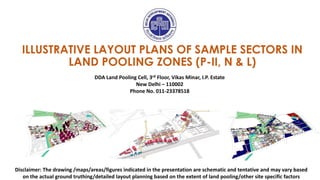
  • 1. ILLUSTRATIVE LAYOUT PLANS OF SAMPLE SECTORS IN LAND POOLING ZONES (P-II, N & L) Disclaimer: The drawing /maps/areas/figures indicated in the presentation are schematic and tentative and may vary based on the actual ground truthing/detailed layout planning based on the extent of land pooling/other site specific factors DDA Land Pooling Cell, 3rd Floor, Vikas Minar, I.P. Estate New Delhi – 110002 Phone No. 011-23378518 M M
  • 3. Sector area (P-II 07- 554/237 Ha) • Presence of a big LDRA and large parcels of forest land. • Bounded by UER II and III on two sides and major ROWs of 80m and 60m respectively on the remaining sides. • Proximity to Zone O and presence of Nalas. Zone – P II L O C A T I O N A N D C O N T E X T I N Z O N E High potential for a sound green-blue infrastructure MUKHMELPUR JINDPUR GADI KHASRO SECTOR 07 SECTOR 07 Disclaimer: The drawing /maps/areas/figures indicated in the presentation are schematic and tentative and may vary based on the actual ground truthing/detailed layout planning based on the extent of land pooling/other site specific factors
  • 4. S E C T O R C O N T E X T SECTOR 7 MOHAMMEDPUR HOLAMBI KALAN ZONE P-II ZONE O ALIPUR SHIV NAGAR ZDP PROPOSED UER- II ZDP PROPOSED UER- III ZONE P-II Sector 07 Total area: 554 Ha Vacant Area: 237 Ha The Sector is bounded by UER II and III to the North and South respectively and major ROWs of 80m and 60m respectively on the west and east. JINDPUR GADI KHASRO MUKHMELPUR Disclaimer: The drawing /maps/areas/figures indicated in the presentation are schematic and tentative and may vary based on the actual ground truthing/detailed layout planning based on the extent of land pooling/other site specific factors
  • 5. BREAK-UP OF 60% LAND 53 % land component for residential (Gross Residential) 125.61 Ha 5% of land component for commercial 11.85 Ha 2% of land component for public-semi public 4.74 Ha DEVELOPABLE LAND (237 Ha) 60% Land Component for Developer Consortium (142.20 Ha) 40% Land Component for City level amenities (94.80 Ha) LEGEND Sector area: 554 Ha Forest Land LDRA Village Abadi Area HT Line Developable Land Area: 237 Ha Existing Nala and Water Bodies Nala Buffer S E C T O R - D E V E L O P A B L E L A N D MUKHMELPUR VILLAGE ABADI AREA ZDP PROPOSED 30M ROW 100M UER II N O T I F I E D L D R A 80M UER III 40% Land would be utilized for provision of roads, greens, City- level PSP, Utilities etc. as per the Notified policy. Disclaimer: The drawing /maps/areas/figures indicated in the presentation are schematic and tentative and may vary based on the actual ground truthing/detailed layout planning based on the extent of land pooling/other site specific factors
  • 6. Strengthening the green-blue network using the sector’s existing green assets like Forest Land and integrating them with MPD Greens Making interlinkages and defining major vehicular networks within the site. Placing district and community facilities closer to major ROWs for better accessibility KEY IDEAS 01 02 03 Understanding the edge conditions to define ‘Character Zones’ of proposed neighbourhoods Proposing a variety of bulit typologies ranging from detached, semi detached housing to walk-up and tower typologies. Three distinct ‘Character Zones’ with Low, Medium and High Densities respectively 04 05 06 Character Zone 02 L O W D E N S I T Y P L O T T E D H O U S I N G Character Zone 03 M E D I U M D E N S I T Y W A L K - U P T Y P O L O G Y S T R U C T U R E D I A G R A M Character Zone 01 H I G H D E N S I T Y T O W E R T Y P O L O G Y PSP EDGE COMMERCIAL EDGE GREEN EDGE LDRA EDGE MAJOR ROW EDGE HIGH-DENSITY VARIABLE FAR RECEIVING ZONE 100M UER II
  • 7. P R O P O S E D S C H E M A T I C L A Y O U T P L A N LEGEND PUBLIC AND SEMI-PUBLIC FACILITES NEIGHBOURHOOD FACILITIES NEIGHBOURHOOD PARKS NEIGHBOURHOOD FACILITIES CONVENIENCE SHOPPING BREAK-UP OF GROSS RESIDENTIAL LAND (125.61Ha) Net Residential (55% of Gross Residential) 69.09 Ha Land for Neighbourhood facilities, green and roads (45% of Gross Residential) 56.52 Ha FAR AND BUILT-UP CALCULATIONS FOR NET RESIDENTIAL DESCRIPTION AREA Net residential area 69.09 Ha Built-up Area (FAR 2) 1381710 Sq.m. Additional EWS Built-up (15% of the net residential built-up area) 207256.50 sqm Total Built-up Area 1588966.50 sqm Assumption Average size of DU – 100sqm Size of EWS – 32 sqm. POPULATION CALCULATIONS DESCRIPTION Estimated Population 91,322 Existing Population +VILLAGE ABADI 16,971 LDRA 12,652 Total Population (including existing) 1,20,946 8 NEIGHBORHOODS (13,000 population / neighborhood) 1 2 1 SOCIO- CULTURAL CENTRE 2 DISTRICT PARK DISTRICT HOSPITAL 4 MULTI-PURPOSE PARK, SPORTS, OTHER COMMUNITY SERVICES 6 COMMUNITY HOSPITAL/ SERVICES 5 COMMUNITY PARK 3 6 5 4 3 5 Disclaimer: The drawing /maps/areas/figures indicated in the presentation are schematic and tentative and may vary based on the actual ground truthing/detailed layout planning based on the extent of land pooling/other factors
  • 8. N E I G H B O U R H O O D S & B L U E G R E E N N E T W O R K FOREST MPD GREENS NAALA SUBWAY CITY PARK CITY PARK COMMUNITY PARK COMMUNITY PARK DISTRICT PARK M U K H M E L A B A D I N O T I F I E D L D R A S S S NEIGHBOURHOOD 01 NEIGHBOURHOOD 02 NEIGHBOURHOOD 04 NEIGHBOURHOOD 06 NEIGHBOURHOOD 07 NEIGHBOURHOOD 08 NEIGHBOURHOOD 05 NEIGHBOURHOOD 03 Disclaimer: The drawing /maps/areas/figures indicated in the presentation are schematic and tentative and may vary based on the actual ground truthing/detailed layout planning based on the extent of land pooling/other site specific factors
  • 9. W A L K A B I L I T Y Making pedestrian and cycling interlinkages between neighbourhoods through community greens, that also integrate with Neighborhood Greens through a continuous 6m pedestrian/ cyclist only network. PEDESTRIAN PATHS AND PLAZAS PEDESTRIAN PATHS THROUGH GREENS SUBWAY NEIGHBOURHOOD 01 NEIGHBOURHOOD 02 NEIGHBOURHOOD 04 NEIGHBOURHOOD 06 NEIGHBOURHOOD 07 NEIGHBOURHOOD 08 NEIGHBOURHOOD 05 NEIGHBOURHOOD 03 M U K H M E L A B A D I N O T I F I E D L D R A S S S Disclaimer: The drawing /maps/areas/figures indicated in the presentation are schematic and tentative and may vary based on the actual ground truthing/detailed layout planning based on the extent of land pooling/other factors
  • 10. D I S T R I B U T I O N O F A M E N I T I E S METRO STATION SUBWAY COMMECIAL DISTRICT PSP (2%) COMMUNITY FACILITIES NEIGHBOURHOOD AMENITIES GOVERNMANT LAND ANCHORS / COMMUNITY NODES M S SUBWAY DISTRICT CENTRE DISTRICT AND COMMUNITY PSP NEIGHBOURHOOD AMENITIES (SCHOOLS) NEIGHBOURHOOD AMENITIES (CONVENIENCE SHOPPING) ANCHORS / COMMUNITY NODES M U K H M E L A B A D I N O T I F I E D L D R A S S S Locating the Neighbourhood facilities within 500m walking distance in all neighbourhoods and providing access to District and Community facilities from major ROWS. Disclaimer: The drawing /maps/areas/figures indicated in the presentation are schematic and tentative and may vary based on the actual ground truthing/detailed layout planning based on the extent of land pooling/other factors
  • 11. V A R I A B L E F A R R E C E I V I N G Z O N E S METRO STATION SUBWAY COMMECIAL DISTRICT PSP (2%) COMMUNITY FACILITIES NEIGHBOURHOOD AMENITIES GOVERNMANT LAND ANCHORS / COMMUNITY NODES M S RECEIVING ZONES (FAR UPTO 4.0) Disclaimer: The drawing /maps/areas/figures indicated in the presentation are schematic and tentative and may vary based on the actual ground truthing/detailed layout planning based on the extent of land pooling/other factors
  • 12. WITH FAR 2 WITH VARIBALE FAR WITH VARIBALE & VERTICAL MIXING V A R I A B L E F A R & V E R T I C A L M I X S C E N A R I O S Disclaimer: The drawing /maps/areas/figures indicated in the presentation are schematic and tentative and may vary based on the actual ground truthing/detailed layout planning based on the extent of land pooling/other factors
  • 13. ZONE N SECTOR 20 Disclaimer: The drawing /maps/areas/figures indicated in the presentation are schematic and tentative and may vary based on the actual ground truthing/detailed layout planning based on the extent of land pooling/other factors
  • 14. Sector area (N-20 380/121 Ha) • Presence of a big laldora and extension and existence of the Bawana industrial area • One side of sector falls on the UER II (100mt) and southern sides on 45mts ROW. • Phase IV of the Delhi Metro proposed to cross through the sector 20 and pass into the Bawana Industrial area. Zone - N L O C A T I O N A N D C O N T E X T I N Z O N E - N High potential for vertical mixing and commercial development BAWANA POOTH KHURD ABADI AREA Disclaimer: The drawing /maps/areas/figures indicated in the presentation are schematic and tentative and may vary based on the actual ground truthing/detailed layout planning based on the extent of land pooling/other factors
  • 15. S E C T O R C O N T E X T BAWANA INDUSTRIAL AREA SECTOR 20 SULTANPUR DABAS POOTH KHURD BARWALA SECTOR 34 SECTOR 29 SECTOR 30 SECTOR 35 PEHLADPUR BANGER JAIN COLONY BAWANA ZONE N ZONE PI ZONE M Disclaimer: The drawing /maps/areas/figures indicated in the presentation are schematic and tentative and may vary based on the actual ground truthing/detailed layout planning based on the extent of land pooling/other factors
  • 16. BAWANA INDUSTRIAL AREA ZONE M ZONE N Sector 20 Total area: 380Ha Vacant Area : 121 Ha PROPOSED 60M ROAD PROPOSED METRO ROUTE PHASE IV PROPOSED METRO STATION The proposed 60m road passes through the Abadi Area and might have to be re-aligned so as not to disturb the existing village abadi ZONE PI L O C A T I O N A N D C O N T E X T I N Z O N E Disclaimer: The drawing /maps/areas/figures indicated in the presentation are schematic and tentative and may vary based on the actual ground truthing/detailed layout planning based on the extent of land pooling/other site specific factors
  • 17. POOTH KHURD VILLAGE ABADI AREA 60 METER PROPOSED ROAD BARWALA PEHLADPUR BANGER BAWANA INDUSTRIAL AREA Reinforcing the natural systems by strengthening the green-blue network within the site. Respecting the existing context and promoting an inclusive development through shared spaces. Utilizing the potential of proposed metro corridor running through the site to zone high density uses and creating walkable neighborhoods. KEY IDEAS 01 02 03 S T R U C T U R E D I A G R A M Lung spaces in the form of parks provided towards the existing settlement as shared resource. Central community spine interlinking different functions and neighborhoods M M Primary circulation corridor Metro influence zones (TDR receiving areas and vertical mixing zones) Disclaimer: The drawing /maps/areas/figures indicated in the presentation are schematic and tentative and may vary based on the actual ground truthing/detailed layout planning based on the extent of land pooling/other factors
  • 18. BREAK-UP OF 60% LAND 53 % land component for residential (Gross Residential) 60.42 Ha 5% of land component for commercial 5.70 Ha 2% of land component for public-semi public 2.28 Ha DEVELOPABLE LAND (114 Ha) 60% Land Component for Developer Consortium (68.4 Ha) 40% Land Component for City level amenities (45.6 Ha) POOTH KHURD VILLAGE ABADI AREA BAWANA INDUSTRIAL AREA 60 METER PROPOSED ROAD S E C T O R - D E V E L O P A B L E L A N D LEGEND Total area: 380Ha Village Abadi Area HT Line and Buffer Developable Land Area: 114 Ha (excld.HT Buffer) Existing Nala and Water Bodies Proposed Metro route (Phase IV) Proposed Metro stations (Phase IV) Disclaimer: The drawing /maps/areas/figures indicated in the presentation are schematic and tentative and may vary based on the actual ground truthing/detailed layout planning based on the extent of land pooling/other site specific factors 40% Land would be utilized for provision of roads, greens, City- level PSP, Utilities etc. as per the Notified policy.
  • 19. HOUSING & NEIGHBORHOOD GREENS P R O P O S E D S C H E M A T I C L A Y O U T P L A N Legend- METRO ROUTE (PHASE IV) METRO STATIONS (PHASE IV) DISTRICT PSPs (40%) DISTRICT PSP (2%) COMMUNITY FACILITIES NEIGHBOURHOOD AMENITIES SCHOOLS PARKS & OPEN SPACES COMMERCIAL RESIDENTIAL GOVERNMENT LAND 4 NEIGHBORHOODS (11,000 population / neighborhood) BREAK-UP OF GROSS RESIDENTIAL LAND (60.42 Ha) Net Residential (55% of Gross Residential) 33.23 Ha Land for facilities, green and roads (45% of Gross Residential) 27.18 Ha FAR AND BUILT-UP CALCULATIONS FOR NET RESIDENTIAL DESCRIPTION AREA Net residential 33.23 Ha Built-up Area (FAR 2) 6,64,620 sqm Additional EWS Built-up (15% of the net residential built-up area) 99,693 sqm Total Built-up Area 7,64,313 sqm POPULATION CALCULATIONS DESCRIPTION Total Number of Households 9,761 Estimated Population (Developable land) 43,927 D D D D D NF (S) NF (S) NF (S) NF (S) NF NF NF NF NF NF C C C C C C C C D D C NF NF (S) Disclaimer: The drawing /maps/areas/figures indicated in the presentation are schematic and tentative and may vary based on the actual ground truthing/detailed layout planning based on the extent of land pooling/other site specific factors
  • 20. N E I G H B O U R H O O D S & W A L K A B I L I T Y Creating a walkable network through housing & neighborhood parks, community greens, pedestrian streets, subways etc. S S S M M NEIGHBOURHOOD 01 NEIGHBOURHOOD 02 NEIGHBOURHOOD 03 NEIGHBOURHOOD 04 GOVERNMANT LAND PATHWAYS PEDESTRIAN STREETS Disclaimer: The drawing /maps/areas/figures indicated in the presentation are schematic and tentative and may vary based on the actual ground truthing/detailed layout planning based on the extent of land pooling/other site specific factors
  • 21. D I S T R I B U T I O N O F A M E N I T I E S Creating a central community spine for cultural exchange supported by a network of public open spaces, pedestrian streets and amenities that create cross-links between neighborhoods and brings people from all walks of life together into one space. M M S S S METRO STATION SUBWAY COMMECIAL DISTRICT PSP (2%) COMMUNITY FACILITIES NEIGHBOURHOOD AMENITIES GOVERNMANT LAND ANCHORS / COMMUNITY NODES M S Reinforcing the existing drainage network running within the site and integrating it with the site-wide park system. Disclaimer: The drawing /maps/areas/figures indicated in the presentation are schematic and tentative and may vary based on the actual ground truthing/detailed layout planning based on the extent of land pooling/other site specific factors
  • 22. V A R I B A L E F A R R E C E V I N G Z O N E & V E R T I C A L M I X I N G Z O N E S Connecting People to Public Transit : Concentrating density in the form of Variable FAR receiving Zones, affordable housing, retail and business anchors within a 5-minute walking radius from metro stations, we can reduce the dependency on private vehicles within the township. M M VERTICAL MIXING (plot size >5000sqm & FAR 3.0) VARIBALE FAR RECEIVING ZONES (FAR 4.0) GOVERNMANT LAND Disclaimer: The drawing /maps/areas/figures indicated in the presentation are schematic and tentative and may vary based on the actual ground truthing/detailed layout planning based on the extent of land pooling/other site specific factors
  • 23. ZONE L SECTOR 03 Disclaimer: The drawing /maps/areas/figures indicated in the presentation are schematic and tentative and may vary based on the actual ground truthing/detailed layout planning based on the extent of land pooling/other site specific factors
  • 24. L O C A T I O N A N D C O N T E X T I N Z O N E L TIKRIKALAN NEELWAL JAFARPUR HIRANKUDNA Sector with high Potential for variable FAR receiving and Transit Oriented Development (TOD) Sector area (L-3-302/210 Ha) • Strategically located- UER I (80 mt) on the one side and 45 mt ROW on other 2 sides. • Falls on the major Existing road. • Less built area with a Lal dora (Neelwal). • Existing development in the adjacent sectors supports the potential for commercial development. Disclaimer: The drawing /maps/areas/figures indicated in the presentation are schematic and tentative and may vary based on the actual ground truthing/detailed layout planning based on the extent of land pooling/other site specific factors
  • 25. S E C T O R C O N T E X T ZONE L Bakkarwala Existing ESS पीवीसी मार्क े ट Existing Industrial Refinery Refinery M M M ZONE K-I Sector 03 Total area: 302Ha Vacant Area: 210 Ha SECTOR BOUNDARY EXISTING ROAD NH10 SAWDA GHERA ROAD METRO STATION M LAL DORA’S EXISTING ESS PVC MARKET PROPOSED ROAD NETWORK UER I (80 MT ROW) 45 MT ROW 30 MT ROW टटर्करी र्कलाां नीलवाल जाफर पुर टिरन र्क ु दना Disclaimer: The drawing /maps/areas/figures indicated in the presentation are schematic and tentative and may vary based on the actual ground truthing/detailed layout planning based on the extent of land pooling/other site specific factors
  • 26. ZONE K- I ZONE L S I T E O P P O R T U N I T I E S ZONE N ZONE K-I KEY OPPORTUNITIES IDEAS 01 Utilization the potential of Two UER on both side, through the active edges and high density (variable FAR receiving zone)and promoting accessed walkable green Strengthening natural systems by creating green-blue network within the site. 02 03 Accessing opportunity for shared commercial development along the UER I. 04 Connectivity created opportunity for placing city level pubic services CITY LEVEL -PSP DISTRICT CENTRE Disclaimer: The drawing /maps/areas/figures indicated in the presentation are schematic and tentative and may vary based on the actual ground truthing/detailed layout planning based on the extent of land pooling/other site specific factors
  • 27. 40% Land Component for City level amenities (84 Ha) S E C T O R - D E V E L O P A B L E L A N D 60% Land Component for Developer Consortium (126 Ha) BREAK-UP OF 60% LAND 53 % residential (Gross Residential) 111.3 Ha 5% for commercial 10.5 Ha 2% for public-semi public 4.2 Ha DEVELOPABLE LAND (210 Ha) LEGEND Total area: 380Ha Village Abadi Area Developable Land Area: 210 Ha Existing Nala and Water Bodies Proposed UER I (80mt Row) Neelwal Hiran Kudna 45mt ROW 40% Land would be utilized for provision of roads, greens, City-level PSP, Utilities etc. as per the Notified policy. Disclaimer: The drawing /maps/areas/figures indicated in the presentation are schematic and tentative and may vary based on the actual ground truthing/detailed layout planning based on the extent of land pooling/other site specific factors
  • 28. Reinforcing the natural systems by strengthening the green-blue network within the site. Respecting the existing context and promoting an inclusive development through shared spaces. Demonstrating a poly- centric development model. Creating walkable & safe neighborhoods. KEY IDEAS 01 02 03 S T R U C T U R E D I A G R A M NEELWAL HIRAN KUDNA GREEN NODE COMMERCIAL NODE INSTITUTIONAL NODE CENTRAL ANCHOR (Community facilities & Iconic towers) High-rise residential towers High-rise residential towers Mid-rise residential towers Mid-rise residential towers Low-rise plotted Bungalows 45M Road 04 Disclaimer: The drawing /maps/areas/figures indicated in the presentation are schematic and tentative and may vary based on the actual ground truthing/detailed layout planning based on the extent of land pooling/other site specific factors
  • 29. ZONAL- Medical college 1 2 3 4 5 6 7 DISTRICT Centre- CBD DISTRICT Bus Depot, & Terminal ZONAL-Religious & Burial COMMUNITY SERVICES DISTRICT - PARK DISTRICT- Hospital services P R O P O S E D S C H E M A T I C L A Y O U T P L A N LAND-USE PLAN BREAK-UP OF GROSS RESIDENTIAL LAND (111.3 Ha) Net Residential (53% of 55% Gross Residential) 61.22 Ha Land for PSP facilities, green and roads (45% of Gross Residential) 50.08 Ha FAR AND BUILT-UP CALCULATIONS FOR NET RESIDENTIAL DESCRIPTION AREA (HA) Net residential 61.22 Ha Built-up Area (FAR 2) 12,24,300 sq mt Additional EWS Built-up (15% of the net residential built-up area) 183645 sq mt Total Built-up Area 14,07,945 sq mt 18mt ROW 24mt ROW 24mt ROW 18mt ROW 12mt ROW 12mt ROW 12mt ROW 18mt ROW 12mt ROW PSPs COMMERCIAL -DISTRICT CENTRE RESIDENTAIL GOVERNMENT GREEN PSP RECERATIONAL (CP, DP) EXISTING ABADIES 1 4 6 2 3 6 6 7 5 16 HOUSING UNITS 08 NEIGHBORHOODS POPULATION CALCULATIONS DESCRIPTION Estimated Population 80,919 Existing Population +VILLAGE ABADI 6,191 Total Population (including existing) 87,109 Disclaimer: The drawing /maps/areas/figures indicated in the presentation are schematic and tentative and may vary based on the actual ground truthing/detailed layout planning based on the extent of land pooling/other site specific factors
  • 30. N E I G H B O U R H O O D S NEIGHBOURHOOD 04 NEIGHBOURHOOD 05 NEIGHBOURHOOD 06 NEIGHBOURHOOD 07 NEIGHBOURHOOD 08 NEIGHBOURHOOD 03 NEIGHBOURHOOD 02 NEIGHBOURHOOD 01 Disclaimer: The drawing /maps/areas/figures indicated in the presentation are schematic and tentative and may vary based on the actual ground truthing/detailed layout planning based on the extent of land pooling/other site specific factors
  • 31. W A L K A B L E S T R E E T S & B L U E G R E E N N E T W O R K Reinforcing the existing drainage network running within the site and integrating it with the site-wide park system. O O W A L K A B L E S T R E E T S Disclaimer: The drawing /maps/areas/figures indicated in the presentation are schematic and tentative and may vary based on the actual ground truthing/detailed layout planning based on the extent of land pooling/other site specific factors
  • 32. NEIGHBOURHOOD 04 NEIGHBOURHOOD 05 NEIGHBOURHOOD 06 NEIGHBOURHOOD 07 NEIGHBOURHOOD 08 NEIGHBOURHOOD 03 NEIGHBOURHOOD 02 NEIGHBOURHOOD 01 D I S T R I B U T I O N O F A M E N I T I E S COMMERCIAL INSTITUTIONAL / PSPS CITY LEVEL PSPS Creating a central community spine (along 30M wide central ring road) for cultural exchange supported by a network of public open spaces, pedestrian streets and amenities that create cross-links among eight neighborhoods. Disclaimer: The drawing /maps/areas/figures indicated in the presentation are schematic and tentative and may vary based on the actual ground truthing/detailed layout planning based on the extent of land pooling/other site specific factors
  • 33. C H A R A C T E R Z O N E S Eight neighborhoods mostly comprises of three distinct character zones – vertical mixing zones, standard group housing plots and plotted bungalow zones. Vertical mixing zones have been placed along the central ring road and zonal roads. VERTICAL MIXING ZONE 1 (plot size >5000sqm & FAR 3.0) VERTICAL MIXING ZONE 2 (plot size >5000sqm & FAR 4.0) STANDARD GROUP HOUSING PLOTS (plot size >5000sqm & FAR 2.0) PLOTTED BUNGALOW AREA (plot size <2000sqm) Disclaimer: The drawing /maps/areas/figures indicated in the presentation are schematic and tentative and may vary based on the actual ground truthing/detailed layout planning based on the extent of land pooling/other site specific factors
  • 34. D I S C L A I M E R The amenities, specifications, facilities, surrounding infrastructure, stock images and features shown and/or mentioned and the image renders used herein are purely indicative and for awareness. These may differ from the actuals. All figures and photographs in this document are for representation only. The information in presentation/ brochure/ booklet/ prospectus /advertisement is based on Land Pooling Policy/ Regulations notified by Central Government/DDA, however, incase of any conflict/ discrepancy the notified Land Policy, S.O. 5220(E) dated 11 October, 2018 would prevail. In no event will Delhi Development Authority (for the sake of brevity referred to as "DDA" or its employees/representatives be liable for any loss or damages arising from the use of or reliance on information provided in this document. The use of any information or material in this document is entirely at the viewer (land owner/ applicant/ developer/ investor etc.) own risk. DDA reserves the right to change, alter, add or delete any of the specifications mentioned herein without prior permission or notice subject however to the applicable laws. The graphics used in this presentation/ booklet are only for non-profit educational purpose and may not be covered/ may be exempted for any copyright infringement.