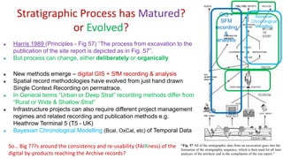
Download to read offline
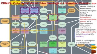
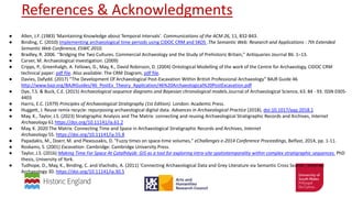
![CIDOC CRM - CRMarchaeo
“Archaeological Excavation Process” extension – followed on from CRM-EH
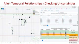
Fig. 4: Section drawing with A3 Stratigraphic Interfaces in square brackets [ ], A2 Stratigraphic Volume
Unit in round brackets (), the surfaces S1 and S2 created through A1 Excavation Process Units using
different methodologies and an A7 Embedding of a coin.
A1 Excavation Process Unit
A1 Excavation Process Unit
A3 Stratigraphic Interface
A2 Stratigraphic Volume Unit
A7 Embedding
AP4 produced surface S1
with stratigraphic method
AP4 produced surface S2
with spit excavation method
CRMarchaeo v 1.4.8 (Feb 2019)
Image
Copyright
Lucasfilm](https://image.slidesharecdn.com/keithmays12caa2023amsterdam-230427130644-c58dd644/85/Keith_May_S12_CAA2023_Amsterdam-pptx-5-320.jpg)
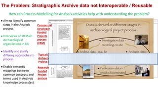
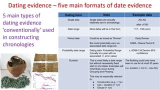

The document outlines conventions for archaeological stratigraphic and chronological data, emphasizing the need for consistent standards in digital records. It discusses methodologies, challenges, and the evolution of archaeological stratigraphy while considering various factors influencing data outputs. The aim is to improve data interoperability and reuse in archaeological practices and research.


![[DSC Europe 25] Slobodan Dolinic - Smart and Intelligent Green Region.pptx](https://cdn.slidesharecdn.com/ss_thumbnails/0bribinjsp6ghwtvsvor-2-sigre-slobodan-dolinic-260115093812-c9c10e90-thumbnail.jpg?width=640&height=640&fit=bounds)

![[DSC Europe 25] Elena Menshikova - AI-Powered Operational Excellence: Revolut...](https://cdn.slidesharecdn.com/ss_thumbnails/es6nholbqy3zaao2c2yd-2-elena-menshikova-data-ai-in-decision-making-260115093812-4fba8b38-thumbnail.jpg?width=640&height=640&fit=bounds)

![[DSC Europe 25] Andrzej Kowalczyk - AI - how to start small and grow in the f...](https://cdn.slidesharecdn.com/ss_thumbnails/oy1zmo94qv6vpcqjvno2-andrzej-kowalczyk-ai-how-to-start-small-and-grow-in-the-future-1-260119121559-cf093b23-thumbnail.jpg?width=640&height=640&fit=bounds)


