Download as PDF, PPTX


![29
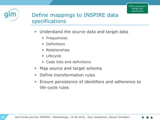
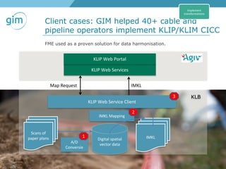
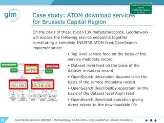
The INSPIRE data specifications are
expressed as a UML data model
GeoTrends seminar INSPIRE - Methodology, 15-06-2016, Stijn Goedertier, Steven Smolders
Define mappings to
INSPIRE data
specifications
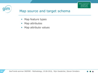
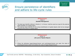
class AdministrativeUnit
«featureType»
AdministrativeUnit
+ country: CountryCode
+ geometry: GM_MultiSurface
+ inspireId: Identifier
+ name: GeographicalName [1..*]
+ nationalCode: CharacterString
+ nationalLevel: AdministrativeHierarchyLevel
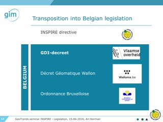
«voidable, lifeCycleInfo»
+ beginLifespanVersion: DateTime
+ endLifespanVersion: DateTime [0..1]
«voidable»
+ nationalLevelName: LocalisedCharacterString [1..*]
+ residenceOfAuthority: ResidenceOfAuthority [1..*]
constraints
{CondominiumsAtCountryLevel}
{AdmininstrativeUnitHighestLevel}
{AdministrativeUnitLowestLevel}
«codeList»
AdministrativeHierarchyLevel
+ 1stOrder
+ 2ndOrder
+ 3rdOrder
+ 4thOrder
+ 5thOrder
+ 6thOrder
«dataType»
Geographical Names::GeographicalName
+ spelling: SpellingOfName [1..*]
«voidable»
+ grammaticalGender: GrammaticalGenderValue [0..1]
+ grammaticalNumber: GrammaticalNumberValue [0..1]
+ language: CharacterString
+ nameStatus: NameStatusValue
+ nativeness: NativenessValue
+ pronunciation: PronunciationOfName
+ sourceOfName: CharacterString
«dataType»
ResidenceOfAuthority
+ name: GeographicalName
«voidable»
+ geometry: GM_Point
+lowerLevelUnit
«voidable» 0..*
+upperLevelUnit
«voidable» 0..1
+/administeredBy
«voidable» 0..*
+coAdminister
«voidable» 0..*
http://inspire.ec.europa.eu/data-model/approved/r4618-ir/html](https://image.slidesharecdn.com/2016-06-15-gim-geotrends-inspire-data-harmonisation-methodology-tools-160615141547/85/INSPIRE-Data-harmonisation-methodology-and-tools-29-320.jpg)
![38
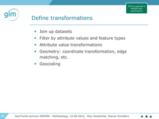
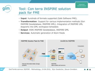
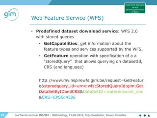
Ensure persistence of identifiers
and adhere to life-cycle rules
GeoTrends seminar INSPIRE - Methodology, 15-06-2016, Stijn Goedertier, Steven Smolders
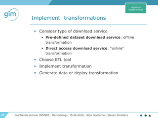
▶ INSPIRE Identifier (inspireID): exactly 1
▶ localId: external identifier
▶ namespace: unique ID of data
source
▶ versionID: id of version (2007-02-
12T12:12:12+05:30)
▶ Thematic identifier: 0, 1 or more used for data
linking
▶ Which namespace to use?
▶ Namespace register?
▶ GCM Annex H on HTTP URIs
class Base Types
«dataType»
Identifier
+ localId: CharacterString
+ namespace: CharacterString
«lifeCycleInfo, voidable»
+ versionId: CharacterString [0..1]
class Base Types
«dataType»
Base Types 2::ThematicIdentifier
+ identifier: CharacterString
+ identifierScheme: CharacterString
Define mappings to
INSPIRE data
specifications](https://image.slidesharecdn.com/2016-06-15-gim-geotrends-inspire-data-harmonisation-methodology-tools-160615141547/85/INSPIRE-Data-harmonisation-methodology-and-tools-38-320.jpg)
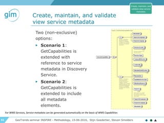
![39
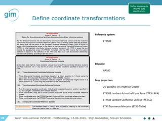
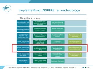
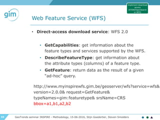
Ensure persistence of identifiers
and adhere to life-cycle rules
GeoTrends seminar INSPIRE - Methodology, 15-06-2016, Stijn Goedertier, Steven Smolders
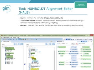
Life-cycle: From start to end of spatial object
▶ Version-cycle: Part of spatial object’s life-cycle
Validity: real-world phenomenon.
Example:
▶ t1 = building is built
▶ t3 = building is demolished
▶ t2 = building function changed (office -> residential)
class Base Types
«featureType»
CadastralParcels::CadastralParcel
+ geometry: GM_Object
+ inspireId: Identifier
+ label: CharacterString
+ nationalCadastralReference: CharacterString
«voidable»
+ areaValue: Area [0..1]
+ referencePoint: GM_Point [0..1]
+ validFrom: DateTime [0..1]
+ validTo: DateTime [0..1]
«lifeCycleInfo, voidable»
+ beginLifespanVersion: DateTime
+ endLifespanVersion: DateTime [0..1]
A
Define mappings to
INSPIRE data
specifications](https://image.slidesharecdn.com/2016-06-15-gim-geotrends-inspire-data-harmonisation-methodology-tools-160615141547/85/INSPIRE-Data-harmonisation-methodology-and-tools-39-320.jpg)


The document outlines the agenda and key topics discussed during the Geotrends Seminar on Inspire Data Harmonisation, held on June 15, 2016, including the legal obligations and methodologies for ensuring interoperability of spatial datasets and services. It highlights the Inspire directive's objective to enhance public access to environmental spatial data across Europe, as well as technical methodologies for implementing the directive. Additionally, the document features case studies and practical demonstrations related to data harmonisation and interoperability best practices.