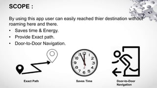
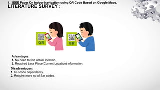
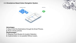
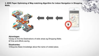
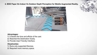
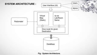
By using pedometer(Step counts) i am trying to navigate the user in virtual map with Navigation.
It is basically useful in wide areas, eg : Hospitals,Organisations ,Museums and Institutions.
1 Camera-A webcam captures and recognizes an object in view and tracks the user’s hand gestures using computer-vision based techniques.It sends the data to the smart phone. The camera, in a sense, acts as a digital eye, seeing
what the user sees. It also tracks the movements of the thumbs and index fingers of both of the user's hands. The camera recognizes objects around you instantly, with the micro-projector overlaying the information on any surface, including the object itself or your hand.
2 Projector- a projector opens up interaction and sharing. The project itself contains a battery inside,with 3 hours of battery life. The projector projects visual information enabling surfaces, walls and physical objects around us to be used as interfaces. We want this thing to merge with the
physical world in a real physical sense. You are touching that object and projecting info onto that object. The information will look like it is part of the object. A tiny LED projector
displays data sent from the smart phone on any surface in view–object, wall, or person.
3 Mirror-The usage of the mirror is significant as the projector dangles pointing downwards from
the neck.
4 Mobile Component-The mobile devices like Smartphone in our pockets transmit and receive voice and data anywhere and to anyone via the mobile internet. An accompanying Smartphone runs the Sixth-sense software, and handles the connection to the internet. A Web-enabled smart phone
in the user’s pocket processes the video data. Other software searches the Web and interprets the hand gestures.
5 Color Markers-It is at the tip of the user’s fingers. Marking the user’s fingers with red, yellow, green, and blue tape helps the webcam recognize gestures. The movements and arrangements of these makers are interpreted into gestures that act as interaction instructions for the projected
application interfaces.
Working-The hardware that makes Sixth Sense work is a pendant like mobile wearable interface It has a camera, a mirror and a projector and is connected wireless to a Bluetooth or 3G or wifi smart phone that can slip comfortably into one’s pocket The camera recognizes individuals, images, pictures, gestures one makes with their hands Information is sent to the Smartphone for processing The downward-facing projector projects the output image on to the mirror.Mirror reflects image on to the desired surface Thus, digital information is freed from its confines and placed in the physical world.
Nextome - Indoor Navigation System | MIP Politecnico di MilanoDomenico Colucci
Nextome is an indoor positioning and navigation system based on an infrastructure of devices compatible with Apple iBeacon standard and smartphones, either iOS or Android, provided with Bluetooth 4.0LE technology.
Domenico Colucci co-founder of Nextome, introduced for the course "App Academy - Samsung", the innovative and patented technology for indoor navigation.
The following photos were entirely taken and processed by me with an iPhone. See more: http://paulgordonbrown.com/category/iphoneography/
iPhoneography is the art of creating photos with an Apple iPhone. This is a style of mobile photography that differs from all other forms of digital photography in that images are both shot and processed on the iOS device.
Location-aware and mapping applications have gone from a desirable feature to an essential
part of any smart phone. Whether a user is checking into a social network, looking for a
pharmacy in the middle of the night, or located in somewhere and needs help, the key is always
the same: location.
In this project, an Android mapping application is developed. The application is able to display
the map of the whole world while online or, display a pre-downloaded map while offline, track
the user’s location, display a compass to determine north, send the user’s location to others in
case of emergency using SMS, receive and interpret received location from the message, display
it on the map, and notify the user by the reception of the location.
The application was developed using agile methodology. It, met its objectives and successfully
passed 91% of the final system test, recording that some limitations were discovered, the
application needs further testing and can be implemented for particular company or university
using their own maps or editing the maps in OSM (open street maps).
In this project, we describe a unique architecture for indoor navigation that integrates behavior recognition, multisensory indoor localization, and path-planning in order to pro-actively provide directions without direct input from users. To our knowledge, this is the first architecture that attempts to integrate the core navigation components of path planning and localization with intent prediction towards a more refined navigation solution. The system comprises of three core components: augmented reality, map representation and route planning, and plan recognition.
To achieve effective localization, we provide pre-built maps using QR code scanning distributed at various places of the indoor location. We are using Augmented Reality to make an intuitive and user friendly interface which uses QR codes for identification of various maps that are pre uploaded in the QR codes for the ease of users.
CommutEaze is a mobile application that intends to make people’s experience of
commuting in buses easier and richer.
Everyday, thousands of people use public bus transport systems in the towns and cities
of India. And everyday, the commute gets a little more tiresome, the buses a little more
crowded and a sense of general well being in the commuters, a little more faded.
We board buses not knowing if we would get a place to sit at any point on the long journey
home, or to work, or on our way to see our loved ones.
CommutEaze aims to help the everyday commuters who battle all odds in order to
transverse distances, great or small, to their destinations.This app will provide commuters
and transport providers with details of bus vacancies and track their positions en route in
real time.
Utilising the Virtual World for Urban Planning and DevelopmentDavid Jonas
Paper presented to FIG2014 in Kuala Lumpur.
The objective of this paper is to describe how virtual urban citymodels are assisting those in the planning process to better understand the development and then communicate outcomes to the various stakeholders. This paper will discuss the process from user needs assessment, data acquisition, visualisation, proposal dissemination and stakeholder input. The pros and cons of the various options at each of these steps will be presented.
Autonomous Campus Tour Guide Robot by using Ultrasonic Range Sensors and QR c...ShwetonKedia
This undertaking depends on QR (Quick Response) codes to give area references to portable robots. The versatile robot is outfitted with a Smartphone that is modified to identify and peruse data on QR codes that are deliberately put in the working condition of the robot. The portable robot can play out the self-governing keep running all through the guide course by utilizing ongoing QR code acknowledgment. The lab data on QR code is played to the guests utilizing Text-to-Speech gave through Android gadget. Ultrasonic range sensors which can distinguish articles and measure separations with high precision are utilized to actualize the divider following and obstruction evasion practices. The gathered sonar data by ultrasonic range sensors is processed by a microcontroller that self-sufficiently controls the tour guide robot. A calculation dependent on the Proportional-integral-derivative (PID) control is applied to the tour guide robot to perform increasingly precise robot movement control. A Bluetooth innovation is utilized to send flag to the Arduino from the Smartphone to operate the tour guide robot remotely.
Laboratory Access Implementing QR Code Authentication Using OTPIJCI JOURNAL
Laboratories in colleges are used to give lectures to students, but what about after working hours? Students can get many benefits from these labs after working hours. For example, students can study and do their homework after working hours. In this project, we have proposed a new technique to control the access of these laboratories. Our idea is to use an encrypted QR code with an TOTP authentication that will be connected to LAN network to guarantee that each student enter can only use a single PC. Each student will have his own encrypted QR code that differs from other students. The TOTP code will be sent to student’s university email. The encryption method used encrypted method used AES encryption to encrypt the data inside the QR code to guarantee the confidentiality, integrity, non-repudiation, and authenticity of the date.
Sachpazis:Terzaghi Bearing Capacity Estimation in simple terms with Calculati...Dr.Costas Sachpazis
Terzaghi's soil bearing capacity theory, developed by Karl Terzaghi, is a fundamental principle in geotechnical engineering used to determine the bearing capacity of shallow foundations. This theory provides a method to calculate the ultimate bearing capacity of soil, which is the maximum load per unit area that the soil can support without undergoing shear failure. The Calculation HTML Code included.
Cosmetic shop management system project report.pdfKamal Acharya
Buying new cosmetic products is difficult. It can even be scary for those who have sensitive skin and are prone to skin trouble. The information needed to alleviate this problem is on the back of each product, but it's thought to interpret those ingredient lists unless you have a background in chemistry.
Instead of buying and hoping for the best, we can use data science to help us predict which products may be good fits for us. It includes various function programs to do the above mentioned tasks.
Data file handling has been effectively used in the program.
The automated cosmetic shop management system should deal with the automation of general workflow and administration process of the shop. The main processes of the system focus on customer's request where the system is able to search the most appropriate products and deliver it to the customers. It should help the employees to quickly identify the list of cosmetic product that have reached the minimum quantity and also keep a track of expired date for each cosmetic product. It should help the employees to find the rack number in which the product is placed.It is also Faster and more efficient way.
Immunizing Image Classifiers Against Localized Adversary Attacksgerogepatton
This paper addresses the vulnerability of deep learning models, particularly convolutional neural networks
(CNN)s, to adversarial attacks and presents a proactive training technique designed to counter them. We
introduce a novel volumization algorithm, which transforms 2D images into 3D volumetric representations.
When combined with 3D convolution and deep curriculum learning optimization (CLO), itsignificantly improves
the immunity of models against localized universal attacks by up to 40%. We evaluate our proposed approach
using contemporary CNN architectures and the modified Canadian Institute for Advanced Research (CIFAR-10
and CIFAR-100) and ImageNet Large Scale Visual Recognition Challenge (ILSVRC12) datasets, showcasing
accuracy improvements over previous techniques. The results indicate that the combination of the volumetric
input and curriculum learning holds significant promise for mitigating adversarial attacks without necessitating
adversary training.
Industrial Training at Shahjalal Fertilizer Company Limited (SFCL)MdTanvirMahtab2
This presentation is about the working procedure of Shahjalal Fertilizer Company Limited (SFCL). A Govt. owned Company of Bangladesh Chemical Industries Corporation under Ministry of Industries.
CFD Simulation of By-pass Flow in a HRSG module by R&R Consult.pptxR&R Consult
CFD analysis is incredibly effective at solving mysteries and improving the performance of complex systems!
Here's a great example: At a large natural gas-fired power plant, where they use waste heat to generate steam and energy, they were puzzled that their boiler wasn't producing as much steam as expected.
R&R and Tetra Engineering Group Inc. were asked to solve the issue with reduced steam production.
An inspection had shown that a significant amount of hot flue gas was bypassing the boiler tubes, where the heat was supposed to be transferred.
R&R Consult conducted a CFD analysis, which revealed that 6.3% of the flue gas was bypassing the boiler tubes without transferring heat. The analysis also showed that the flue gas was instead being directed along the sides of the boiler and between the modules that were supposed to capture the heat. This was the cause of the reduced performance.
Based on our results, Tetra Engineering installed covering plates to reduce the bypass flow. This improved the boiler's performance and increased electricity production.
It is always satisfying when we can help solve complex challenges like this. Do your systems also need a check-up or optimization? Give us a call!
Work done in cooperation with James Malloy and David Moelling from Tetra Engineering.
More examples of our work https://www.r-r-consult.dk/en/cases-en/
Welcome to WIPAC Monthly the magazine brought to you by the LinkedIn Group Water Industry Process Automation & Control.
In this month's edition, along with this month's industry news to celebrate the 13 years since the group was created we have articles including
A case study of the used of Advanced Process Control at the Wastewater Treatment works at Lleida in Spain
A look back on an article on smart wastewater networks in order to see how the industry has measured up in the interim around the adoption of Digital Transformation in the Water Industry.
2. INTRODUCTION :
Indoor navigation deals with navigation within buildings.
By using different technologies we can navigate the inside
area of the buildings/campus is called Indoor Navigation.
4. PROBLEM STATEMENT :
Destination where he want's to go to overcome this problem we are
trying to build a new concept called Indoor Navigation using
Pedometer.
With the help of Pedometer(Steps counts) in virtual map user can
easily reached thier destination without roaming here and there.
5. SCOPE :
By using this app user can easily reached thier destination without
roaming here and there.
• Saves time & Energy.
• Provide Exact path.
• Door-to-Door Navigation.
Exact Path Saves Time Door-to-Door
Navigation
6. LITERATURE SURVEY :
1. IEEE Paper On Indoor Navigation using QR Code Based on Google Maps.
Advantages:
1. No need to find actual location.
2. Required Less Place(Current Location) information.
Disadvantages:
1. QR code dependency.
2. Require more no of Bar codes.
7. 2. A Smartphone Based Indoor Navigation System.
Advantages:
1. Easy to find the Destinations through the Smart Phones.
2. Runs in Every phones.
Disadvantages :
1. Requires more Routers for location Detection.
2. Implementation is not possible Without routers.
8. 3. IEEE Paper Optimizing of Map matching Algorithm for indoor Navigation in Shopping
Malls.
Advantages:
1.Easy to find the Destinations of wide areas eg.Shopping Malls.
2.Time and efforts saving.
Disadvantes:
1.Requires Basic knowledge about the name of visited place.
9. 4. IEEE Paper On Indoor Vs Outdoor Depth Perception for Mobile Augmented Reality.
Advantages:
1. It Saves the time and efforts of the user.
2. Reached the Destination Easily.
3. Provide User Friendly Interface.
Disadvantes:
1. Runs only supported Devices.
2. Required more memory space.
10. SYSTEM ARCHITECTURE : User Interface (UI)
Virtual
Map
(Static)
i/p as
Lab/Room
Name
Pedometer
DataBase
Give route for given
Destination
Users
Admin
Fig : System Architecture.
11. FUTURE SCOPE :
In future Users can use this app in Private as well as Public Sectors /
Organisation because these are the most visiting and wide areas where the
peoples are wasting their time for finding the things which will not known by the
visitors.
Visiting Areas such as ,
• Hospitals.
• Organisations.
• Museums.
• Institutions/Colleges.
• etc..