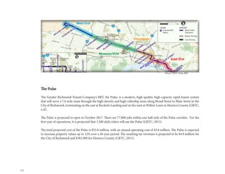
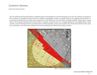
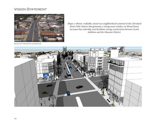
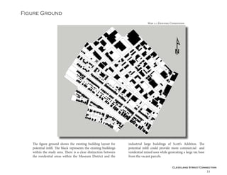
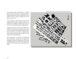
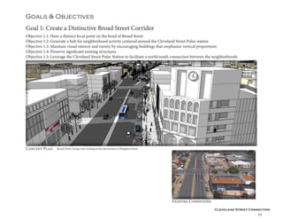
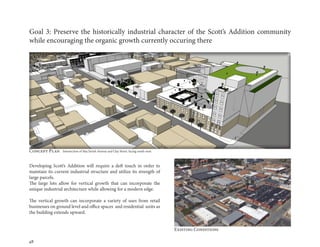
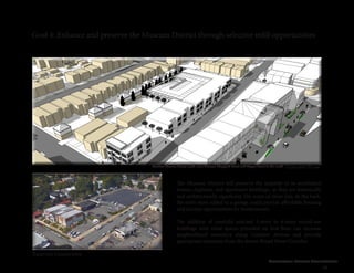
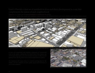
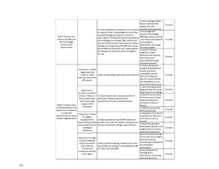
Cleveland Street Connection
1
Virginia Commonwealth University
Dept. Of Urban and Regional Planning
May 2016
Cleveland Street Connection:
A Transit Oriented Development Plan
2
Cleveland Street Connection
3
Acknowledgements
This plan would not be possible without the help and guidance from Mark A. Olinger,
Kathleen Onufer, Daniel Thompson, Will Palmquist, Jesse Revilla, and Josh Son from
the City of Richmond; Will Sanford and Josh Mallow from the Richmond Regional
Planning District Commission; and from Zoe Anne Green from the Museum District
Association.
We would also like to thank the City of Richmond’s Department of Public Works for the
use of their conference room.
The Studio I Team -
	 Instructor: 	James C. Smither, ASLA
	 Students: 	 Aidan Quirke, Crystal Castleberry
			 Elizabeth Greenfield, Haley Angel,
			 Joseph Costello, Jonah Lampkin
			 Lauren Cross, Lois Milone
			 Michal Voscek, Michaela Martin
			 Mina Monavarian, and Tyler Walter
4
Cleveland Street Connection
5
Executive Summary
ThisdocumentwasproducedfortheCityofRichmondasaTransit-
Oriented Development Plan focused on the proposed Cleveland
Street Pulse Station. It also fulfills the Studio I requirement in
the Masters of Urban and Regional Planning Program at Virginia
Commonwealth University.
The City of Richmond requested a plan that will inform the
creatation of a vibrant walkable community within a quarter-
mile of the Cleveland Street Pulse Station. The plan will focus
on creating a cohesive, yet unique, station design that will draw
together two neighborhoods: the Museum District and Scotts
Addition, with Broad Street acting as the binding element.
The Cleveland Street Connection will provide a vision for future
development and infill in the area. The goals of the plan are
to develop a walkable environment, create a distinctive Broad
Street corridor, and provide a clear set of standards to drive and
direct development in a way the complements the nature of the
surrounding neighborhoods. Additionally, the plan seeks to
preserve the historically industrial character of the Scott’s
Addition community while encouraging the organic growth
currently occurring there, as well as enhance and preserve the
Museum District through selective infill opportunities.
The existing conditions for land use examined 660 parcels located
within a quarter-mile radius of the proposed Cleveland Street
Station. The analysis found that the high number of special
use permits in the Scott’s Addition neighborhood converting
industrial spaces into residential illustrated the current trend in
the study area for a mix of uses among commercial, industrial
and residential. In addition, the market analysis revealed a need
for more affordable housing options within the study area, as
housing and rental prices are out of reach for the median incomes
for many the of individuals living in within the area. Over the
last several years, wages have remained stagnant, while housing
costs have continued to increase.
Intersection of Broad Street and Boulevard
6
Analysis of the current zoning found that the present zoning
structure identified several challenges that may restrict development.
The area’s commercial zoning districts are open ended, allowing
the development of multiple commercial uses that are unrelated
and unconnected. The zoning ordinance enumerates multiple uses
permitted by right that range in scale and are distinct from each
other. Furthermore, the current arrangement of commercial uses
and structures in the area are incompatible to each other and lack
organization in scale and design leaving the area with little visual
engagement to generate activities for potential BRT riders of the
Cleveland Street Pulse Station.
We collected and analyzed a variety of demographic data, including
the income, race, ethnicity, and age of residents in the area. While
the study area had a higher median income and less residents in
poverty than the City of Richmond as a whole, the dramatic spatial
distribution highlighted the north/south divide on Broad Street. Race
and ethnicity’s spatial distribution was similar to median income as
it also emphasized the north/south divide on Broad Streets. While
median age demonstrated the varied geographical landscape of the
study area, its divisions did not as strictly fall on the north/south
division of Broad Street. With the arrival of the Cleveland Street
Pulse Station, there may be opportunities to pull the wealth across
the Broad Street divide to balance the stratification.
Through analysis of Strengths, Weaknesses, and Opportunities we
identified the wide variety of architectural diversity that creates
interest to pedestrians and further establishes the sense of character
inbothScott’sAdditionandtheMuseumDistrictasamajorstrength.
A key weakness is the crumbling, or lack of public infrastructure,
which hinders the accessibility of the neighborhoods. Primary
opportunities include plenty of space for infill development, public
plazas and green space, as well as wide streets which present the
opportunity to reimagine pedestrian and biking corridors.
The plan recommends creating a special use district which will
allow for a safe, comfortable and interesting environment around
the Cleveland Street Pulse Station. It will encourage higher-density
residential development than what is currently on the site, adding to
the amount of potential BRT riders in a quarter- mile radius, as well
as commercial development which will also be a potential attraction
among the ridership, further increasing potential ridership. There
will be flexibility within the district allowing for multiple uses and
building types within the different neighborhoods. This will allow
developers to build more freely, working within guidelines that will
dictate building form in order to achieve the primary objective of
creating a vibrant mixed-use district along the Cleveland Street
Pulse Station.
Intersection of Broad Street and Boulevard
Cleveland Street Connection
7
Table of Contents
Acknowledgements		 3
Executive Summary		 5
Table of Contents		 7
The Client			8
Historic Overview		 9
Previous Plans			10
Approaches & Methods	 13
Existing Conditions		 14
	 Demographics 	 15
	Land Use		17
	 Marketing Analysis	 18
	 Current Zoning 	 23
	SWO Analysis		30
	 Precedent Plans	 31
Vision Statement		 32
Figure Ground			33
Goals and Objectives 		 34
Parking Requirements		 51
Zoning Reevaluation		 54
	 Proposed Zones	 55
	 Permitted Buildings	 62
	
Implementation		 78
Appendix			81
8
The client
introduction
The Cleveland Street Connection is a Transit-Oriented Development Plan for the proposed Cleveland Street
Pulse Station requested by the City of Richmond Department of Planning Development Review. It fulfills
the requirements of the Master of Urban and Regional Planning program at the L. Douglas Wilder School
of Government and Public Affairs at Virginia Commonwealth University. The Department of Planning
Development Review defines its mission statement as follows, “We act on the genuine belief that we care
about creating and maintaining the best quality of life for Richmond’s citizens, businesses, and visitors. To
that end, we provide excellent planning and enforcement services to enhance our city’s built and natural
environments.”
The participating Department staff in meetings and development of this plan included the Director, Mark A.
Olinger, Kathleen Onufer, Executive Staff Assistant, Daniel Thompson, Planner II, Will Palmquist, Planner
II, Jessie Revilla, Planner II. Participating from the Department of Economic and Community Development
was Josh Son, Project Development Analyst. Participants from the Richmond Regional Planning District
Commission included Will Sanford, Intern for the BRT Connectivity and Land-Use Analysis Plan, and Josh
Mallow, Project Manager for the BRT Connectivity and Land-Use Analysis Plan. Stakeholders from the
Museum District Association - Zoe Ann Green.
While this plan was prepared primarily for the City of Richmond, many of the recommendations presented
will require the cooperation of the Scott’s Addition and Museum District Neighborhood Associations. It will
also necessitate recruitment of private developers for implementation and the cooperation of any developers
with existing site plans in the study area.
Cleveland Street Connection
9
Historic overview
introduction
The West of the Boulevard Historic District began as a Robert E.
Lee Camp Soldier Home in the suburbs and grew rapidly during
the economic and social growth from 1895 to 1940. Growing from
the Main Street trolley car line, the district displays a variety of
architectural styles, including but not limited to, the Queen Anne,
Classical Revival, Tudor Revival, and Art Deco styles. Twenty-two
of its buildings are on the National Register of Historic Places as
individual buildings. The cohesive and consistent nature of the
architecture of this neighborhood, largely developed through its
historic nature, generated the creation of two design overlay districts,
including the West of the Boulevard Design Overlay.
Source: National Register of Historic Places Nomination, January 11, 1994
West of the Boulevard Historic District
The Scott’s Addition neighborhoodwas and continues to be an
industrial district that heavily relied on the railroad to the north.
The extension of the Broad Street Trolley to Sheppard Street in 1909
allowed for inexpensive transportation for workers and residents. The
oldest structures in the neighborhood are the single-family Colonial
Revival brick houses, which historically housed the working-class.
The second wave of development in the neighborhood occurred
between the 1930s and 1950s. Several large industrial and commercial
buildings were created in the Art Deco and Moderne styles, with the
Moderne style rarely seen elsewhere in Richmond. In contrast to
typical industrial parks, these industrial and commercial buildings
directly abutted the sidewalk, allowing for more interaction with the
street.
Source: National Register of Historic Places Nomination, June 28, 2005
Scott’s Addition Historic District
10
Previous Plans
Introduction
City of Richmond Master Plan
The study area is located in the Near West Planning District in the Richmond
2000-2010 Master Plan. The land use plan for the Near West District does not
recommend any substantial changes to the distribution of land uses. The plan
is meant to accommodate new and diverse development opportunities where
appropriate, while preserving the urban character of an area almost entirely built
out. Several areas in the Near West District are designated for uses other than
those that currently exist.
The Plan recommends the eventual conversion or phasing out of several
isolated pockets of uses that are inconsistent with their surroundings. The Plan
also identifies areas appropriate for future residential development on either
redevelopment sites or currently undeveloped land.
The Plan notes the Fan and West of the Boulevard Neighborhoods as the most
desirable places to live, crediting its popularity with the intimate, pedestrian scale
of residential and commercial uses, the presence of retail opportunities within
the fabric of the neighborhood, and proximity to major institutions such as the
Virginia Museum of Fine Arts.
Significant issues noted within the plan include the number of vacant industrial
and commercial properties and their proximity to residential neighborhoods and
the ability to ensure high standards for residential infill development when there
exists, with few exceptions, no mechanisms to apply design standards for new
development.
Source: City of Richmond Master Plan 2000-2010
Cleveland Street Connection
11
West of the Boulevard Design Overlay District & Design Guidelines
The Overlay District and Design Guidelines was adopted by the Planning
Commission in 1996. The design guidelines seek to preserve the unique
architectural fabric and character of the historic district by adopting a Design
Overly District which establishes guiding principles for new construction in
Residential Zoning Districts.
The guidelines aim to ensure that all new residential structures blend
appropriately with the existing historic buildings while preserving the unique
architectural fabric of the neighborhood. Additionally, the guidelines seek
to encourage a sense of pride among property owners resulting in improved
building and land maintenance while presenting a positive appearance that will
appeal to new residents as a desirable place to live and work.
Each block within the Overly District has unique qualities which create a
distinct urban fabric for the West of the Boulevard Historic District. Much
of the recent construction has disregarded these qualities. These new
contemporary buildings lack the appropriate scale, proportion, and detail which
make new construction compatible with the historic structures. This diminishes
the overall cohesiveness of the neighborhood.
The Design Overlay District Guidelines will guide the design of distinguishing
architectural elements of new construction. By following these guidelines, new
construction can fit harmoniously within the existing context, thus helping
maintain the integrity of the entire District.
Source: West of the Boulevard Design Overlay District and Design Guidelines
12
The Pulse
The Greater Richmond Transit Company’s BRT, the Pulse, is a modern, high-quality, high-capacity rapid transit system
that will serve a 7.6 mile route through the high-density and high-ridership areas along Broad Street to Main Street in the
City of Richmond, terminating on the east at Rocketts Landing and on the west at Willow Lawn in Henrico County (GRTC,
n.d).
The Pulse is projected to open in October 2017. There are 77,000 jobs within one half mile of the Pulse corridor. For the
first year of operations, it is projected that 3,500 daily riders will use the Pulse (GRTC, 2015).
The total projected cost of the Pulse is $53.8 million, with an annual operating cost of $3.6 million. The Pulse is expected
to increase property values up to 12% over a 20-year period. The resulting tax revenues is projected to be $4.9 million for
the City of Richmond and $381,900 for Henrico County (GRTC, 2015).
Source: GRTC Pulse BRT
Cleveland Street Connection
13
Approaches & Methods
Introduction
TheinitialmeetingforthisprojectwasheldonJanuary26,
2016, at the City of Richmond’s City Hall. In attendance
were representatives from the City of Richmond’s
Planning and Development Review Department, led by
Planning and Development Review Director Mark A.
Olinger, the Museum District Association, and members
of the Greater Richmond Transportation Commission.
In this meeting, it was decided that a transit-oriented
development plan would be developed to dictate design
guidelines for a quarter-mile radius around the station.
The evolving and unique nature of the neighborhood of
Scott’s Addition was mentioned as desirable, as was the
Museum District’s stable and historic character.
Background research on the neighborhoods included a
demographic analysis, a market analysis and a zoning
analysis. In addition to this, a large team worked with the
program SketchUp to develop a three-dimension view
of the existing buildings and structures. A more detailed
Strengths, Weaknesses and Opportunities (SWO)
analysis was conducted and built off of talking points
generated at the initial meeting by the neighborhood
stakeholders. SketchUp was used to highlight existing
structures and the proposed vision for new structures.
After several rounds of feedback from the client, the final
framework plan was delivered to the client on May 10,
2016.
14
Existing Conditions
The analysis focused on a quater-mile around the proposed
Cleveland Street Pulse Station. By understanding the existing
conditions of the study area, design policies can be tailored to
the current and growing population and serve as a solution to
the geographical division found between Broad Street and the
neighborhoods of Scott’s Addition to the North and Museum
District to the South.
Existing conditions will cover demographics, existing land use,
market analysis, current zoning, SWO analysis, figure ground,
and precedent plans. This analysis will provide a background
for the population residing in the area, the housing market,
and trends occurring throughout the study area.
Demographics will use select block groups and census
tracts located within the study area. Using 2014 American
Community Survey 5-year estimates, this analysis highlighted
the income, race, ethnicity, and age of residents in the study
area.
Existing land uses will analyse the 660 parcels located within a
quarter-mile of the proposed Cleveland Street Pulse Station. The
land uses will be defined by the property class description within
the 2015 tax assessment. There are nine land uses within the study
area. Existing land uses show the trends that are occuring in the
area and if they are inline with the zoning.
Market Analysis will use data from the 2015 Real Estate sales, tax
assesssment data, and current listed property. Both residential and
commerical properties will be used within the anlysis as well as
rental and lease information. The market analysis will identify
areas within the market that are strong and weak and how they
should apply to future development.
Current Zoning will analyze the intent of each district (Broad
St., Scott’s Addition, and Museum District) giving insight to the
permitted uses and design structure, and also identify possible
challenges to the zoning which may have an effect on future
development.
SWO Analysis will look the the strenghts, weaknesses, and
opportunities within the study area.
Figure Ground will look for potential infill opportunities by
examining the current location of buildings and vacant parcels.
Precedent Plans will look at two case studies that examine Bus
Rapid Transit systems in Pittsburgh,Pennsylvania and Cleveland,
Ohio.
Cleveland Street Connection
15
Demographics
Existing Conditions
By understanding the current demographics of the study area,
design policies can be tailored to the current and growing
population. Using 2014 American Community Survey 5-year
estimates, this analysis highlighted the income, race, ethnicity,
and age of residents in the study area. The overall population of
the study area comprises only 6% of the City’s population, totaling
13,264 people. The denser block groups are located immediately
south of the Cleveland Street Pulse Station.
While households in the study area had a higher median income
and less residents in poverty than the City of Richmond as a whole,
the dramatic spatial distribution highlighted the north/south divide
on Broad Street. As Map 1.1 shows, the census tract with the lowest
median income was north of the Cleveland Street Pulse Station,
with a median income of $31,968. This census tract is almost
$10,000 under the city of Richmond’s median income and in excess
of $40,000 under the wealthiest census tract’s median income in
the study area. The stark contrast found in median incomes was
also reflected in the percentage of residents in poverty, with the
block group north of the station at a rate comparable to the City of
Richmond’s overall rate of 25%.
Race and ethnicity’s spatial distribution was similar to median
income as it emphasized the north and south divide on Broad
Street. With 90.2% of residents that identify as white, the study area
stood in stark contrast to the City of Richmond’s 45.0% of residents
that identify as white. As demonstrated in Map 1.2, the block
group to the north of the station was more closely resembled that
of the City of Richmond’s rate of 30.9% of residents that identify
as African American. It is important to note that the lowest end
of this percentage was 1.26% in the wealthiest block group in the
study area. Additionally, the highest concentration of residents
with Hispanic origins was at most 6%, which was identical to the
City of Richmond’s rate.
Map 1.1 Median Income of the Cleveland Street Pulse
Station by Census Tract
Map 1.2 Percentage of Residents that Identify as African
American at the Cleveland Street Pulse Station by
Block Group
Source: 2014 American Community Survey
16
While median age demonstrated the varied geographical landscape of the study area, its divisions did not as strictly align with the north
and south division of Broad Street. As Map 1.3 demonstrates, it seems that Interstate 195 served as the dividing line between residents
younger and older than 30.8 years old. The oldest block group, with a median age at 53.5 years, contrasted the block groups touching the
Cleveland Street Pulse Station, which had median ages under 30.8 years. The concentrated block groups in the study area were younger
than the City of Richmond’s median age of 32.1 years.
The mixed demographics of the study area made it an interesting case for design policies and initiatives. With the arrival of the Cleveland
Street Pulse Station, there may be opportunities to pull the wealth across the Broad Street divide to balance the stratification. Additionally,
the young age may offer opportunities for choice ridership. With one block group already exceeding the City of Richmond’s average for
public transportation use, the design policies have a great potential to increase this number to greatly exceed this average.
In addition to the 2014 American Community Survey data, the block group to the north of Cleveland Street Pulse Station has been
experiencing a growth in a specific kind of residential housing that has the capacity to further change the demographics of this area. As
this cannot be captured in an analysis of the census data, it is beneficial to understand how the demographics of the area interact with
current land use and the market.
Map 1.3 Median Age at the Cleveland Street Pulse Station
by Block Group
Cleveland Street Connection
17
Land use
Existing Conditions
Within the 1/4 mile of the proposed Cleveland Street Pulse Station,
there are 660 parcels with a mix of nine land use designations.
Broad Street acts as the center for commercial businesses and
office locations. The majority of residential units are located in the
Museum District except for a few, but growing portion of Scott’s
Addition. All the industrial parcels are located within Scott’s
Addition. 	
It is important to note that the recent residential units in Scott’s
Addition were added by Special Use Permit process that have
converted former industrial spaces into new dwellings.This
illustrates the current trend that is occurring in the study area
which is creating a mix of uses among commercial, industrial, and
residential.
There are only nine public/open space parcels. seven of which are
located down the median strip of Monument Ave. The other two
parcels are located within Scott’s Addition; one is the Bingo Hall at
2900 W. Broad Street (recently under contract/rezoning) and the other
is The American Postal Workers Union at 3114 W. Clay Street.
There is a clear lack of a public realm in the form of green space within
Scott’s Addition. The possible conversion of surface parking attached
to industrial lots could provide an opportunity to create green space in
this sea of industrial architecture.
Map 1.4 Existing Land Use
18
Existing Conditions
Marketing Analysis
This Market Analysis will look at the study area around the proposed Cleveland Street Station. It will include 2015 Real Estate Sales,
current properties that are on the market, as well as residential and commercial rentals. Tax assessment information for all the 2015 real
estate sales parcels will be aggregated based on square footage to show comparative tax assessments of both land and improvement values
for 2011 and 2016 to designate small, medium, and large properties. 2011 and 2016 tax assessment information comparing land and
improvement values will also be provided for anchor establishments, current properties on the market, and residential and commercial
rentals. Lastly, this study will examine a shift-share analysis to determine which industries are being over-or-under served. The market
analysis will provide a framework for development potential.
2015 Real Estate SalesMap 1.5
Cleveland Street Connection
19
In 2015, there were 97 real property transfers within the focus area or a few blocks away. The majority of residential sales occurred
within the Museum District. All commercial sales occurred within Scott’s Addition. Table 1 shows the average sale price and price per
square footage are shown for residential, vacant land, and commercial property. Single-Family Detached ranged from 2-story to 3-story
houses that averaged 1,657 sqft with an average sales price of $318,518.
Purchasing power within Scott’s Addition and the Museum District are shown in Table 2. The Median Income for Scott’s Addition was
$38,740. Assuming that an individual purchased a property that sold for $135,000 with a 30 yr. mortgage at 4% interest, their monthly
mortgage would be around $780. However, the average sales price was $318,518 and by following the same mortgage rate of 4% for 30
years,the monthly mortgage payment would be up to $1,840.
According to The Department of Housing and Urban Development, affordable housing is defined as a single individual who allots 30%
of their annual income towards adequate housing. A two person household would have greater potential to purchase an affordable
property, assuming their combined income is over $75,000. An combined income over $75,000 would produce an affordable monthly
payment around $1,875, allowing them to potentially afford the average priced house at $318,518.
Residential Average Sqft Average Sales Price Low-High Price per sqft
Single Family Detached 1,657 318,518 135,000-545,000 192.23
Duplex 2,304 371,100 291,000-475,000 161.07
Multi Family Building 5,426 30,825,000 - 5,680.98
Multi Family - Units 2,061 422,000 291,000-460,000 204.75
Commercial 9,315 778,000 400,000-1,250,000 83.52
Vacant Land (.48 acres) 20,908 1,750,000 83.70
Table 1. Real Estate Sales 2015
Table 2. Adffordable Housing Cost/Payments
Median Income Housing Price Monthly Payment
Affordable Housing
Payment (30% of
Income)
Scott's Addition 38,740$ 135,000$ 780$ 968$
291,000$ 1,680$
Museum District 47,542$ 318,518$ 1,840$ 1,188$
20
Although, homeownership may be out of reach
for many single person households, turning them
towards the rental market as a viable option.
While rental prices appear to be on the high
side considering the amount of square footage
included in a unit as shown in Table 3, there are
units that are affordable.
New apartments that have recently opened in
Scott’s Addition are The Preserve and 1 Scott’s
Addition. These prices are higher and offer less
square footage. A two bedroom unit at The
Preserve is offered at $1,350 for 1,011 sq. ft. and
1 Scott’s Additon offers a 2 bedroom for $1,500
with 900 sq. ft.
**These prices were the lowest priced rental units available from
The Preserve and 1 Scott’s Addition. Larger unit prices and
accurate square footage were unavailable.
Table 3. Rental Units
Map 1.6 Real Estate Listings and Rentals
Address Price Sq. Ft. Bedrooms Rent Sq. Ft.
1310 Roseneath St. 870$ 507 1 bedroom 1.72$
3406 Cutshaw Ave. 1,095$ 1,026 2 bedroom 1.07$
2920 W. Grace St. 1,100$ 782 2 bedroom 1.41$
33005 W. Grace St. 1,250$ 1,000 2 bedroom 1.25$
The Preserve
New Apartment Building 870$ 563 Studio 1.55$
915$ 609 1 bedroom 1.50$
1,350$ 1,011 2 bedroom 1.34$
1 Scott's Addition
New Apartment Building 950$ 500 Studio 1.90$
1,050$ 670 1 bedroom 1.57$
1,500$ 900 2 bedroom 1.67$
Cleveland Street Connection
21
Tax Assessed Values
Property values are generally increasing within the study area.
Table 4 gives an example of three businesses that have experience
increase property values between 2011 and 2016. The properties
range from small to large square footage to provide an example
of building size and how improvement along with land value
increased over a 5-year period. This data can be helpful in showing
the potential to future investment in the area to generate a tax base from businesses within a popular mixed-use community.
Table 5 shows that property values from small to large have experience increased values. The one downside to increased property values is
that there is the potential to “pricing out” current businesses that are located in the study area because of increased taxes and rental rates.
While stabilizing the tax base will be of value for the City of Richmond, displacement might occur by the new investment.
Potential Businesses Based on Shift-Share and By Right Zoning
Looking at current zoning and businesses that are located within the study area, there appears to be an overabundance of Auto
service centers – use code RS permitted with restrictions in B2 and B3. On the other hand, the area is underserved in art galleries,
administrative offices, medical and dental offices which are permitted “by right” zoning which limits the accessibility that residents
have to these types of uses. The Shift-Share was created using Richmond MSA data because the study area spans two or more
census blocks. The Analysis will support the under/over served zoning and allow for an investor or potential business owner to
see which industries are growing or declining. The data was obtained between the 2003 and 2013 using NAICS 2 digit codes.
2011 2016
Black Heath Meadery:
sqft 2,835 99,000$ 137,000$
Ardent Brewery:
sqft 25,875 410,000$ 864,000$
Urban Farm House:
sqft 60,151 2,700,000$ 9,060,000$
Table 4 Tax Assessed Values 2011 and 2016
Property Type Property Size
Mean Tax Assessment
Values 2011
 Mean Tax Assessment
Values 2016
Small properties 1450 Sq. Feet or less $293,500 $340,188
Medium properties 1451-2,000 Sq. Feet $289,813 $302,813
Large properties
2,000 sq. feet or
larger
$249,357 $273,357
Table 5. Property Size Assessment Values
22
NAICS 42 Wholesale Trade and 52 Finance and Insurance
saw the greatest decline from 2003 to 2013 as shown in
Table 6. However, there was a great increase in employment
within NAICS 62 Healthcare with 17,000 jobs and NAICS
72 Accommodations and Food Service with approximately
11,000 jobs.
To further identify which industries are producing for
the Richmond MSA, an industry mix effect analysis was
performed which represents the share of regional industry
growth explained by the growth of the specific industry at
the national level. Table 7 shows that NAICS 62 Healthcare
experienced the greatest growth with an increase of 9,932 jobs
while NAICS 31-33 Manufacturing experienced the greatest
loss with 7,934 jobs.
							
To finalize the shift-share, Regional Shares Effect was
performed to identify which industries are more specialized.
This explains how much change in a given industry is due to
some unique competitive advantage that the region possesses,
since the growth cannot be explained by national trends in that
industry or the economy as whole. Table 8 shows that NAICS
72 Accommodations and Food Services is highly specialized
to the MSA with 10,575 jobs while NAICS 52 Finance had the
lowest specialization in the MSA with a loss of 11,593 jobs.	
	
What does this mean??
Potential businesses that move into the area would benefit
from being linked to Healthcare or Accommodations and
Food Services. We can see that breweries are locating within
Scott’s Addition because they fit within the current zoning and
are catering to industry growth in the region.
						
Industry code Emloyment 2003 Employment 2013
42 - Wholesale
Trade 32,777 25,827
52 - Finance and
Insurance 64,418 48,839
62- Healthcare and
Social Assistance 61,279 78,277
72 - Accomadations
and Food Services 32,777 49,493
Table 6. Industries Growth/Decline
NAICS Industry Code Total Jobs
23 - Construction -6582
31-33 Manufacturing -7934
56 - Administrative
and Support 5,136
62- Healthcare and
Social Assistance 9,932
Table 7. Industry Mix Effect
NAICS Industry Code Total Jobs
52 - Finance and
Insurance -11593
56 - Administrative
and Support -5524
62- Healthcare and
Social Assistance 4,615
72 - Accomadations
and Food Services 10,575
Table 8. Regional Shares Effect
Cleveland Street Connection
23
Current Zoning
Existing Conditions
The City of Richmond Zoning Ordinance is designed to govern and regulate the way land and property are used. The ordinance encompasses
three methods to normalize land use practices; it defines the geographic location of specific land uses by applying zoning districts, it
enumerates permitted land uses within each zoning district, and it defines the structural bulk and design standards within a given zoning
district. The proposed Cleveland Street Pulse Station is uniquely situated between two emerging Richmond City neighborhoods, which
provides a mix of residential, business and industrial uses within immediate vicinity of one another. The Cleveland Street Pulse Station study
area incorporates a mix of business, industrial and several residential zoned districts that varies in density.
Map 1.7 Existing Zoning
24
Community Business District (B-2) provides light
commercial business that are incidental to the need of
a dense residential community. The zoning ordinance
enumerates 43 permitted by right uses in the zoning
category which support daily consumer transactions
that provide various services and amenities. The zoning
category serves as a transitional district that bounds
and connect more intense commercial activities with
residential uses, essentially serving as a medium in
screening and separating the opposing uses.
General Business District (B-3) provides more intense
commercial uses that are consistent with those that are
generally provided in most commercial corridors. The
B-3 zoning district enumerates 60 permitted uses by
right, such as auto oriented,which incorporates some uses
provided in the B-2 district and others uses that are not
customary to the intent of transitional development with
residential uses. Uses in this category provides a variety
of services for customer transactions that extends beyond
the boundaries of the immediate community. Permitted
uses also includes the development of light industrial
structures with restrictions such as warehouses facilities
and truck and freight transfer stations.
Both Business districts allow the mix of residential and
permitted commercial uses, providing the opportunity of
mixed-use development.
*B-5 and B-7 were incorporated through Special Use Permit and only effect 2 parcels,
both of which have been rezoned.
Map 1.8 Business District
Cleveland Street Connection
25
Light Industrial District (M-1) provides light
manufacturing uses that are not likely to create
an offensive noise and smell, smog, smoke and
odor. Uses permitted in this district are intended
to be transitional and situated near more intense
commercial districts such as the B-3 zoning district
wherehighvolumeofconsumersmaybepositioned.
In addition to light manufacturing activity, the
zoning district provides “unclassified” uses that
includes contractor storage facilities, entertainment
uses, animal keep and raising facilities and other
such uses alike.
Map 1.9 Light Industrial District
26
The residential zoning districts are strategically situated
in the study area to regulate density and control capability
with varying uses. The less dense residential districts are
concentrated in the center while the more intense residential
uses are aligned along the perimeter near more intense
commercial uses.
Single-Family Attached Residential District (R-6) permits
single-family attached dwellings but also incorporates two-
story single-family detached dwellings as well. Accessory
structures permitted in this catorgory must be incidental and
customary to single-family dwellings.
Residential-Office District (RO-2) permits the mix of single
and two-family attached dwellings with office uses that are
customary with the design of residential dwellings. Office
uses in this category includes, but are not limited to adult
homes, tourist homes, parking lots, offices, banks, funeral
homes. Office uses under this category are permitted under
certain conditions, and the designation serve as a transitional
district between commercial districts and the less intense R-6
residential district.
Multifamily Residential Districts(R-48) intend to permit
high density multi-family residential development that
allow residential office and single-family residential uses
with restrictions. The multi-family categories vary by design
standards and each may require additional zoning conditions
that are incidental to the scale of the structure permitted in
the category.
Map 2.0 Residential District
Cleveland Street Connection
27
The zoning districts are guided by design standards intended to promote health
and safety and to conform to the City of Richmond’s quality of life standards.
Design requirements include bulk standards for appropriate development in each
of the referenced zoning districts.
Theserequirementsincludesetbackmeasurements,heightstandardsandscreening
requirements. The bulk requirements for business and industrial districts allow
density by providing minimum to no setback measurements, and also promote
compatibility in the way buildings are designed and orientated. The M-1 and B-1
districts provide standards to increase building height and to further regulate
compatibility between structures adjacent to each other.
Highdensityisencouragedineachresidentialdistrictbyrequiringsmallminimum
lot sizes, and restricted lot coverage. The bulk requirements for residential districts
also encourage connectivity and pedestrian access by allowing large minimum
front yard setbacks and restricting direct access from the street to residential lots.
The present zoning structure identifies several challenges tthat may restrict future
development. The area’s commercial zoning districts are open-ended, allowing the
development of multiple commercial uses that are unrelated and unconnected.
The zoning ordinance enumerates multiple uses permitted by right that range in
scale and are distinct from each other.
The current arrangement of commercial uses and structures in the area are
incompatible to each other and lack organization in scale and design. Simply, the
restrictions applied to permitted uses don’t address congruity and compatibility.
					Source: City of Richmond Zoning Ordinnace
28
SWO Analysis
Existing Conditions
Scott’s Addition is benefiting from an
emerging center of residential, commerce,
niche businesses, and restaurant scene,
generating places to visit and walk. The
existing industrial landscape creates a
distinct sense of character that is unique
to the neighborhood.
In both Scott’s Addition and the Museum
District, there is a wide variety of
architectural diversity that creates interest
to pedestrians and further establishes the
sense of character. The emerging public
art murals sets a strong precedence for
future development to incorporate public
art for public engagement. Finally, the
accessibility to the interstates further
strengthens the neighborhoods.
The crumbling public infrastructure, such
as sidewalks and potholes, are a large
weakness that hinders the accessibility
of the neighborhoods. In addition to the
failing infrastructure, there are places
where little or no infrastructure exists.
This includes a lack of sidewalks and
difficult pedestrian crossings along the
Broad Street Corridor.
Within Scott’s Addition, the large parking
lots and vacancies are underutilized
space. The throwaway landscape, chain
link fences and above ground utilities
are major weaknesses. Finally, there is
little public green space outside of the
Monument Avenue median and Redskins
Park to support the growing residential
and employment base
While the vacancies and large parking
lots of Scott’s Addition and the Broad
Street Corridor do detract from the
neighborhood’s value, they present places
for improvement that are more reflective of
the stable Museum District. There is plenty
of space for infill development, increased
street furniture, public plazas, and green
space.
The wide streets also present an
opportunity to re-imagine pedestrian and
biking corridors. The bend of Broad Street
and the terminated vistas north and south
of Broad Street present opportunities
for stunning architecture and a more
interesting walk and bus ride.
Weaknesses
Strengths Opportunities
Cleveland Street Connection
29
Existing Conditions
Precedent Plans
Pittsburgh’s busway system operates three lines in the metro area, with twenty-one combined
miles of busway. The transit system is operated by the Port Authority of Allegheny County and
includes twenty-six stations throughout the county. Using light rail and two inclines, in addition
to BRT, the comprehensive transit system connects residents to 300,000 jobs. Of the 50,000 BRT
riders, more than 30% percent are choice riders who own their vehicles.
Pittsburgh’s south busway opened in 1977, six years after the closing of Pittsburgh’s last trolley
lines in 1971. The busway cost $27 million to construct, which adjusted for inflation would be
$106 million today. The line is 4.3 Miles long, with eight stations between downtown Pittsburgh
and the Overbrook neighborhood to the south. The busway accommodates 13,000 riders daily,
saving them between six and eleven minutes commuting by BRT during peak hours.
Pittsburgh’s Bus Rapid Transit System
By 2009, property values within one-half mile of the east busway stations had risen
between$1,000and$2,300comparedtothosefartherfromthestations. Within100
feet of stations, property values rose by up to $9,745. According to the Allegheny
Port Authority, four dollars have been generated by transit-oriented development
for every public dollar spent constructing and operating the east busway.
The west busway opened in 2000. The busway cost $275 million to construct.
The higher costs of the west Busway line is owed primarily to the rehabilitation
of a former rail tunnel for busway use. The line is 5.6 miles long, with six stations
between Pittsburgh’s Penn station, Downtown, and the Carnegie neighborhood
to the west. The busway accommodates 7,000 riders daily, saving them around
twenty-five minutes commuting by BRT during peak hours.
The east busway opened in 1983. The busway cost $186 million to construct. The line was originally 6.8 miles long and extended to 9.1 miles
in 2003. The line has ten stations between Pittsburgh’s Penn station, Downtown and the Swissvale neighborhood to the east. The busway
accommodates 18,000 riders daily, saving them between twenty-one and twenty-four minutes commuting by BRT during peak hours. The
Martin Luther King JR. East busway (“east busway”) was built in two stages--6.8 miles in 1983 and another 2.3 miles in 2003. Since its
construction, the east busway has stimulated development and increased property values near its stations. A 2003 study found that $302
million dollars in new development had occurred along the east busway line.
Source: Cleveland City Planning Commission
Source: Pittsburgh Beauty Blog
30
Cleveland’s BRT system, the Healthline, opened in 2008. The 9.8
mile route, operating along Euclid Avenue, connects the area’s
two major employment hubs; Downtown and University Circle,
and extends to the Louis Stokes Station at Windermere in East
Cleveland (RTA, 2012). The total project cost was $200 million,
with $168.4 million used for transit-related costs and $31.6 million
used for non-transit improvements, including sidewalks, utilities,
and public art. Of the $168.4 million, $50 million was allocated for
buses and stations while the remainder helped fund other corridor
improvements, such as roadway development, utility replacement,
and sidewalk installation (Chumra, 2014).
The Healthline operates at 12.5 miles per hour, compared to pre-
BRT speeds of 9.3 miles per hour. Travel time between the two
major employment centers was reduced from forty minutes to
twenty-eight minutes, with a reduced number of stops along the
corridor from 100+ to thirty-six. Multiple bus routes use the BRT
corridor, and mixed traffic is forbidden from turning across the
busway at most intersections (Hook, et. al., 2013).
The Heathline offers services twenty-four hours a day, seven days a
week.Itarriveseveryfiveminutesduringthemorningandafternoon
weekday rush hours. In the six years since opening, the Healthline
hasservedmorethantwenty-ninemillioncustomers.Ridershiphas
increased by sixty percent since BRT implementation. The Health-
line BRT offers exclusive travel lanes, traffic signal prioritization,
off-board fare collection, and bike lanes. The stations include level
boarding and precise docking, enhanced lighting, real time update
of bus arrivals, emergency phones and cameras and standalone
public art.
Cleveland’sBusRapidTransitSystem
Source: Midtown Cleveland.org
Cleveland Street Connection
31
Pittsburgh BRT
•	 Stimulated development along transit corridors
•	 RehabilitationoftheEastLibertyStationwasencouraged
with the help of a $15 million dollar Transportation
Investment Generating Economic Recovery grant
(“TIGER”). The City more than matched these funds to
provide a total of $150 million toward the station rehab
and related infrastructural improvements (Source:
Alleghangy County Port Authority)
•	 Aesthetic improvements have accompanied
development, such as improved intersections, better
lighting, landscaping, linear parks and repair of older
structures. Images from page 29 shows a rendering of
the design plans for the intersections at a BRT stop as
well as improvements made to a pedestrian walkway
connecting the East Busway station. It connects the East
Liberty neighborhood on the north, and the Shady Side
neighborhood on the south
Positive Impacts
Cleveland Healthline BRT
•	 Highest return on investment of any public transit project in the
nation, leveraging $114 for every transit dollar invested
•	 The Euclid corridor has experienced an increase in property values as
a result of the Healthline BRT. From 2005-2011, the Euclid corridor
property values increased by 40.4%, while the city’s property values
only increased by 8.2%. Commercial property values increased by
45.2% in the Euclid corridor, while the city’s commercial property
values only increased by 26.9%. Residential property values
increased by 9.1% in the Euclid corridor while the cities residential
property values only increased by 0.6% (Chmura, 2014)
•	 BRT can act as a catalyst for new development initiatives and increase
the pace of development along its corridor. The MidTown district
along the BRT corridor, an area not expected to see an increase
in redevelopment, attracted development despite an economic
downturn. The total value of construction in the MidTown district
increased after the Healthline opened. Pre-BRT operations in the
MidTown neighborhood had $50 million in ongoing construction
projects. These projects increased to $69 million post BRT
development. One of the most visible ventures along Euclid is the
$28 million MidTown Tech Park. The MidTown Tech Park consists
of 128,000 of state of the art incubator space located on the former
site of a used car dealership in Midtown, once one of the most
downtrodden neighborhoods along Euclid. It’s become a hub for
entrepreneurship, particularly for biomedical companies, as shown
in (Hellendrung, 2012)
See Appendix for Sources
32
Vision Statement
Shape a vibrant, walkable, mixed-use neighborhood centered at the Cleveland
Street Pulse Station that generates a strong sense of place on Broad Street,
increases bus ridership, and facilitates strong connections between Scott’s
Addition and the Museum District.
Intersection of Broad Street and Boulevard
Cleveland Street Connection
33
Figure Ground
The figure ground shows the existing building layout for
potential infill. The black represents the existing buildings
within the study area. There is a clear distinction between
the residential areas within the Museum District and the
industrial large buildings of Scott’s Addition. The
potential infill could provide more commercial and
residential mixed uses while generating a large tax base
from the vacant parcels.
Map 2.1 Existing Conditions
34
The potential infill could produce a higher
density within the study area. As the proposed
figure ground shows, there would be less vacant
parcels used for surface parking lots and a
greater use of land.
Scott’s Addition would benefit greatly from
additional infill. There would be a greater use
of land, new buildings would attract a mix of
businesses and residents to the neighborhood.
The Museum District would also benefit from
infill of vacant parcels. Currently, vacant parcels
are being under utilized. Infill of these vacant
parcels could act as a buffer, as high density
moves from the Broad Street Corridor into the
single-family residential area.
The intersection of Broad and Boulevard
have allowed for a larger mix of single-story
buildings. Infill would complement the existing
buildings and character of the area but allow for
growth to occur in areas that could support the
need.
Map 2.2 Proposed Figure Ground with significant infill
Cleveland Street Connection
35
Goal 1: Create a Distinctive Broad Street Corridor
Objective 1.1: Have a distinct focal point on the bend of Broad Street
Objective 1.2: Generate a hub for neighborhood activity centered around the Cleveland Street Pulse station
Objective 1.3: Maintain visual interest and variety by encouraging buildings that emphasize vertical proportions
Objective 1.4: Preserve significant existing structures
Objective 1.5: Leverage the Cleveland Street Pulse Station to facilitate a north/south connection between the neighborhoods
Goals & Objectives
Concept Plan
Existing Conditions
Broad Street, facing west, looking at the intersection of Sheppard Street
36
Objective 1.1: Have a distinct focal point on the bend of Broad Street
Placemaking has a critical role in defining Broad Street as a corridor,
and the triangle parcel presents a unique opportunity as it sits on a
bendin the street.
By placing a distinct, fantastic building on this parcel with public
art and space in the narrow area, bus riders and pedestrians will be
able to identify this spot as the Cleveland Street Pulse Station on the
Broad Street Corridor.
Concept Plan
Existing Conditions
Broad Street, facing north-west, with Altamont Street to the north and Wayne Street to the south
Cleveland Street Connection
37
Objective 1.1: Have a distinct focal point on the bend of Broad Street
Park Place at Park Avenue and Boulevard Triangle Parcel at Cutshaw Ave and Broad St
Size of building at Park Place
Size of site on Broad and Cutshaw
38
Objective 1.2: Generate a hub for neighborhood activity centered around the Cleveland
Street Pulse Station
Placemaking is a pivotal part of creating a distinctive Broad Street
Corridor, and generating a hub of neighborhood activity will further
this goal. A rider gets off the bus to see a distinct 24-hour coffee
shop, clearly designating the arrival at the Broad Street Corridor and
Cleveland Street Station. With businesses that peak at different times
of the day, the Cleveland Street Station will be active and become a
destination.
Concept Plan
Existing Conditions
Broad Street, facing south-east, at the terminated vista of Cleveland Street
Cleveland Street Connection
39
Objective 1.3: Maintain visual interest and variety by encouraging buildings that emphasize
vertical proportions
In defining the space as distinctly the Broad Street Corridor, the
buildings will need to reflect this sense of space. At the pedestrian
scale, it is important to incorporate visual breaks every 20 to 40 feet.
While buildings may extend longer than this, a change in texture,
color, or structure should occur to break the space up and signify a
sense of place. These vertical proportions should extend the height
of the building so that they can be visible from a distance.
Concept Plan
Existing Conditions
Broad Street and Boulevard, facing north-west
20 feet
40 feet
40
Objective 1.4: Protect significant exisiting structures
There are elements of the Broad Street Corridor that currently
denote a sense of place, such as the WTVR-TV station and antenna.
These significant existing features, represented as tan in this photo,
will be preserved. This can be either through new development on
the buildings by vertically integrating a distinct shift in architectural
styles. Protecting these significant existing structures will further
strengthen the sense of place experienced on the Broad Street
Corridor.
Existing Conditions
Concept Plan Broad Street, facing east, at the terminated vista of MacTavish Avenue
Cleveland Street Connection
41
Objective 1.5: Leverage the Cleveland Street Pulse Station to facilitate north/south connections
between the neighborhoods
The redevelopment of the Broad Street Corridor presents an
opportunity to break the historical north/south divide along Broad
Street. The Cleveland Street Pulse Station can serve as a natural
transition between the two neighborhoods, with open air buildings
making a natural path for bikers and pedestrians to use.
Inaddition,theimprovedstreetcrossingsaroundtheClevelandStreet
Pulse Station will ensure that the transition from one neighborhood
to the other happens smoothly.
Concept Plan
Existing Conditions
Altamont Avenue, facing south, at the terminated vista of Cutshaw Avenue
42
Goal 2: Create a Walkable Environment
Objective 2.1: Make a reason to walk by incorporating a variety of vertical uses that transition with the season
Objective 2.2: Make a comfortable and safe walk by providing a sense of enclosure and encouraging interaction between the public and
private realm
Objective 2.3: Make an interesting walk by encouraging interaction with public art, landscape improvements, and business activity
Through the use of public art, landscape improvements and
business activity residents and customers of the Cleveland
Street Pulse Station will engage in economic activity along the
Broad Street Corridor.
The area will evoke character and place making where people
are drawn towards the activity.
Existing Conditions
Concept Plan Intersection of Cutshaw Avenue and Broad Street, facing west
Cleveland Street Connection
43
Objective 2.1: Make a reason to walk by incorporating a variety of vertical uses that transition
with the season
To create a walkable environment, there needs to be reasons to
walk. Generating trips to and from locations through the seasons
is critical to achieving this. The Broad Street Corridor achieves
this by mixing uses vertically.
With commercial uses on the first floor and residential uses
above, walking trips are generated for different reasons and at
different times of the day. A winter garden and rain gardens
allow this variety throughout the year.
Concept Plan
Existing Conditions
Broad Street, facing east, at the terminated vista of Cleveland Street
44
Objective 2.2: Make a comfortable and safe walk by providing a sense of enclosure and
encouraging interaction between the public and private realm
The increased building height, buildings flush to the sidewalk,
and street trees along the Broad Street Corridor will create a
feeling of enclosure. This makes the walk more comfortable. In the
neighborhoods, new buildings projects should incorporate sidewalk
and street trees to encourage safe, walkable environment.
To make the walk safer, interaction between the public and private
realm provides a sense of natural surveillance. Street cafes and
transparency on the first floor are ways to increase this interaction.
Existing Conditions
Concept Plan Broad Street, facing east, at the terminated vista of Tilden Street
Cleveland Street Connection
45
Objective2.3:Makeaninterestingwalkbyencouraginginteractionwithpublicart,landscape
improvements, and business activity
Public art will be an important component of making the area an
interesting place to walk and to encourage a sense of place. The
triangle parcel serves as a unique opportunity to showcase pieces
of public art, such as a chalkboard instillation or sculpture, that
define the space as distinct to the Cleveland Street Pulse Station
and highlights the bend in W. Broad Street.
The emphasis on interactive public art develops an active public
realm, allowing people to watch other people as well.
Concept Plan
Existing Conditions
Broad Street, facing south-west, at the intersection of Cutshaw Avenue
46
Objective2.3:Makeaninterestingwalkbyencouraginginteractionwithpublicart,landscape
improvements, and business activity
Landscape improvements, from street trees to individual pocket
parks, serve a dual purpose by providing neighborhood amenities
and by promoting the public realm. Street trees provide visual breaks
and variety in the landscape.
Pocket parks, such as the one pictured above, provide an opportunity
to generate walking trips, interact with others, watch others, or
simply to walk past an interesting and dynamic space.
Existing Conditions
Concept Plan MacTavish Street, facing north-west, between W Marshall and W Clay Streets
Cleveland Street Connection
47
Objective2.3:Makeaninterestingwalkbyencouraginginteractionwithpublicart,landscape
improvements, and business activity
Finally, in order to make it an interesting walk, business activity
will sustain the private realm and engage the public realm. The
transparency in the windows of first floor businesses break
down the barrier between the public and private realm, allowing
pedestrians to view products on their walk.
Sidewalk cafes provide an inviting and friendly environment for
potential diners and allow them to watch pedestrians while they
dine.
Concept Plan
Existing Conditions
Broad Street, facing east, at the terminated vista of Cleveland Street
48
Goal 3: Preserve the historically industrial character of the Scott’s Addition community
while encouraging the organic growth currently occuring there
Developing Scott’s Addition will require a deft touch in order to
maintain its current industrial structure and utilize its strength of
large parcels.
The large lots allow for vertical growth that can incorporate the
unique industrial architecture while allowing for a modern edge.
The vertical growth can incorporate a variety of uses from retail
businesses on ground level and office spaces and residential units as
the building extends upward.
Existing Conditions
Concept Plan Intersection of MacTavish Avenue and Clay Street, facing south-west
Cleveland Street Connection
49
Goal 4: Enhance and preserve the Museum District through selective infill opportunities
The Museum District will preserve the majority of its established
homes, duplexes, and apartment buildings, as they are historically
and architecturally significant. On some of these lots, in the back,
the extra story added to a garage could provide affordable housing
and income opportunities for homeowners.
The addition of carefully selected 3-story to 4-story mixed-use
buildings with retail spaces provided on first floor can increase
neighborhood amenities along Cutshaw Avenue and provide
appropriate transition from the denser Broad Street Corridor.
Concept Plan
Existing Conditions
Cutshaw Avenue, facing south-west, between Sheppard Street and Wayne Street to the south
50
Goal 5: Provide a clear set of standards to drive and direct development in a way that
complements the nature of each neighborhood
Objective 5.1: Create a set of recommendations to supplement the zoning
Objective 5.2: Reflect the unique and established characteristics of the Museum District and Scott’s Addition and reinforce their current
sense of place
A clear set of standards will establish a heirarchy of commercial
cores in the region, making the Cleveland Street Pulse Station one
of the most important cores in the Richmond area. It will act as the
gateway from the the West End to Richmond’s business centers.
The standards will ensure there is a central meeting place by the
Station and the creation of more public space and enclosure to
serve areas residents.
Concept Plan
Existing Conditions
Intersection of Marshall Street and Sheppard Street, facing south-west
Cleveland Street Connection
51
Parking Requirements
Parking requirements are reduced because the land is adjacent to the BRT line which is expected to accommodate an increasing share of
trips over the next 20 years as the Richmond Regional Transit System matures and the ridership preferences shift.
TOD.ORG recommends setting maximum parking restrictions not minimums and to let the market place determine the actual amount
of parking provided.
Broad
Boulevard
Parking Requirement Source: Ming Zhang, Katie Mulholland, Jane Zhang, and Ana J.
Gomez-Sanchez. “Getting the Parking Right for Transit-Oriented Development”,
Center for Transportation Research University of Texas at Austin, Austin, TX, 2012.
Map 2.3 Parking requirements
52
The image above demonstrates a parking plan for planned
parking garages which utilize both above ground and
under ground garage space. Parking is spread out evenly
across the neighborhood.
Yellow indicates a three-story parking deck with 1,855
above ground spots. This configuration allows for retail
on both sides of the block with the entrance to the garage
on the smaller side streets.
Orange indicates a one level underground, and two-story
above ground, parking deck for a total of 830 spots. This
configuration only allows for retail on one side of the
block, but it incorporates more parking underground.
The entrances for this garage would be on either the side
streets or back of the block.
Red indicates a one level underground parking deck with
1,050 spots. This configuration allows for retail on both
sides and no above ground parking. Entrances for this
garage are located off of the side streets.
Parking Plan
Cleveland Street Connection
53
Map 2.4 Parking Plan
54
Zoning Reevaluation
PermittedBuildingTypes describesspecificforms,heights,setbacks,
and designs of buildings. They are specific to neighborhoods in the
study area, and each type of building has strengths that it brings to
the goals of each neighborhood. Examples of each are provided.
Proposed Zoning Regulations details four zones for the study area,
their permitted building types, and their permitted zoning.
Permitted Zoning highlights the current City zoning codes that will
be permitted in this area. They include permitted auxillary uses
and structures, setbacks, heights, and other specifications unique
to each kind of land use. The Appendix has specifics on zoning.
The purpose of this reevaluation is to allow a safe, comfortable and
interesting environment around the Cleveland Street Pulse Station.
It will encourage higher density residential development than what
is currently in the area, adding to the amount of potential BRT
riders in a quarter-mile radius, as well as commercial development
which will be a potential attraction for BRT riders and residents
of the surrounding neighborhoods. There will be flexibility within
this district allowing for multiple uses and building types within the
different neighborhoods. This will allow developers to build more
freely, working only within guidelines that will dictate building
form in order to achieve the primary objective of creating a vibrant
mixed use district along the Cleveland Street Pulse Station.
Intersection of Broad Street and Boulevard, facing south-west
Cleveland Street Connection
55
Zoning Reevaluation
Proposed Zones
This map shows the areas for the proposed zoning. The star represents the site of the Cleveland Street Pulse Station. The following section
outlines both permitted building types and permitted underlying zoning for each zone.
Map 2.5 Purposed Special Use Zones
56
Zone 1: Scott’s Addition Special Use Zone
Permitted Building Types
Scott’s Addition Industrial
Scott’s Addition Residential
Museum District Mixed-Use
Museum District Multi-Family
Museum District Single Family
Roseneath Residential
Roseneath Commercial
Roseneath Industrial
M-1
B-2
B-4
B-6
C-4
R-2
R-6
		 SeeAppedixfordescriptionofzoningcategories
Permitted Zoning
The Scott’s Addition Special Use Zone allows for industrial uses to be incorporated throughout residential, mixed-use, commercial, and
single-family uses. Additionally, the Zone permits a variety of zoning codes. The flexibility in the Zone will allow the organic growth that
is currently occuring in Scott’s Addition to continue, while ensuring that the unique mix of industrial and other uses is permitted by right.
It also seeks to create unique buildings to allow aesthetic value to the neighborhood.
Cleveland Street Connection
57
One of the most important values identified while completing this project
was keeping the streetscape interesting to pedestrians. An obstacles to this
area is buildings take up the whole block, eliminating any chance for variance
along the road. These buildings maximize surface area which can be lucrative
to developers in the short term. However, these mundane buildings tend to
lead to humdrum areas which are less vibrant and have lower property values.
To prevent these types of buildings and encourage construction of a unique
and diverse urban landscape, the proposed building restrictions throughout
Scott’s Addition. The restrictions are as follows.
1.When developing a building on a full block parcel, there will be varying
height limits.
	 25% of the building may be up to 120’
	 25% of the building may be up to 90’
	 50% of the building may be up to 45’
2.When developing a building on a quarter block to half block parcel there
will be varying height limits.
	 50% of the building may be up to 90’
	 50% of the building may be up to 120’
3.When developing a building on a quarter block parcel or less there will be
a 120’ height limit.
Scott’s Addition Building Form
Full Block
1/2 Block
1/4 BlockFull Block
Full Block
58
Zone 2: Broad and Boulevard Corridor Zone
Located to include the proposed Cleveland Street Pulse Station, this district is much more like the core except it does not have as much
vertical emphasis as its neighbor, and it will focus more on public spaces, such as the proposed winter garden. With a maximum height
of 60’ feet, the new buildings built along Broad and Boulevard will provide a welcomed sense of safety and enclosure to the two streets.
Similar to the core, any developer that grants public use in that of outside art or ground floor use will be granted a 20% density bonus.
Permitted Building Types
Corridor Apartment
Corridor Office
Corridor Mixed-Use
Chamfered Corridor
Roseneath Commercial
Roseneath Residential
B-5
B-6
Permitted Zoning
Intersection of Cutshaw Avenue and Wayne Street, facing south-west
Cleveland Street Connection
59
Zone 3: Broad and Boulevard Core Zone
The core will be located on the intersections of W. Broad Street and N. Boulevard. Buildings up to 80 feet tall with chamfered corners
will be permitted to be built in this core district. There will also be encouraged public use on the ground floor of these buildings and
developers who do so will be compensated with a 20% density bonus on their structures. This district will act as the “downtown” district
of the city west of Boulevard.
Permitted Building Types
Core Apartment
Core Mixed-Use
Core Office
Chamfered Core
All Permitted Corridor Buildings
B-5
B-6
Permitted Zoning
Intersection of Broad Street and Boulevard, facing north-west
60
Zone 4: Museum District Special Use Zone
The zoning of the Museum District is done with the intention of keeping the neighborhood the same with 2 exceptions: to encourage the
construction and adaptive reuse of current structures into Granny Flats and to encourage infill structures. Granny flats will benefit this
neighborhood by increasing affordable housing in the city as well as giving property owners opportunities to create additional sources of
income for themselves.
Permitted Building Types
Scott’s Addition Residential
Museum District Mixed-Use
Museum District Multi-Family
Museum District Single Family
R-2
R-6
Permitted Zoning
Intersection of Cutshaw Avenue and North Belmont Avenue, facing south-west
Cleveland Street Connection
61
Zoning Reevaluation
Key to Uses and Terms
Thefollowingpermittedbuildingtypeshighlightthetypesofbuildings
that may exist in the area. They are named by the neighborhood that
their character is closely identified with, but the structures may be
allowed in other sections of the study area. This is indicated by the
“Permitted In” section of each chart.
There is a key for the districts that each building would be permitted
to be in and a key for each of the characteristics that would be
regulated in the Special Use Zone.
Special Use Zone Abbreviations
Characteristics to be regulated in each Special Use Zone
62
Zoning Reevaluation
Permitted Building Types
MUSEUM DISTRICT SINGLE FAMILY RESIDENTIAL
Preserve and enhance existing neighborhood structure and value
Cleveland Street Connection
63
MUSEUM DISTRICT GRANNY FLAT
Economic opportunity for homeowner, affordability for tenant, and added
density appropriate for community.
64
MUSEUM DISTRICT MULTI-FAMILY RESIDENTIAL
Highest and best use of property near the Cleveland Street Pulse station,
with the appropriate height for the neighborhood.
Cleveland Street Connection
65
MUSEUM DISTRICT CORNER STORE
Create transition between Museum District and the Broad Street Corridor.
Create a reason and an interesting walk.
66
CORRIDOR MIXED-USE APARTMENT BUILDING
Create sense of enclosure on the corridor, provide commercial uses on the first
floor, and allow for higher residential population to use the Cleveland Street
Pulse Station.
Cleveland Street Connection
67
CORRIDOR OFFICE BUILDING
Create sense of enclosure on the corridor, and allow for a higher
percentage of working population to use the Cleveland Street
Pulse Station.
68
CORRIDOR MIXED-USE BUILDING
Create sense of enclosure on the corridor, create pedestrian
friendly features, and allow for higher residential population to
use the Cleveland Street Pulse Station.
Cleveland Street Connection
69
CHAMFERED CORRIDOR BUILDING
Create a space at intersections. Enhance commercial activity.
70
CORE APARTMENT BUILDING
Create a focal point in the neighborhood and strong sense of place at the
intersection of Broad and Boulevard.
Cleveland Street Connection
71
CORE MIXED-USE BUILDING
Create a focal point in the neighborhood and strong sense of place
at the intersection of Broad and Boulevard.
72
CHAMFERED CORE BUILDING
Create a focal point in the neighborhood and strong sense of
place at the intersection of Broad and Boulevard.
Cleveland Street Connection
73
SCOTT’S ADDITION INDUSTRIAL BUILDING
Preserve available industrial land for industrial uses that are
compatible with the residential and mixed-use environment.
74
SCOTT’S ADDITION RESIDENTIAL
Allow ongoing adaptive reuse of existing industrial structures to
preserve the strong sense of place in Scott’s Addition.
*Depending on the amount of space taken up on the block; see p. 56 for details
Cleveland Street Connection
75
SCOTT’S ADDITION ROSENEATH RESIDENTIAL
Allow for organic residential development to continue along the
Roseneath corridor in Scott’s Addition. Creates a “main street” in
Scott’s Addition.
*Depending on the amount of space taken up on the block; see p. 56 for details
76
SCOTT’S ADDITION ROSENEATH COMMERCIAL
Allows for ground floor public use/transparency, while replicating
the industrial character of Scott’s Addition.
*Depending on the amount of space taken up on the block; see p. 56 for details
Cleveland Street Connection
77
SCOTT’S ADDITION ROSENEATH INDUSTRIAL
Allow existing industrial buildings located along Roseneath Street to
continue their industrial use.
*Depending on the amount of space taken up on the block; see p. 56 for details
78
Implementation Table
Cleveland Street Connection
79
80
Cleveland Street Connection
81
Zoning Reevaluation
Appendix
B-4 (Central Business District
Commercial)
82
B-5 (Central Business District)
Cleveland Street Connection
83
B-6 (Mixed-Use Business District)
84
M-1 (Light Industrial)
*By conditional use or special use permit
Cleveland Street Connection
85
R-2 (Single-Family Residential)
86
R-6(ResidentialSingle-FamilyAttached)
Cleveland Street Connection
87
Precendent Plans Sources
Chmura Economics and Analytics. (2014) Broad Street Rapid Transit Study Economic Impacts. Greater Richmond Transit
Company. Retreived from: http://www.ridegrtc.com/media/news/BRT_Econ_Impacts_FINAL_2014_May.pdf.
Greater Cleveland Transit Authority - RTA. (2012). RTA's HealthLine -- The World-Class Standard for BRT Service. Retreived
from: http://www.riderta.com/healthline/about.
Greater Richmond Transit Company. (2015). Application for Design Committee Final Review: GRTC Bus Rapid Transit (BRT)
Project Narrative.
Hellendrung, Jason. (2012) Healthline Drives Growth in Cleveland. UrbanLand Magazine.
Hook, Walter., et. al. (2013). More Development for Your Transit Dollar. An Analysis of 21st Century North American Transit
Corridors.
Port Authority of Allegheny County. (2016). Get There PBH. Accessed January, 2016. http://gettherepgh.org.
US Census. 2010-2014 American Community Survey 5-Year Estimates (Richmond, Virginia; Pittsburgh, Pennsylvania. Accessed
January 2016. http://factfinder.census.gov/faces/nav/jsf/pages/index.xhtml#.
US Census. 2014 American Community Survey 1-Year Estimates. (Cleveland, Ohio; Cleveland-Elyria MSA). Accessed February
14, 2016. http://factfinder.census.gov/faces/nav/jsf/pages/index.xhtml#.

IndesignFile

  • 1.
    Cleveland Street Connection 1 VirginiaCommonwealth University Dept. Of Urban and Regional Planning May 2016 Cleveland Street Connection: A Transit Oriented Development Plan
  • 2.
  • 3.
    Cleveland Street Connection 3 Acknowledgements Thisplan would not be possible without the help and guidance from Mark A. Olinger, Kathleen Onufer, Daniel Thompson, Will Palmquist, Jesse Revilla, and Josh Son from the City of Richmond; Will Sanford and Josh Mallow from the Richmond Regional Planning District Commission; and from Zoe Anne Green from the Museum District Association. We would also like to thank the City of Richmond’s Department of Public Works for the use of their conference room. The Studio I Team - Instructor: James C. Smither, ASLA Students: Aidan Quirke, Crystal Castleberry Elizabeth Greenfield, Haley Angel, Joseph Costello, Jonah Lampkin Lauren Cross, Lois Milone Michal Voscek, Michaela Martin Mina Monavarian, and Tyler Walter
  • 4.
  • 5.
    Cleveland Street Connection 5 ExecutiveSummary ThisdocumentwasproducedfortheCityofRichmondasaTransit- Oriented Development Plan focused on the proposed Cleveland Street Pulse Station. It also fulfills the Studio I requirement in the Masters of Urban and Regional Planning Program at Virginia Commonwealth University. The City of Richmond requested a plan that will inform the creatation of a vibrant walkable community within a quarter- mile of the Cleveland Street Pulse Station. The plan will focus on creating a cohesive, yet unique, station design that will draw together two neighborhoods: the Museum District and Scotts Addition, with Broad Street acting as the binding element. The Cleveland Street Connection will provide a vision for future development and infill in the area. The goals of the plan are to develop a walkable environment, create a distinctive Broad Street corridor, and provide a clear set of standards to drive and direct development in a way the complements the nature of the surrounding neighborhoods. Additionally, the plan seeks to preserve the historically industrial character of the Scott’s Addition community while encouraging the organic growth currently occurring there, as well as enhance and preserve the Museum District through selective infill opportunities. The existing conditions for land use examined 660 parcels located within a quarter-mile radius of the proposed Cleveland Street Station. The analysis found that the high number of special use permits in the Scott’s Addition neighborhood converting industrial spaces into residential illustrated the current trend in the study area for a mix of uses among commercial, industrial and residential. In addition, the market analysis revealed a need for more affordable housing options within the study area, as housing and rental prices are out of reach for the median incomes for many the of individuals living in within the area. Over the last several years, wages have remained stagnant, while housing costs have continued to increase. Intersection of Broad Street and Boulevard
  • 6.
    6 Analysis of thecurrent zoning found that the present zoning structure identified several challenges that may restrict development. The area’s commercial zoning districts are open ended, allowing the development of multiple commercial uses that are unrelated and unconnected. The zoning ordinance enumerates multiple uses permitted by right that range in scale and are distinct from each other. Furthermore, the current arrangement of commercial uses and structures in the area are incompatible to each other and lack organization in scale and design leaving the area with little visual engagement to generate activities for potential BRT riders of the Cleveland Street Pulse Station. We collected and analyzed a variety of demographic data, including the income, race, ethnicity, and age of residents in the area. While the study area had a higher median income and less residents in poverty than the City of Richmond as a whole, the dramatic spatial distribution highlighted the north/south divide on Broad Street. Race and ethnicity’s spatial distribution was similar to median income as it also emphasized the north/south divide on Broad Streets. While median age demonstrated the varied geographical landscape of the study area, its divisions did not as strictly fall on the north/south division of Broad Street. With the arrival of the Cleveland Street Pulse Station, there may be opportunities to pull the wealth across the Broad Street divide to balance the stratification. Through analysis of Strengths, Weaknesses, and Opportunities we identified the wide variety of architectural diversity that creates interest to pedestrians and further establishes the sense of character inbothScott’sAdditionandtheMuseumDistrictasamajorstrength. A key weakness is the crumbling, or lack of public infrastructure, which hinders the accessibility of the neighborhoods. Primary opportunities include plenty of space for infill development, public plazas and green space, as well as wide streets which present the opportunity to reimagine pedestrian and biking corridors. The plan recommends creating a special use district which will allow for a safe, comfortable and interesting environment around the Cleveland Street Pulse Station. It will encourage higher-density residential development than what is currently on the site, adding to the amount of potential BRT riders in a quarter- mile radius, as well as commercial development which will also be a potential attraction among the ridership, further increasing potential ridership. There will be flexibility within the district allowing for multiple uses and building types within the different neighborhoods. This will allow developers to build more freely, working within guidelines that will dictate building form in order to achieve the primary objective of creating a vibrant mixed-use district along the Cleveland Street Pulse Station. Intersection of Broad Street and Boulevard
  • 7.
    Cleveland Street Connection 7 Tableof Contents Acknowledgements 3 Executive Summary 5 Table of Contents 7 The Client 8 Historic Overview 9 Previous Plans 10 Approaches & Methods 13 Existing Conditions 14 Demographics 15 Land Use 17 Marketing Analysis 18 Current Zoning 23 SWO Analysis 30 Precedent Plans 31 Vision Statement 32 Figure Ground 33 Goals and Objectives 34 Parking Requirements 51 Zoning Reevaluation 54 Proposed Zones 55 Permitted Buildings 62 Implementation 78 Appendix 81
  • 8.
    8 The client introduction The ClevelandStreet Connection is a Transit-Oriented Development Plan for the proposed Cleveland Street Pulse Station requested by the City of Richmond Department of Planning Development Review. It fulfills the requirements of the Master of Urban and Regional Planning program at the L. Douglas Wilder School of Government and Public Affairs at Virginia Commonwealth University. The Department of Planning Development Review defines its mission statement as follows, “We act on the genuine belief that we care about creating and maintaining the best quality of life for Richmond’s citizens, businesses, and visitors. To that end, we provide excellent planning and enforcement services to enhance our city’s built and natural environments.” The participating Department staff in meetings and development of this plan included the Director, Mark A. Olinger, Kathleen Onufer, Executive Staff Assistant, Daniel Thompson, Planner II, Will Palmquist, Planner II, Jessie Revilla, Planner II. Participating from the Department of Economic and Community Development was Josh Son, Project Development Analyst. Participants from the Richmond Regional Planning District Commission included Will Sanford, Intern for the BRT Connectivity and Land-Use Analysis Plan, and Josh Mallow, Project Manager for the BRT Connectivity and Land-Use Analysis Plan. Stakeholders from the Museum District Association - Zoe Ann Green. While this plan was prepared primarily for the City of Richmond, many of the recommendations presented will require the cooperation of the Scott’s Addition and Museum District Neighborhood Associations. It will also necessitate recruitment of private developers for implementation and the cooperation of any developers with existing site plans in the study area.
  • 9.
    Cleveland Street Connection 9 Historicoverview introduction The West of the Boulevard Historic District began as a Robert E. Lee Camp Soldier Home in the suburbs and grew rapidly during the economic and social growth from 1895 to 1940. Growing from the Main Street trolley car line, the district displays a variety of architectural styles, including but not limited to, the Queen Anne, Classical Revival, Tudor Revival, and Art Deco styles. Twenty-two of its buildings are on the National Register of Historic Places as individual buildings. The cohesive and consistent nature of the architecture of this neighborhood, largely developed through its historic nature, generated the creation of two design overlay districts, including the West of the Boulevard Design Overlay. Source: National Register of Historic Places Nomination, January 11, 1994 West of the Boulevard Historic District The Scott’s Addition neighborhoodwas and continues to be an industrial district that heavily relied on the railroad to the north. The extension of the Broad Street Trolley to Sheppard Street in 1909 allowed for inexpensive transportation for workers and residents. The oldest structures in the neighborhood are the single-family Colonial Revival brick houses, which historically housed the working-class. The second wave of development in the neighborhood occurred between the 1930s and 1950s. Several large industrial and commercial buildings were created in the Art Deco and Moderne styles, with the Moderne style rarely seen elsewhere in Richmond. In contrast to typical industrial parks, these industrial and commercial buildings directly abutted the sidewalk, allowing for more interaction with the street. Source: National Register of Historic Places Nomination, June 28, 2005 Scott’s Addition Historic District
  • 10.
    10 Previous Plans Introduction City ofRichmond Master Plan The study area is located in the Near West Planning District in the Richmond 2000-2010 Master Plan. The land use plan for the Near West District does not recommend any substantial changes to the distribution of land uses. The plan is meant to accommodate new and diverse development opportunities where appropriate, while preserving the urban character of an area almost entirely built out. Several areas in the Near West District are designated for uses other than those that currently exist. The Plan recommends the eventual conversion or phasing out of several isolated pockets of uses that are inconsistent with their surroundings. The Plan also identifies areas appropriate for future residential development on either redevelopment sites or currently undeveloped land. The Plan notes the Fan and West of the Boulevard Neighborhoods as the most desirable places to live, crediting its popularity with the intimate, pedestrian scale of residential and commercial uses, the presence of retail opportunities within the fabric of the neighborhood, and proximity to major institutions such as the Virginia Museum of Fine Arts. Significant issues noted within the plan include the number of vacant industrial and commercial properties and their proximity to residential neighborhoods and the ability to ensure high standards for residential infill development when there exists, with few exceptions, no mechanisms to apply design standards for new development. Source: City of Richmond Master Plan 2000-2010
  • 11.
    Cleveland Street Connection 11 Westof the Boulevard Design Overlay District & Design Guidelines The Overlay District and Design Guidelines was adopted by the Planning Commission in 1996. The design guidelines seek to preserve the unique architectural fabric and character of the historic district by adopting a Design Overly District which establishes guiding principles for new construction in Residential Zoning Districts. The guidelines aim to ensure that all new residential structures blend appropriately with the existing historic buildings while preserving the unique architectural fabric of the neighborhood. Additionally, the guidelines seek to encourage a sense of pride among property owners resulting in improved building and land maintenance while presenting a positive appearance that will appeal to new residents as a desirable place to live and work. Each block within the Overly District has unique qualities which create a distinct urban fabric for the West of the Boulevard Historic District. Much of the recent construction has disregarded these qualities. These new contemporary buildings lack the appropriate scale, proportion, and detail which make new construction compatible with the historic structures. This diminishes the overall cohesiveness of the neighborhood. The Design Overlay District Guidelines will guide the design of distinguishing architectural elements of new construction. By following these guidelines, new construction can fit harmoniously within the existing context, thus helping maintain the integrity of the entire District. Source: West of the Boulevard Design Overlay District and Design Guidelines
  • 12.
    12 The Pulse The GreaterRichmond Transit Company’s BRT, the Pulse, is a modern, high-quality, high-capacity rapid transit system that will serve a 7.6 mile route through the high-density and high-ridership areas along Broad Street to Main Street in the City of Richmond, terminating on the east at Rocketts Landing and on the west at Willow Lawn in Henrico County (GRTC, n.d). The Pulse is projected to open in October 2017. There are 77,000 jobs within one half mile of the Pulse corridor. For the first year of operations, it is projected that 3,500 daily riders will use the Pulse (GRTC, 2015). The total projected cost of the Pulse is $53.8 million, with an annual operating cost of $3.6 million. The Pulse is expected to increase property values up to 12% over a 20-year period. The resulting tax revenues is projected to be $4.9 million for the City of Richmond and $381,900 for Henrico County (GRTC, 2015). Source: GRTC Pulse BRT
  • 13.
    Cleveland Street Connection 13 Approaches& Methods Introduction TheinitialmeetingforthisprojectwasheldonJanuary26, 2016, at the City of Richmond’s City Hall. In attendance were representatives from the City of Richmond’s Planning and Development Review Department, led by Planning and Development Review Director Mark A. Olinger, the Museum District Association, and members of the Greater Richmond Transportation Commission. In this meeting, it was decided that a transit-oriented development plan would be developed to dictate design guidelines for a quarter-mile radius around the station. The evolving and unique nature of the neighborhood of Scott’s Addition was mentioned as desirable, as was the Museum District’s stable and historic character. Background research on the neighborhoods included a demographic analysis, a market analysis and a zoning analysis. In addition to this, a large team worked with the program SketchUp to develop a three-dimension view of the existing buildings and structures. A more detailed Strengths, Weaknesses and Opportunities (SWO) analysis was conducted and built off of talking points generated at the initial meeting by the neighborhood stakeholders. SketchUp was used to highlight existing structures and the proposed vision for new structures. After several rounds of feedback from the client, the final framework plan was delivered to the client on May 10, 2016.
  • 14.
    14 Existing Conditions The analysisfocused on a quater-mile around the proposed Cleveland Street Pulse Station. By understanding the existing conditions of the study area, design policies can be tailored to the current and growing population and serve as a solution to the geographical division found between Broad Street and the neighborhoods of Scott’s Addition to the North and Museum District to the South. Existing conditions will cover demographics, existing land use, market analysis, current zoning, SWO analysis, figure ground, and precedent plans. This analysis will provide a background for the population residing in the area, the housing market, and trends occurring throughout the study area. Demographics will use select block groups and census tracts located within the study area. Using 2014 American Community Survey 5-year estimates, this analysis highlighted the income, race, ethnicity, and age of residents in the study area. Existing land uses will analyse the 660 parcels located within a quarter-mile of the proposed Cleveland Street Pulse Station. The land uses will be defined by the property class description within the 2015 tax assessment. There are nine land uses within the study area. Existing land uses show the trends that are occuring in the area and if they are inline with the zoning. Market Analysis will use data from the 2015 Real Estate sales, tax assesssment data, and current listed property. Both residential and commerical properties will be used within the anlysis as well as rental and lease information. The market analysis will identify areas within the market that are strong and weak and how they should apply to future development. Current Zoning will analyze the intent of each district (Broad St., Scott’s Addition, and Museum District) giving insight to the permitted uses and design structure, and also identify possible challenges to the zoning which may have an effect on future development. SWO Analysis will look the the strenghts, weaknesses, and opportunities within the study area. Figure Ground will look for potential infill opportunities by examining the current location of buildings and vacant parcels. Precedent Plans will look at two case studies that examine Bus Rapid Transit systems in Pittsburgh,Pennsylvania and Cleveland, Ohio.
  • 15.
    Cleveland Street Connection 15 Demographics ExistingConditions By understanding the current demographics of the study area, design policies can be tailored to the current and growing population. Using 2014 American Community Survey 5-year estimates, this analysis highlighted the income, race, ethnicity, and age of residents in the study area. The overall population of the study area comprises only 6% of the City’s population, totaling 13,264 people. The denser block groups are located immediately south of the Cleveland Street Pulse Station. While households in the study area had a higher median income and less residents in poverty than the City of Richmond as a whole, the dramatic spatial distribution highlighted the north/south divide on Broad Street. As Map 1.1 shows, the census tract with the lowest median income was north of the Cleveland Street Pulse Station, with a median income of $31,968. This census tract is almost $10,000 under the city of Richmond’s median income and in excess of $40,000 under the wealthiest census tract’s median income in the study area. The stark contrast found in median incomes was also reflected in the percentage of residents in poverty, with the block group north of the station at a rate comparable to the City of Richmond’s overall rate of 25%. Race and ethnicity’s spatial distribution was similar to median income as it emphasized the north and south divide on Broad Street. With 90.2% of residents that identify as white, the study area stood in stark contrast to the City of Richmond’s 45.0% of residents that identify as white. As demonstrated in Map 1.2, the block group to the north of the station was more closely resembled that of the City of Richmond’s rate of 30.9% of residents that identify as African American. It is important to note that the lowest end of this percentage was 1.26% in the wealthiest block group in the study area. Additionally, the highest concentration of residents with Hispanic origins was at most 6%, which was identical to the City of Richmond’s rate. Map 1.1 Median Income of the Cleveland Street Pulse Station by Census Tract Map 1.2 Percentage of Residents that Identify as African American at the Cleveland Street Pulse Station by Block Group Source: 2014 American Community Survey
  • 16.
    16 While median agedemonstrated the varied geographical landscape of the study area, its divisions did not as strictly align with the north and south division of Broad Street. As Map 1.3 demonstrates, it seems that Interstate 195 served as the dividing line between residents younger and older than 30.8 years old. The oldest block group, with a median age at 53.5 years, contrasted the block groups touching the Cleveland Street Pulse Station, which had median ages under 30.8 years. The concentrated block groups in the study area were younger than the City of Richmond’s median age of 32.1 years. The mixed demographics of the study area made it an interesting case for design policies and initiatives. With the arrival of the Cleveland Street Pulse Station, there may be opportunities to pull the wealth across the Broad Street divide to balance the stratification. Additionally, the young age may offer opportunities for choice ridership. With one block group already exceeding the City of Richmond’s average for public transportation use, the design policies have a great potential to increase this number to greatly exceed this average. In addition to the 2014 American Community Survey data, the block group to the north of Cleveland Street Pulse Station has been experiencing a growth in a specific kind of residential housing that has the capacity to further change the demographics of this area. As this cannot be captured in an analysis of the census data, it is beneficial to understand how the demographics of the area interact with current land use and the market. Map 1.3 Median Age at the Cleveland Street Pulse Station by Block Group
  • 17.
    Cleveland Street Connection 17 Landuse Existing Conditions Within the 1/4 mile of the proposed Cleveland Street Pulse Station, there are 660 parcels with a mix of nine land use designations. Broad Street acts as the center for commercial businesses and office locations. The majority of residential units are located in the Museum District except for a few, but growing portion of Scott’s Addition. All the industrial parcels are located within Scott’s Addition. It is important to note that the recent residential units in Scott’s Addition were added by Special Use Permit process that have converted former industrial spaces into new dwellings.This illustrates the current trend that is occurring in the study area which is creating a mix of uses among commercial, industrial, and residential. There are only nine public/open space parcels. seven of which are located down the median strip of Monument Ave. The other two parcels are located within Scott’s Addition; one is the Bingo Hall at 2900 W. Broad Street (recently under contract/rezoning) and the other is The American Postal Workers Union at 3114 W. Clay Street. There is a clear lack of a public realm in the form of green space within Scott’s Addition. The possible conversion of surface parking attached to industrial lots could provide an opportunity to create green space in this sea of industrial architecture. Map 1.4 Existing Land Use
  • 18.
    18 Existing Conditions Marketing Analysis ThisMarket Analysis will look at the study area around the proposed Cleveland Street Station. It will include 2015 Real Estate Sales, current properties that are on the market, as well as residential and commercial rentals. Tax assessment information for all the 2015 real estate sales parcels will be aggregated based on square footage to show comparative tax assessments of both land and improvement values for 2011 and 2016 to designate small, medium, and large properties. 2011 and 2016 tax assessment information comparing land and improvement values will also be provided for anchor establishments, current properties on the market, and residential and commercial rentals. Lastly, this study will examine a shift-share analysis to determine which industries are being over-or-under served. The market analysis will provide a framework for development potential. 2015 Real Estate SalesMap 1.5
  • 19.
    Cleveland Street Connection 19 In2015, there were 97 real property transfers within the focus area or a few blocks away. The majority of residential sales occurred within the Museum District. All commercial sales occurred within Scott’s Addition. Table 1 shows the average sale price and price per square footage are shown for residential, vacant land, and commercial property. Single-Family Detached ranged from 2-story to 3-story houses that averaged 1,657 sqft with an average sales price of $318,518. Purchasing power within Scott’s Addition and the Museum District are shown in Table 2. The Median Income for Scott’s Addition was $38,740. Assuming that an individual purchased a property that sold for $135,000 with a 30 yr. mortgage at 4% interest, their monthly mortgage would be around $780. However, the average sales price was $318,518 and by following the same mortgage rate of 4% for 30 years,the monthly mortgage payment would be up to $1,840. According to The Department of Housing and Urban Development, affordable housing is defined as a single individual who allots 30% of their annual income towards adequate housing. A two person household would have greater potential to purchase an affordable property, assuming their combined income is over $75,000. An combined income over $75,000 would produce an affordable monthly payment around $1,875, allowing them to potentially afford the average priced house at $318,518. Residential Average Sqft Average Sales Price Low-High Price per sqft Single Family Detached 1,657 318,518 135,000-545,000 192.23 Duplex 2,304 371,100 291,000-475,000 161.07 Multi Family Building 5,426 30,825,000 - 5,680.98 Multi Family - Units 2,061 422,000 291,000-460,000 204.75 Commercial 9,315 778,000 400,000-1,250,000 83.52 Vacant Land (.48 acres) 20,908 1,750,000 83.70 Table 1. Real Estate Sales 2015 Table 2. Adffordable Housing Cost/Payments Median Income Housing Price Monthly Payment Affordable Housing Payment (30% of Income) Scott's Addition 38,740$ 135,000$ 780$ 968$ 291,000$ 1,680$ Museum District 47,542$ 318,518$ 1,840$ 1,188$
  • 20.
    20 Although, homeownership maybe out of reach for many single person households, turning them towards the rental market as a viable option. While rental prices appear to be on the high side considering the amount of square footage included in a unit as shown in Table 3, there are units that are affordable. New apartments that have recently opened in Scott’s Addition are The Preserve and 1 Scott’s Addition. These prices are higher and offer less square footage. A two bedroom unit at The Preserve is offered at $1,350 for 1,011 sq. ft. and 1 Scott’s Additon offers a 2 bedroom for $1,500 with 900 sq. ft. **These prices were the lowest priced rental units available from The Preserve and 1 Scott’s Addition. Larger unit prices and accurate square footage were unavailable. Table 3. Rental Units Map 1.6 Real Estate Listings and Rentals Address Price Sq. Ft. Bedrooms Rent Sq. Ft. 1310 Roseneath St. 870$ 507 1 bedroom 1.72$ 3406 Cutshaw Ave. 1,095$ 1,026 2 bedroom 1.07$ 2920 W. Grace St. 1,100$ 782 2 bedroom 1.41$ 33005 W. Grace St. 1,250$ 1,000 2 bedroom 1.25$ The Preserve New Apartment Building 870$ 563 Studio 1.55$ 915$ 609 1 bedroom 1.50$ 1,350$ 1,011 2 bedroom 1.34$ 1 Scott's Addition New Apartment Building 950$ 500 Studio 1.90$ 1,050$ 670 1 bedroom 1.57$ 1,500$ 900 2 bedroom 1.67$
  • 21.
    Cleveland Street Connection 21 TaxAssessed Values Property values are generally increasing within the study area. Table 4 gives an example of three businesses that have experience increase property values between 2011 and 2016. The properties range from small to large square footage to provide an example of building size and how improvement along with land value increased over a 5-year period. This data can be helpful in showing the potential to future investment in the area to generate a tax base from businesses within a popular mixed-use community. Table 5 shows that property values from small to large have experience increased values. The one downside to increased property values is that there is the potential to “pricing out” current businesses that are located in the study area because of increased taxes and rental rates. While stabilizing the tax base will be of value for the City of Richmond, displacement might occur by the new investment. Potential Businesses Based on Shift-Share and By Right Zoning Looking at current zoning and businesses that are located within the study area, there appears to be an overabundance of Auto service centers – use code RS permitted with restrictions in B2 and B3. On the other hand, the area is underserved in art galleries, administrative offices, medical and dental offices which are permitted “by right” zoning which limits the accessibility that residents have to these types of uses. The Shift-Share was created using Richmond MSA data because the study area spans two or more census blocks. The Analysis will support the under/over served zoning and allow for an investor or potential business owner to see which industries are growing or declining. The data was obtained between the 2003 and 2013 using NAICS 2 digit codes. 2011 2016 Black Heath Meadery: sqft 2,835 99,000$ 137,000$ Ardent Brewery: sqft 25,875 410,000$ 864,000$ Urban Farm House: sqft 60,151 2,700,000$ 9,060,000$ Table 4 Tax Assessed Values 2011 and 2016 Property Type Property Size Mean Tax Assessment Values 2011  Mean Tax Assessment Values 2016 Small properties 1450 Sq. Feet or less $293,500 $340,188 Medium properties 1451-2,000 Sq. Feet $289,813 $302,813 Large properties 2,000 sq. feet or larger $249,357 $273,357 Table 5. Property Size Assessment Values
  • 22.
    22 NAICS 42 WholesaleTrade and 52 Finance and Insurance saw the greatest decline from 2003 to 2013 as shown in Table 6. However, there was a great increase in employment within NAICS 62 Healthcare with 17,000 jobs and NAICS 72 Accommodations and Food Service with approximately 11,000 jobs. To further identify which industries are producing for the Richmond MSA, an industry mix effect analysis was performed which represents the share of regional industry growth explained by the growth of the specific industry at the national level. Table 7 shows that NAICS 62 Healthcare experienced the greatest growth with an increase of 9,932 jobs while NAICS 31-33 Manufacturing experienced the greatest loss with 7,934 jobs. To finalize the shift-share, Regional Shares Effect was performed to identify which industries are more specialized. This explains how much change in a given industry is due to some unique competitive advantage that the region possesses, since the growth cannot be explained by national trends in that industry or the economy as whole. Table 8 shows that NAICS 72 Accommodations and Food Services is highly specialized to the MSA with 10,575 jobs while NAICS 52 Finance had the lowest specialization in the MSA with a loss of 11,593 jobs. What does this mean?? Potential businesses that move into the area would benefit from being linked to Healthcare or Accommodations and Food Services. We can see that breweries are locating within Scott’s Addition because they fit within the current zoning and are catering to industry growth in the region. Industry code Emloyment 2003 Employment 2013 42 - Wholesale Trade 32,777 25,827 52 - Finance and Insurance 64,418 48,839 62- Healthcare and Social Assistance 61,279 78,277 72 - Accomadations and Food Services 32,777 49,493 Table 6. Industries Growth/Decline NAICS Industry Code Total Jobs 23 - Construction -6582 31-33 Manufacturing -7934 56 - Administrative and Support 5,136 62- Healthcare and Social Assistance 9,932 Table 7. Industry Mix Effect NAICS Industry Code Total Jobs 52 - Finance and Insurance -11593 56 - Administrative and Support -5524 62- Healthcare and Social Assistance 4,615 72 - Accomadations and Food Services 10,575 Table 8. Regional Shares Effect
  • 23.
    Cleveland Street Connection 23 CurrentZoning Existing Conditions The City of Richmond Zoning Ordinance is designed to govern and regulate the way land and property are used. The ordinance encompasses three methods to normalize land use practices; it defines the geographic location of specific land uses by applying zoning districts, it enumerates permitted land uses within each zoning district, and it defines the structural bulk and design standards within a given zoning district. The proposed Cleveland Street Pulse Station is uniquely situated between two emerging Richmond City neighborhoods, which provides a mix of residential, business and industrial uses within immediate vicinity of one another. The Cleveland Street Pulse Station study area incorporates a mix of business, industrial and several residential zoned districts that varies in density. Map 1.7 Existing Zoning
  • 24.
    24 Community Business District(B-2) provides light commercial business that are incidental to the need of a dense residential community. The zoning ordinance enumerates 43 permitted by right uses in the zoning category which support daily consumer transactions that provide various services and amenities. The zoning category serves as a transitional district that bounds and connect more intense commercial activities with residential uses, essentially serving as a medium in screening and separating the opposing uses. General Business District (B-3) provides more intense commercial uses that are consistent with those that are generally provided in most commercial corridors. The B-3 zoning district enumerates 60 permitted uses by right, such as auto oriented,which incorporates some uses provided in the B-2 district and others uses that are not customary to the intent of transitional development with residential uses. Uses in this category provides a variety of services for customer transactions that extends beyond the boundaries of the immediate community. Permitted uses also includes the development of light industrial structures with restrictions such as warehouses facilities and truck and freight transfer stations. Both Business districts allow the mix of residential and permitted commercial uses, providing the opportunity of mixed-use development. *B-5 and B-7 were incorporated through Special Use Permit and only effect 2 parcels, both of which have been rezoned. Map 1.8 Business District
  • 25.
    Cleveland Street Connection 25 LightIndustrial District (M-1) provides light manufacturing uses that are not likely to create an offensive noise and smell, smog, smoke and odor. Uses permitted in this district are intended to be transitional and situated near more intense commercial districts such as the B-3 zoning district wherehighvolumeofconsumersmaybepositioned. In addition to light manufacturing activity, the zoning district provides “unclassified” uses that includes contractor storage facilities, entertainment uses, animal keep and raising facilities and other such uses alike. Map 1.9 Light Industrial District
  • 26.
    26 The residential zoningdistricts are strategically situated in the study area to regulate density and control capability with varying uses. The less dense residential districts are concentrated in the center while the more intense residential uses are aligned along the perimeter near more intense commercial uses. Single-Family Attached Residential District (R-6) permits single-family attached dwellings but also incorporates two- story single-family detached dwellings as well. Accessory structures permitted in this catorgory must be incidental and customary to single-family dwellings. Residential-Office District (RO-2) permits the mix of single and two-family attached dwellings with office uses that are customary with the design of residential dwellings. Office uses in this category includes, but are not limited to adult homes, tourist homes, parking lots, offices, banks, funeral homes. Office uses under this category are permitted under certain conditions, and the designation serve as a transitional district between commercial districts and the less intense R-6 residential district. Multifamily Residential Districts(R-48) intend to permit high density multi-family residential development that allow residential office and single-family residential uses with restrictions. The multi-family categories vary by design standards and each may require additional zoning conditions that are incidental to the scale of the structure permitted in the category. Map 2.0 Residential District
  • 27.
    Cleveland Street Connection 27 Thezoning districts are guided by design standards intended to promote health and safety and to conform to the City of Richmond’s quality of life standards. Design requirements include bulk standards for appropriate development in each of the referenced zoning districts. Theserequirementsincludesetbackmeasurements,heightstandardsandscreening requirements. The bulk requirements for business and industrial districts allow density by providing minimum to no setback measurements, and also promote compatibility in the way buildings are designed and orientated. The M-1 and B-1 districts provide standards to increase building height and to further regulate compatibility between structures adjacent to each other. Highdensityisencouragedineachresidentialdistrictbyrequiringsmallminimum lot sizes, and restricted lot coverage. The bulk requirements for residential districts also encourage connectivity and pedestrian access by allowing large minimum front yard setbacks and restricting direct access from the street to residential lots. The present zoning structure identifies several challenges tthat may restrict future development. The area’s commercial zoning districts are open-ended, allowing the development of multiple commercial uses that are unrelated and unconnected. The zoning ordinance enumerates multiple uses permitted by right that range in scale and are distinct from each other. The current arrangement of commercial uses and structures in the area are incompatible to each other and lack organization in scale and design. Simply, the restrictions applied to permitted uses don’t address congruity and compatibility. Source: City of Richmond Zoning Ordinnace
  • 28.
    28 SWO Analysis Existing Conditions Scott’sAddition is benefiting from an emerging center of residential, commerce, niche businesses, and restaurant scene, generating places to visit and walk. The existing industrial landscape creates a distinct sense of character that is unique to the neighborhood. In both Scott’s Addition and the Museum District, there is a wide variety of architectural diversity that creates interest to pedestrians and further establishes the sense of character. The emerging public art murals sets a strong precedence for future development to incorporate public art for public engagement. Finally, the accessibility to the interstates further strengthens the neighborhoods. The crumbling public infrastructure, such as sidewalks and potholes, are a large weakness that hinders the accessibility of the neighborhoods. In addition to the failing infrastructure, there are places where little or no infrastructure exists. This includes a lack of sidewalks and difficult pedestrian crossings along the Broad Street Corridor. Within Scott’s Addition, the large parking lots and vacancies are underutilized space. The throwaway landscape, chain link fences and above ground utilities are major weaknesses. Finally, there is little public green space outside of the Monument Avenue median and Redskins Park to support the growing residential and employment base While the vacancies and large parking lots of Scott’s Addition and the Broad Street Corridor do detract from the neighborhood’s value, they present places for improvement that are more reflective of the stable Museum District. There is plenty of space for infill development, increased street furniture, public plazas, and green space. The wide streets also present an opportunity to re-imagine pedestrian and biking corridors. The bend of Broad Street and the terminated vistas north and south of Broad Street present opportunities for stunning architecture and a more interesting walk and bus ride. Weaknesses Strengths Opportunities
  • 29.
    Cleveland Street Connection 29 ExistingConditions Precedent Plans Pittsburgh’s busway system operates three lines in the metro area, with twenty-one combined miles of busway. The transit system is operated by the Port Authority of Allegheny County and includes twenty-six stations throughout the county. Using light rail and two inclines, in addition to BRT, the comprehensive transit system connects residents to 300,000 jobs. Of the 50,000 BRT riders, more than 30% percent are choice riders who own their vehicles. Pittsburgh’s south busway opened in 1977, six years after the closing of Pittsburgh’s last trolley lines in 1971. The busway cost $27 million to construct, which adjusted for inflation would be $106 million today. The line is 4.3 Miles long, with eight stations between downtown Pittsburgh and the Overbrook neighborhood to the south. The busway accommodates 13,000 riders daily, saving them between six and eleven minutes commuting by BRT during peak hours. Pittsburgh’s Bus Rapid Transit System By 2009, property values within one-half mile of the east busway stations had risen between$1,000and$2,300comparedtothosefartherfromthestations. Within100 feet of stations, property values rose by up to $9,745. According to the Allegheny Port Authority, four dollars have been generated by transit-oriented development for every public dollar spent constructing and operating the east busway. The west busway opened in 2000. The busway cost $275 million to construct. The higher costs of the west Busway line is owed primarily to the rehabilitation of a former rail tunnel for busway use. The line is 5.6 miles long, with six stations between Pittsburgh’s Penn station, Downtown, and the Carnegie neighborhood to the west. The busway accommodates 7,000 riders daily, saving them around twenty-five minutes commuting by BRT during peak hours. The east busway opened in 1983. The busway cost $186 million to construct. The line was originally 6.8 miles long and extended to 9.1 miles in 2003. The line has ten stations between Pittsburgh’s Penn station, Downtown and the Swissvale neighborhood to the east. The busway accommodates 18,000 riders daily, saving them between twenty-one and twenty-four minutes commuting by BRT during peak hours. The Martin Luther King JR. East busway (“east busway”) was built in two stages--6.8 miles in 1983 and another 2.3 miles in 2003. Since its construction, the east busway has stimulated development and increased property values near its stations. A 2003 study found that $302 million dollars in new development had occurred along the east busway line. Source: Cleveland City Planning Commission Source: Pittsburgh Beauty Blog
  • 30.
    30 Cleveland’s BRT system,the Healthline, opened in 2008. The 9.8 mile route, operating along Euclid Avenue, connects the area’s two major employment hubs; Downtown and University Circle, and extends to the Louis Stokes Station at Windermere in East Cleveland (RTA, 2012). The total project cost was $200 million, with $168.4 million used for transit-related costs and $31.6 million used for non-transit improvements, including sidewalks, utilities, and public art. Of the $168.4 million, $50 million was allocated for buses and stations while the remainder helped fund other corridor improvements, such as roadway development, utility replacement, and sidewalk installation (Chumra, 2014). The Healthline operates at 12.5 miles per hour, compared to pre- BRT speeds of 9.3 miles per hour. Travel time between the two major employment centers was reduced from forty minutes to twenty-eight minutes, with a reduced number of stops along the corridor from 100+ to thirty-six. Multiple bus routes use the BRT corridor, and mixed traffic is forbidden from turning across the busway at most intersections (Hook, et. al., 2013). The Heathline offers services twenty-four hours a day, seven days a week.Itarriveseveryfiveminutesduringthemorningandafternoon weekday rush hours. In the six years since opening, the Healthline hasservedmorethantwenty-ninemillioncustomers.Ridershiphas increased by sixty percent since BRT implementation. The Health- line BRT offers exclusive travel lanes, traffic signal prioritization, off-board fare collection, and bike lanes. The stations include level boarding and precise docking, enhanced lighting, real time update of bus arrivals, emergency phones and cameras and standalone public art. Cleveland’sBusRapidTransitSystem Source: Midtown Cleveland.org
  • 31.
    Cleveland Street Connection 31 PittsburghBRT • Stimulated development along transit corridors • RehabilitationoftheEastLibertyStationwasencouraged with the help of a $15 million dollar Transportation Investment Generating Economic Recovery grant (“TIGER”). The City more than matched these funds to provide a total of $150 million toward the station rehab and related infrastructural improvements (Source: Alleghangy County Port Authority) • Aesthetic improvements have accompanied development, such as improved intersections, better lighting, landscaping, linear parks and repair of older structures. Images from page 29 shows a rendering of the design plans for the intersections at a BRT stop as well as improvements made to a pedestrian walkway connecting the East Busway station. It connects the East Liberty neighborhood on the north, and the Shady Side neighborhood on the south Positive Impacts Cleveland Healthline BRT • Highest return on investment of any public transit project in the nation, leveraging $114 for every transit dollar invested • The Euclid corridor has experienced an increase in property values as a result of the Healthline BRT. From 2005-2011, the Euclid corridor property values increased by 40.4%, while the city’s property values only increased by 8.2%. Commercial property values increased by 45.2% in the Euclid corridor, while the city’s commercial property values only increased by 26.9%. Residential property values increased by 9.1% in the Euclid corridor while the cities residential property values only increased by 0.6% (Chmura, 2014) • BRT can act as a catalyst for new development initiatives and increase the pace of development along its corridor. The MidTown district along the BRT corridor, an area not expected to see an increase in redevelopment, attracted development despite an economic downturn. The total value of construction in the MidTown district increased after the Healthline opened. Pre-BRT operations in the MidTown neighborhood had $50 million in ongoing construction projects. These projects increased to $69 million post BRT development. One of the most visible ventures along Euclid is the $28 million MidTown Tech Park. The MidTown Tech Park consists of 128,000 of state of the art incubator space located on the former site of a used car dealership in Midtown, once one of the most downtrodden neighborhoods along Euclid. It’s become a hub for entrepreneurship, particularly for biomedical companies, as shown in (Hellendrung, 2012) See Appendix for Sources
  • 32.
    32 Vision Statement Shape avibrant, walkable, mixed-use neighborhood centered at the Cleveland Street Pulse Station that generates a strong sense of place on Broad Street, increases bus ridership, and facilitates strong connections between Scott’s Addition and the Museum District. Intersection of Broad Street and Boulevard
  • 33.
    Cleveland Street Connection 33 FigureGround The figure ground shows the existing building layout for potential infill. The black represents the existing buildings within the study area. There is a clear distinction between the residential areas within the Museum District and the industrial large buildings of Scott’s Addition. The potential infill could provide more commercial and residential mixed uses while generating a large tax base from the vacant parcels. Map 2.1 Existing Conditions
  • 34.
    34 The potential infillcould produce a higher density within the study area. As the proposed figure ground shows, there would be less vacant parcels used for surface parking lots and a greater use of land. Scott’s Addition would benefit greatly from additional infill. There would be a greater use of land, new buildings would attract a mix of businesses and residents to the neighborhood. The Museum District would also benefit from infill of vacant parcels. Currently, vacant parcels are being under utilized. Infill of these vacant parcels could act as a buffer, as high density moves from the Broad Street Corridor into the single-family residential area. The intersection of Broad and Boulevard have allowed for a larger mix of single-story buildings. Infill would complement the existing buildings and character of the area but allow for growth to occur in areas that could support the need. Map 2.2 Proposed Figure Ground with significant infill
  • 35.
    Cleveland Street Connection 35 Goal1: Create a Distinctive Broad Street Corridor Objective 1.1: Have a distinct focal point on the bend of Broad Street Objective 1.2: Generate a hub for neighborhood activity centered around the Cleveland Street Pulse station Objective 1.3: Maintain visual interest and variety by encouraging buildings that emphasize vertical proportions Objective 1.4: Preserve significant existing structures Objective 1.5: Leverage the Cleveland Street Pulse Station to facilitate a north/south connection between the neighborhoods Goals & Objectives Concept Plan Existing Conditions Broad Street, facing west, looking at the intersection of Sheppard Street
  • 36.
    36 Objective 1.1: Havea distinct focal point on the bend of Broad Street Placemaking has a critical role in defining Broad Street as a corridor, and the triangle parcel presents a unique opportunity as it sits on a bendin the street. By placing a distinct, fantastic building on this parcel with public art and space in the narrow area, bus riders and pedestrians will be able to identify this spot as the Cleveland Street Pulse Station on the Broad Street Corridor. Concept Plan Existing Conditions Broad Street, facing north-west, with Altamont Street to the north and Wayne Street to the south
  • 37.
    Cleveland Street Connection 37 Objective1.1: Have a distinct focal point on the bend of Broad Street Park Place at Park Avenue and Boulevard Triangle Parcel at Cutshaw Ave and Broad St Size of building at Park Place Size of site on Broad and Cutshaw
  • 38.
    38 Objective 1.2: Generatea hub for neighborhood activity centered around the Cleveland Street Pulse Station Placemaking is a pivotal part of creating a distinctive Broad Street Corridor, and generating a hub of neighborhood activity will further this goal. A rider gets off the bus to see a distinct 24-hour coffee shop, clearly designating the arrival at the Broad Street Corridor and Cleveland Street Station. With businesses that peak at different times of the day, the Cleveland Street Station will be active and become a destination. Concept Plan Existing Conditions Broad Street, facing south-east, at the terminated vista of Cleveland Street
  • 39.
    Cleveland Street Connection 39 Objective1.3: Maintain visual interest and variety by encouraging buildings that emphasize vertical proportions In defining the space as distinctly the Broad Street Corridor, the buildings will need to reflect this sense of space. At the pedestrian scale, it is important to incorporate visual breaks every 20 to 40 feet. While buildings may extend longer than this, a change in texture, color, or structure should occur to break the space up and signify a sense of place. These vertical proportions should extend the height of the building so that they can be visible from a distance. Concept Plan Existing Conditions Broad Street and Boulevard, facing north-west 20 feet 40 feet
  • 40.
    40 Objective 1.4: Protectsignificant exisiting structures There are elements of the Broad Street Corridor that currently denote a sense of place, such as the WTVR-TV station and antenna. These significant existing features, represented as tan in this photo, will be preserved. This can be either through new development on the buildings by vertically integrating a distinct shift in architectural styles. Protecting these significant existing structures will further strengthen the sense of place experienced on the Broad Street Corridor. Existing Conditions Concept Plan Broad Street, facing east, at the terminated vista of MacTavish Avenue
  • 41.
    Cleveland Street Connection 41 Objective1.5: Leverage the Cleveland Street Pulse Station to facilitate north/south connections between the neighborhoods The redevelopment of the Broad Street Corridor presents an opportunity to break the historical north/south divide along Broad Street. The Cleveland Street Pulse Station can serve as a natural transition between the two neighborhoods, with open air buildings making a natural path for bikers and pedestrians to use. Inaddition,theimprovedstreetcrossingsaroundtheClevelandStreet Pulse Station will ensure that the transition from one neighborhood to the other happens smoothly. Concept Plan Existing Conditions Altamont Avenue, facing south, at the terminated vista of Cutshaw Avenue
  • 42.
    42 Goal 2: Createa Walkable Environment Objective 2.1: Make a reason to walk by incorporating a variety of vertical uses that transition with the season Objective 2.2: Make a comfortable and safe walk by providing a sense of enclosure and encouraging interaction between the public and private realm Objective 2.3: Make an interesting walk by encouraging interaction with public art, landscape improvements, and business activity Through the use of public art, landscape improvements and business activity residents and customers of the Cleveland Street Pulse Station will engage in economic activity along the Broad Street Corridor. The area will evoke character and place making where people are drawn towards the activity. Existing Conditions Concept Plan Intersection of Cutshaw Avenue and Broad Street, facing west
  • 43.
    Cleveland Street Connection 43 Objective2.1: Make a reason to walk by incorporating a variety of vertical uses that transition with the season To create a walkable environment, there needs to be reasons to walk. Generating trips to and from locations through the seasons is critical to achieving this. The Broad Street Corridor achieves this by mixing uses vertically. With commercial uses on the first floor and residential uses above, walking trips are generated for different reasons and at different times of the day. A winter garden and rain gardens allow this variety throughout the year. Concept Plan Existing Conditions Broad Street, facing east, at the terminated vista of Cleveland Street
  • 44.
    44 Objective 2.2: Makea comfortable and safe walk by providing a sense of enclosure and encouraging interaction between the public and private realm The increased building height, buildings flush to the sidewalk, and street trees along the Broad Street Corridor will create a feeling of enclosure. This makes the walk more comfortable. In the neighborhoods, new buildings projects should incorporate sidewalk and street trees to encourage safe, walkable environment. To make the walk safer, interaction between the public and private realm provides a sense of natural surveillance. Street cafes and transparency on the first floor are ways to increase this interaction. Existing Conditions Concept Plan Broad Street, facing east, at the terminated vista of Tilden Street
  • 45.
    Cleveland Street Connection 45 Objective2.3:Makeaninterestingwalkbyencouraginginteractionwithpublicart,landscape improvements,and business activity Public art will be an important component of making the area an interesting place to walk and to encourage a sense of place. The triangle parcel serves as a unique opportunity to showcase pieces of public art, such as a chalkboard instillation or sculpture, that define the space as distinct to the Cleveland Street Pulse Station and highlights the bend in W. Broad Street. The emphasis on interactive public art develops an active public realm, allowing people to watch other people as well. Concept Plan Existing Conditions Broad Street, facing south-west, at the intersection of Cutshaw Avenue
  • 46.
    46 Objective2.3:Makeaninterestingwalkbyencouraginginteractionwithpublicart,landscape improvements, and businessactivity Landscape improvements, from street trees to individual pocket parks, serve a dual purpose by providing neighborhood amenities and by promoting the public realm. Street trees provide visual breaks and variety in the landscape. Pocket parks, such as the one pictured above, provide an opportunity to generate walking trips, interact with others, watch others, or simply to walk past an interesting and dynamic space. Existing Conditions Concept Plan MacTavish Street, facing north-west, between W Marshall and W Clay Streets
  • 47.
    Cleveland Street Connection 47 Objective2.3:Makeaninterestingwalkbyencouraginginteractionwithpublicart,landscape improvements,and business activity Finally, in order to make it an interesting walk, business activity will sustain the private realm and engage the public realm. The transparency in the windows of first floor businesses break down the barrier between the public and private realm, allowing pedestrians to view products on their walk. Sidewalk cafes provide an inviting and friendly environment for potential diners and allow them to watch pedestrians while they dine. Concept Plan Existing Conditions Broad Street, facing east, at the terminated vista of Cleveland Street
  • 48.
    48 Goal 3: Preservethe historically industrial character of the Scott’s Addition community while encouraging the organic growth currently occuring there Developing Scott’s Addition will require a deft touch in order to maintain its current industrial structure and utilize its strength of large parcels. The large lots allow for vertical growth that can incorporate the unique industrial architecture while allowing for a modern edge. The vertical growth can incorporate a variety of uses from retail businesses on ground level and office spaces and residential units as the building extends upward. Existing Conditions Concept Plan Intersection of MacTavish Avenue and Clay Street, facing south-west
  • 49.
    Cleveland Street Connection 49 Goal4: Enhance and preserve the Museum District through selective infill opportunities The Museum District will preserve the majority of its established homes, duplexes, and apartment buildings, as they are historically and architecturally significant. On some of these lots, in the back, the extra story added to a garage could provide affordable housing and income opportunities for homeowners. The addition of carefully selected 3-story to 4-story mixed-use buildings with retail spaces provided on first floor can increase neighborhood amenities along Cutshaw Avenue and provide appropriate transition from the denser Broad Street Corridor. Concept Plan Existing Conditions Cutshaw Avenue, facing south-west, between Sheppard Street and Wayne Street to the south
  • 50.
    50 Goal 5: Providea clear set of standards to drive and direct development in a way that complements the nature of each neighborhood Objective 5.1: Create a set of recommendations to supplement the zoning Objective 5.2: Reflect the unique and established characteristics of the Museum District and Scott’s Addition and reinforce their current sense of place A clear set of standards will establish a heirarchy of commercial cores in the region, making the Cleveland Street Pulse Station one of the most important cores in the Richmond area. It will act as the gateway from the the West End to Richmond’s business centers. The standards will ensure there is a central meeting place by the Station and the creation of more public space and enclosure to serve areas residents. Concept Plan Existing Conditions Intersection of Marshall Street and Sheppard Street, facing south-west
  • 51.
    Cleveland Street Connection 51 ParkingRequirements Parking requirements are reduced because the land is adjacent to the BRT line which is expected to accommodate an increasing share of trips over the next 20 years as the Richmond Regional Transit System matures and the ridership preferences shift. TOD.ORG recommends setting maximum parking restrictions not minimums and to let the market place determine the actual amount of parking provided. Broad Boulevard Parking Requirement Source: Ming Zhang, Katie Mulholland, Jane Zhang, and Ana J. Gomez-Sanchez. “Getting the Parking Right for Transit-Oriented Development”, Center for Transportation Research University of Texas at Austin, Austin, TX, 2012. Map 2.3 Parking requirements
  • 52.
    52 The image abovedemonstrates a parking plan for planned parking garages which utilize both above ground and under ground garage space. Parking is spread out evenly across the neighborhood. Yellow indicates a three-story parking deck with 1,855 above ground spots. This configuration allows for retail on both sides of the block with the entrance to the garage on the smaller side streets. Orange indicates a one level underground, and two-story above ground, parking deck for a total of 830 spots. This configuration only allows for retail on one side of the block, but it incorporates more parking underground. The entrances for this garage would be on either the side streets or back of the block. Red indicates a one level underground parking deck with 1,050 spots. This configuration allows for retail on both sides and no above ground parking. Entrances for this garage are located off of the side streets. Parking Plan
  • 53.
  • 54.
    54 Zoning Reevaluation PermittedBuildingTypes describesspecificforms,heights,setbacks, anddesigns of buildings. They are specific to neighborhoods in the study area, and each type of building has strengths that it brings to the goals of each neighborhood. Examples of each are provided. Proposed Zoning Regulations details four zones for the study area, their permitted building types, and their permitted zoning. Permitted Zoning highlights the current City zoning codes that will be permitted in this area. They include permitted auxillary uses and structures, setbacks, heights, and other specifications unique to each kind of land use. The Appendix has specifics on zoning. The purpose of this reevaluation is to allow a safe, comfortable and interesting environment around the Cleveland Street Pulse Station. It will encourage higher density residential development than what is currently in the area, adding to the amount of potential BRT riders in a quarter-mile radius, as well as commercial development which will be a potential attraction for BRT riders and residents of the surrounding neighborhoods. There will be flexibility within this district allowing for multiple uses and building types within the different neighborhoods. This will allow developers to build more freely, working only within guidelines that will dictate building form in order to achieve the primary objective of creating a vibrant mixed use district along the Cleveland Street Pulse Station. Intersection of Broad Street and Boulevard, facing south-west
  • 55.
    Cleveland Street Connection 55 ZoningReevaluation Proposed Zones This map shows the areas for the proposed zoning. The star represents the site of the Cleveland Street Pulse Station. The following section outlines both permitted building types and permitted underlying zoning for each zone. Map 2.5 Purposed Special Use Zones
  • 56.
    56 Zone 1: Scott’sAddition Special Use Zone Permitted Building Types Scott’s Addition Industrial Scott’s Addition Residential Museum District Mixed-Use Museum District Multi-Family Museum District Single Family Roseneath Residential Roseneath Commercial Roseneath Industrial M-1 B-2 B-4 B-6 C-4 R-2 R-6 SeeAppedixfordescriptionofzoningcategories Permitted Zoning The Scott’s Addition Special Use Zone allows for industrial uses to be incorporated throughout residential, mixed-use, commercial, and single-family uses. Additionally, the Zone permits a variety of zoning codes. The flexibility in the Zone will allow the organic growth that is currently occuring in Scott’s Addition to continue, while ensuring that the unique mix of industrial and other uses is permitted by right. It also seeks to create unique buildings to allow aesthetic value to the neighborhood.
  • 57.
    Cleveland Street Connection 57 Oneof the most important values identified while completing this project was keeping the streetscape interesting to pedestrians. An obstacles to this area is buildings take up the whole block, eliminating any chance for variance along the road. These buildings maximize surface area which can be lucrative to developers in the short term. However, these mundane buildings tend to lead to humdrum areas which are less vibrant and have lower property values. To prevent these types of buildings and encourage construction of a unique and diverse urban landscape, the proposed building restrictions throughout Scott’s Addition. The restrictions are as follows. 1.When developing a building on a full block parcel, there will be varying height limits. 25% of the building may be up to 120’ 25% of the building may be up to 90’ 50% of the building may be up to 45’ 2.When developing a building on a quarter block to half block parcel there will be varying height limits. 50% of the building may be up to 90’ 50% of the building may be up to 120’ 3.When developing a building on a quarter block parcel or less there will be a 120’ height limit. Scott’s Addition Building Form Full Block 1/2 Block 1/4 BlockFull Block Full Block
  • 58.
    58 Zone 2: Broadand Boulevard Corridor Zone Located to include the proposed Cleveland Street Pulse Station, this district is much more like the core except it does not have as much vertical emphasis as its neighbor, and it will focus more on public spaces, such as the proposed winter garden. With a maximum height of 60’ feet, the new buildings built along Broad and Boulevard will provide a welcomed sense of safety and enclosure to the two streets. Similar to the core, any developer that grants public use in that of outside art or ground floor use will be granted a 20% density bonus. Permitted Building Types Corridor Apartment Corridor Office Corridor Mixed-Use Chamfered Corridor Roseneath Commercial Roseneath Residential B-5 B-6 Permitted Zoning Intersection of Cutshaw Avenue and Wayne Street, facing south-west
  • 59.
    Cleveland Street Connection 59 Zone3: Broad and Boulevard Core Zone The core will be located on the intersections of W. Broad Street and N. Boulevard. Buildings up to 80 feet tall with chamfered corners will be permitted to be built in this core district. There will also be encouraged public use on the ground floor of these buildings and developers who do so will be compensated with a 20% density bonus on their structures. This district will act as the “downtown” district of the city west of Boulevard. Permitted Building Types Core Apartment Core Mixed-Use Core Office Chamfered Core All Permitted Corridor Buildings B-5 B-6 Permitted Zoning Intersection of Broad Street and Boulevard, facing north-west
  • 60.
    60 Zone 4: MuseumDistrict Special Use Zone The zoning of the Museum District is done with the intention of keeping the neighborhood the same with 2 exceptions: to encourage the construction and adaptive reuse of current structures into Granny Flats and to encourage infill structures. Granny flats will benefit this neighborhood by increasing affordable housing in the city as well as giving property owners opportunities to create additional sources of income for themselves. Permitted Building Types Scott’s Addition Residential Museum District Mixed-Use Museum District Multi-Family Museum District Single Family R-2 R-6 Permitted Zoning Intersection of Cutshaw Avenue and North Belmont Avenue, facing south-west
  • 61.
    Cleveland Street Connection 61 ZoningReevaluation Key to Uses and Terms Thefollowingpermittedbuildingtypeshighlightthetypesofbuildings that may exist in the area. They are named by the neighborhood that their character is closely identified with, but the structures may be allowed in other sections of the study area. This is indicated by the “Permitted In” section of each chart. There is a key for the districts that each building would be permitted to be in and a key for each of the characteristics that would be regulated in the Special Use Zone. Special Use Zone Abbreviations Characteristics to be regulated in each Special Use Zone
  • 62.
    62 Zoning Reevaluation Permitted BuildingTypes MUSEUM DISTRICT SINGLE FAMILY RESIDENTIAL Preserve and enhance existing neighborhood structure and value
  • 63.
    Cleveland Street Connection 63 MUSEUMDISTRICT GRANNY FLAT Economic opportunity for homeowner, affordability for tenant, and added density appropriate for community.
  • 64.
    64 MUSEUM DISTRICT MULTI-FAMILYRESIDENTIAL Highest and best use of property near the Cleveland Street Pulse station, with the appropriate height for the neighborhood.
  • 65.
    Cleveland Street Connection 65 MUSEUMDISTRICT CORNER STORE Create transition between Museum District and the Broad Street Corridor. Create a reason and an interesting walk.
  • 66.
    66 CORRIDOR MIXED-USE APARTMENTBUILDING Create sense of enclosure on the corridor, provide commercial uses on the first floor, and allow for higher residential population to use the Cleveland Street Pulse Station.
  • 67.
    Cleveland Street Connection 67 CORRIDOROFFICE BUILDING Create sense of enclosure on the corridor, and allow for a higher percentage of working population to use the Cleveland Street Pulse Station.
  • 68.
    68 CORRIDOR MIXED-USE BUILDING Createsense of enclosure on the corridor, create pedestrian friendly features, and allow for higher residential population to use the Cleveland Street Pulse Station.
  • 69.
    Cleveland Street Connection 69 CHAMFEREDCORRIDOR BUILDING Create a space at intersections. Enhance commercial activity.
  • 70.
    70 CORE APARTMENT BUILDING Createa focal point in the neighborhood and strong sense of place at the intersection of Broad and Boulevard.
  • 71.
    Cleveland Street Connection 71 COREMIXED-USE BUILDING Create a focal point in the neighborhood and strong sense of place at the intersection of Broad and Boulevard.
  • 72.
    72 CHAMFERED CORE BUILDING Createa focal point in the neighborhood and strong sense of place at the intersection of Broad and Boulevard.
  • 73.
    Cleveland Street Connection 73 SCOTT’SADDITION INDUSTRIAL BUILDING Preserve available industrial land for industrial uses that are compatible with the residential and mixed-use environment.
  • 74.
    74 SCOTT’S ADDITION RESIDENTIAL Allowongoing adaptive reuse of existing industrial structures to preserve the strong sense of place in Scott’s Addition. *Depending on the amount of space taken up on the block; see p. 56 for details
  • 75.
    Cleveland Street Connection 75 SCOTT’SADDITION ROSENEATH RESIDENTIAL Allow for organic residential development to continue along the Roseneath corridor in Scott’s Addition. Creates a “main street” in Scott’s Addition. *Depending on the amount of space taken up on the block; see p. 56 for details
  • 76.
    76 SCOTT’S ADDITION ROSENEATHCOMMERCIAL Allows for ground floor public use/transparency, while replicating the industrial character of Scott’s Addition. *Depending on the amount of space taken up on the block; see p. 56 for details
  • 77.
    Cleveland Street Connection 77 SCOTT’SADDITION ROSENEATH INDUSTRIAL Allow existing industrial buildings located along Roseneath Street to continue their industrial use. *Depending on the amount of space taken up on the block; see p. 56 for details
  • 78.
  • 79.
  • 80.
  • 81.
    Cleveland Street Connection 81 ZoningReevaluation Appendix B-4 (Central Business District Commercial)
  • 82.
  • 83.
    Cleveland Street Connection 83 B-6(Mixed-Use Business District)
  • 84.
    84 M-1 (Light Industrial) *Byconditional use or special use permit
  • 85.
    Cleveland Street Connection 85 R-2(Single-Family Residential)
  • 86.
  • 87.
    Cleveland Street Connection 87 PrecendentPlans Sources Chmura Economics and Analytics. (2014) Broad Street Rapid Transit Study Economic Impacts. Greater Richmond Transit Company. Retreived from: http://www.ridegrtc.com/media/news/BRT_Econ_Impacts_FINAL_2014_May.pdf. Greater Cleveland Transit Authority - RTA. (2012). RTA's HealthLine -- The World-Class Standard for BRT Service. Retreived from: http://www.riderta.com/healthline/about. Greater Richmond Transit Company. (2015). Application for Design Committee Final Review: GRTC Bus Rapid Transit (BRT) Project Narrative. Hellendrung, Jason. (2012) Healthline Drives Growth in Cleveland. UrbanLand Magazine. Hook, Walter., et. al. (2013). More Development for Your Transit Dollar. An Analysis of 21st Century North American Transit Corridors. Port Authority of Allegheny County. (2016). Get There PBH. Accessed January, 2016. http://gettherepgh.org. US Census. 2010-2014 American Community Survey 5-Year Estimates (Richmond, Virginia; Pittsburgh, Pennsylvania. Accessed January 2016. http://factfinder.census.gov/faces/nav/jsf/pages/index.xhtml#. US Census. 2014 American Community Survey 1-Year Estimates. (Cleveland, Ohio; Cleveland-Elyria MSA). Accessed February 14, 2016. http://factfinder.census.gov/faces/nav/jsf/pages/index.xhtml#.