
More Related Content
What's hot
What's hot (20)
Similar to Honduras Power Point
Similar to Honduras Power Point (20)
Recently uploaded
Recently uploaded (15)
Honduras Power Point
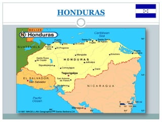
- 1. HONDURAS
- 2. HISTORY Columbus first set foot on the American mainland in Trujillo in 1502 Named the region Honduras (meaning great depth) for the deep water off the coast. The Spaniards soon moved into the cooler highlands and were constantly battling with native tribes, including Chief Lemira's army of 30,000, who almost drove the Spanish out of the region until he was murdered while attending peace talks in 1537. Comayagua (co-my-a-gwa) was declared the Spanish colonial capital a year later. When gold and silver was discovered around Tegucigalpa in 1570, British and Dutch ships began attacking treasure galleons headed out of Trujillo. Pirates settled the Caribbean coast and looted and burned Trujillo in 1643.
- 3. HISTORY (cont) The British established a protectorate along the Caribbean coasts, ostensibly to keep the area free of pirates and protect the native Miskito tribes; but British fortunes were made from the mahogany forests of the region. Honduras broke free from Spain in 1821 and first became part of an independent Mexico. The Honduran Republic was established in 1838, and the British relinquished the Caribbean coastal region in 1859.
- 4. GEOGRAPHY/ENVIRONMENT Honduras is located in Central America, bordering the Caribbean Sea, between Guatemala and Nicaragua and bordering the Gulf of Fonseca (North Pacific Ocean), between El Salvador and Nicaragua Terrain mostly mountains in interior and narrow coastal plains. Natural hazards include: frequent but mild earthquakes and extremely high cases of hurricanes and floods along the Caribbean coast Has only a short Pacific coast but a long Caribbean shoreline, including the virtually uninhabited eastern Mosquito Coast
- 5. ENVIRONMENTAL ISSUES Urban population expanding Deforestation results from logging and the clearing of land for agricultural purposes Further land degradation and soil erosion hastened by uncontrolled development and improper land use practices such as farming of marginal lands Mining activities polluting Lago de Yojoa (the country's largest source of fresh water), as well as several rivers and streams, with heavy metals
- 7. POLITICAL HISTORY Honduran has had several military coups, rebellions, dictatorships, and chess-game politics ever since independence from Spain. Banana power ruled until the 1960s. 1969 Football War Guerrilla warfare surrounds Honduras in the 1980s Rafael Callejas becomes president of Honduras in 1990; refuses to continue a treaty with the United States allowing Honduras to be used as a military base, and the Contras left the country. Without U.S. monetary and political support, most of Honduras' international trade shifted to countries in the European Union. Jose Manuel Zelaya Rosales becomes President Jan. 27, 2006
- 8. US/THEM (2009) HONDURAS CANADA Population: 7,792,854 Population: 33,487,208 Life expectancy at birth: Life expectancy at birth: -total population: 69.4 years -total population: 81.23years -male: 67.86 years -male: 78.69 years -female: 71.02 years -female: 83.91 years HIV/AIDS - adult prevalence rate: 0.7% HIV/AIDS - adult prevalence rate: 0.4% - people living with HIV/AIDS: - people living with HIV/AIDS: 28 000 (2007) 73,000 (2007) -HIV/AIDS - deaths: -HIV/AIDS - deaths: 1900 (2007) fewer than 500 (2007) Government: democratic constitutional republic Government: constitutional monarchy that is Capital City: Tegucigalpa, pop: aprox 1,324,000 also a parliamentary democracy and a federation Flag description: Capital City: Ottawa, pop: aprox 812 000 three equal horizontal bands of blue (top), white, and blue Flag description: with five blue, five-pointed stars arranged in an X pattern two vertical bands of red,with white square centered in the white band; the stars represent the between them; an 11-pointed red maple leaf is members of the former Federal Republic of Central centered in the white square America - Costa Rica, El Salvador, Guatemala, Honduras, and Nicaragua
- 9. US/THEM (2009) HONDURAS CANADA Economy: Economy: GDP (purchasing power) $28.48 billion GDP (purchasing power):$1.336 trillion (2008) Unemployment rate: 6.1% (2008) (2008) Budget: -revenues: $608.3 billion Unemployment rate: 27.8% (2007) -expenditures: $606 billion (2008) Budget: revenues: $2.628 billion Debt – external: $758.6 billion (June 2007) expenditures: $3.183 billion Agriculture – products: wheat, barley, oilseed, Debt – external: $3.602 billion (Dec 2008) tobacco, fruits, vegetables; dairy Agriculture – products: bananas, coffee, products; forest products; fish citrus; beef; timber; shrimp, tilapia, lobster; Industries: corn, African palm transportation equipment, chemicals, processed and unprocessed minerals, Industries: -sugar, coffee, textiles, clothing, food products, wood and paper wood products products, fish products, petroleum 50.75% of population lives below poverty and natural gas line as of 2004
- 10. TEGUCIGALPA
- 11. Did You Know?? Coastal lowlands are hot and humid with temperatures averaging from 30-38C Belize (British Honduras) is 75kms away across the Bay of Honduras Legal age is 18 Independence Day: September 15, 1821 Honduras was devestated by Hurricane Mitch in 1998 *winds up to 290km/hr *Honduras: 7000 dead, 8300 missing *25” of rain in the first 36 hrs, additional 10” in 6 hrs between Oct 29-31 National Currency is Lempira 15 L= $1 CDN
- 12. Did You Know?? Crime is one of Honduras’ major concern; street crimes including purse snatching, pickpocketing, assault and arm robberies are on the rise. Carjackings, kidnappings, muggings and sexual assaults are not uncommon. Poverty, gangs, low apprehension and conviction rates of criminals contribute to a high crime rate. Many men in Honduras carry firearms and machetes, and disputes are sometimes settled with violence. There are problems with the judicial system including an acute shortage of trained personnel, equipment, staff, financial resources and reports of corruption Unmarked mine fields are located on both sides of the Honduras- Nicaragua border and in the area near the Atlantic Coast. Landslides and floods resulting from Hurricane Mitch have scattered many of the remaining mines, making the border area unsafe.
- 13. IT IS RECOMMENDED... That you do not approach children or women since many people in Honduras fear that children are being kidnapped for adoption or for theft of vital organs!! That you prepare your routes before setting out and avoid studying your map in the street as you will be broadcasting the fact that you don’t know where you are. That you avoid clothing that declares your nationality or political beliefs You carry money in small denominations at all times, so you have change for the taxi bill and don’t need a large note where you may not receive change. That you do not take photographs of government or military installations, and antiques purchases are frequent cause of detention by local authorities.
- 14. BIBLIOGRAPHY INFORMATION: The World Fact Book Honduras- https://www.cia.gov/library/publications/the-world-factbook/geos/ho.html The World Fact Book Canada- https://www.cia.gov/library/publications/the-world-factbook/geos/ca.html Travax En Compass- http://www.travax.com/reportgen/report.asp Country of Honduras tourist board www.honduras.com Online Information Guide to Honduras; Metrotel Express, Tegucigalpa, history of Honduras http://www.honduras-information.hotelhonduras.com/Tegucigalpa.html http://www.honduras-information.hotelhonduras.com/Honduras-History.htm PICTURES: South American Experience http://www.southamericanexperience.co.uk/honduras/honduras_roatan.html Destination 360 http://www.destination360.com/central-america/honduras/airlines-to-honduras.php BBC World Service http://www.bbc.co.uk/worldservice/specials/1535_City_Secrets3/page5.html