Recommended
PDF
PDF
6 олон хугацааны хд-ын мэдээгээр бэлчээрийн мониторинг хийх нь - м.эрдэнэтуяа
PDF
9 ойн судалгаанд зтс-г ашиглах нь - з.нарангэрэл
PPTX
PDF
3 байгаль орчны тандан судалгааны өнөөгийн хөгжил, хэтийн зорилт - с.хөдөлмөр
PPT
Land cover changes studies
PDF
15 шороон шуурганы мониторинг - л.очирхуяг
PDF
13 зтс-ны боловсрол сургалт - р.цолмон
PPT
PPTX
PDF
PDF
11 газар тариалангийн бүс дэх хөрсний чийг, хур тундасны хамаарал - д.булган
PPTX
Geomeeting lews ea_june_2015
PDF
PPT
PPT
PPTX
PPTX
ODP
PPTX
PDF
PPTX
PPTX
хиймэл дагуулын мэдээ ашиглан ойн биомассийг тооцох 12 25
PPTX
хиймэл дагуулын мэдээ ашиглан ойн биомассийг тооцох 12 25
PDF
7 байгаль орчны орон зайн мэдээллийн сан - г.батхишиг
PPTX
Buyan nugel-energiin huuli
PDF
2 сансрын цаг уур, байгаль орчны тандан судалгааны хөгжил - ц.адьяасүрэн
PPT
З.Батжаргал "Уур амьсгалын өөрчлөлт, тогтвортой хөгжлийн асуудлууд"
PPTX
PDF
Presentation 20220316 nandia
More Related Content
PDF
PDF
6 олон хугацааны хд-ын мэдээгээр бэлчээрийн мониторинг хийх нь - м.эрдэнэтуяа
PDF
9 ойн судалгаанд зтс-г ашиглах нь - з.нарангэрэл
PPTX
PDF
3 байгаль орчны тандан судалгааны өнөөгийн хөгжил, хэтийн зорилт - с.хөдөлмөр
PPT
Land cover changes studies
PDF
15 шороон шуурганы мониторинг - л.очирхуяг
PDF
13 зтс-ны боловсрол сургалт - р.цолмон
Similar to Gis day rs env applications 20111116
PPT
PPTX
PDF
PDF
11 газар тариалангийн бүс дэх хөрсний чийг, хур тундасны хамаарал - д.булган
PPTX
Geomeeting lews ea_june_2015
PDF
PPT
PPT
PPTX
PPTX
ODP
PPTX
PDF
PPTX
PPTX
хиймэл дагуулын мэдээ ашиглан ойн биомассийг тооцох 12 25
PPTX
хиймэл дагуулын мэдээ ашиглан ойн биомассийг тооцох 12 25
PDF
7 байгаль орчны орон зайн мэдээллийн сан - г.батхишиг
PPTX
Buyan nugel-energiin huuli
PDF
2 сансрын цаг уур, байгаль орчны тандан судалгааны хөгжил - ц.адьяасүрэн
PPT
З.Батжаргал "Уур амьсгалын өөрчлөлт, тогтвортой хөгжлийн асуудлууд"
More from GeoMedeelel
PPTX
PDF
Presentation 20220316 nandia
PDF
Developer community -remote-sensing.pptx
PPTX
PPTX
PPT
PPTX
PDF
PDF
PPTX
PDF
Bayanmunkh geomeeting (1)
PPTX
PDF
Chcnav moblie mapping solution2
PDF
PDF
PPTX
PDF
Demonstration of super map ai gis technology
PDF
Supermap gis 10i(2020) ai gis technology v1.0
PDF
PPTX
Gis day rs env applications 20111116 1. GIS day – 2011
Монгол орны Байгаль орчны салбар дахь
хиймэл дагуулын мэдээний хэрэглээ
М. Эрдэнэтуяа (Ph.D)
БОМТ-ийн ЗТС-ын
тэргүүлэх мэргэжилтэн
Улаанбаатар хот
2011-11- 16
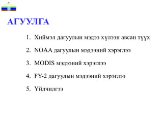
2. АГУУЛГА
1. Хиймэл дагуулын мэдээ хүлээн авсан түүх
2. NOAA дагуулын мэдээний хэрэглээ
3. MODIS мэдээний хэрэглээ
4. FY-2 дагуулын мэдээний хэрэглээ
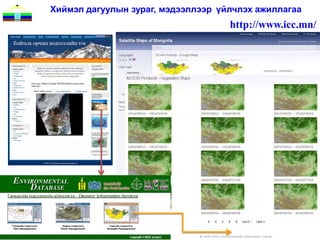
5. Үйлчилгээ
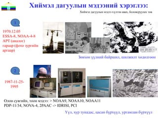
3. Хиймэл дагуулын мэдээний хэрэглээ:
Хиймэл дагуулын мэдээ хүлээн авах, боловсруулах төв
1
1970.12.05
ESSA-8, NOAA-4-8
APT (аналог)
гараар (фото зургийн
аргаар)
Зөвхөн үүлний байршил, шилжилт хөдөлгөөн
2
1987-11-25-
1995
Олон сувгийн, тоон мэдээ: > NOAA9, NOAA10, NOAA11
PDP-11/34, NOVA-4, 2PAAC -> IDRISI, PCI
Үүл, хур тунадас, цасан бүрхүүл, ургамлан бүрхүүл
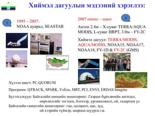
4. Хиймэл дагуулын мэдээний хэрэглээ:
2007 оноос – одоо: 4
3 1995 – 2007:
NOAA цуврал, SEASTAR Антен 2.4м – X-суваг TERRA/AQUA
MODIS, L-суваг HRPT, 3.0м – FY-2C
Хиймэл дагуул: TERRA/MODIS,
AQUA/MODIS, NOAA15, NOAA17,
NOAA18, FY-1D & FY-2C (GMS)
Хүлээн авагч: PC-QUORUM
Программ: QTRACK, SPARK, VxEos, MRT, PCI, ENVI, ERDAS Imagine
Бүтээгдэхүүн: Байгалийн нөөцийн мониторинг: Газрын бүрхэвчийн ангилал,
өөрчлөлтийг тогтоох, бэлчээр, ургамалжилт, ой, гадаргын ус
Байгалийн гамшгийн мониторинг: ган, цөлжилт, цас, зуд,
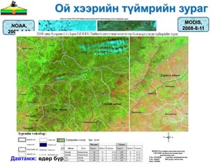
ой хээрийн түймэр, шороон шуурга г.м.
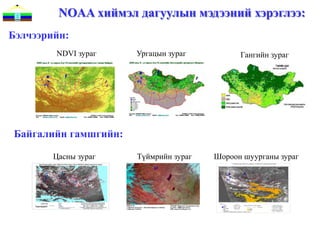
5. NOAA хиймэл дагуулын мэдээний хэрэглээ:
Бэлчээрийн:
NDVI зураг Ургацын зураг Гангийн зураг
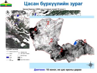
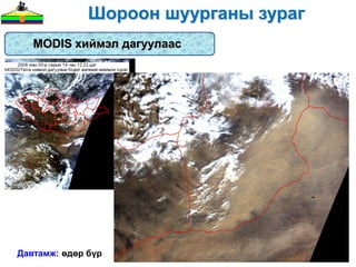
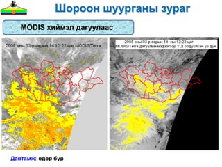
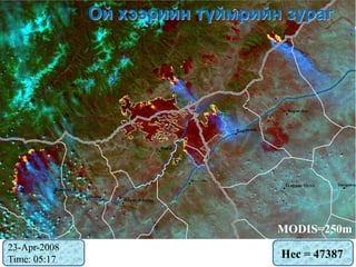
Байгалийн гамшгийн:
Цасны зураг Түймрийн зураг Шороон шуурганы зураг
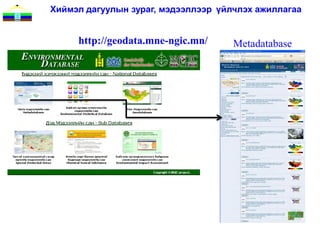
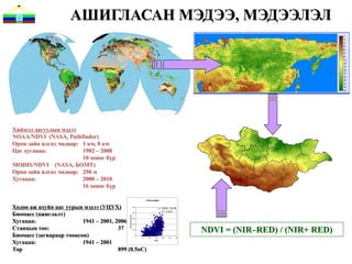
6. АШИГЛАСАН МЭДЭЭ, МЭДЭЭЛЭЛ
Хиймэл дагуулын мэдээ
NOAA/NDVI (NASA, Pathfinder)
Орон зайн ялгах чадвар: 1 км, 8 км
Цаг хугацаа: 1982 – 2008
10 хоног бүр
MODIS/NDVI (NASA, БОМТ)
Орон зайн ялгах чадвар: 250 м
Хугацаа: 2000 – 2010
16 хоног бүр
forest steppe
Хөдөө аж ахуйн цаг уурын мэдээ (УЦУХ) 500
y = 1.2634x - 74.039
Биомасс (ажиглалт)
R2 = 0.3578
400
simulated biomass
Хугацаа:
300
1941 – 2001, 2006 200
Станцын тоо: 37 100
NDVI = (NIR–RED) / (NIR+ RED)
Биомасс (загвараар тооцсон) 0
0 50 100 150 200 250 300
Хугацаа: 1941 – 2001 NDVI
Тор 899 (0.5oC)
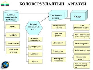
7. БОЛОВСРУУЛАЛТЫН АРГАЗYЙ
Хиймэл Хам боловс-
дагуулын ба Үр дүн
руулалт
ГМС мэдээ
Газрын
Цаг хугацааны NDVI
NOAA ажиглалтын үнэлгээ (Хамгийн их утга)
мэдээ
Орон зайн
MODIS үнэлгээ NDVI-ийн үнэлгээ
(байгалийн мужаар)
Агаарын
температур
ASTER-GDEM Давхцуулах RSDI-ийн үнэлгээ
Хур тунадас
ГМС-ийн
Харьцуулах NDDI-ийн үнэлгээ
зургууд
Биомасс
Биомассын
Хамаарлыг үнэлгээ
Бусад тооцоолох
Цас, ган, түймэр,
Шороон шуурга
г.м
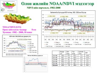
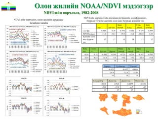
8. Олон жилийн NOAA/NDVI мэдээгээр
NDVI-ийн өөрчлөлт, 1982-2008
NOAA/NDVI (GVI)
Орон зайн ялгах чадвар: 8 км
Хугацаа: 1982 – 2008, 10 хоног
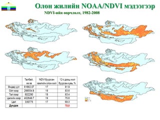
9. 10. Олон жилийн NOAA/NDVI мэдээгээр
NDVI-ийн өөрчлөлт, 1982-2008
NDVI-ийн өөрчлөлтийн шугаман регрессийн а коэффициент,
NDVI-ийн өөрчлөлт, олон жилийн дунджаас буурсан утга ба хамгийн олон жил буурсан жилийн тоо
хазайсан хазайц
Баян Говь- Баян
Увс Зав-хан Өлгий Ховд Алтай хонгор
а коэфф -0.505 -0.38 -0.704 -0.601 -0.439 -0.309
NDVI бууралт -13.6 -10.3 -19.0 -16.2 -11.84 -8.33
Хамгийн олон
жил буурсан 17 17 19 18 17 17
тоо
Хөвс Сэлэн- Өвөр Ар Эрдэ
гөл гэ Бул ган Дархан хангай хангай нэт Төв
-0.19 -0.32 -0.593 -0.195 -0.725 -0.716 -0.587 -0.703
-5.14 -8.67 -16.0 -5.3 -19.6 -19.3 -15.8 -19.0
17 18 18 16 16 16 15 17
Дорнод Сүхбаатар Хэнтий
-0.923 -0.657 -0.8014
-24.9 -12.6 -21.64
18 18 18
Говьсүмбэр Дундговь Дорноговь Өмнөговь
-1.0448 -0.562 -0.2475 -0.3286
-28.2 -15.2 -6.7 -8.9
15 17 17 17
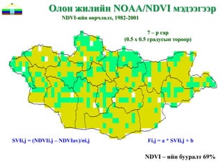
11. Олон жилийн NOAA/NDVI мэдээгээр
NDVI-ийн өөрчлөлт, 1982-2001
7 – р сар
(0.5 х 0.5 градусын тороор)
SVIi,j = (NDVIi.j – NDVIav)/σi,j Fi,j = a * SVIi,j + b
NDVI – ийн бууралт 69%
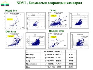
12. NDVI - биомассын хоорондын хамаарал
Өндөр уул Хээр
Áèî ì àññ, ã NDVI áà áèî ì àññû í õàì ààðàë
Áèî ì àññ, ã 25 steppe
Хээр
NDVI áà áèî ì àññû í õàì ààðàë Altai mountains (Õýýðèéí á¿ñýýð)
2.5
(ª í äº ð óóëû í á¿ñýýð) Алтайн y = 0.8837x - 41.981
2 З
200 уулархаг R = 0.3727
20 y = 0.0906x - 11.576
а 500
2
R = 0.3656 y = 1.1502x - 68.182
г
2.0
З 160 400 R2 = 0.3603
а 15 в
simulated biomass
simulated biomass
y = 0.0359x - 4.4693
1.5 2
R = 0.2229 г 120 а 300
в 10
р 200
1.0 а
80
б
р 40
5
и 100
0.5 б NDVI о 0
и 0
0
120 140 160 180 200 220 240
м 0 50 100 150 200 250 300
NDVI о
0 40 80 120 160 200
а NDVI
с
0.0 NDVI
м
-5
120 130 140 150 160 170
а с
Ойт хээр с Цөлийн хээр с
Áèî ì àññ, ã
NDVI áà áèî ì àññû í õàì ààðàë forest steppe NDVI áà áèî ì àññû í õàì ààðàë Gobi desert
Цөлийн хээр
Ойт
14 8
(Î éò õýýðèéí á¿ñýýð) (Öº ëèéí õýýðèéí á¿ñýýð)
12 y = 0.0962x - 13.477 7 З
хээр
500 100
y = 1.2634x - 74.039
а
2
y = 0.3031x - 9.9769
З
R = 0.4936 y = 0.0652x - 7.7694
90
R2 = 0.3578
2
10 6 R = 0.3277 R2 = 0.2022
400
г 80
а
simulated biomass
simulated biomass
в
5 70
8
300 60
а
6
г 200
4
р
50
40
в
3
б
4 30
100 20
2
и
а
2 10
0
1
NDVI о 0
р
0 0 50 100 150 200 250 300 0 50 100 150 200
120 140 160 180 200 220 240 NDVI м NDVI
0
-2
а
б
120 140 160 180 200
с
и с
о
Регрессийн тэгшитгэл r с
м
Ойт хээр y = 0.0962x - 13.477 0.702
а
Өндөр уул
с y = 0.0359x - 4.4693 0.451
с
Хээр
с
y = 0.0906x - 11.576 0.605
Цөлийн хээр y = 0.0652x - 7.7694 0.572
Цөл y = 0.01401x – 1.793 0.694
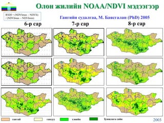
13. 14. Олон жилийн NOAA/NDVI мэдээгээр
RSDI = (NDVImax – NDVIi)
/ (NDVImax – NDVImin) Гангийн судалгаа, М. Баясгалан (PhD) 2005
6-р сар 7-р сар 8-р сар
гантай гандуу хэвийн Зуншлага сайн 2003
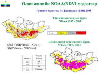
15. Олон жилийн NOAA/NDVI мэдээгээр
Гангийн судалгаа, М. Баясгалан (PhD) 2005
Гангийн давтагдлын зураг,
NOAA 1982 - 2003
<5 жил 6-11жил 11-15 жил >15 жил
Цөлжилтийн эрчимшлийн зураг,
RSDI = (NDVImax – NDVIi) NOAA, 1982 - 2003
/ (NDVImax – NDVImin)
Öº ëæèëòèéí
Òàëáàé, % ýð÷èì ø èë
Áàãà
23.1
Äóí ä
22.7
Èõ
5.1
Öº ëæèëòã¿é
49.1
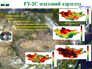
16. FY-2C мэдээний хэрэглээ оноос
2007
1 цаг тутмын мэдээ
ЭУБМС--->
Үндсэн бүтээгдэхүүн--->
Нийлбэр цацраг, в/м2
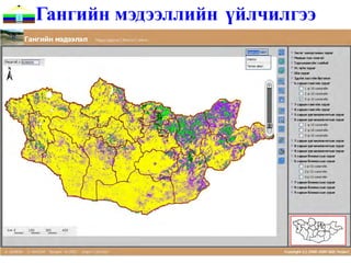
Гангийн мониторингийн систем
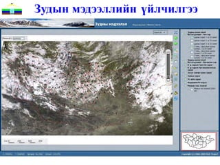
Бэлчээрийн мониторингийн систем
Өвлийн мониторингийн систем
2 м-ийн өндөр дэх температур, C
Хур тунадас, мм
Бодит ууршиц, мм/өдөр
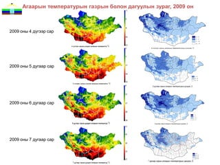
17. Агаарын температурын газрын болон дагуулын зураг, 2009 он
2009 оны 4 дүгээр сар
2009 оны 5 дугаар сар
2009 оны 6 дугаар сар
2009 оны 7 дугаар сар
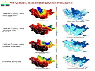
18. Хур тунадасны газрын болон дагуулын зураг, 2009 он
2009 оны 6 дугаар сарын
эхний арав хоног
2009 оны 6 дугаар сарын
дунд арав хоног
2009 оны 6 дугаар сарын
сүүлчийн арав хоног
2009 оны 6 дугаар сар
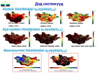
19. Дэд системүүд
Ãàíãèéí ìîíèòîðèíãèéí á¿òýýãäýõ¿¿í
Óóð àìüñãàëûí ÷èéãèéí Õºðñíèé ÷èéãèéí Óóðøèöûí ãàíãèéí
èíäåêñ, ìì/ºäºð èíäåêñ, ìì/ºäºð èíäåêñ, ìì/ºäºð
Áýë÷ýýðèéí ìîíèòîðèíãèéí á¿òýýãäýõ¿¿í
Áîäèò óðãàö, êã/ãà Áèîìàññûí èäýãäýö, êã/ãà Áýë÷ýýðèéí äààö, õîíèí òîëãîé/ãà
Өвөлжилтèéí ìîíèòîðèíãèéí á¿òýýãäýõ¿¿í
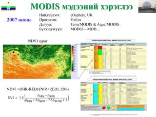
20. MODIS мэдээний хэрэглээ
Нийлүүлэгч: eOsphere, UK
2007 оноос Программ: VxEos
Дагуул: Terra/MODIS & Aqua/MODIS
Бүтээгдэхүүн: MOD03 – MOD…
NDVI зураг
NDVI =(NIR-RED)/(NIR+RED), 250м
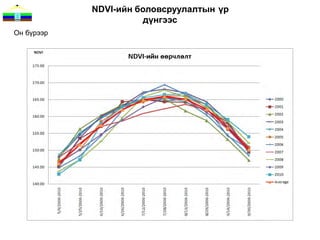
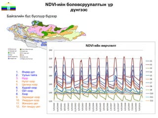
21. 22. 23. NDVI-ийн боловсруулалтын үр
дүнгээс
Байгалийн бүс бүслүүр бүрээр
1. Өндөр уул
2. Уулын тайга
3. Нуур
4. Нугат хээр
5. Цөлжүү хээр
6. Хуурай хээр
7. Ойт хээр
8. Хээр
9. Заримдаг хээр
10. Умардын хээр
11. Жинхэнэ цөл
12. Хэт гандуу цөл
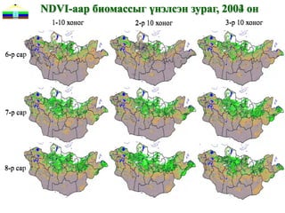
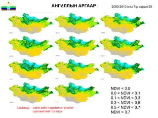
24. АНГИЛЛЫН АРГААР 2000-2010 оны 7-р сарын 28
NDVI < 0.0
0.0 < NDVI < 0.1
0.1 < NDVI < 0.3
0.3 < NDVI < 0.5
Цаашид: орон зайн тархалтыг үнэлэх 0.5 < NDVI < 0.7
шилжилтийг тогтоох NDVI > 0.7
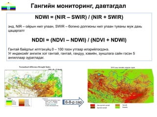
25. Гангийн мониторинг, давтагдал
NDWI = (NIR – SWIR) / (NIR + SWIR)
энд, NIR – ойрын нил улаан, SWIR – богино долгионы нил улаан туяаны муж дахь
цацаргалт
NDDI = (NDVI – NDWI) / (NDVI + NDWI)
Гантай байдлыг илтгэхүйц 0 – 100 тоон утгаар илэрийлэгдэнэ.
Уг индексийг ангилж хэт гантай, гантай, гандуу, хэвийн, зуншлага сайн гэсэн 5
ангиллаар зурагладаг.
6-8-р сар
26. Ургацын үнэлгээ
MODIS/NPP 1 жилийн мэдээ
Ургамлан нөмрөгийн ургацыг ургамлын фотосинтезийн үзүүлэлтийг
оролцуулан үнэлдэг учраас энэхүү бүтээгдэхүүнийг тооцоолохдоо
дэлхийн хэмжээнд газрын доройтол, ц өлжилтийг үнэлдэг GLADA аргад
тооцоолсон дараахь томъёогоор тооцоолно.
NPPMOD17 = 1106.37 * sum NDVI – 564.55 [kgC ha-1 year-1]
(r = 0.83, n = 3128207)
Энд, NPPMOD17 – MODIS MOD17 бүтээгдэхүүнээс гарган авсан NPP, sum
NDVI – GIMMS-ээс авсан олон жилийн дундажийн нийлбэр NDVI
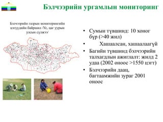
27. Бэлчээрийн ургамлын мониторинг
Бэлчээрийн газрын мониторингийн
цэгүүдийн байршил /Ус, цаг уурын
улсын сүлжээ/ • Сумын түвшинд: 10 хоног
бүр (>40 жил)
• Хашаалсан, хашаалаагүй
• Багийн түвшинд бэлчээрийн
талхагдлын ажиглалт: жилд 2
удаа (2002 оноос >1550 цэгт)
• Бэлчээрийн даац,
багтаамжийн зураг 2001
оноос
28. УРГАЦЫН ҮНЭЛГЭЭ
MODIS/NDVI ба ургац
Бэлчээрийн мониторингийн улсын с үлжээнд ургацыг хэмждэг аргазүйгээр
хийсэн ургацын 2008-2010 оны мэдээг УЦУХ-ээс авч MODIS/NDVI мэдээтэй
харьцуулан, хамаарлыг тооцоолж дараахь 2-р зэргийн полиномаль
тэгшитгэлийг гаргасан.
Ургац = 13.61 * NDVI2 – 0.088 * NDVI + 0.6563 [ц/гa]
r = 0.61, n = 3770
29. 30. 31. 32. 33. 34. 35. 36. 37. 38. 39.


![Ургацын үнэлгээ
MODIS/NPP 1 жилийн мэдээ
Ургамлан нөмрөгийн ургацыг ургамлын фотосинтезийн үзүүлэлтийг
оролцуулан үнэлдэг учраас энэхүү бүтээгдэхүүнийг тооцоолохдоо
дэлхийн хэмжээнд газрын доройтол, ц өлжилтийг үнэлдэг GLADA аргад
тооцоолсон дараахь томъёогоор тооцоолно.
NPPMOD17 = 1106.37 * sum NDVI – 564.55 [kgC ha-1 year-1]
(r = 0.83, n = 3128207)
Энд, NPPMOD17 – MODIS MOD17 бүтээгдэхүүнээс гарган авсан NPP, sum
NDVI – GIMMS-ээс авсан олон жилийн дундажийн нийлбэр NDVI](https://image.slidesharecdn.com/gisdayrsenv-applications20111116-111202010913-phpapp02/85/Gis-day-rs-env-applications-20111116-26-320.jpg)
![УРГАЦЫН ҮНЭЛГЭЭ
MODIS/NDVI ба ургац
Бэлчээрийн мониторингийн улсын с үлжээнд ургацыг хэмждэг аргазүйгээр
хийсэн ургацын 2008-2010 оны мэдээг УЦУХ-ээс авч MODIS/NDVI мэдээтэй
харьцуулан, хамаарлыг тооцоолж дараахь 2-р зэргийн полиномаль
тэгшитгэлийг гаргасан.
Ургац = 13.61 * NDVI2 – 0.088 * NDVI + 0.6563 [ц/гa]
r = 0.61, n = 3770](https://image.slidesharecdn.com/gisdayrsenv-applications20111116-111202010913-phpapp02/85/Gis-day-rs-env-applications-20111116-28-320.jpg)