Download free for 30 days
Sign in
Upload
Language (EN)
Support
Business
Mobile
Social Media
Marketing
Technology
Art & Photos
Career
Design
Education
Presentations & Public Speaking
Government & Nonprofit
Healthcare
Internet
Law
Leadership & Management
Automotive
Engineering
Software
Recruiting & HR
Retail
Sales
Services
Science
Small Business & Entrepreneurship
Food
Environment
Economy & Finance
Data & Analytics
Investor Relations
Sports
Spiritual
News & Politics
Travel
Self Improvement
Real Estate
Entertainment & Humor
Health & Medicine
Devices & Hardware
Lifestyle
Change Language
Language
English
Español
Português
Français
Deutsche
Cancel
Save
Submit search
EN
Uploaded by
Praewful
809 views
Gis
Read more
0
Save
Share
Embed
Embed presentation
Download
Downloaded 12 times
1
/ 11
2
/ 11
3
/ 11
4
/ 11
5
/ 11
6
/ 11
7
/ 11
8
/ 11
9
/ 11
10
/ 11
11
/ 11
More Related Content
PDF
Bangladesh
by
FAO
PPT
Status and Perspectives of GIS Application in BANGLADESH
by
Bayes Ahmed
PPTX
Soil Pollution: A Hidden Reality
by
Chandrani Goswami
PPTX
Impact of global climate change on agriculture A Presentation by Mr Allah Da...
by
Mr.Allah Dad Khan
PDF
Regional Planning Notes
by
Yash Shah
PDF
Application Of GIS In Environmental Engineering
by
Stephen Faucher
PPT
River bank erosion in bangladesh
by
Md Asif Hasan
PDF
Sustainable Water Management in Cascade System: A model in Environmentally Se...
by
Dr. P.B.Dharmasena
Bangladesh
by
FAO
Status and Perspectives of GIS Application in BANGLADESH
by
Bayes Ahmed
Soil Pollution: A Hidden Reality
by
Chandrani Goswami
Impact of global climate change on agriculture A Presentation by Mr Allah Da...
by
Mr.Allah Dad Khan
Regional Planning Notes
by
Yash Shah
Application Of GIS In Environmental Engineering
by
Stephen Faucher
River bank erosion in bangladesh
by
Md Asif Hasan
Sustainable Water Management in Cascade System: A model in Environmentally Se...
by
Dr. P.B.Dharmasena
What's hot
PPT
PCBs and PAHs
by
Abubakar A Musa
PPTX
Final Year Project Proposal-Water purification System
by
Wickramarathne GT
PPTX
NATURAL AND ANTHAOPOGENIC RADIATIVE FORCING BASED ON IPCC AR5
by
Anakha Mohan
PPTX
GIS Modeling
by
John Reiser
PDF
Iha, sap, methods and models of eia
by
jeet707
PPTX
URBAN ECOSYSTEM.pptx
by
MargieBAlmoza
PPT
Carbon sequestration
by
Samuel Trinity
PPT
Methodology for Preparation of Master Plan
by
JIT KUMAR GUPTA
PPTX
French School of Geographical Thoughts [Autosaved].pptx
by
fuadrh420
PPTX
Structure of atmosphere
by
gopinathannsriramachandraeduin
PDF
Landslide and Its Impact on Hilly Region of Bangladesh
by
RituSaha3
PPT
Green house gases & effects
by
Maulana Abul Kalam Azad University of Technology
PCBs and PAHs
by
Abubakar A Musa
Final Year Project Proposal-Water purification System
by
Wickramarathne GT
NATURAL AND ANTHAOPOGENIC RADIATIVE FORCING BASED ON IPCC AR5
by
Anakha Mohan
GIS Modeling
by
John Reiser
Iha, sap, methods and models of eia
by
jeet707
URBAN ECOSYSTEM.pptx
by
MargieBAlmoza
Carbon sequestration
by
Samuel Trinity
Methodology for Preparation of Master Plan
by
JIT KUMAR GUPTA
French School of Geographical Thoughts [Autosaved].pptx
by
fuadrh420
Structure of atmosphere
by
gopinathannsriramachandraeduin
Landslide and Its Impact on Hilly Region of Bangladesh
by
RituSaha3
Green house gases & effects
by
Maulana Abul Kalam Azad University of Technology
Similar to Gis
PDF
ระบบสารสนเทศภูมิศาสตร์
by
PraewfulWonderwonder WonderfulWonderwonder
PDF
Knownledge Gis
by
tanakorntanat
PPT
GIS Presentation
by
Athiwat Phinyoyang
PPT
What Is GIS?
by
Prapaporn Boonplord
PDF
ใบความรู้ระบบสารสนเทศทางภูมิศาสตร์
by
krunimsocial
PPT
What is GIS
by
IT for Society Club
PDF
First Week
by
wirotela
PDF
Lecture 01GIS
by
โรงเรียนนารีนุกูล 2
PDF
Ogctaxmap
by
Ayutthaya GIS
PDF
Map windowgismanual
by
Attaporn Ninsuwan
PDF
Syllabus 832373
by
wirotela
PPTX
ระบบสารสนเทศ
by
khanidthakpt
PDF
เทคโนโลยีการสำรวจด้านธรณีวิทยา โยธาสาร23
by
Theera Laphitchayangkul
PPT
Spat Db 1 Intro Spat Rdbms
by
phisan_chula
PDF
SMMS 53 R S Software
by
Sunt Uttayarath
PDF
เทคโนโลยีสารสนเทศ Work3-39
by
Thamonwan Phasopbuchatham
PDF
10 Conclusion
by
Sarit Tiyawongsuwan
PDF
หลักการเบื้องต้นการรับรู้จากระยะไกล บทที่ 1
by
KruNistha Akkho
PPT
Eis presentation
by
pimpatcha
PPT
Example of gis&rs applications
by
Prapaporn Boonplord
ระบบสารสนเทศภูมิศาสตร์
by
PraewfulWonderwonder WonderfulWonderwonder
Knownledge Gis
by
tanakorntanat
GIS Presentation
by
Athiwat Phinyoyang
What Is GIS?
by
Prapaporn Boonplord
ใบความรู้ระบบสารสนเทศทางภูมิศาสตร์
by
krunimsocial
What is GIS
by
IT for Society Club
First Week
by
wirotela
Lecture 01GIS
by
โรงเรียนนารีนุกูล 2
Ogctaxmap
by
Ayutthaya GIS
Map windowgismanual
by
Attaporn Ninsuwan
Syllabus 832373
by
wirotela
ระบบสารสนเทศ
by
khanidthakpt
เทคโนโลยีการสำรวจด้านธรณีวิทยา โยธาสาร23
by
Theera Laphitchayangkul
Spat Db 1 Intro Spat Rdbms
by
phisan_chula
SMMS 53 R S Software
by
Sunt Uttayarath
เทคโนโลยีสารสนเทศ Work3-39
by
Thamonwan Phasopbuchatham
10 Conclusion
by
Sarit Tiyawongsuwan
หลักการเบื้องต้นการรับรู้จากระยะไกล บทที่ 1
by
KruNistha Akkho
Eis presentation
by
pimpatcha
Example of gis&rs applications
by
Prapaporn Boonplord
Gis
1.
ระบบสารสนเทศภูมิศาสตร์
Geographic Information System: GIS โดยนางสาวธิดารัตน์ สุวรรณพันธ์ มหาวิทยาลัยเกษตรศาสตร์ วิทยาเขตเฉลิมพระเกียรติจังหวัดสกลนคร ในอดีตที่ผ่านมาในการจัดทาแผนที่ของมนุ ษย์น้ันได้ ใช้ การวาดลายเส้ น และเติมตัวอักษร รวมถึงสัญลักษณ์ และสี ลงบนผ้ า หรือกระดาษ ได้ ออกมาเป็ นแผนที่ท่ีสามารถนาไปใช้ ในการ เดินทางสารวจ หรือ การคมนาคมติดต่อ ค้ าขายระหว่างกัน โดยกาหนดทิศทางตามทิศเหนือ และ มาตราส่วน ก็ใช้ เทคโนโลยีพ้ ืนฐานในสมัยยุคแรกคือการเดินนับก้ าว แล้ วนาระยะทางจริงบนโลก มาย่อลงบนกระดาษหรื อผ้ าที่จัดทาแผนที่ ปั ญหาที่เกิดขึ้นคือ ในการจัดทาแผนที่ชุดเดียวกันนั้น จะต้ องมีการสาเนาหรือ คัดลอกโดยการนากระดาษ หรือ ผ้ าอีกชุดหนึ่งมาวางทาบแล้ วลอกลาย ที่ได้ ทาไว้ อาจเกิดการผิดพลาดในเรื่องตาแหน่ งที่ต้ังของสถานที่ ตลอดจนถนนหรื อเส้ นทางที่ คลาดเคลื่ อนได้ เสมอ เพราะขึ้น อยู่ กับ ความสามารถของบุ คคลที่ทาการคัดลอก นอกจากนี้ การแก้ ไขข้ อมู ลตัวอักษร หรื อสัญลั กษณ์อ่ ืนๆ ทาได้ ยากมาก เพราะการแก้ ไขอาจทาให้ แผนที่ ช ารุ ด ได้ และในยุ ค ต่ อ ๆมา มี ก ารพั ฒ นาเทคโนโลยี ต่ า งๆเข้ ามาอ านวยความสะดวกใน ชีวิตประจาวัน ซึ่งเทคโนโลยีเหล่านั้นได้ อานวยความสะดวกและรวดเร็วในการผลิตแผนที่มากขึ้น ความพยายามในการพัฒนาเทคโนโลยีเพื่อให้ ง่าย ต่อการจัดทาแผนที่ยังไม่มีท่ส้ นสุด เมื่อีิ องค์ความรู้ทางด้ านเทคโนโลยีคอมพิวเตอร์เข้ ามามีบทบาทมากขึ้นในสังคมปัจจุบัน คอมพิวเตอร์ เข้ ามารับหน้ าที่ช่วยเหลือให้ มนุ ษย์ทางานได้ รวดเร็วขึ้น และสามารถทางานที่ซาซาก หรืองานที่ทา ้ ให้ มนุษย์เกิดความล้ าหรือเบื่อหน่าย คอมพิวเตอร์กจะช่วยให้ งานนั้นทาได้ รวดเร็วขึ้น แต่การ ็ เรียนรู้การใช้ เทคโนโลยีน้ันเป็ นสิ่งที่จาเป็ นต้ องเกิดขึ้นมา ระบบสารสนเทศภูมิศาสตร์ (GIS) ได้ มี การพัฒนาเมื่อตอนต้ นปี ค.ศ. 1960 ด้ วยเทคโนโลยีคอมพิวเตอร์ท่ได้ พัฒนามากขึ้นเพื่อช่วยใน ี การจั ด เก็บ ข้ อมู ล ได้ มากขึ้ น และมี ก ารปรั บ ปรุ ง ประสิ ท ธิ ภ าพในการจั ด เก็บ ข้ อมู ล ในระบบสารสนเทศภูมิศาสตร์ให้ ดีข้ ึน และในการผลิตแผนที่น้ัน การที่ต้องการความถูกต้ อง แม่นยา และสามารถช่ วยตอบคาถามต่างๆ ได้ น้ัน ต้ องอาศัยทักษะในการฝึ กฝน และเรี ยนรู้ เมื่ อ มนุ ษ ย์ น าคอมพิ ว เตอร์ เ ข้ า มาผลิ ต แผนที่ท าให้ ก ารผลิ ต แผนที่เ ริ่ ม เป็ นระบบมากขึ้ น ซึ่ ง ระบบคอมพิวเตอร์ได้ มีส่วนช่วยในการพัฒนาระบบข้ อมูล GIS ทาการรวบรวม จัดเก็บ วิเคราะห์
2.
2 เรียกค้ นข้ อมูล
และการแสดงผลข้ อมูล จึงทาให้ ง่ายต่อการค้ นข้ อมูล และ การประมวลผลข้ อมูล อย่างมีประสิทธิภาพมากขึ้น ระบบสารสนเทศภูมิศาสตร์ หรือ Geographic Information System : GIS คือ กระบวนการทางานเกี่ยวกับข้ อ มู ลในเชิ งพื้ นที่ด้ว ยระบบคอมพิ วเตอร์ ที่ใช้ ก าหนดข้ อ มู ลและ สารสนเทศที่มีความสัมพันธ์กับตาแหน่งในเชิงพื้นที่ เช่น ที่อยู่ บ้ านเลขที่ สัมพันธ์กับตาแหน่งใน แผนที่ ตาแหน่งละติจูด (Latitude) หรือ เส้ นรุ้ง ลองติจูด (Longitude) หรือ เส้ นแวง ข้ อมูลและ แผนที่ใน GIS เป็ นระบบข้ อมูลสารสนเทศที่อยู่ในรูปของตารางข้ อมูล และฐานข้ อมูลที่มส่วนี สัมพันธ์กับข้ อมูล เชิ งพื้ นที่ (Spatial Data) ซึ่ งรูปแบบและความสัมพั นธ์ของข้ อมู ลเชิ งพื้ นที่ ทั้งหลาย จะสามารถนามาวิเคราะห์ด้วย GIS และทาให้ ส่อความหมายในเรื่องการเปลี่ยนแปลงที่ ื สัมพันธ์กับเวลาได้ เช่น การแพร่ ขยายของโรคระบาด การเคลื่อนย้ ายถิ่นฐาน การบุกรุกทาลาย การเปลี่ยนแปลงของการใช้ พ้ ื นที่ ฯลฯ ข้ อมูลเหล่านี้เมื่อปรากฏบนแผนที่ทาให้ สามารถแปลและ สื่อความหมาย ใช้ งานได้ ง่าย GIS เป็ นระบบข้ อ มู ลข่ า วสารที่เก็บไว้ ในคอมพิ วเตอร์ แต่สามารถแปลความหมาย เชื่ อมโยงกับสภาพภูมิศาสตร์ อ่ ืนๆ สภาพท้ องที่ สภาพการทางานของระบบสัมพั นธ์กับสัดส่วน ระยะทางและพื้นที่จริงบนแผนที่ ข้ อแตกต่างระหว่าง GIS กับ MIS นั้นสามารถพิจารณาได้ จาก ลักษณะของข้ อมูล คือ ข้ อมูลที่จัดเก็บใน GIS มีลักษณะเป็ นข้ อมูลเชิงพื้น ที่ ที่แสดงในรูปของ ภาพ (Graphic) แผนที่ (Map) ที่เชื่อมโยงกับข้ อมูลเชิงบรรยาย (Attribute Data) หรือฐานข้ อมูล (Database) การเชื่อมโยงข้ อมูลทั้งสองประเภทเข้ าด้ วยกันจะทาให้ ผ้ ูใช้ สามารถที่จะแสดงข้ อมูลทั้ง สองประเภทได้ พร้ อมๆ กัน เช่ น สามารถจะค้ นหาตาแหน่งของจุ ดตรวจวัดควันดา-ควันขาวได้ โดยการระบุช่ ือจุดตรวจหรือในทางตรงกันข้ าม สามารถที่จะสอบถามรายละเอียดของจุ ดตรวจจาก ตาแหน่งที่เลือกขึ้นมา ซึ่งจะต่างจาก MIS ที่แสดงภาพเพียงอย่างเดียวโดยจะขาดการเชื่อมโยงกับ ฐานข้ อมูลที่เชื่อมโยงกับรูปภาพนั้น เช่น ใน CAD (Computer Aid Design) จะเป็ นภาพเพียง อย่างเดียว แต่แผนที่ใน GIS จะมีความสัมพันธ์กบตาแหน่งในเชิงพื้นที่ทางภูมิศาสตร์ คือ ค่าพิกัด ั ที่แน่นอนข้ อมูลใน GIS ทั้งข้ อมูลเชิงพื้นที่และข้ อมูลเชิงบรรยายสามารถอ้ างอิงถึงตาแหน่งที่มีอยู่ จริ งบนพื้ นโลกได้ โดยอาศัยระบบพิ กัดทางภูมิศาสตร์ (Geocode) ซึ่งจะสามารถอ้ างอิงได้ ท้ัง ทางตรงและทางอ้ อม ข้ อมูลใน GIS ที่อ้างอิงกับพื้ นผิวโลกโดยตรง หมายถึง ข้ อมูลที่มีค่าพิ กัด หรือมีตาแหน่งจริงบนพื้นโลกหรือในแผนที่ เช่น ตาแหน่งอาคาร ถนน ฯลฯ สาหรับข้ อมูล GIS ที่ จะอ้ างอิงกับข้ อมูลบนพื้นโลกได้ โดยทางอ้ อม ได้ แก่ ข้ อมูลของบ้ าน (รวมถึงบ้ านเลขที่ ซอย เขต แขวง จังหวัด และรหัสไปรษณีย์) โดยจากข้ อมูลที่อยู่ เราสามารถทราบได้ ว่าบ้ านหลังนี้มีตาแหน่ง อยู่ ณ ที่ใดบนพื้นโลก เนื่องจากบ้ านทุกหลังจะมีท่อยู่ไม่ซากัน ี ้
3.
3
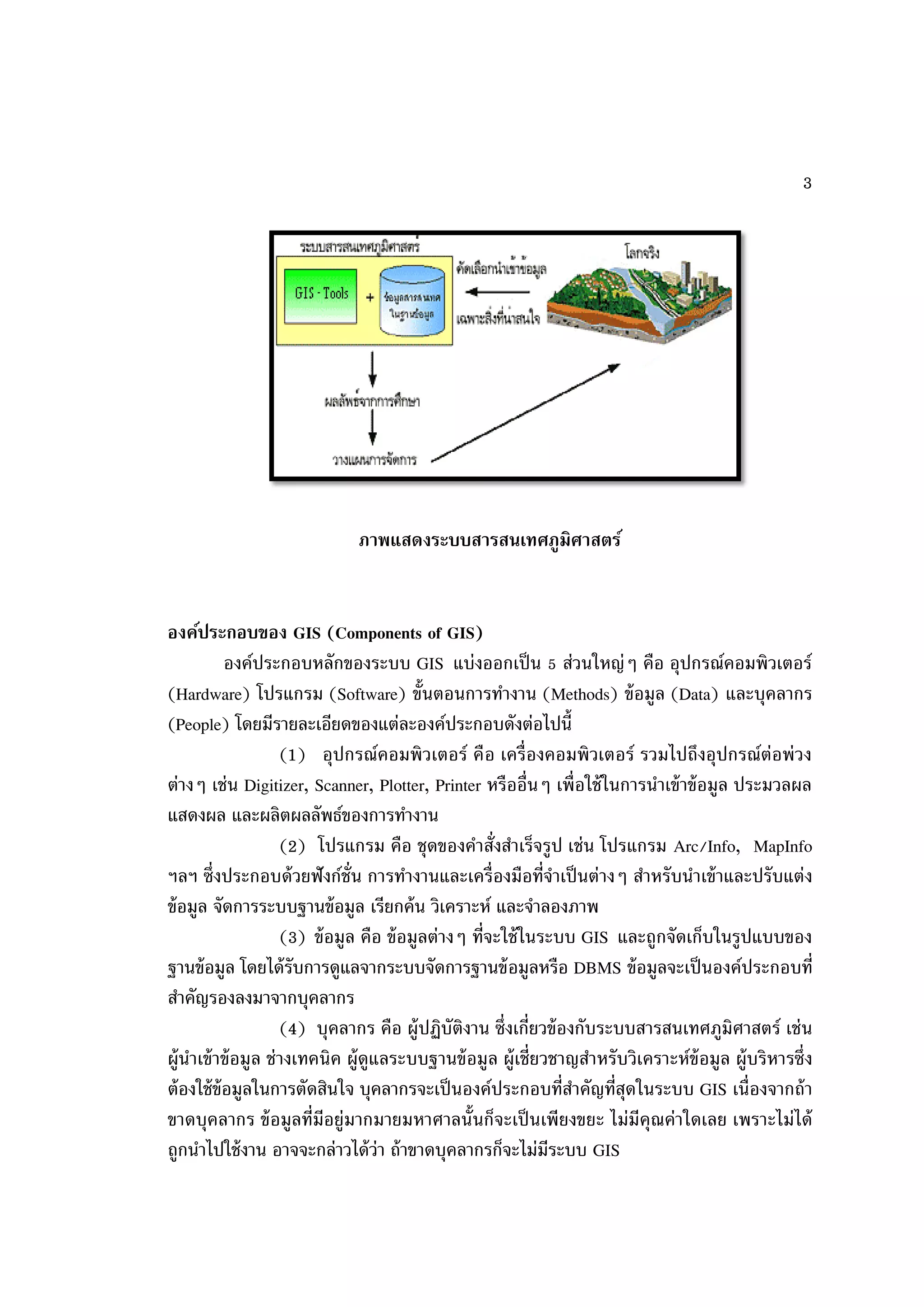
ภาพแสดงระบบสารสนเทศภูมิศาสตร์ องค์ประกอบของ GIS (Components of GIS) องค์ประกอบหลักของระบบ GIS แบ่งออกเป็ น 5 ส่วนใหญ่ๆ คือ อุปกรณ์คอมพิวเตอร์ (Hardware) โปรแกรม (Software) ขั้นตอนการทางาน (Methods) ข้ อมูล (Data) และบุคลากร (People) โดยมีรายละเอียดของแต่ละองค์ประกอบดังต่อไปนี้ (1) อุปกรณ์คอมพิวเตอร์ คือ เครื่องคอมพิวเตอร์ รวมไปถึงอุปกรณ์ต่อพ่ วง ต่างๆ เช่น Digitizer, Scanner, Plotter, Printer หรืออื่นๆ เพื่อใช้ ในการนาเข้ าข้ อมูล ประมวลผล แสดงผล และผลิตผลลัพธ์ของการทางาน (2) โปรแกรม คือ ชุดของคาสั่งสาเร็จรูป เช่น โปรแกรม Arc/Info, MapInfo ฯลฯ ซึ่งประกอบด้ วยฟั งก์ช่ัน การทางานและเครื่องมือที่จาเป็ นต่างๆ สาหรับนาเข้ าและปรับแต่ง ข้ อมูล จัดการระบบฐานข้ อมูล เรียกค้ น วิเคราะห์ และจาลองภาพ (3) ข้ อมูล คือ ข้ อมูลต่างๆ ที่จะใช้ ในระบบ GIS และถูกจัดเก็บในรูปแบบของ ฐานข้ อมูล โดยได้ รับการดูแลจากระบบจัดการฐานข้ อมูลหรือ DBMS ข้ อมูลจะเป็ นองค์ประกอบที่ สาคัญรองลงมาจากบุคลากร (4) บุคลากร คือ ผู้ปฏิบัติงาน ซึ่งเกี่ยวข้ องกับระบบสารสนเทศภูมิศาสตร์ เช่ น ผู้นาเข้ าข้ อมูล ช่ างเทคนิค ผู้ดูแลระบบฐานข้ อมูล ผู้เชี่ยวชาญสาหรับวิเคราะห์ข้อมูล ผู้บริหารซึ่ง ต้ องใช้ ข้อมูลในการตัดสินใจ บุคลากรจะเป็ นองค์ประกอบที่สาคัญที่สดในระบบ GIS เนื่องจากถ้ า ุ ขาดบุคลากร ข้ อมูลที่มีอยู่มากมายมหาศาลนั้นก็จะเป็ นเพี ยงขยะ ไม่มีคุณค่าใดเลย เพราะไม่ได้ ถูกนาไปใช้ งาน อาจจะกล่าวได้ ว่า ถ้ าขาดบุคลากรก็จะไม่มีระบบ GIS
4.
4
(5) วิธีการหรือขั้นตอนการทางาน คือ วิ ธีการที่องค์กรนั้นๆ นาเอาระบบ GIS ไปใช้ งาน โดยแต่ละระบบแต่ละองค์กรย่อมมีความแตกต่างกันออกไป ฉะนั้นผู้ปฏิบัติงานต้ อง เ ลื อ ก วิ ธี ก า ร ใ น ก า ร จั ด ก า ร กั บ ปั ญ ห า ที่ เ ห ม า ะ ส ม ที่ สุ ด ส า ห รั บ ห น่ ว ย ง า น นั้ น ๆ การทางานของระบบสารสนเทศภูมิศาสตร์ (GIS Operation System) ระบบ GIS (Geographic Information System) ควรจะต้ องมีความสามารถพื้นฐาน 6 ประการ เพื่อช่วยในการแก้ ไขจากพื้นโลกจริง ประกอบด้ วย (1) การรวบรวมข้ อมูล (Capture data) (2) การจัดเก็บข้ อมูล (Storing data) (3) การสืบค้ นข้ อมูล (Querying data) (4) การวิเคราะห์ข้อมูล (Analyzing data) (5) การแสดงผลข้ อมูล (Displaying data) (6) การสร้ างผลงานจากข้ อมูล (Outputting data) หน้าทีของระบบภูมิศาสตร์สารสนเทศ ่ หน้ าที่ของ GIS (How GIS Works) หน้ าที่หลักๆ มีอยู่ด้วยกัน 5 อย่าง ดังนี้ (1) การนาเข้ าข้ อมูล (Input) ก่อนที่ข้อมูลทางภูมิศาสตร์จะถูกใช้ งานได้ ในระบบ สารสนเทศภูมิศาสตร์ ข้ อมูลจะต้ องได้ รับการแปลงให้ มาอยู่ในรูปแบบของข้ อมูลเชิงตัวเลข (2) การปรั บแต่งข้ อมูล (Manipulation) ข้ อมู ลที่ได้ รั บเข้ าสู่ระบบบางอย่ า ง จาเป็ นต้ องได้ รับการปรับแต่งให้ เหมาะสมกับงาน เช่น ข้ อมูลบางอย่างมีขนาดหรือสเกล (scale) ที่แ ตกต่ า งกันหรื อ ใช้ ระบบพิ กัดแผนที่ท่ีแ ตกต่ า งกัน ข้ อมู ลเหล่ านี้ จะต้ องได้ รับ การปรั บ ให้ อ ยู่ ในระดับเดียวกัน (3) การบริหารข้ อมูล (Management) ระบบจัดการฐานข้ อมูลหรือ DBMS จะ ถูกนามาใช้ ในการบริหารข้ อมูลเพื่ อการทางานที่มีประสิทธิภาพในระบบ GIS DBMS ที่ได้ รับการ เชื่ อถื อและนิ ยมใช้ กันอย่ างกว้ างขวางที่สุดคื อ DBMS แบบ Relational หรื อระบบจั ดการ ฐานข้ อมูลแบบสัมพัทธ์ (DBMS) ซึ่งมีหลักการทางานพื้นฐาน คือข้ อมูลจะถูกจัดเก็บในรูปของ ตารางหลายๆ ตาราง (4) การเรียกค้ นและวิเคราะห์ข้อมูล (Query and Analysis) เมื่อระบบ GIS มี ความพร้ อมในเรื่องของข้ อมูลแล้ วขั้นตอนต่อไปคือการนาข้ อมูลเหล่านี่มาใช้ ให้ เกิดประโยชน์ เช่น ใครคือเจ้ าของกรรมสิทธิ์ในที่ดินผืนที่ติดกับโรงเรี ยน เมืองสองเมืองนี้มีระยะห่ างกันกี่กิโลเมตร ดิ น ชนิ ด ใดบ้ า งที่เ หมาะส าหรั บ ปลู ก อ้ อ ย หรื อ ต้ อ งมี ก ารสอบถามอย่ า งง่ า ยๆ เช่ น ชี้ เมาส์ไ ป
5.
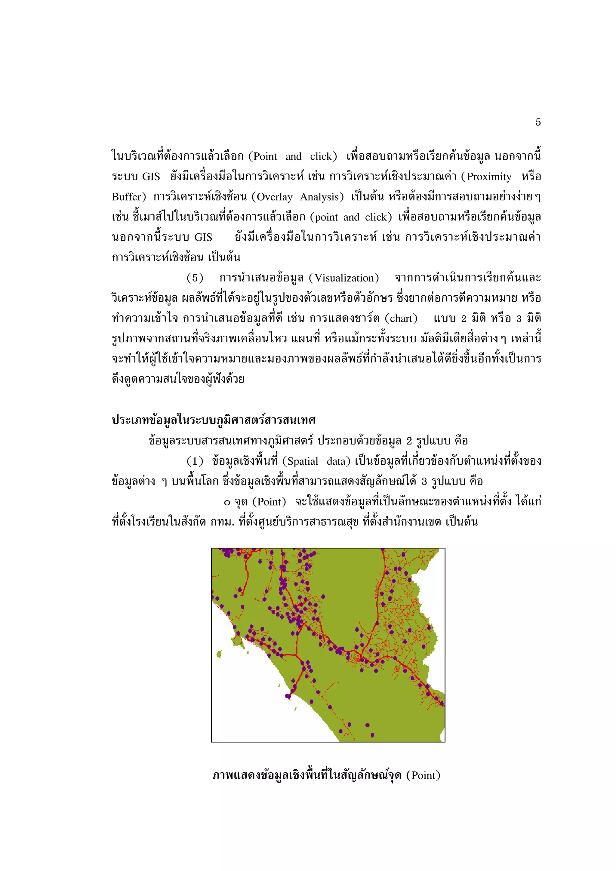
5 ในบริเวณที่ต้องการแล้ วเลือก (Point
and click) เพื่อสอบถามหรือเรียกค้ นข้ อมูล นอกจากนี้ ระบบ GIS ยังมีเครื่องมือในการวิเคราะห์ เช่น การวิเคราะห์เชิงประมาณค่า (Proximity หรือ Buffer) การวิเคราะห์เชิงซ้ อน (Overlay Analysis) เป็ นต้ น หรือต้ องมีการสอบถามอย่างง่ายๆ เช่น ชี้เมาส์ไปในบริเวณที่ต้องการแล้ วเลือก (point and click) เพื่อสอบถามหรือเรียกค้ นข้ อมูล นอกจากนี้ ระบบ GIS ยั ง มีเ ครื่ อ งมื อ ในการวิ เ คราะห์ เช่ น การวิ เ คราะห์ เ ชิ ง ประมาณค่ า การวิเคราะห์เชิงซ้ อน เป็ นต้ น (5) การน าเสนอข้ อมูล (Visualization) จากการดาเนินการเรี ยกค้ นและ วิเคราะห์ข้อมูล ผลลัพธ์ท่ได้ จะอยู่ในรูปของตัวเลขหรือตัวอักษร ซึ่งยากต่อการตีความหมาย หรือ ี ทาความเข้ าใจ การน าเสนอข้ อ มู ลที่ดี เช่ น การแสดงชาร์ ต (chart) แบบ 2 มิติ หรื อ 3 มิติ รูปภาพจากสถานที่จริ งภาพเคลื่อนไหว แผนที่ หรื อแม้ กระทั้งระบบ มัลติมีเดียสื่อต่างๆ เหล่ านี้ จะทาให้ ผ้ ูใช้ เข้ าใจความหมายและมองภาพของผลลัพธ์ท่ีกาลังนาเสนอได้ ดีย่ิงขึ้นอีกทั้งเป็ นการ ดึงดูดความสนใจของผู้ฟังด้ วย ประเภทข้อมูลในระบบภูมิศาสตร์สารสนเทศ ข้ อมูลระบบสารสนเทศทางภูมิศาสตร์ ประกอบด้ วยข้ อมูล 2 รูปแบบ คือ (1) ข้ อมูลเชิงพื้ นที่ (Spatial data) เป็ นข้ อมูลที่เกี่ยวข้ องกับตาแหน่งที่ต้ังของ ข้ อมูลต่าง ๆ บนพื้นโลก ซึ่งข้ อมูลเชิงพื้นที่สามารถแสดงสัญลักษณ์ได้ 3 รูปแบบ คือ ๐ จุ ด (Point) จะใช้ แสดงข้ อมูลที่เป็ นลักษณะของตาแหน่งที่ต้ัง ได้ แก่ ที่ต้ังโรงเรียนในสังกัด กทม. ที่ต้ังศูนย์บริการสาธารณสุข ที่ต้ังสานักงานเขต เป็ นต้ น ภาพแสดงข้อมูลเชิงพื้ นที่ในสัญลักษณ์จุด (Point)
6.
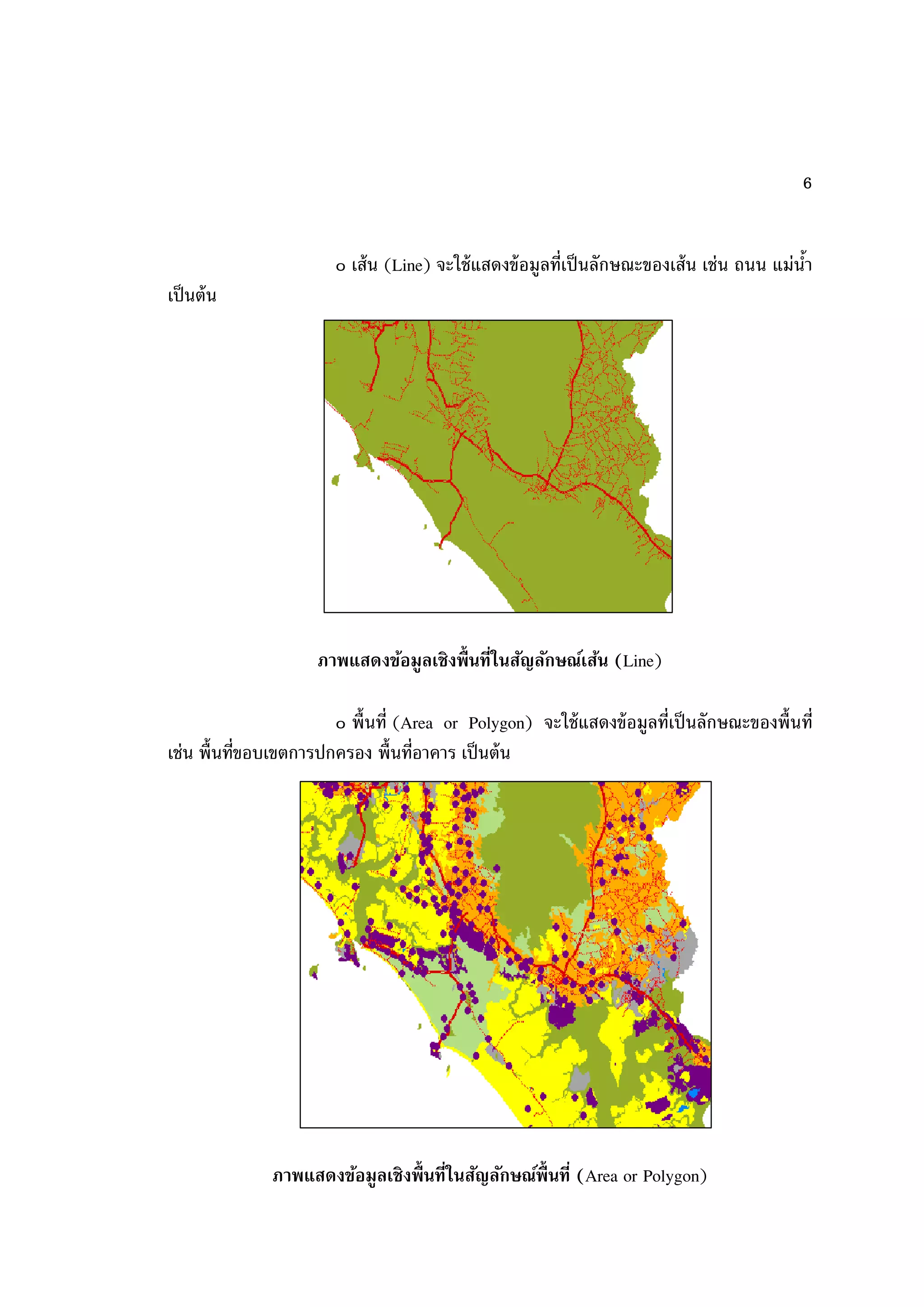
6
๐ เส้ น (Line) จะใช้ แสดงข้ อมูลที่เป็ นลักษณะของเส้ น เช่น ถนน แม่นา ้ เป็ นต้ น ภาพแสดงข้อมูลเชิงพื้ นที่ในสัญลักษณ์เส้น (Line) ๐ พื้นที่ (Area or Polygon) จะใช้ แสดงข้ อมูลที่เป็ นลักษณะของพื้นที่ เช่น พื้นที่ขอบเขตการปกครอง พื้นที่อาคาร เป็ นต้ น ภาพแสดงข้อมูลเชิงพื้ นที่ในสัญลักษณ์พนที่ (Area or Polygon) ื้
7.
7
(2) ข้ อมูลที่ไม่อยู่ในเชิงพื้ นที่ (Non-spatial data) เป็ นข้ อมูลที่เกี่ยวข้ องกับ คุณลักษณะต่างๆ ในพื้นที่น้ันๆ (Attributes) ได้ แก่ ข้ อมูลการถือครองที่ดิน ข้ อมูลปริมาณธาตุ อาหารในดิน และข้ อมูลเกี่ยวกับสภาวะเศรษฐกิจและสังคม เป็ นต้ น ระบบพิกด (Coordinate System) ั เป็ นระบบที่สร้ างขึ้นสาหรั บใช้ อ้างอิงในการกาหนดตาแหน่ง หรื อบอกตาแหน่ งพื้ นโลกจาก แผนที่มีลักษณะเป็ นตารางโครงข่ายที่เกิดจากตัดกันของเส้ น ตรงสองชุดที่ถูกกาหนดให้ วางตัวใน แนวเหนือ-ใต้ และแนวตะวันออก- ตะวันตก ตามแนวของจุดศูนย์กาเนิด (Origin) ที่กาหนดขึ้น ค่ า พิ กัดที่ใช้ อ้า งอิงในการบอกตาแหน่ งต่ า งๆ จะใช้ ค่า ของหน่ วยที่นับ ออกจากจุ ดศู นย์ ก าเนิ ด เป็ นระยะเชิงมุม (Degree) หรือเป็ นระยะทาง (Distance) ไปทางเหนือหรื อใต้ และตะวันออก หรื อตะวั นตก ตามตาแหน้ งของตาบลที่ต้องการหาค่าพิ กัดที่กาหนดตาแหน่ งต่ างๆ จะถูกเรี ยก อ้ างอิงเป็ นตัวเลขในแนวตั้งและแนวนอนตามหน่ วยวั ดระยะใช้ วัดสาหรั บระบบพิ กัดที่ใช้ อ้างอิง กาหนดตาแหน่งบนแผนที่ ที่นิยมใช้ กบแผนที่ในปัจจุบัน มีอยู่ด้วยกัน 2 ระบบ คือ ั 1) ระบบพิกดภูมิศาสตร์ (Geographic Coordinate System) ั 2) ระบบพิกดกริดแบบ UTM (Universal Transverse Mercator co-ordinate System) ั ระบบพิกดภูมิศาสตร์ (Geographic Coordinate System) ั เป็ นระบบพิ กัดที่กาหนดตาแหน่ งต่างๆบนพื้ นโลก ด้ วยวิธีการอ้ างอิงบอกตาแหน่ ง เป็ นค่า ระยะเชิ งมุ มของละติจู ด (Latitude) และ ลองติจู ด (Longtitude) ตามระยะเชิ งมุ มที่ ห่ า งจากศู น ย์ ก าเนิ ด (Origin) ของละติ จู ด และลองติ จู ด ที่ก าหนดขึ้ นส าหรั บ ศู น ย์ ก าเนิ ด ของละติจูด (Origin of Latitude) นั้นกาหนดขึ้นจากแนวระดั บ ที่ตัดผ่านศูนย์กลางของโลก และตั้งฉากกับแกนหมุน เรียกแนวระนาบศูนย์กาเนิดนั้นว่า เส้ นศูนย์สูตร (Equator) ซึ่งแบ่งโลก ออกเป็ นซีกโลกเหนือและซีกโลกใต้ ฉะนั้นค่าระยะเชิงมุมของละติจูด จะเป็ นค่าเชิงมุมที่เกิดจาก มุมที่ศูนย์กลางของโลก กับแนวระดับฐานกาเนิดมุมที่เส้ นศูนย์สูตร ที่วัดค่าของมุมออกไปทั้งซีก โลกเหนื อและซีกโลกใต้ ค่าของมุ มจะสิ้นสุดที่ข้ัวโลกเหนือและขั้วโลกใต้ มีค่าเชิ งมุ ม 90 องศา พอดี ดังนั้นการใช้ ค่าระยะเชิงมุมของละติจูดอ้ างอิงบอกตาแหน่งต่างๆ นอกจากจะกาหนดเรียก ค่าวัดเป็ น องศาลิปดา และฟิ ลิปดา แล้ วจะบอกซีกโลกเหนือหรือใต้ กากับด้ วยเสมอ
8.
8 ระบบพิกดกริดแบบ UTM (Universal
Transverse Mercator co-ordinate System) ั พิกัดกริด UTM (Universal Transverse Marcator) เป็ นระบบตารางกริดที่ใช้ ช่วยใน การก าหนดต าแหน่ ง และใช้ อ้ า งอิ ง ในการบอกต าแหน่ ง ที่ นิ ย มใช้ กั บ แผนที่ ใ นกิ จ การทหาร ของประเทศ ต่าง ๆ เกือบทั่วโลกในปั จจุ บัน เพราะเป็ นระบบตารางกริ ดที่มีขนาดรูปร่ างเท่ากัน ทุกตารางและมีวิธการกาหนดบอกค่าพิกดที่ง่าย และถูกต้ องเป็ นระบบกริดที่นาเอาเส้ นโครงแผนที่ ี ั แบบ Universal Transverse Mercator Projection ของ Gauss -Krueger มาใช้ ดัดแปลงการ ถ่ายทอดรายละเอียดของพื้ นผิวโลกให้ รู ปทรงกระบอก Mercator Projection อยู่ ในตาแหน่ ง Mercator Projection (แกนของรูปทรงกระบอกจะทับกับแนวเส้ นอิเควเตอร์ และตั้งฉากกับ แนวแกนของขั้วโลก) ประเทศไทยเราได้ นาเอาเส้ นโครงแผนที่แบบ UTM นี้มาใช้ กับการทาแผนที่ เป็ นชุด L 7017 ที่ใช้ ในปั จจุ บันแผนที่ระบบพิกัดกริด ที่ใช้ เส้ นโครงแผนที่แบบ UTM เป็ นระบบ เส้ นโครงชนิ ดหนึ่ งที่ใช้ ผิวรู ปทรงกระบอกเป็ นผิวแสดงเส้ นเมริ เดียน (หรื อเส้ นลองติจูด) และ เส้ นละติจูดของโลก โดยใช้ ทรงกระบอกตัดโลกระหว่างละติจูด 84องศาเหนือ และ 80 องศาใต้ ในลักษณะแกนรูปทรงกระบอกแล้ วทามุมกับแกนโลก 90 องศารอบโลก ความสามารถของระบบสารสนเทศภูมิศาสตร์ GIS เป็ นระบบสารสนเทศที่รวบรวมข้ อมูลเชิงพื้ นที่ (spatial data) และข้ อมูลอธิบาย ต่างๆ (attribute data) ดังนั้น จึงมีประสิทธิภาพในการวิเคราะห์ และตอบคาถามเกี่ยวกับ ความสัมพันธ์ด้านพื้นที่ได้ หลายประการ ซึ่งสามารถแบ่งออกได้ เป็ น 5 ประเภท คือ 1. Location What is at …? มีอะไรอยู่ท่ไหน ี คาถามแรกที่ GIS สามารถตอบได้ คือ มีอะไรอยู่ท่ไหน หากผู้ถามรู้ตาแหน่ งที่แน่ นอน ี เช่ น ทราบชื่ อ หมู่ บ้ า น ตาบล หรื ออาเภอแต่ ต้องการรู้ ว่ าที่ตาแหน่ งนั้ น ๆ ที่ร ายละเอียดข้ อ มู ล อะไรบ้ าง 2. Condition Where is it? สิ่งที่อยากทราบอยู่ท่ไหน ี คาถามนี้จะตรงกันข้ ามกับคาถามแรก และต้ องมีการวิเคราะห์ข้อมูล ยกตัวอย่างเช่น เรา ต้ อ งการทราบว่ า บริ เ วณใดมี ดิ น ที่ เ หมาะสมต่ อ การปลู ก พื ช อยู่ ใ กล้ แหล่ ง น้ า และไม่ อ ยู่ ในเขตป่ าอนุรักษ์ เป็ นต้ น
9.
9
3. Trends What has changed since…? ในช่วงระยะที่ผ่านมามีอะไรเปลี่ยนแปลงบ้ าง คาถามที่สามเป็ นการวิเคราะห์การเปลี่ยนแปลงในระยะช่วงเวลาใดเวลาหนึ่ง ซึ่งคาถามนี้ จะเกี่ยวข้ องกับคาถามที่หนึ่ งและคาถามที่สอง ว่ าต้ องการทราบการเปลี่ยนแปลงของอะไร และ สิ่งที่ได้ เปลี่ยนแปลงอยู่ท่ไหน มีขนาดเท่าไร เป็ นต้ น ี 4. Patterns What spatial patterns exist? ความสัมพันธ์ด้านพื้นที่เป็ นอย่างไร คาถามนี้ค่อนข้ างจะซับซ้ อนกว่าคาถามที่ 1-3 ตัวอย่างของคาถามนี้ เช่นเราอยากทราบว่า ปัจจัยอะไรเป็ นสาเหตุของการเกิดโรคท้ องร่ วงของคนที่อาศัยอยู่เชิงเขา หรือเชื้อโรคมาจากแหล่ ง ใด การตอบคาถามดังกล่าว จาเป็ นต้ องแสดงที่ต้ังแหล่งมลพิษต่างๆ ที่อยู่ใกล้ เคียง หรืออยู่เหนือ ล าธาร ซึ่ ง ลั ก ษณะการกระจาย และต าแหน่ ง ที่ ต้ั ง ของสถานที่ ดั ง กล่ า วท าให้ เราทราบถึ ง ความสัมพันธ์ของปัญหาดังกล่าว เป็ นต้ น 5. Modeling What if…? จะมีอะไรเกิดขึ้นหาก คาถามนี้จะเกี่ยวข้ องกับการคาดการณ์ว่าจะมีอะไรเกิดขึ้นหากปัจจัยอิสระ (independence factor) ซึ่งเป็ นตัวกาหนดการเปลี่ยนแปลงไป ยกตัวอย่างเช่ น จะเกิดอะไรขึ้นหากมีการตัดถนน เข้ าไปในพื้นที่ป่าสมบูรณ์ การตอบคาถามเหล่านี้บางครั้งต้ องการข้ อมูลอื่นเพิ่มเติม หรือใช้ วิธีการ ทางสถิติในการวิเคราะห์ เป็ นต้ น ข้อจากัดของระบบสารสนเทศภูมิศาสตร์ GIS เป็ นเพี ยงเครื่ องมือ (tool) ที่ช่วยให้ การวิเคราะห์ข้อมูลเชิ งพื้ นที่ สามารถทาได้ รวดเร็ว และมีประสิทธิภาพ แต่อย่างไรก็ตาม GIS ไม่สามารถทาอะไรได้ ทุกอย่าง เช่น 1. GIS ไม่สามารถปรับปรุงคุณภาพของข้ อมูลดิบ (raw data) ให้ มีความถูกต้ อง หรือ แม่ น ย าขึ้น ได้ ยกตั วอย่ า ง เช่ น ได้ น าข้ อ มู ลแผนที่ดิ น มาตราส่วน 1:100,000 ถึ งแม้ ว่า GIS สามารถพิมพ์แผนที่มาตราส่วน 1:50,000 แต่ความแม่นยาของข้ อมูลยังคงเดิม 2. GIS ไม่สามารถระบุความผิดพลาดของข้ อมูลได้ ยกตัวอย่างเช่ น เจ้ าหน้ าที่ GIS ได้ นาเข้ าข้ อมูลดินทราย แต่ได้ กาหนดข้ อมูลดังกล่าวผิดพลาดเป็ นดินร่วนปนทราย GIS ไม่สามารถ บอกได้ ว่าพื้นที่ดังกล่าวให้ รายละเอียดข้ อมูลผิด
10.
10
3. GIS ไม่สามารถเปรียบเทียบคุณภาพของข้ อมูล แต่ละชั้นข้ อมูลหรือข้ อมูลแต่ละแหล่ง ว่าข้ อมูลชุดใด หรือหน่วยงานใดผลิตข้ อมูลที่มีคุณภาพมากน้ อยกว่ากัน 4. GIS ไม่สามารถระบุได้ ว่าแบบจาลองในการวิเคราะห์ หรือเงื่อนไขต่างๆ ที่นักวิเคราะห์ GIS หรือผู้มีอานาจตัดสินใจได้ เลือ กไปนั้น ถูกต้ องหรือไม่ เพราะ GIS เป็ นเพี ยงเครื่ องมือที่ นามาใช้ ในการวิเคราะห์ข้อมูลเท่านั้น 5. GIS ไม่ทราบมาตรฐานหรือรูปแบบแผนที่ท่เป็ นสากล ยกตัวอย่างเช่น ข้ อมูล GIS ชุด ี เดียวกัน แต่ถ้านักวิเคราะห์ GIS 2 ท่าน มาจัดทาแผนที่ จะได้ แผนที่ไม่เหมือนกัน ความสวยงาม แตกต่างกัน ขึ้นอยู่กบประสบการณ์และความรู้ของผู้ผลิตแผนที่เป็ นหลัก ั 6. GIS ไม่สามารถทดแทนความรู้ ความสามารถ ของผู้เชี่ยวชาญได้ ยกตัวอย่างเช่นการ วิเคราะห์หาพื้นที่ ที่เหมาะสมต่อการใช้ ประโยชน์ท่ดิน ยังมีความจาเป็ นจะต้ องมีผ้ ูเชี่ยวชาญเรื่อง ี ดินและการวางแผนใช้ ท่ดิน เป็ นผู้กาหนดปั จจัยหรือเงื่อนไขต่างๆ นักวิเคราะห์ GIS ถึงแม้ ว่าจะมี ี ประสบการณ์ในการใช้ โปรแกรม หรื อมีข้อ มู ลเชิ งพื้ นที่และข้ อมู ลอธิบายครบถ้ วน ไม่ สามารถ ดาเนิ นการวิ เคราะห์ ดังกล่ าวให้ ได้ ผลที่เป็ นที่ถู กต้ องตามหลั กวิ ชาการได้ เพราะไม่ ได้ มีความรู้ ในเรื่องนั้นๆ จากข้ อมูลข้ างต้ นที่ได้ กล่าวมานั้น สามารถกล่าวโดยสรุปได้ ว่า ระบบสารสนเทศภูมิศาสตร์ เป็ น ข้ อมู ลที่มีความสัมพั นธ์กับการอ้ างอิงตาแหน่ งบนโลกที่เรี ยกว่ า ข้ อมู ลเชิ งพื้ นที่ (Spatial data) ฉะนั้นระบบสารสนเทศภูมิศาสตร์ จะเกี่ยวโยงกับการพั ฒนาความรู้ในแขนงสาขาต่างๆที่ เกี่ยวกับข้ อมูลเชิงพื้ นที่ท้งสิ้น ระบบสารสนเทศภูมิศาสตร์ หรือระบบ GIS เป็ นเครื่องมือที่ใช้ ใน ั การวิเคราะห์ข้อมูลเชิงพื้นที่ (Spatial data) โดยข้ อมูลลักษณะต่างๆในพื้นที่ท่ทาการศึกษา จะถูก ี น ามาจั ด ให้ อ ยู่ ใ นรู ป แบบที่มี ค วามสั ม พั น ธ์ เ ชื่ อ มโยงกั น และกั น ซึ่ ง จะขึ้ นอยู่ กับ ชนิ ด และ รายละเอียดของข้ อมูลนั้นๆ เพื่อให้ ได้ ผลลัพธ์ท่ดีท่สดตามต้ องการ ี ีุ
11.
11
เอกสารอ้างอิง - ระบบสารสนเทศภูมิศาสตร์เบื้องต้ น. [ออนไลน์]. แหล่งที่มา http://www.gis2me.com/th/?p=29 [12 มกราคม 2556] - ระบบสารสนเทศภูมิศาสตร์. [ออนไลน์]. แหล่งที่มา http://www.mahadthai.com/gis/basic.htm [12 มกราคม 2556]
Download

![11
เอกสารอ้างอิง
- ระบบสารสนเทศภูมิศาสตร์เบื้องต้ น. [ออนไลน์]. แหล่งที่มา
http://www.gis2me.com/th/?p=29 [12 มกราคม 2556]
- ระบบสารสนเทศภูมิศาสตร์. [ออนไลน์]. แหล่งที่มา
http://www.mahadthai.com/gis/basic.htm [12 มกราคม 2556]](https://image.slidesharecdn.com/gis-130114120511-phpapp02/75/Gis-11-2048.jpg)


![French School of Geographical Thoughts [Autosaved].pptx](https://cdn.slidesharecdn.com/ss_thumbnails/frenchschoolofgeographicalthoughtsautosaved-241003070312-c0f242eb-thumbnail.jpg?width=640&height=640&fit=bounds)


