SlideShare a Scribd company logo
1 of 7
Download to read offline
1
Walter H. MAYER, 10 steps to an integrated ICT concept for the management of countries. World Conference on Computers In Agriculture and
Natural Resources, University of Costa Rica, San Jose, Costa Rica, July 27th
– 30th
, 2014. http://CIGR.proceedings.org
10 steps to an integrated ICT concept for the management of countries
Dipl.Ing. Walter H. MAYER, CEO & Consultant, PROGIS® GmbH, Villach/Austria
Postgasse 6, A-9500 VILLACH, Austria
mayer@progis.com
During the last years new technologies occurred - some will help agriculture a lot.
Main tasks to make them profitable for sustainable resource management is
technology assessment based on detailed know how of a country’s situation and
needs, further technology integration concepts including an ICT infrastructure that
integrates next to Ministries or public bodies also large private entities within
agriculture and forestry. Ortho-images or networks of weather-stations are part of
the concept and must be access-able by WMS (Web Map Services) from all parties, if
wished against an access fee. Beside technology and the ICT backbone one has to
understand all stakeholders and correlations of the information flow within the agro-
(forest-, environment- natural-risk-) -processes with all tasks. Business-models have
to be set up integrating different stakeholders allowing IT-supported cooperation.
Benefits must be identified and valuated to know financial commitment(s), guidance is
recommended by local and international experts of all sectors.
KEYWORDS: ICT, GIS, FMIS, nutrient- and carbon balance, logistics, precision
farming, inclusive agriculture, stakeholder cooperation, forestry, land consolidation
A first step is the evaluation of existing public and private structures and the
information flow within/across them, available gaps and future needs of information
within these sectors. This needs acc. experience a 3-6 months assessment consultancy.
Pic 1: WinGIS with orthoimage, LPIS and farmers database as Pic 2: Farm management with DokuPlant® integrating GIS,
local application or used via WMS services for fast and time-management, expert information and applications for
countrywide coverage and carrier of many powerful applications: costs, nutrients, carbon, insurance, subsidies, thematic maps etc.
DokuPlant, ForestOffice, Logistics, PF, Land-consolidation, ...
2
Walter H. MAYER, 10 steps to an integrated ICT concept for the management of countries. World Conference on Computers In Agriculture and
Natural Resources, University of Costa Rica, San Jose, Costa Rica, July 27th
– 30th
, 2014. http://CIGR.proceedings.org
The second question will be the ICT backbone of orthoimages and weather- and
soil-sensor-station. The quality, quantity, costs and returns and the existing structures
have to be evaluated and integrated. The production of a high resolution ortho-
image (MS Bing® Maps in EU and US with 30cm resolution or other existing maps
or new flights have to be arranged) for the whole country as base for any planning and
control, not limited to a.m. sectors, to build-up an online mapping service is a must.
After this stage a third one will occur, how is the GIS element managed – not only
the top down but also the bottom up side - in a manner that the benefit reaches the
farmers and other stakeholders. When the geo-component is decided and ready – e.g.
in Europe/US we have WMS services with orthoimages, 30+cm resolution available,
in other regions of the world satellite images with 1-2(5)m - that easily can be linked
(also other images can be taken) – but - a map alone is too less. Having our spatial
engine WinGIS®, the first, very fast and powerful object oriented GIS with its own
development environment (SDK) that allows programmers easily link their db-
applications to maps, we focused where we have been coming from – out of a
consultancy office focusing on agriculture – forestry - environment and natural risk-
management. As this is one of the most complex markets within the GIS sector one
has to understand the needs of the different chain partners within this market. A map
alone is too less and does not help and cooperation of chain-partners is a must!
Preparation of LPIS (Land Parcel Information System) is the first mission for
WinGIS® - to digitize all fields and other land plots including the owners or the users
of the plots to build up a countrywide land parcel database. An Open Street Map
technology for the rural area road-network can be integrated. PROGIS®` WinGIS®
is an easy to use, easy to learn, powerful and cost efficient GIS software with
extensive geographic application possibilities.
Due to the integration of the online map data of Microsoft Bing Maps as „embedded
Module“ – also other maps can be integrated - the access to worldwide available
geographic data like satellite and aerial images, road maps and address databases is
already part of the software package. The WinGIS® import and export interfaces
support the most common GIS/CAD file formats like the ESRI™ shape files, the
AutoCAD™ DXF, MapInfo´™ MIF and also text based file formats like CSV or
GPX for data import from e.g. GPS devices. In a few steps external spatial data can be
loaded into the users WinGIS project. Imported attribute data are stored in the internal
database module of WinGIS. By using the ActiveX developer component, application
developers have the possibility to link their application very easy with WinGIS in
order to visualize, edit and administrate any data with a geographic relation.
As next the fourth step, the farm- and or forest-management has to be set in place
taking into account the needs of different users next to farmers/foresters. Some of
them will be able to run it alone, some of them will need help and support = advise. A
new possibility shows up for advisory services, independent if public or private. They
3
Walter H. MAYER, 10 steps to an integrated ICT concept for the management of countries. World Conference on Computers In Agriculture and
Natural Resources, University of Costa Rica, San Jose, Costa Rica, July 27th
– 30th
, 2014. http://CIGR.proceedings.org
will work as service providers for the stakeholder group within a region, using state of
the art technology. With such a model, country coverage can be established soon.
Beside advisory services also large farms or even food-industries can guide this
service process as everybody will benefit of it. If once a model is established,
WHERE, WHAT and WHEN an activity has to be done - an enlarged GIS application
is needed – the advisor/service provider will support this process from distributing
seeds or fertilizers till the use of machines and does business calculation, nutrient
and/or carbon balances, cost calculation, subsidy management or even business plans,
supporting insurance companies and also maps. The data come from expert models
done together with local experts.
DokuPlant® has as fundament the GIS-based local LPIS, an integrated expert
database (with all relevant agricultural data and cultivation recommendations
supported by local expert partners) and a perpetual documentation tool. With this
FMIS tools, extension officers are enabled to plan and control every field with a click,
for a farm, a region or a whole country. Following information will be generated from
every field and can be accumulated for the whole country: activity management, crop
rotation, cost calculation, nutrient balance for N, P, K, Ca, Mg, carbon balance
(models are ready to support carbon balances for complete countries to enable carbon
financing for complete countries based on measurable indicators) and if needed
energy balance, input/resource needs, harvests.
The (1) PC-GIS, (2) real-time management and the (3) expert-data base are fully
integrated within the FMIS database application. The mapping of plots/fields is
supported and a perpetual calendar enables the display of any performed activity:
what – when - where. The integrated database is filled with agro expert data,
generated in close cooperation with local agro-forest-environmental scientists/experts
and contains e.g. for Germany 2.500 agro-machine data (KTBL, costs, time, …), data
on thousands mineral-/organic-fertilizers and crops incl. varieties, 850 pesticides with
chemical contents and 400 plants with average yield and seed needs including the
prescribed complete working process for a year with all activities and resources
needed is predefined for all crops and enables planning with one click: Where (plot in
the map) do I plan what (select crop from the expert data bank). Individual farmers
can modify the expert data at any time. Similar like DokuPlant, Forest Office® has
an expert model supporting local growth tables of local species; if they are not
available, how to setup them can be trained. When the data finally are stored in
cooperation with large IT providers within an Agro-Trust-Center® - rules have to be
defined together with public and private bodies – that stakeholders incl. the farmers
are sure that their data are not misused. If we try to split private ownership of land and
ownership of the information of this land we start to destroy private ownership of land
and our democratic principles that will end in a disaster.
4
Walter H. MAYER, 10 steps to an integrated ICT concept for the management of countries. World Conference on Computers In Agriculture and
Natural Resources, University of Costa Rica, San Jose, Costa Rica, July 27th
– 30th
, 2014. http://CIGR.proceedings.org
Pic 3: Logistic with central dispatch centre, mobile GIS systems and mobile phone communication with data transfer
If in a fifth stage, logistics + mobGIS® is implemented, all mobile devices from
tractor to harvesters can be managed, guided and controlled via a WinGIS based
dispatch center. Logistic needs for group of farmers/foresters/industries will be
generated on base of accumulated data from FMIS (see above). Process- and time
optimizations, where to deliver what” or “where to pick up what and when” and how
to come to that location (with the help of the rural Open Street Map (OSM) as well as
a just in time delivery from field to industry will be realized. The systems lead to an
optimization of daily and seasonal routing, accurate information of harvest status,
GPS positioned data visualization, online two-way communication between central
and mobile terminals and order processing is supported. The software consists of a
GIS central station and any number of mobile units (“mobGIS”), integrating GIS,
communication (GPRS/UMTS) and GPS. It handles crops for food/feed or biomass
production, liquid manure deposits, forest harvesting or any other logistic task. Up to
30 % cost reductions or more could be achieved. This technology-implementation is
to communicate with all mobile devices from a central office and is the precondition
for a future Precision Farming (PF) or Precision Forestry implementation.
PF means that we can distribute on existing technology not only a contract where to
drive and what to do but also a map, a Precision Farming map as step six. The key
question will be who is managing these maps? It is a deep agricultural know how
necessary. Not the machine is intelligent, it is the map that brings the know-how to
the machines and we need information: Soil analysis with GPS, previous-, following
and in-between-crop, crop residues on the field with their chemical content, satellite
information regarding chlorophyll content etc. With this inputs agro-experts are able
to create fertilizer maps and/or pesticide maps for site specific management. If
wanted the following seventh step can be implemented: Virtual farming®, the
optimization of fields with neighbors together. Create larger and better shaped fields
and split with calculation models verified costs and revenues per m² according PF-
documentation of activities (=costs) and harvest results (=returns). It will increase
farmer´s profit.
5
Walter H. MAYER, 10 steps to an integrated ICT concept for the management of countries. World Conference on Computers In Agriculture and
Natural Resources, University of Costa Rica, San Jose, Costa Rica, July 27th
– 30th
, 2014. http://CIGR.proceedings.org
Pic 4: Precision farming integrating technology and expert know how supported by powerful tools
Groups of farmers in a region or in a country can also optimize the environment
within a step eight from changing quantity/quality of water, creating nice landscapes,
do bioenergy production or carbon buffering till influence local climates or produce
recreational areas. These services must be done with social responsibility in mind but
knowing that hard work has to be done to offer them. Similar like environment
services also natural risk reducing services as step nine can be done by groups of
farmers in a region or a country: To buffer more water upstream that less water
downstream creates no floods is an agricultural/forest service. To manage all this
more, better and accurate, just in time information is needed, the farmers can become
the transponders and the experts provide the know-how and setup projects, verify and
control the transfer and farmers get paid for their services. The technology available is
called EnvirOffice® and has also a local to be defined expert model integrated.
On top of all and as module ten, land consolidation, a job driven often by
government agencies (in Austria “Agrarbehörde”), can optimize the situation of a
region in respect to infrastructure (water, roads, landscape etc.) as well as focusing on
the optimized situation of the farmer´s fields. A further question stays: “How
informatics help integrating farmers/foresters as part of environmental caretaking,
supporting also commons?”
Pic 5: Environmental caretaking and risk management Pic 6: Land consolidation and managing of commons
are new services to be offered by farmers will help farmers AND all of us!
The nobel-prize winner Elinor Ostrom got it 2009 for business science evaluating this
question and found results beside native tribes in virgin forests (Africa, South-
America) also at Swiss farmer´s cooperatives. She worked out rules: (i) Precise
6
Walter H. MAYER, 10 steps to an integrated ICT concept for the management of countries. World Conference on Computers In Agriculture and
Natural Resources, University of Costa Rica, San Jose, Costa Rica, July 27th
– 30th
, 2014. http://CIGR.proceedings.org
defined borders, (ii) congruence between rules of acquisition & allocation, (iii) local
requirements, (iv) organizational structures for collective decisions, (v) control &
penalty, (vi) conflict solving mechanisms and (vii) a minimum organization structure.
We have such structures also in Austria in Alpine regions where farmers have their
private farm in the valleys and on the mountains cooperatives exist. It started with the
liberalization of farmers in 1849 followed by new commune laws, ground-books and
from 1883 the partitioning law of common grounds and definition of use rights for
farmers. 1883 – 1925 in the different Austrian countries the regional legislation was
setup and a public organization “Agrarbehörde” was established as the public
structure to incorporate and control the cooperatives. They have technical and legal
departments and in Carinthia (southern region in Austria) 40 people working for 1715
cooperatives with 138.083 ha (avg. 80 ha), 1885: 3013 coops in 230 communes, 1913:
2065 cooperatives with 136.175 ha. The single coop is managed by a board
(chairman, treasurer, cash controller) and a general assembly.
The future will show virtual cooperatives, based on local sub-targets with inclusive
regional, EC- or even worldwide targets and co-defined and supported also by local
communes, managed under a public entity with local farmers engaged and working
also for regional defined and needed environmental- or risk-management targets that
are project oriented setup and developed and managed by this public entity in close
cooperation with the communes and the general population. When a project/task is
finished, involved farmers get paid acc. services they as a person and/or their land
delivers to the general public regarding these commons. In the past - we had few
people on the Earth and many commons - we did not need to manage them. In future
with 10 bio people and increasing pressure on commons we must manage them.
Farmers/foresters have to fulfill these works based on a social responsibility as private
or cooperative owners. Information is the key to manage them better as we can plan,
work, control and pay according local targets supported by the communes
representing the population and developed together with experts! As chairman of a
cooperative I know that the willingness to pay only shows up if the general people
understand that not managed commons will disappear what will harm everybody!
The beneficiaries: In general – much of the information prepared by the agricultural
ICT backbone can be used by several stakeholders and will be a benefit for several
businesses. It means chain-partners will be ready to pay to get access to the
information! The model in detail has to be worked out together with local structures
and representatives from different stakeholders! A public-private used ICT
infrastructure, consisting of new ortho-images for the country covering GIS and IT
solutions for rural area management in connection with land-management and
extension-services, agriculture management and logistics can be used by different
governmental organizations and can also be used by private structures and is:
- Supporting the Minister of Agriculture for his needs to organize subsidies,
- Supporting the Ministry for landscape changes, cadaster, ground tax
- Supporting consultants in their advisory work
7
Walter H. MAYER, 10 steps to an integrated ICT concept for the management of countries. World Conference on Computers In Agriculture and
Natural Resources, University of Costa Rica, San Jose, Costa Rica, July 27th
– 30th
, 2014. http://CIGR.proceedings.org
- Supporting food chain partners: traceability, documentation
- Supporting logistic services to do right actions at the right field to find the
right roads, be there at the right time and deliver goods to the food industry
“just in time” is a support to all suppliers and buyers of farm goods
- Supporting the agro control organization for subsidies
- Supporting bankers - business-plans enabling financing farmers on ROI
- Supporting insurance companies to do the right policies for the right crops
- Supporting the ecology expert or also the natural-risk-manager for the
appraisal of the risks related with field or ecological coherences
- Supporting human medicine experts to judge the influence of the activity
of the farmers (food and environment) towards the whole population
- Supporting farmers to give them tools for bettering economic calculations,
better access to markets, gets new service business in environment etc.
To all mentioned groups the ICT-backbone can produce valuable services. For these
services lots of ROI-money could be acquired but stays a political decision. (ROI
calculations for single sectors can be done on request). Naturally also a model is
imaginable, where public (MOA) and private (banks, insurance, investors) share the
investment and setup a Joint Venture.
Stakeholders of all the processes can be small/large farmers, advisors, Ministries,
public organizations, banks, insurance, telecom, food/feed industry, cooperatives,
certification companies, controllers, environment- and natural-risk-management etc..
Everything we talked is developed, must be fine-tuned with integration of local
experts of all sectors and can be implemented everywhere within 3-5 years.
Mankind produces worldwide crops (1.5 bio ha), animals (3,5 bio ha) and forests (<5
bio ha) on ca. 10 bio hectares with an avg. output of – guessed, a worldwide avg.
number is not available – € 500,--/ha. This total value of 5 Trio € must be managed
sustainably and optimized with economic and ecologic targets, having in mind the
carrying capacity of the land, the needs of the population and in parallel increase the
value of the – better managed - land. A 10% increase/optimization will be € 50
Bio/year or 50 € per ha! A better managed land will have a better price per ha – we
increase farmers assets but also the assets of whole countries. A target we should
work for and decide fast to manage our globe better – all together! ©DI Mayer - 2014

More Related Content

Similar to 10-Step ICT Concept Integrates Agriculture Management

2017 Basics of GIS
2017 Basics of GIS2017 Basics of GIS
2017 Basics of GISAtiqa khan
 
Smartrural Digital resilience for rural worlds
Smartrural Digital resilience for rural worldsSmartrural Digital resilience for rural worlds
Smartrural Digital resilience for rural worldsAlfonso Crisci
 
GI2010 symposium-ws3.2-intro mayer (abstract)
GI2010 symposium-ws3.2-intro mayer (abstract)GI2010 symposium-ws3.2-intro mayer (abstract)
GI2010 symposium-ws3.2-intro mayer (abstract)IGN Vorstand
 
ihub A creative platform for innovations that change the lives of farmers
ihub A creative platform for innovations that change the lives of farmersihub A creative platform for innovations that change the lives of farmers
ihub A creative platform for innovations that change the lives of farmersICRISAT
 
Spatial Data Infrastructure (SDI) Is An Information...
Spatial Data Infrastructure (SDI) Is An Information...Spatial Data Infrastructure (SDI) Is An Information...
Spatial Data Infrastructure (SDI) Is An Information...Stacey Wilson
 
SC7 Workshop 3: Space-based applications and Big Data
SC7 Workshop 3: Space-based applications and Big DataSC7 Workshop 3: Space-based applications and Big Data
SC7 Workshop 3: Space-based applications and Big DataBigData_Europe
 
Programme on Climate Information for Resilient Development in Africa
Programme on Climate Information for Resilient Development in AfricaProgramme on Climate Information for Resilient Development in Africa
Programme on Climate Information for Resilient Development in AfricaUNDP Climate
 
Case study: Programme on Climate Information for Resilient Development in Afr...
Case study: Programme on Climate Information for Resilient Development in Afr...Case study: Programme on Climate Information for Resilient Development in Afr...
Case study: Programme on Climate Information for Resilient Development in Afr...ExternalEvents
 
Geographical Information System and Karnataka Forest cover digitization
Geographical Information System and Karnataka Forest cover digitizationGeographical Information System and Karnataka Forest cover digitization
Geographical Information System and Karnataka Forest cover digitizationKamlesh Kumar
 
applications of cloud computing for agricultural sector
applications of cloud computing for agricultural sectorapplications of cloud computing for agricultural sector
applications of cloud computing for agricultural sectorSwathi Rampur
 
GIS for geophysics.pptx
GIS for geophysics.pptxGIS for geophysics.pptx
GIS for geophysics.pptxThomasHundasa1
 
Module 10 - Section 6 ICTs for climate change adaptation 20110904
Module 10 - Section 6 ICTs for climate change adaptation 20110904Module 10 - Section 6 ICTs for climate change adaptation 20110904
Module 10 - Section 6 ICTs for climate change adaptation 20110904Richard Labelle
 
Krijn Poppe nifa data summit Chicago 2016
Krijn Poppe nifa data summit Chicago 2016Krijn Poppe nifa data summit Chicago 2016
Krijn Poppe nifa data summit Chicago 2016Krijn Poppe
 
ICRISAT Global Planning Meeting 2019: Digital Agriculture and Youth by Ram Dh...
ICRISAT Global Planning Meeting 2019: Digital Agriculture and Youth by Ram Dh...ICRISAT Global Planning Meeting 2019: Digital Agriculture and Youth by Ram Dh...
ICRISAT Global Planning Meeting 2019: Digital Agriculture and Youth by Ram Dh...ICRISAT
 
FOODIE newsletter issue #6
FOODIE newsletter issue #6FOODIE newsletter issue #6
FOODIE newsletter issue #6FOODIE_Project
 
ICT and Disaster Management
ICT and Disaster ManagementICT and Disaster Management
ICT and Disaster ManagementDavid Merrick II
 
GI2014_abstract+summary_AUTHORNAME.doc
GI2014_abstract+summary_AUTHORNAME.docGI2014_abstract+summary_AUTHORNAME.doc
GI2014_abstract+summary_AUTHORNAME.docIGN Vorstand
 

Similar to 10-Step ICT Concept Integrates Agriculture Management (20)

2017 Basics of GIS
2017 Basics of GIS2017 Basics of GIS
2017 Basics of GIS
 
Smartrural Digital resilience for rural worlds
Smartrural Digital resilience for rural worldsSmartrural Digital resilience for rural worlds
Smartrural Digital resilience for rural worlds
 
GI2010 symposium-ws3.2-intro mayer (abstract)
GI2010 symposium-ws3.2-intro mayer (abstract)GI2010 symposium-ws3.2-intro mayer (abstract)
GI2010 symposium-ws3.2-intro mayer (abstract)
 
ihub A creative platform for innovations that change the lives of farmers
ihub A creative platform for innovations that change the lives of farmersihub A creative platform for innovations that change the lives of farmers
ihub A creative platform for innovations that change the lives of farmers
 
Spatial Data Infrastructure (SDI) Is An Information...
Spatial Data Infrastructure (SDI) Is An Information...Spatial Data Infrastructure (SDI) Is An Information...
Spatial Data Infrastructure (SDI) Is An Information...
 
FINAL 31,12,10
FINAL 31,12,10FINAL 31,12,10
FINAL 31,12,10
 
SC7 Workshop 3: Space-based applications and Big Data
SC7 Workshop 3: Space-based applications and Big DataSC7 Workshop 3: Space-based applications and Big Data
SC7 Workshop 3: Space-based applications and Big Data
 
Programme on Climate Information for Resilient Development in Africa
Programme on Climate Information for Resilient Development in AfricaProgramme on Climate Information for Resilient Development in Africa
Programme on Climate Information for Resilient Development in Africa
 
Case study: Programme on Climate Information for Resilient Development in Afr...
Case study: Programme on Climate Information for Resilient Development in Afr...Case study: Programme on Climate Information for Resilient Development in Afr...
Case study: Programme on Climate Information for Resilient Development in Afr...
 
Smart_City
Smart_CitySmart_City
Smart_City
 
Geographical Information System and Karnataka Forest cover digitization
Geographical Information System and Karnataka Forest cover digitizationGeographical Information System and Karnataka Forest cover digitization
Geographical Information System and Karnataka Forest cover digitization
 
applications of cloud computing for agricultural sector
applications of cloud computing for agricultural sectorapplications of cloud computing for agricultural sector
applications of cloud computing for agricultural sector
 
GIS for geophysics.pptx
GIS for geophysics.pptxGIS for geophysics.pptx
GIS for geophysics.pptx
 
Module 10 - Section 6 ICTs for climate change adaptation 20110904
Module 10 - Section 6 ICTs for climate change adaptation 20110904Module 10 - Section 6 ICTs for climate change adaptation 20110904
Module 10 - Section 6 ICTs for climate change adaptation 20110904
 
Krijn Poppe nifa data summit Chicago 2016
Krijn Poppe nifa data summit Chicago 2016Krijn Poppe nifa data summit Chicago 2016
Krijn Poppe nifa data summit Chicago 2016
 
ICRISAT Global Planning Meeting 2019: Digital Agriculture and Youth by Ram Dh...
ICRISAT Global Planning Meeting 2019: Digital Agriculture and Youth by Ram Dh...ICRISAT Global Planning Meeting 2019: Digital Agriculture and Youth by Ram Dh...
ICRISAT Global Planning Meeting 2019: Digital Agriculture and Youth by Ram Dh...
 
FOODIE newsletter issue #6
FOODIE newsletter issue #6FOODIE newsletter issue #6
FOODIE newsletter issue #6
 
ICT and Disaster Management
ICT and Disaster ManagementICT and Disaster Management
ICT and Disaster Management
 
GIS Arena
GIS ArenaGIS Arena
GIS Arena
 
GI2014_abstract+summary_AUTHORNAME.doc
GI2014_abstract+summary_AUTHORNAME.docGI2014_abstract+summary_AUTHORNAME.doc
GI2014_abstract+summary_AUTHORNAME.doc
 

10-Step ICT Concept Integrates Agriculture Management

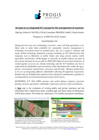
  • 1. 1 Walter H. MAYER, 10 steps to an integrated ICT concept for the management of countries. World Conference on Computers In Agriculture and Natural Resources, University of Costa Rica, San Jose, Costa Rica, July 27th – 30th , 2014. http://CIGR.proceedings.org 10 steps to an integrated ICT concept for the management of countries Dipl.Ing. Walter H. MAYER, CEO & Consultant, PROGIS® GmbH, Villach/Austria Postgasse 6, A-9500 VILLACH, Austria mayer@progis.com During the last years new technologies occurred - some will help agriculture a lot. Main tasks to make them profitable for sustainable resource management is technology assessment based on detailed know how of a country’s situation and needs, further technology integration concepts including an ICT infrastructure that integrates next to Ministries or public bodies also large private entities within agriculture and forestry. Ortho-images or networks of weather-stations are part of the concept and must be access-able by WMS (Web Map Services) from all parties, if wished against an access fee. Beside technology and the ICT backbone one has to understand all stakeholders and correlations of the information flow within the agro- (forest-, environment- natural-risk-) -processes with all tasks. Business-models have to be set up integrating different stakeholders allowing IT-supported cooperation. Benefits must be identified and valuated to know financial commitment(s), guidance is recommended by local and international experts of all sectors. KEYWORDS: ICT, GIS, FMIS, nutrient- and carbon balance, logistics, precision farming, inclusive agriculture, stakeholder cooperation, forestry, land consolidation A first step is the evaluation of existing public and private structures and the information flow within/across them, available gaps and future needs of information within these sectors. This needs acc. experience a 3-6 months assessment consultancy. Pic 1: WinGIS with orthoimage, LPIS and farmers database as Pic 2: Farm management with DokuPlant® integrating GIS, local application or used via WMS services for fast and time-management, expert information and applications for countrywide coverage and carrier of many powerful applications: costs, nutrients, carbon, insurance, subsidies, thematic maps etc. DokuPlant, ForestOffice, Logistics, PF, Land-consolidation, ...
  • 2. 2 Walter H. MAYER, 10 steps to an integrated ICT concept for the management of countries. World Conference on Computers In Agriculture and Natural Resources, University of Costa Rica, San Jose, Costa Rica, July 27th – 30th , 2014. http://CIGR.proceedings.org The second question will be the ICT backbone of orthoimages and weather- and soil-sensor-station. The quality, quantity, costs and returns and the existing structures have to be evaluated and integrated. The production of a high resolution ortho- image (MS Bing® Maps in EU and US with 30cm resolution or other existing maps or new flights have to be arranged) for the whole country as base for any planning and control, not limited to a.m. sectors, to build-up an online mapping service is a must. After this stage a third one will occur, how is the GIS element managed – not only the top down but also the bottom up side - in a manner that the benefit reaches the farmers and other stakeholders. When the geo-component is decided and ready – e.g. in Europe/US we have WMS services with orthoimages, 30+cm resolution available, in other regions of the world satellite images with 1-2(5)m - that easily can be linked (also other images can be taken) – but - a map alone is too less. Having our spatial engine WinGIS®, the first, very fast and powerful object oriented GIS with its own development environment (SDK) that allows programmers easily link their db- applications to maps, we focused where we have been coming from – out of a consultancy office focusing on agriculture – forestry - environment and natural risk- management. As this is one of the most complex markets within the GIS sector one has to understand the needs of the different chain partners within this market. A map alone is too less and does not help and cooperation of chain-partners is a must! Preparation of LPIS (Land Parcel Information System) is the first mission for WinGIS® - to digitize all fields and other land plots including the owners or the users of the plots to build up a countrywide land parcel database. An Open Street Map technology for the rural area road-network can be integrated. PROGIS®` WinGIS® is an easy to use, easy to learn, powerful and cost efficient GIS software with extensive geographic application possibilities. Due to the integration of the online map data of Microsoft Bing Maps as „embedded Module“ – also other maps can be integrated - the access to worldwide available geographic data like satellite and aerial images, road maps and address databases is already part of the software package. The WinGIS® import and export interfaces support the most common GIS/CAD file formats like the ESRI™ shape files, the AutoCAD™ DXF, MapInfo´™ MIF and also text based file formats like CSV or GPX for data import from e.g. GPS devices. In a few steps external spatial data can be loaded into the users WinGIS project. Imported attribute data are stored in the internal database module of WinGIS. By using the ActiveX developer component, application developers have the possibility to link their application very easy with WinGIS in order to visualize, edit and administrate any data with a geographic relation. As next the fourth step, the farm- and or forest-management has to be set in place taking into account the needs of different users next to farmers/foresters. Some of them will be able to run it alone, some of them will need help and support = advise. A new possibility shows up for advisory services, independent if public or private. They
  • 3. 3 Walter H. MAYER, 10 steps to an integrated ICT concept for the management of countries. World Conference on Computers In Agriculture and Natural Resources, University of Costa Rica, San Jose, Costa Rica, July 27th – 30th , 2014. http://CIGR.proceedings.org will work as service providers for the stakeholder group within a region, using state of the art technology. With such a model, country coverage can be established soon. Beside advisory services also large farms or even food-industries can guide this service process as everybody will benefit of it. If once a model is established, WHERE, WHAT and WHEN an activity has to be done - an enlarged GIS application is needed – the advisor/service provider will support this process from distributing seeds or fertilizers till the use of machines and does business calculation, nutrient and/or carbon balances, cost calculation, subsidy management or even business plans, supporting insurance companies and also maps. The data come from expert models done together with local experts. DokuPlant® has as fundament the GIS-based local LPIS, an integrated expert database (with all relevant agricultural data and cultivation recommendations supported by local expert partners) and a perpetual documentation tool. With this FMIS tools, extension officers are enabled to plan and control every field with a click, for a farm, a region or a whole country. Following information will be generated from every field and can be accumulated for the whole country: activity management, crop rotation, cost calculation, nutrient balance for N, P, K, Ca, Mg, carbon balance (models are ready to support carbon balances for complete countries to enable carbon financing for complete countries based on measurable indicators) and if needed energy balance, input/resource needs, harvests. The (1) PC-GIS, (2) real-time management and the (3) expert-data base are fully integrated within the FMIS database application. The mapping of plots/fields is supported and a perpetual calendar enables the display of any performed activity: what – when - where. The integrated database is filled with agro expert data, generated in close cooperation with local agro-forest-environmental scientists/experts and contains e.g. for Germany 2.500 agro-machine data (KTBL, costs, time, …), data on thousands mineral-/organic-fertilizers and crops incl. varieties, 850 pesticides with chemical contents and 400 plants with average yield and seed needs including the prescribed complete working process for a year with all activities and resources needed is predefined for all crops and enables planning with one click: Where (plot in the map) do I plan what (select crop from the expert data bank). Individual farmers can modify the expert data at any time. Similar like DokuPlant, Forest Office® has an expert model supporting local growth tables of local species; if they are not available, how to setup them can be trained. When the data finally are stored in cooperation with large IT providers within an Agro-Trust-Center® - rules have to be defined together with public and private bodies – that stakeholders incl. the farmers are sure that their data are not misused. If we try to split private ownership of land and ownership of the information of this land we start to destroy private ownership of land and our democratic principles that will end in a disaster.
  • 4. 4 Walter H. MAYER, 10 steps to an integrated ICT concept for the management of countries. World Conference on Computers In Agriculture and Natural Resources, University of Costa Rica, San Jose, Costa Rica, July 27th – 30th , 2014. http://CIGR.proceedings.org Pic 3: Logistic with central dispatch centre, mobile GIS systems and mobile phone communication with data transfer If in a fifth stage, logistics + mobGIS® is implemented, all mobile devices from tractor to harvesters can be managed, guided and controlled via a WinGIS based dispatch center. Logistic needs for group of farmers/foresters/industries will be generated on base of accumulated data from FMIS (see above). Process- and time optimizations, where to deliver what” or “where to pick up what and when” and how to come to that location (with the help of the rural Open Street Map (OSM) as well as a just in time delivery from field to industry will be realized. The systems lead to an optimization of daily and seasonal routing, accurate information of harvest status, GPS positioned data visualization, online two-way communication between central and mobile terminals and order processing is supported. The software consists of a GIS central station and any number of mobile units (“mobGIS”), integrating GIS, communication (GPRS/UMTS) and GPS. It handles crops for food/feed or biomass production, liquid manure deposits, forest harvesting or any other logistic task. Up to 30 % cost reductions or more could be achieved. This technology-implementation is to communicate with all mobile devices from a central office and is the precondition for a future Precision Farming (PF) or Precision Forestry implementation. PF means that we can distribute on existing technology not only a contract where to drive and what to do but also a map, a Precision Farming map as step six. The key question will be who is managing these maps? It is a deep agricultural know how necessary. Not the machine is intelligent, it is the map that brings the know-how to the machines and we need information: Soil analysis with GPS, previous-, following and in-between-crop, crop residues on the field with their chemical content, satellite information regarding chlorophyll content etc. With this inputs agro-experts are able to create fertilizer maps and/or pesticide maps for site specific management. If wanted the following seventh step can be implemented: Virtual farming®, the optimization of fields with neighbors together. Create larger and better shaped fields and split with calculation models verified costs and revenues per m² according PF- documentation of activities (=costs) and harvest results (=returns). It will increase farmer´s profit.
  • 5. 5 Walter H. MAYER, 10 steps to an integrated ICT concept for the management of countries. World Conference on Computers In Agriculture and Natural Resources, University of Costa Rica, San Jose, Costa Rica, July 27th – 30th , 2014. http://CIGR.proceedings.org Pic 4: Precision farming integrating technology and expert know how supported by powerful tools Groups of farmers in a region or in a country can also optimize the environment within a step eight from changing quantity/quality of water, creating nice landscapes, do bioenergy production or carbon buffering till influence local climates or produce recreational areas. These services must be done with social responsibility in mind but knowing that hard work has to be done to offer them. Similar like environment services also natural risk reducing services as step nine can be done by groups of farmers in a region or a country: To buffer more water upstream that less water downstream creates no floods is an agricultural/forest service. To manage all this more, better and accurate, just in time information is needed, the farmers can become the transponders and the experts provide the know-how and setup projects, verify and control the transfer and farmers get paid for their services. The technology available is called EnvirOffice® and has also a local to be defined expert model integrated. On top of all and as module ten, land consolidation, a job driven often by government agencies (in Austria “Agrarbehörde”), can optimize the situation of a region in respect to infrastructure (water, roads, landscape etc.) as well as focusing on the optimized situation of the farmer´s fields. A further question stays: “How informatics help integrating farmers/foresters as part of environmental caretaking, supporting also commons?” Pic 5: Environmental caretaking and risk management Pic 6: Land consolidation and managing of commons are new services to be offered by farmers will help farmers AND all of us! The nobel-prize winner Elinor Ostrom got it 2009 for business science evaluating this question and found results beside native tribes in virgin forests (Africa, South- America) also at Swiss farmer´s cooperatives. She worked out rules: (i) Precise
  • 6. 6 Walter H. MAYER, 10 steps to an integrated ICT concept for the management of countries. World Conference on Computers In Agriculture and Natural Resources, University of Costa Rica, San Jose, Costa Rica, July 27th – 30th , 2014. http://CIGR.proceedings.org defined borders, (ii) congruence between rules of acquisition & allocation, (iii) local requirements, (iv) organizational structures for collective decisions, (v) control & penalty, (vi) conflict solving mechanisms and (vii) a minimum organization structure. We have such structures also in Austria in Alpine regions where farmers have their private farm in the valleys and on the mountains cooperatives exist. It started with the liberalization of farmers in 1849 followed by new commune laws, ground-books and from 1883 the partitioning law of common grounds and definition of use rights for farmers. 1883 – 1925 in the different Austrian countries the regional legislation was setup and a public organization “Agrarbehörde” was established as the public structure to incorporate and control the cooperatives. They have technical and legal departments and in Carinthia (southern region in Austria) 40 people working for 1715 cooperatives with 138.083 ha (avg. 80 ha), 1885: 3013 coops in 230 communes, 1913: 2065 cooperatives with 136.175 ha. The single coop is managed by a board (chairman, treasurer, cash controller) and a general assembly. The future will show virtual cooperatives, based on local sub-targets with inclusive regional, EC- or even worldwide targets and co-defined and supported also by local communes, managed under a public entity with local farmers engaged and working also for regional defined and needed environmental- or risk-management targets that are project oriented setup and developed and managed by this public entity in close cooperation with the communes and the general population. When a project/task is finished, involved farmers get paid acc. services they as a person and/or their land delivers to the general public regarding these commons. In the past - we had few people on the Earth and many commons - we did not need to manage them. In future with 10 bio people and increasing pressure on commons we must manage them. Farmers/foresters have to fulfill these works based on a social responsibility as private or cooperative owners. Information is the key to manage them better as we can plan, work, control and pay according local targets supported by the communes representing the population and developed together with experts! As chairman of a cooperative I know that the willingness to pay only shows up if the general people understand that not managed commons will disappear what will harm everybody! The beneficiaries: In general – much of the information prepared by the agricultural ICT backbone can be used by several stakeholders and will be a benefit for several businesses. It means chain-partners will be ready to pay to get access to the information! The model in detail has to be worked out together with local structures and representatives from different stakeholders! A public-private used ICT infrastructure, consisting of new ortho-images for the country covering GIS and IT solutions for rural area management in connection with land-management and extension-services, agriculture management and logistics can be used by different governmental organizations and can also be used by private structures and is: - Supporting the Minister of Agriculture for his needs to organize subsidies, - Supporting the Ministry for landscape changes, cadaster, ground tax - Supporting consultants in their advisory work
  • 7. 7 Walter H. MAYER, 10 steps to an integrated ICT concept for the management of countries. World Conference on Computers In Agriculture and Natural Resources, University of Costa Rica, San Jose, Costa Rica, July 27th – 30th , 2014. http://CIGR.proceedings.org - Supporting food chain partners: traceability, documentation - Supporting logistic services to do right actions at the right field to find the right roads, be there at the right time and deliver goods to the food industry “just in time” is a support to all suppliers and buyers of farm goods - Supporting the agro control organization for subsidies - Supporting bankers - business-plans enabling financing farmers on ROI - Supporting insurance companies to do the right policies for the right crops - Supporting the ecology expert or also the natural-risk-manager for the appraisal of the risks related with field or ecological coherences - Supporting human medicine experts to judge the influence of the activity of the farmers (food and environment) towards the whole population - Supporting farmers to give them tools for bettering economic calculations, better access to markets, gets new service business in environment etc. To all mentioned groups the ICT-backbone can produce valuable services. For these services lots of ROI-money could be acquired but stays a political decision. (ROI calculations for single sectors can be done on request). Naturally also a model is imaginable, where public (MOA) and private (banks, insurance, investors) share the investment and setup a Joint Venture. Stakeholders of all the processes can be small/large farmers, advisors, Ministries, public organizations, banks, insurance, telecom, food/feed industry, cooperatives, certification companies, controllers, environment- and natural-risk-management etc.. Everything we talked is developed, must be fine-tuned with integration of local experts of all sectors and can be implemented everywhere within 3-5 years. Mankind produces worldwide crops (1.5 bio ha), animals (3,5 bio ha) and forests (<5 bio ha) on ca. 10 bio hectares with an avg. output of – guessed, a worldwide avg. number is not available – € 500,--/ha. This total value of 5 Trio € must be managed sustainably and optimized with economic and ecologic targets, having in mind the carrying capacity of the land, the needs of the population and in parallel increase the value of the – better managed - land. A 10% increase/optimization will be € 50 Bio/year or 50 € per ha! A better managed land will have a better price per ha – we increase farmers assets but also the assets of whole countries. A target we should work for and decide fast to manage our globe better – all together! ©DI Mayer - 2014