This document summarizes a field trip through Guatemala that observed various geological formations and sites. The trip made 14 stops to examine:
1) Obsidian deposits near Guatemala City
2) Rhyolitic ignimbrites and volcanic formations in the highlands
3) Eocene molasses deposits along the Motagua Fault
4) The North Motagua ophiolitic belt near San Agustin
5) A paleontological museum along the way to Rio Dulce
6) The Quirigua Maya ruins
7) The Juan de Paz-Los Mariscos ophiolitic belt and laterite deposits
8) Additional ophiolite
NICKEL LATERITE DEPOSITS
Geology and Lineament Analysis of the Baja Verapaz Ophiolitic Complex
Summary
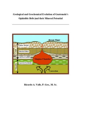
The Baja Verapaz Ophiolitic Complex encompasses an ophiolitic complex protruding metamorphic rocks from the Chuacús Series in Central Guatemala. The targeted mineralization is represented by two types of Nickel-Cobalt laterite deposits, an in situ type and an alluvial-deluvial type. A typical laterite profile consists of a Limonitic Horizon which is separated from the Saprolite Horizon by a transition zone named the Mottled Zone. The Saprolite Horizon lays over the Saprock that transitions into the Bedrock, usually represented by serpentinized olivine-rich Lherzolites or Dunites. The usual thickness of these deposits averages 33 meters, but there are known intersections of more than 90 meters in the area.
Nickel content varies from 0.4% in the Limonite Horizon to over 1.5% at the bottom of the Saprolite Horizon. Higher values are sometime found associated to the presence of Garnierite.
Cobalt values vary from 0.08 to 0.2%. There is also the presence of traces of Au and PGM, usually associated to the Mottled Zone.
The lineament analysis completed over an area of 1,541.22 km2 encompassing the whole Baja Verapaz ophiolitic complex, was aimed to identify other potential zones of laterite development in this area. The lineament analysis was completed using a combination of topographic maps in electronic format, aero photos and a D.E.M. of the region and included an aeromagnetic survey of the area. The study also included image interpretation of satellite images and 3D strain and stress analysis.
The study indicated the existence of new potential targets and clarified the relationship between the known deposits.
A FIELD TRIP THROUGH CENTRAL GUATEMALA
The NW corner of the Caribbean Plate is complicated by the presence of a continental type block, the Chortis Block, within a mostly oceanic plate and a combination of a slip-strike boundary to the north running from the Belize-Guatemala border with a subduction zone to the west where the Cocos Plate is subducted beneath the Caribbean Plate, and an extinguished subduction zones to the north and south, were the Caribbean Plate was temporarily subducted beneath the Maya and Chortis Block.
The Author believes that the migration of the Chortis block in an S-SW and then N direction was one of the mechanisms responsible for the changes observed among the ophiolitic complexes in Guatemala. The Author introduces the idea of the pre-existence of a trench associated with the Motagua-Jalomáx slip-strike fault system near the north border of Honduras, currently filled up and destroyed by the northward migration of the Chortis Block. Also, he introduces the idea of an orogenic event - The Chuacús Orogeny - probably the same age as the Laramide Orogeny in North America. The Author postulate that the Chuacús Orogeny pushed younger ophiolites complexes in Guatemala to the surface and is responsible for the metamorphic basin of Central Guatemala - The Chuacús Series. The obduction of the oldest ophiolites on the western end of the belts may have being caused by the passing by of the Jamaica block on its way to its present position south of Cuba.
NICKEL LATERITE DEPOSITS
Geology and Lineament Analysis of the Baja Verapaz Ophiolitic Complex
Summary
The Baja Verapaz Ophiolitic Complex encompasses an ophiolitic complex protruding metamorphic rocks from the Chuacús Series in Central Guatemala. The targeted mineralization is represented by two types of Nickel-Cobalt laterite deposits, an in situ type and an alluvial-deluvial type. A typical laterite profile consists of a Limonitic Horizon which is separated from the Saprolite Horizon by a transition zone named the Mottled Zone. The Saprolite Horizon lays over the Saprock that transitions into the Bedrock, usually represented by serpentinized olivine-rich Lherzolites or Dunites. The usual thickness of these deposits averages 33 meters, but there are known intersections of more than 90 meters in the area.
Nickel content varies from 0.4% in the Limonite Horizon to over 1.5% at the bottom of the Saprolite Horizon. Higher values are sometime found associated to the presence of Garnierite.
Cobalt values vary from 0.08 to 0.2%. There is also the presence of traces of Au and PGM, usually associated to the Mottled Zone.
The lineament analysis completed over an area of 1,541.22 km2 encompassing the whole Baja Verapaz ophiolitic complex, was aimed to identify other potential zones of laterite development in this area. The lineament analysis was completed using a combination of topographic maps in electronic format, aero photos and a D.E.M. of the region and included an aeromagnetic survey of the area. The study also included image interpretation of satellite images and 3D strain and stress analysis.
The study indicated the existence of new potential targets and clarified the relationship between the known deposits.
A FIELD TRIP THROUGH CENTRAL GUATEMALA
The NW corner of the Caribbean Plate is complicated by the presence of a continental type block, the Chortis Block, within a mostly oceanic plate and a combination of a slip-strike boundary to the north running from the Belize-Guatemala border with a subduction zone to the west where the Cocos Plate is subducted beneath the Caribbean Plate, and an extinguished subduction zones to the north and south, were the Caribbean Plate was temporarily subducted beneath the Maya and Chortis Block.
The Author believes that the migration of the Chortis block in an S-SW and then N direction was one of the mechanisms responsible for the changes observed among the ophiolitic complexes in Guatemala. The Author introduces the idea of the pre-existence of a trench associated with the Motagua-Jalomáx slip-strike fault system near the north border of Honduras, currently filled up and destroyed by the northward migration of the Chortis Block. Also, he introduces the idea of an orogenic event - The Chuacús Orogeny - probably the same age as the Laramide Orogeny in North America. The Author postulate that the Chuacús Orogeny pushed younger ophiolites complexes in Guatemala to the surface and is responsible for the metamorphic basin of Central Guatemala - The Chuacús Series. The obduction of the oldest ophiolites on the western end of the belts may have being caused by the passing by of the Jamaica block on its way to its present position south of Cuba.
Part 1 of 10
Introduction to the Ophiolitic Belts
INTRODUCTION
The aim of this book is to provide an overview of the ophiolitic processes associated with the Motagua Suture Zone in Guatemala and to show their mineral potential. It includes the final version of the Field Trip to Guatemala designed by the Author.
In preparing this book I have compiled information from different sources, including several internet sources, combined with my personal experiences in the mapping of the area and help and cooperation of the geologists from the Guatemalan Ministry of Energy and Mines.
The Caribbean Plate (Fig. 1) is the result of the Mesozoic-Present interaction of the Nazca, Cocos, North, and South American plates. The margins of these plates are represented by large deformed belts which resulted from several compressional episodes that started in the Cretaceous and were followed by tensional and strike-slip tectonics.
The present-day north-western margin of the Caribbean Plate crops out in Guatemala along the Motagua Suture Zone (MSZ). This zone links the Meso-American trench with the Cayman Islands extensional system as shown in Fig. 2.
The MSZ represents a sinistral shear-zone between the Maya Continental Block (MCB) to the north and the Chortis Continental Block (ChCB) to the south. The MSZ includes the Motagua Fault Systems of Polochic, Motagua, Cabañas, and Jocotán. All these are E-W and ENE-WSW strike-slip faults. Some of them are still seismically active. The MSZ also includes E-W uplift structures (Sierra de Chuacús, Sierra de Las Minas, and Montañas del Mico), pull-apart basins like the one responsible for the formation of the Lake Izabal, and N-S oriented grabens (Chiquimula, Guatemala, etc.).
THE PADRE ANTONIO COPPER PROJECT
The Padre Antonio Project is located in western Guatemala, specifically, east of the village of Santa Eulalia in the Huehuetenango Department. The property has an area of 24 km2 in rugged terrain, which range in elevation between 2,000 and 2,500 meters (AMSL).
The Padre Antonio Project was discovered by an Italian immigrant turned prospector after he organized a stream sediment sampling of the Tziquiná river that crosses the area. Near the highest copper value samples, located almost at the centre of the license,
Mr. Bruno Montuori then organized the digging of a 7 meters pit that found massive chalcopyrite and abundant secondary copper minerals.
An Integrated Approach to the Exploration of Fractured Reservoirs: A Challeng...Mario Prince
This is an integrated analysis of the La Luna Formation in the Chuira pop-up structure, located in the Middle Magdalena Basin (MMVB). A structural trap originally mapped with 2D seismic and later with a 3D seismic volume, was interpreted using a conventional time structure maps and depth conversion methods. In 2009, the first well drilled a sequence of calcareous rocks which produce oil in stable natural flow but with a low rate. In order to understand this potential discovery, multidisciplinary studies were conducted including a detailed geology of the La Luna Formation information from outcrops, the integration of seismic attributes, log analysis, and an exhaustive reservoir research from existing samples.
Discover the wonders of our planet with the 7 Continents Of The World. From the vast landscapes of Asia to the breathtaking beauty of South America, explore diverse cultures, stunning natural wonders, and iconic landmarks. Uncover the mysteries of each continent, from the icy wilderness of Antarctica to the bustling cities of Europe. Embark on an educational and immersive journey across the globe, experiencing the unique charm and rich heritage of the 7 Continents Of The World.
Ancient maya cultivation_in_the_southernJack Corbo
Agricultural terraces explored by Jack Corbo with the 1999 Maya Mountains Archaeological Project (MMAP) expedition to Muklebal Tzul site in the Bladen Nature Reserve, Belize.
First approach for quantifying undiscovered petroleum initially in place on u...Mario Prince
The analysis of the La Luna Formation in the northern part of MMV Basin under the PRMS methodology, led to the estimation of approximately 6250 barrels of oil of Undiscovered Petroleum Initially in Place. This unit exhibits TOC of 1.4-5.4%, Vshale below 40%, and oil filled porosity of 3-7%.
Acordionero Oil Field Discovery, Middle Magdalena Basin, Colombia: An Unusual...Mario Prince
Oil exploration of Cenozoic clastic reservoirs in northern Middle Magdalena Basin has been predominantly focused on faulted anticline-type structural plays rather than more subtle stratigraphic or combination traps. The Acordionero field is a recent oil discovery found within an unusual structural -stratigraphic configuration, defined only after 3D and 2D seismic reprocessing benefitting from well results.
Based on a trap outline originally mapped with 2D seismic lines, the Acordionero-1 well was located and drilled in 2013 between two 1960s abandoned dry wells. The true trap configuration delineated by reprocessed seismic data was confirmed by follow-up 2014 drilling. In order to understand the field, multidisciplinary studies were conducted including detailed geology study of the Lisama Formation using outcrop and core data, reprocessing and interpretation of seismic data with constraining geological input, detailed log analysis and exhaustive reservoir examination from test and flow data.
The field is an important accumulation in the Paleocene sandstones of the Lisama Formation and has estimated original oil in place of more than 300 million barrels. Remarkably, the oil gravity for the field ranges from 13.5 to 25º API. The production rates are also atypical for the basin; the initial test for the well Acordionero 1 produced over 3200 BOPD in natural flow. This case history perfectly illustrates the concept of holistic approach to petroleum exploration that includes geology, geophysics and engineering contributions in all phases of the project (Enachescu, 2015). This integrated process is extended to field reservoir evaluation and design of production rate and optimum recovery plan.
The gold potential of Guatemala
Most of the work reflected in this section is based on a geochemical and geological survey conducted by the Korean International Cooperation Agency (KOICA) and the Korean Institute of Geology, Mining, and Materials (KIGAM) in 1998. The main objective of the Korean surveys was to fulfill the geochemical exploration for discriminating the characteristics of mineralization of the Motagua Basin and its vicinities.
The author also used the data from previous exploration studies (mainly pitting and assay results) conducted by Transmetales Ltda. (Transmetales), Cominco Resources International Limited (Cominco), and other companies.
The ore deposits in the east and east central Guatemala are generally divided into three types of deposits:
Vein type of gold-silver and lead-zinc deposits widely distributed in volcanic and granite intrusives especially in the southern part of Motagua fault zone;
Nickel-chromium deposits associated with ultramafic serpentinite and peridotite rocks in the middle part of Guatemala; and
Antimony and polymetallic ore deposits related with Tertiary rock which is exposed in the regions of mid-Tertiary volcanic activity.
For the most part they form pods or narrow veins, which appear to be widely scattered throughout the dissected volcanic plateau. From the Paleozoic to the Quaternary, tectonic and magmatic activity has occurred in different occasions which have caused a diversity of ore deposits.
The present section compiles the existing information on the Izabal District and the La Unión Area, south of the Izabal Lake. It shows the gold potential of several targets in the region.
Valls Geoconsultant (VG) is offering a quality assurance program for the field sampling procedures which include collection, labeling, and shipping components. VG also has established a series of procedures for logging and general mapping. This is especially important in larger projects, where more than one geologist is doing field descriptions. Part II of this series will deal in more details with the correct procedures of other type of exploration work.
VG has thus implemented a procedure for the field naming of rocks that follows the model: ALTERATION / (QUALIFIER & NAME) / TEXTURE / MINERALIZATION. A system for the codification of the alteration and mineralization type and intensity is also incorporated in these procedures.
For sequential samplings like pitting or drilling, we should take field duplicate samples every 40 samples when exploring for gold, or every 20 when exploring for other metals. We should use blanks every 33 samples, samples for external controls every 100 samples and standard samples with each batch of samples send for processing at 50 samples intervals. We should codify the sampling booklets to show the type of control for the sample.
A summary of several presentations organized by the PGO, the TSX, and others about the basics of the NI 43-101, orientations on how to write a technical report, when to write it, who can write it, and common errors.
How to use Kudos to advertise your work.
Accelerating Research Impact
Join a global community of researchers using Kudos to communicate work more effectively and accelerate its positive impact in the world.
Introducción al tema del NI 43-101. Esto es parte de un programa de conferencias organizadas entre P. Geo. M. Sc. Ricardo Valls de Valls Geoconsultant y el Dr. Rafael Rodriguez de la Facultad de Minas de la Universidad Nacional de Medellín para cumplimentar la formación de los estudiantes de geología del último año.
Having a geochemical or geophysical anomaly is not enough. You NEED to have a space for your deposit. This will help you concentrate your exploration efforts on places where there is the possibility of a deposit. This method will help you concentrate your exploration on the most prospective targets, thus increasing your productivity.
Having a geochemical or geophysical anomaly is not enough. You NEED to have a space for your deposit. This will help you concentrate your exploration efforts on places where there is the possibility of a deposit. This method will help you concentrate your exploration on the most prospective targets, thus increasing your productivity.
What is greenhouse gasses and how many gasses are there to affect the Earth.moosaasad1975
What are greenhouse gasses how they affect the earth and its environment what is the future of the environment and earth how the weather and the climate effects.
Professional air quality monitoring systems provide immediate, on-site data for analysis, compliance, and decision-making.
Monitor common gases, weather parameters, particulates.
A brief information about the SCOP protein database used in bioinformatics.
The Structural Classification of Proteins (SCOP) database is a comprehensive and authoritative resource for the structural and evolutionary relationships of proteins. It provides a detailed and curated classification of protein structures, grouping them into families, superfamilies, and folds based on their structural and sequence similarities.
This pdf is about the Schizophrenia.
For more details visit on YouTube; @SELF-EXPLANATORY;
https://www.youtube.com/channel/UCAiarMZDNhe1A3Rnpr_WkzA/videos
Thanks...!
Richard's aventures in two entangled wonderlandsRichard Gill
Since the loophole-free Bell experiments of 2020 and the Nobel prizes in physics of 2022, critics of Bell's work have retreated to the fortress of super-determinism. Now, super-determinism is a derogatory word - it just means "determinism". Palmer, Hance and Hossenfelder argue that quantum mechanics and determinism are not incompatible, using a sophisticated mathematical construction based on a subtle thinning of allowed states and measurements in quantum mechanics, such that what is left appears to make Bell's argument fail, without altering the empirical predictions of quantum mechanics. I think however that it is a smoke screen, and the slogan "lost in math" comes to my mind. I will discuss some other recent disproofs of Bell's theorem using the language of causality based on causal graphs. Causal thinking is also central to law and justice. I will mention surprising connections to my work on serial killer nurse cases, in particular the Dutch case of Lucia de Berk and the current UK case of Lucy Letby.
Richard's entangled aventures in wonderlandRichard Gill
Since the loophole-free Bell experiments of 2020 and the Nobel prizes in physics of 2022, critics of Bell's work have retreated to the fortress of super-determinism. Now, super-determinism is a derogatory word - it just means "determinism". Palmer, Hance and Hossenfelder argue that quantum mechanics and determinism are not incompatible, using a sophisticated mathematical construction based on a subtle thinning of allowed states and measurements in quantum mechanics, such that what is left appears to make Bell's argument fail, without altering the empirical predictions of quantum mechanics. I think however that it is a smoke screen, and the slogan "lost in math" comes to my mind. I will discuss some other recent disproofs of Bell's theorem using the language of causality based on causal graphs. Causal thinking is also central to law and justice. I will mention surprising connections to my work on serial killer nurse cases, in particular the Dutch case of Lucia de Berk and the current UK case of Lucy Letby.
Earliest Galaxies in the JADES Origins Field: Luminosity Function and Cosmic ...Sérgio Sacani
We characterize the earliest galaxy population in the JADES Origins Field (JOF), the deepest
imaging field observed with JWST. We make use of the ancillary Hubble optical images (5 filters
spanning 0.4−0.9µm) and novel JWST images with 14 filters spanning 0.8−5µm, including 7 mediumband filters, and reaching total exposure times of up to 46 hours per filter. We combine all our data
at > 2.3µm to construct an ultradeep image, reaching as deep as ≈ 31.4 AB mag in the stack and
30.3-31.0 AB mag (5σ, r = 0.1” circular aperture) in individual filters. We measure photometric
redshifts and use robust selection criteria to identify a sample of eight galaxy candidates at redshifts
z = 11.5 − 15. These objects show compact half-light radii of R1/2 ∼ 50 − 200pc, stellar masses of
M⋆ ∼ 107−108M⊙, and star-formation rates of SFR ∼ 0.1−1 M⊙ yr−1
. Our search finds no candidates
at 15 < z < 20, placing upper limits at these redshifts. We develop a forward modeling approach to
infer the properties of the evolving luminosity function without binning in redshift or luminosity that
marginalizes over the photometric redshift uncertainty of our candidate galaxies and incorporates the
impact of non-detections. We find a z = 12 luminosity function in good agreement with prior results,
and that the luminosity function normalization and UV luminosity density decline by a factor of ∼ 2.5
from z = 12 to z = 14. We discuss the possible implications of our results in the context of theoretical
models for evolution of the dark matter halo mass function.
Deep Behavioral Phenotyping in Systems Neuroscience for Functional Atlasing a...Ana Luísa Pinho
Functional Magnetic Resonance Imaging (fMRI) provides means to characterize brain activations in response to behavior. However, cognitive neuroscience has been limited to group-level effects referring to the performance of specific tasks. To obtain the functional profile of elementary cognitive mechanisms, the combination of brain responses to many tasks is required. Yet, to date, both structural atlases and parcellation-based activations do not fully account for cognitive function and still present several limitations. Further, they do not adapt overall to individual characteristics. In this talk, I will give an account of deep-behavioral phenotyping strategies, namely data-driven methods in large task-fMRI datasets, to optimize functional brain-data collection and improve inference of effects-of-interest related to mental processes. Key to this approach is the employment of fast multi-functional paradigms rich on features that can be well parametrized and, consequently, facilitate the creation of psycho-physiological constructs to be modelled with imaging data. Particular emphasis will be given to music stimuli when studying high-order cognitive mechanisms, due to their ecological nature and quality to enable complex behavior compounded by discrete entities. I will also discuss how deep-behavioral phenotyping and individualized models applied to neuroimaging data can better account for the subject-specific organization of domain-general cognitive systems in the human brain. Finally, the accumulation of functional brain signatures brings the possibility to clarify relationships among tasks and create a univocal link between brain systems and mental functions through: (1) the development of ontologies proposing an organization of cognitive processes; and (2) brain-network taxonomies describing functional specialization. To this end, tools to improve commensurability in cognitive science are necessary, such as public repositories, ontology-based platforms and automated meta-analysis tools. I will thus discuss some brain-atlasing resources currently under development, and their applicability in cognitive as well as clinical neuroscience.
(May 29th, 2024) Advancements in Intravital Microscopy- Insights for Preclini...Scintica Instrumentation
Intravital microscopy (IVM) is a powerful tool utilized to study cellular behavior over time and space in vivo. Much of our understanding of cell biology has been accomplished using various in vitro and ex vivo methods; however, these studies do not necessarily reflect the natural dynamics of biological processes. Unlike traditional cell culture or fixed tissue imaging, IVM allows for the ultra-fast high-resolution imaging of cellular processes over time and space and were studied in its natural environment. Real-time visualization of biological processes in the context of an intact organism helps maintain physiological relevance and provide insights into the progression of disease, response to treatments or developmental processes.
In this webinar we give an overview of advanced applications of the IVM system in preclinical research. IVIM technology is a provider of all-in-one intravital microscopy systems and solutions optimized for in vivo imaging of live animal models at sub-micron resolution. The system’s unique features and user-friendly software enables researchers to probe fast dynamic biological processes such as immune cell tracking, cell-cell interaction as well as vascularization and tumor metastasis with exceptional detail. This webinar will also give an overview of IVM being utilized in drug development, offering a view into the intricate interaction between drugs/nanoparticles and tissues in vivo and allows for the evaluation of therapeutic intervention in a variety of tissues and organs. This interdisciplinary collaboration continues to drive the advancements of novel therapeutic strategies.
(May 29th, 2024) Advancements in Intravital Microscopy- Insights for Preclini...
Geological and Geochemical Evolution... Part 10 of 10.
1.
2. Field Trip Day 1
Ciudad de Guatemala – Km 25 (Obsidian Hills) – San Agustín de Acasaguastlán – Quiriguá – Los Mariscos
– Río Dulce.
Main Topics: The North Motagua (NM) and the Juan de Paz (JPZ) ophiolitic units.
Stop 1. CA-9 (Carretera AtlántiCA-9), km 25
Short stop to observe a geological curiosity – black and reddish-brown obsidian inclusions in a rhyolitic
matrix of the Tertiary – Quaternary volcanics of the Volcanic Province of Guatemala (Figs. 288 and 289).
Figure 1. Reddish and black obsidians outcrop on km 25 of the CA-9.
3. Figure 2. Rhyolitic matrix hosting the obsidian inclusions.
This rhyolitic matrix in comparison with the obsidians is enriched on all elements but Zn. The black
obsidian is depleted in manganese and enriched in Zn, while the reddish obsidian is depleted in lead, zinc,
and zirconium, while enriched in strontium.
Please be careful if you are taking samples… There is a very good reason why the Mayans used the sharp
edges of these stones as scalpels.
4. Stop 2. CA-9, Km 34
Short stop to observe the horizontal sequence of the rhyolitic ignimbrites covering the
megaconglomerates of the Sacapulas Fm and the volcano-sedimentary units of the Chiocol Fm (Fig. 290).
Figure 3. The Sacapulas and Chiocol PZ Formations lie horizontally across all the Motagua Suture Zone.
These formations develop horizontally across the whole Motagua Suture Zone and are intersected at
different elevations by the road.
5. Stop 3. CA-9, Km 76
A stop to study the Eocenic molasses that cover the south border of the North Motagua and Juan de Paz-
Los Mariscos ophiolitic belt. These are synforms and antiforms of a flischoid polymictic poorly sorted
conglomerate, with fragments of quartz, basalt, andesites, and sedimentary units (Fig. 291).
Figure 4. Julio Roberto Perez (RIP) observes the ripples of the paleo water surface at the Palocenic molasses
that cover the south border of the North Motagua ophiolitic belt.
It is clear from the outcrops that this was a binary event with sharp difference in the grain size, not the
composition, of the sediments.
As a curiosity, sometimes we can observe the effect of the ripple of the sea surface at the bottom of this
formation.
Stop 4. San Agustín de Acasaguastlán (CA-9, Km 89, RD-3, km 89.2), The North Motagua Unit (NM)
The North Motagua Unit (NM) crops out on the hydrographic left side of the Río Motagua and is exposed
several times along the CA-9 highway (Fig. 292).
6. The NM unit consists of several tectonic sheets, often chaotic and pervasively deformed along the shear
surfaces (Fig. 293). Southward it is unconformably overlain by Eocene continental molasses of the Subinal
Fm. and by Tertiary and Quaternary clastic sequences of the Motagua Valley.
The lithostratigraphic sequence of the NM unit is represented by El Tambor group, with its stronger
degrees of tectono-metamorphic deformations. Highly serpentinized harzburgites represent its main
lithology, which includes boudins and blocks of jadeites, albites, metabasites, and amphibolites.
Figure 5. Topographic map of the San Agustín de Acasaguastlán area with the stop location on the NM unit.
Each square is 1 km2.
7. Figure 6. Pervasively deformed shear surfaces of the North Motagua ophiolitic belt (CA-9, km 77).
The NM unit has been clearly affected by HP-LT metamorphism during the Cretaceous tectonic phases
(Fig. 294). The presence of jadeites indicates a pressure range between 5 and 11 Kbar and temperatures
not higher than 400ºC. The subsequent replacement of jadeite by analcime and albite suggests that both
pressure and temperature decreased towards values of less than 300ºC and 7.5 Kbar.
Figure 7. Outcrop of the HP-LT North Motagua ophiolitic belt near San Agustín de Acasaguastlán.
8. Stop 5. (CA-9, Km 136.5, CA 10, km 142) Paleontological Museum
On our way to Río Dulce we will have a 30-minute stop to see an amazing paleontologic collection that
includes mastodons, whales, and the Giant Caribbean rat (Perezoso Gigante), among other fossils and
human remains (Fig. 295).
Figure 8. The paleontological museum of Estanzuela showing left to right a whale, the Perezoso Gigante and a
reconstructed mastodon.
9. Stop 7. Quiriguá (CA-9, km 204), A Maya Site
This is an optional 30 minutes stop to visit an important site of the Mayan culture, showing “estelas” (Fig.
296), zoomorphic figures (Fig. 297), and a typical ball field (Fig. 298). In observing these monuments, I was
always amazed by what appears to be an Egyptian influence on this structures. On Fig. 299, notice the
similarity in the posses, the eyes, and very specially the beards, which according to Spanish records, were
unknown to the Mayans.
Figure 9. One of the many "Estelas" found among the ex-United Fruit banana plantation at the Quiriguá
Maya site.
Figure 10. A zoomorphic sculpture of a jaguar and a frog at Quiriguá.
The site includes a Mayan ball field and is located in the heart of an enormous banana plantation
previously owned by United Fruits.
10. Figure 11. Typical ball field at Quiriguá, Guatemala.
Figure 12. Extraordinary similarities can be observed between these Mayan monuments and older Egyptian
ones.
12. Figure 13. This mylonitic zone marks the western border of the Juan de Paz - Los Mariscos ophiolitic belt
south of Lake Izabal.
13. Stop 9. Los Mariscos (CA-9, km 215, RD 4, Km 218.6), The Juan de Paz – Los Mariscos Unit (JPZ)
The Juan de Paz unit (JPZ) crops out some 50 km eastwards from the NM unit in a series of ophiolitic
bodies located along the main Motagua Fault on the hydrographic left side of the Río Motagua. The main
outcrops are close to Juan de Paz, Los Amates, Los Mariscos (Figs. 301-302), and Morales villages as far as
the southern coast of Izabal Lake. Smaller outcrops are also found within the Quaternary plains near
Puerto Barrios.
Figure 14. Topographic map of Los Mariscos area showing the location of the stop on the JPZ unit. Each side
of the square is 10 km.
14. Figure 15. Outcrop of the Juan de Paz ophiolitic belt near Los Mariscos.
The JPZ unit shows island-arc magmatic affinity characterized by the crystallization order of olv-cpx-plg.
The upper part of the unit has island-arc calc-alkaline character, while its base has more affinity to an
island-arc tholeiitic sequence.
The JPZ unit overthrusts the Sierra Las Minas Paleozoic basement and is subdivided in several thrust
sheets. The unit is overlain by the molasses of the Subinal Formation.
Main lithological type is a serpentinitic lherzolite, strongly boudinaged with indications of hydrothermal
alteration represented by inclusions of magnesite (Fig. 303).
15. Figure 16. Magnesite veins are common at the Juan de Paz-Los Mariscos ophiolitic belt.
Within this complex we can observe some laterites outcrops between Kms. 224 and 226 of the road to
the lake from the Montufar license from CGN-Skye Resources Inc (Fig. 304).
Figure 17. Laterites from the Motagua license at the Juan de Paz - Los Mariscos ophiolitic complex (UTM E:
279129, UTM N: 703073, Elevation: 93 m, Zone 16).
17. Los Mariscos – CA-9 – Río Dulce – Banana Palms Hotel (end of day 1)
Suggested activity: Visit the Castillo de San Felipe, a fortress built to protect El Estor from pirates and
buccaneers.
Field Trip Day 2
Río Azúl - El Bongo - El Túnico - Exmibal – Sechol - Marichaj - San Lucas - La Unión-Barrios (Baja Verapaz)
Main Topic: The Geosol Izabal and The Sierra de Santa Cruz (SSC) ophiolitic unit and the eastern border
of the Baja Verapaz ophiolitic belt.
Stop 10. RN 13 (Ruta Nacional 13), Río Azúl
The Río Azúl property (Fig. 305) has an area of 42 km2
. It is located at the NE corner of Lake Izabal, among
the mafic volcanoclastic unit of the San Lucas Fm. and sedimentary units of the Río Dulce Fm to the south
and the ultramafic rocks of the Sierra de Santa Cruz ophiolitic belt to the north.
Figure 18. Location of the Río Azúl license.
There is also the presence of a more felsic unit (Fig. 306). The area has potential for gold associated to the
volcanic rocks and nickel associated to the SSC unit.
18. Figure 19. Contact of a rhyolitic lava flow with sediments of the Río Dulce Fm. at Río Azul in a typical low
sulphidation epithermal environment.
The presence of hydrothermal activity in the area has contributed to the formation of Iron Caps on top of
the laterites and skarns on other carbonate rocks (Fig. 307).
Figure 20. Grossular-rich skarns within Río Azul license.
Río Azul was initially look at as a nickel target, but the thick “laterite” profiles observed on cuts of the
road, under closer inspection, resulted to be a clayish iron-rich andesitic tuff of the San Lucas Fm.
However, the presence of silica-iron caps, quartz veining and other signs of alteration indicate the
potential of this property as a gold target. Also, more to the north, we can see the ultramafic rocks of the
Sierra de Santa Cruz ophiolitic belt, so there is also potential for finding other laterite pockets in the area.
20. Stop 11. A travers through the Sierra de Santa Cruz ophiolitic belt
A summary of the road geology across a section of the Sierra de Santa Cruz ophiolitic belt (Fig. 309) is
presented in Table 18.
Table 1. Road geology across the Sierra de Santa Cruz ophiolitic belt.
Point UTM E UTM N Elevation Description Fig. #
P.11.a 25343 172141 53 Zone of millonitization with
fragments of lherzolite and
anorthosite (?)
310.
P.11.b 25356 172205 176 Zone of development of a
proto-laterite over
lherzolites, still showing
millonitic texture. Very
abundant chromite on
surface.
311.
P.11.c 25440 172525 282 Quartz vein (56º/90º) with
strong Fe-K alteration,
within what appears to be
an incipien iron cap. There
is also asbest and zeolite
alteration.
312.
P.11.d 25414 172529 125 Lateritic cut @ 320º from
this point, across the Sauce
River.
313.
21. Figure 22. Access road to the village El Bongo across the Sierra de Santa Cruz ophiolitic belt. Each side of the
square is 10 km.
Figure 23. Zone of millonitization with fragments of websterite and anorthosite.
22. Figure 24. Proto-laterite over lherzolites.
Figure 25. Quartz vein associated to a zone of intense Fe-K alteration.
24. Stop 12. RN 13, El Túnico Lateritic Target.
El Túnico is located east of El Estor village (Fig. 313).
Figure 27. Topographic map of the western portion of El Túnico lateritic area showing the location of the
stop No. 5 on the SSC unit. Each side of the square is 10 km.
Interestingly, El Túnico is the only place where we have found a well developed Iron Cap, probably
associated to hydrothermal activity from the sulphide-rich thermal waters form the tourist resort El
Paraíso (UTM N 172486; UTM E 26314; Zone 16) and elsewhere in the area (Fig 315).
As mentioned before, El Túnico is the only place with confirmed values of gold and PGM associated with
the laterites (Fig. 316).
25. Figure 28. Iron caps formed at El Túnico helped conserve the full laterite profile.
Figure 29. PGM anomaly related to an olivine lherzolite layer within El Túnico. Its epicentre coincides with
the gold, nickel, and cobalt anomalies in the area. The black dots represent the location of the grab samples.
26. Stop 13. RN 13, El Estor – Exmibal (Fenix Project) Deposit.
El Estor is the main village in the area (Fig. 317). It was the base for the operations of the Exmibal S.A.
when they were developing La Gloria deposit (Fig. 318) to produce nickel matte at their plant (Fig. 319).
Figure 30. Topographic map of El Estor village showing the location of the stop No. 6 on the SSC unit. Each
side of the square is 10 km.
Figure 31. La Gloria bench showing the limonitic horizon.
27. Figure 32. The Exmibal plant which cost $220M, produced nickel matte between 1977 and 1980 before
stopping operations due to the oil crisis and the fall of nickel prices.
28. Stop 14. Sechol Lateritic Target
The area of the Sechol license is located to the north of the Polochic fault immediately in the South limit
of the Mayan Block and includes the eastern part of the Sierra de Santa Cruz ophiolitic belt (SSC) of the
homonymous mountain range (Fig. 320). This belt is constituted mainly by layered serpentinitized
ultramafic rocks represented by alternations of olivine lherzolites, lherzolites, and olivine websterites,
with subordinate amounts of gabbros and basalts. The obduction of this ophiolitic belt probably took place
towards the Lower Tertiary age throughout and to the north of the Polochic fault.
Figure 33. Topographic map of The Sechol lateritic target showing the location of the stop No. 14 on the SSC
unit and the initial mineral resources identified in the area in 2002. Each square is 1 km2
.
The most advanced mapping has been completed at Sechol. I completed a lineament analysis combined
with field observations and the interpretation of geochemical and lithogeochemical data to create a
surficial (Fig. 321) and a bedrock map of the property (Fig. 322).
30. Figure 35. Bedrock geological map of Sechol.
Within the Measured Resources I identified a rich lateritic pocket of 5 MT grading 2.1% Ni and 0.08% Co
which we named “El Inicio” (Fig. 323).
31. Figure 36. El Inicio looking east from the road.
Most of the initial exploration completed in the area involved the use of manual augers (Fig. 324). This
highly portable equipment allowed a 100% recovery with no contamination at a rate of 5 metre per hour,
but usually it could not penetrate beyond the Stoneline horizon. The augering defined a second large
target in Sechol named El Segundo (Fig. 325), which was probably connected to El Inicio.
Figure 37. A 10 metre hole using a manual auger at El Segundo.
32. Figure 38. The new lateritic pocket El Segundo located two km southwest of El Inicio. The thicknesses
reported here are only of the limonite horizon, since the manual augers usually get stopped by the Stone line
horizon.
Finally, just north of Sechol, we have another target named Seamay (Fig. 326).
Figure 39. Seamay license located north of Sechol at Sierra de Santa Cruz ophiolitic belt.
33. Stop 15. Marichaj Lateritic Target
One of the best examples of laterite development within the Sierra de Santa Cruz ophiolitic belt is found
in the vicinity of Chiis (Fig. 327), where 3 pits and an auger program using a 200 x 200 m grid were
completed (Fig. 328).
Figure 40. Topographic map of the Marichaj lateritic target showing the location of the stop No. 15 on the
SSC unit as well as the location of the three pits and the area covered by the 200 x 200 m auger program.
Each square is 1 km2
.
34. Figure 41. Preparing a pit for sampling at Chiis.
The program defined the presence of another large and thick lateritic pocket in the area.
35. Stop 16. Western section of the SSC ophiolitic belt.
The laterites from San Lucas are the most western targets that I have so far located within Sierra de Santa
Cruz ophiolitic belt (Fig. 329). The area is very promising with large lateritic pockets like La Ponderosa, La
Bonanza, (Fig. 330) and La Esperanza.
Figure 42. Topographic map of the San Lucas lateritic target showing the location of the stops No. 16a and
16b on the SSC unit, as well as the location of the three lateritic pockets (minimum thickness of the lateritic
horizon equal 7 metres).
36. Figure 43. Drilling at La Bonanza within the San Lucas lateritic target area.
Point 16a is a short stop to look at the relationship between the mafic volcanoclastics of the San Lucas
Fm. with the bituminous limestone of the Ixcoy Fm (Fig. 331). The presence of fragments of the San Lucas
Fm. within the limestone indicates that these volcanic rocks are older than the Ixcoy bituminous
limestone. A few metres ahead of this point, we can also observe the tectonic contact between the San
Lucas Fm. and the ultramafics of the Sierra de Santa Cruz ophiolitic belt (Fig. 332).
Figure 44. A close-up of a well preserved basaltic fragment of the San Lucas Fm in the bituminous limestone
of the Ixcoy Fm.
37. Figure 45. Clear tectonic contact between the San Lucas volcanoclastic formation and the SSC unit at San
Lucas.
Finally, we will stop at a perfect example of the selective development of laterites over olivine-lherzolites
(Fig. 333).
Figure 46. Typical example of a laterite pocket developed over olivine-rich lherzolites in contact with a
websterite.
38. Stop 17. RN 13, From El Inicio to Cobán.
From San Lucas we will return to RN 13 and continue west in the direction of Cobán. Although the
landscape is impressive (Fig 334), we will be traveling along limestones of the Ixcoy Fm., so no stops are
considered at this time.
Figure 47. Waterfall from the limestones of the Ixcoy Fm. at Sierra de Santa Cruz.
Stop 18, CA 13, Km 151 – 155, La Unión-Barrios.
From RN 13 we take south at CA 14 until km 151. This is a large laterite pocket located at the south-west
border of Nichromet’s reconnaissance license (Fig. 335). The pocket extends north for 4 km.
39. Figure 48. Laterite pocket at La Unión-Barrios, at the south-west border of the Baja Verapaz ophiolitic belt.
In situ determinations using a portable XRF have demonstrated the presence of nickel on surface (0.2%),
chromium (1.25%) and iron (15%).
40. Stop 19. CA 14, km 141-148. Quisís Lateritic Target
Located on the CA 14, north of the Matanzas village (Fig. 336), these two claims show a considerable
lateritic development that can be observed from artificial cuts on the flanks of the Baja Verapaz belt (Fig.
337).
Figure 49. Topographic map of the Quisís license showing the location of the stop No. 19 on the Baja Verapaz
ophiolitic belt. Each square is 1 km2
.
19
41. Figure 50. Limonitic horizon of the laterites near Matanzas within the Baja Verapaz belt.
Stop 20. CA 14, km 148-170. Río Colorado
Located to the north of the Quisís license (Fig. 338), the Río Colorado target is one of the biggest and most
impressive lateritic bodies within the Baja Verapaz belt (Fig. 339). Here, the BVP unit is in tectonic contact
with the limestones of the Ixcoy Fm. to the east of the Colorado River.
20
42. Figure 51. Topographic map of the Río Colorado lateritic target, showing the location of the stop No. 20 on
the Baja Verapaz belt. Each square is 1 km2
.
44. Figure 52. The Río Negro runs along the Polochic Fault, north of the Baja Verapaz ophiolitic belt.
La Perseverancia is by far the largest and most exiting target we have discovered so far within the Baja
Verapaz ophiolitic unit and it is a classical example of the successful application of the exploration model
to explore in this targets:
1. Find the proper rocks (olivine lherzolites, Fig. 340)
2. Find the proper slope (Fig. 341)
3. Look for staining due to the presence of Cr and Ni. (Fig. 342)
4. Keep looking; laterites are not far away (Fig. 343).
45. Figure 53. Olivine lherzolites layer within
websterites near La Perseverancia at Baja Verapaz
ophiolitic belt.
Figure 54. Slopes of less than 45º are necessary for
the laterites to remain in place.
Figure 55. Staining is one of the key elements on
locating laterites.
Figure 56. Laterites from La Perseverancia, one of
the largest targets found so far within the Baja
Verapaz ophiolitic belt.
Stops 22 and 23. RN 15. Granitoid Unit and the Chuacús Series
On our way back to Guatemala City, we will pass by a very large granitoid unit (Fig. 344) that could be a
source of other types of deposits (Cu and Au) and we will cross again the schists of the Chuacús Series
(Fig. 345).
46. Figure 57. Granitoid unit west of Baja Verapaz ophiolitic belt.
Figure 58. Sericitic schist of the Chuacús Series.
48. Figure 59. One of the churches destroyed by the earthquake of September 11, 1850.
Figure 60. One of the most interesting exhibits of the Jade Museum at Antigua, showing jade fillings on the
teeth of this skull.
49. Figure 61. Casa Santo Domingo in Antigua.
FIGURE 62. VIEW OF THE VOLCÁN DE AGUA FROM
THE HOTEL CASA SANTO DOMINGO.