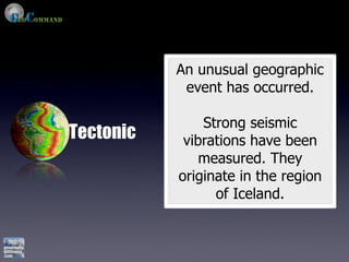
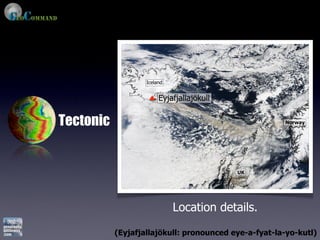
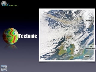
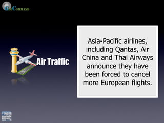
A primary version of GeoCommand - Ash Cloud Shift produced and shared by Shane Speck.
http://www.geographyalltheway.com/recent-geography/geocommand-ash-cloud.htm
A free resource to support geography educators teaching about the recent Eyjafjallajoekull Eruption / Ash Cloud.
Explanation of how the video works within a lesson can be found here:
http://www.geogalot.com/experiences/2010/4/19/eyjafjallajoekull-eruption-ash-cloud-lesson-resources.html
http://www.geographyalltheway.com/recent-geography/geocommand-ash-cloud.htm
Key Stage 3 Geography: The 'New' Wonders of the WorldRichard Allaway
The document lists 20 famous historical and architectural sites from around the world that are considered modern wonders, including the Pyramids of Giza in Egypt, Machu Picchu in Peru, the Taj Mahal in India, the Great Wall of China, and the Sydney Opera House in Australia. These sites range in age from over 5,000 years old for some structures like Stonehenge to as recent as the 20th century for others like the Christ Redeemer statue in Brazil and were built between 3000 BC to 1973 AD.
This document summarizes a presentation about effective environmental communications. It discusses how experts often overestimate the public's understanding of technical terms and confidence in learning them. It also notes that while water issues are a high priority, media consumption habits are changing. The presentation introduces the "Water Words That Work" method, which involves identifying technical terms, encouraging positive action, and replacing jargon with plain language to help the public understand issues and feel empowered to take action.
This presentation discusses how to engage non-traditional audiences in river conservation efforts. It notes that the US population is becoming more diverse, but these groups participate and have knowledge about watersheds at lower rates than average. It recommends using words that focus on family, nature and health when communicating with these audiences. The presentation also suggests using social networks and word-of-mouth instead of traditional media channels to effectively reach non-traditional groups.
This document discusses how to identify influential people in online communities and build relationships with them. It explains that a small percentage of users, called "influentials", are responsible for most information sharing. The key is to provide value to these influentials by supporting and promoting their content, then they will support your content in return. Following basic social etiquette like commenting, sharing links respectfully is important for gaining influence online.
Becoming A Successful Online Ambassador to Online Communitieswaterwordsthatwork
This document discusses how to identify influential people in online communities and build relationships with them. It explains that a small percentage of users, called "influentials", are responsible for most information sharing. The key is to provide value to these influentials by supporting and promoting their content, then they will support your content in return. Following basic social etiquette like commenting, sharing links respectfully is important for gaining influence online.
The document discusses playful embodiment and identity performance on the internet through the use of self-produced photos. It explores how users construct their identity based on interacting and performing using photos of their own body, which is one of the main objects photographed. Examples given include body-blogs and ego-logs where people play with routines, audiences, and present their body and sexuality as a commodity. The practices seem playful through digital image manipulation, posing games, and diverse contextualization of images.
This document summarizes a presentation about effectively communicating water issues to non-experts. It discusses how Americans care about clean water but are confused by technical terms. It then outlines the "Water Words That Work Method" which is a four step approach to translating scientific information into everyday language through identifying technical terms, answering common questions, using understandable words, and avoiding common pitfalls.
The 2010 eruption of the Eyjafjallajökull volcano in Iceland grounded flights across Europe for several weeks, stranding millions of travelers. While volcanic ash poses a serious hazard to aircraft engines, the response to this eruption revealed issues with Europe's preparedness and coordination for such an event. Specifically, the safe ash concentration levels that triggered flight bans were established without scientific basis. Additionally, individual country responses were not well integrated across Europe. Future eruptions, especially of larger volcanoes, could cause significantly longer disruptions, highlighting the need for improved volcanic risk assessment and cross-border emergency planning in Europe.
The document summarizes the 2010 eruption of the Eyjafjallajokull volcano in Iceland. The eruption occurred under a glacier, causing massive ash clouds that rose to 30,000 feet and closed airspace across Europe. This caused major economic disruptions costing airlines over $2 billion. While Iceland suffered some damage like flooded roads and ash-damaged homes, its preparedness as an MEDC with monitoring technology and emergency plans meant the eruption caused no loss of life.
(AQA A2) Plate Tectonics & Associated Hazards Case StudiesJack Hayward
Plate Tectonics & Associated Hazards (AQA A2 Geography) case study mind maps PowerPoint: Case Study mind maps under headings of General Facts, Hazards, Impacts (Social, Economic, Environmental and Political) and Management and Response. Template can be adapted for use on other topics.
The document discusses various natural disasters including hurricanes, volcanoes, earthquakes, and nuclear accidents. It provides details on the 1986 Chernobyl nuclear disaster, describing the explosion at the power plant and the widespread radioactive contamination that resulted. Over 350,000 people were evacuated from affected areas and it is estimated the disaster may eventually cause thousands of cancer deaths.
This document discusses the dangers of nuclear power and radiation. It claims that the nuclear power industry is based on a "hoax" about carbon dioxide driving climate change. It provides examples of how nuclear power plants irradiate large areas with radiation and discusses radioactive waste. It also criticizes the construction of new nuclear reactors in Finland and claims they are being built on a fault line and will leak radiation.
The Chernobyl nuclear disaster of 1986 in Ukraine was the worst nuclear power plant accident in history. When the reactor core was damaged during a safety test, it caused two explosions and released large amounts of radioactive material into the atmosphere. Over 100,000 people had to be evacuated from the surrounding area. Many people suffered long-term health effects such as increased cancer rates, and the environment was also contaminated over a large region. The accident highlighted issues with the Soviet nuclear reactor design and lack of safety precautions that led to the disaster.
A case study on the Eyjafjallajökull Icelandic Eruption of 2010. Suitable for GCSE, AS Level, A Level Geography and beyond. Complete with stunning images.
The document discusses various topics related to environmental pollution and climate change. It provides evidence that glaciers and ice sheets are retreating, sea levels are rising, and greenhouse gas levels like carbon dioxide have increased substantially since the industrial revolution due to human activities. It also discusses other issues like ozone depletion, desertification, pollution in lakes and oceans, and invasive species.
The Eyjafjallajökull volcano in Iceland erupted in 2010, spewing large amounts of ash into the atmosphere. This caused major disruptions to air travel across Europe. Hundreds of thousands of passengers were stranded in airports across multiple countries. The economic damage was estimated at $1.4 billion US dollars. Individual airlines like British Airways and Air France-KLM reported losses of $20 million per day during the most disrupted period. A longer shutdown could have bankrupted some aviation companies. The eruption also disrupted international trade, especially for perishable goods and time-sensitive deliveries that could not withstand delays.
Mount Etna is an active stratovolcano located on the island of Sicily in Italy. It sits on a convergent plate boundary between the African and Eurasian plates. In November 2002, Mount Etna erupted, producing earthquakes, explosions, ash clouds, and two lava flows that destroyed a tourist center and vineyards. The eruption had short term economic impacts like destroying tourism but created fertile soil long term. Monitoring and prediction help minimize damage from such eruptions.
This document discusses the science of climate change and its impacts. It provides evidence that the climate has fluctuated naturally in the past but is now changing due to human activity like burning fossil fuels. This is increasing greenhouse gases and global temperatures, causing sea ice and glaciers to melt, sea levels to rise, and more extreme weather. If emissions are not reduced, significant global impacts are projected this century like worse droughts and storms, flooded coastlines, and threatened ecosystems and food supplies.
This document discusses renewable energy sources and focuses on wind energy. It provides background on wind energy and how wind turbines work, including their anatomy and operation. It also discusses wind farms and the development and impacts of wind energy technology and installations.
The document discusses the climate crisis and outlines several key points:
1) CO2 concentrations in the atmosphere are rising, causing oceans to become more acidic which threatens marine ecosystems.
2) CO2 acts as a greenhouse gas, and human activity since the industrial revolution should have caused 0.7-0.9°C of global warming according to estimates of climate sensitivity.
3) Impacts of sea level rise include threatened small island nations and coastal areas, with estimates of rising sea levels ranging from 50-510 cm by 2100-2300 depending on emissions reductions.
3 luc debontridder climate change and its effects on transport flowsbdm2012
- The document discusses the increasing frequency of extreme weather events like rogue waves and winter storms due to climate change. It may soon be possible to sail directly over the North Pole as Arctic sea ice is rapidly disappearing.
- Rogue waves, which can be over twice the size of surrounding waves, are still not well understood but may result from wave interference or focusing. The Draupner wave in 1995 measured 26 meters high.
- Winter storms in Europe are projected to increase slightly in frequency, while hurricanes in the Atlantic could become more intense with higher rainfall amounts due to warming oceans, though the link remains uncertain.
- As Arctic sea ice reaches record lows, shipping
geographyalltheway.com - IB DP Geography - Global Interactions: KOF Index of ...Richard Allaway
The KOF Index of Globalization was introduced in 2002 by the Swiss Economic Institute and measures the three main dimensions of globalization: economic, political, and social. The economic dimension focuses on trade, investment, and financial flows. The political dimension examines things like diplomatic relations and international organization membership. And the social dimension looks at data on personal contacts, information flows, and cultural proximity. Countries are given an overall index value from 0 to 100 based on these factors, with a higher score indicating greater levels of globalization.
IB Geography - Population Trends and Patterns GraphsRichard Allaway
The document contains graphs showing population trends such as birth rates, death rates, infant mortality rates, fertility rates, and life expectancy across various world regions from 1950 to 2010. Overall, birth rates have declined globally while death rates have also fallen. Infant and child mortality rates have significantly decreased worldwide over this period as well. Life expectancy has risen substantially.
Geographical Association Conference 2012 - 5 Countries ... All you need for I...Richard Allaway
This document discusses using case studies from five countries to teach the IB Geography syllabus. It suggests that five countries with contrasting levels of development could provide examples to illustrate all the key concepts in the course. It then provides guidance from the IB on defining and selecting appropriate case studies, examples, and focus countries. Several potential countries are listed that could fulfill the criteria of having youthful and aging populations, different policies, and represent different regions to teach about patterns and changes in development. Tools for further research on focus countries are also provided.
IB Geography - Food and Health Concept SquaresRichard Allaway
The document discusses the relationships between food, health, and related topics. It presents them as concept squares that show connections between food, balanced diets, disease prevention and treatment, lifestyle, income, trends in food and health since 1950, policymakers, food security, malnutrition, calorie intake, famine, availability of food, changes in agriculture, scientific innovation, the green revolution, the environment, social and economic factors, production and trade of food, subsidies, transnational corporations, food shortages, types of trade, sustainability, and energy efficiency.
IB Geography - Global Interactions Concept MappingRichard Allaway
This document discusses various aspects of global interactions and globalization including economic, environmental, sociocultural, and political dimensions. It examines topics such as the globalization index, time-space convergence, flows of people, money and information, as well as cultural diffusion and anti-globalization movements. The document also explores how global trends impact the local level through concepts like glocalization and the interplay between globalized and non-globalized societies.
IB Geography - Global Interactions - GlocalizationRichard Allaway
Globalization refers to the increasing interdependence of countries through cross-border transactions, capital flows, and technology diffusion. Glocalization emphasizes adapting global products and services to each local culture and market. For example, Taipei McDonald's sells shrimp burgers to appeal to local tastes. The level and rate of globalization adoption varies between places based on factors like economic development, market size, urban/rural contrasts, infrastructure, cultural acceptance, government policies, and local economic activity.
The 2010 eruption of the Eyjafjallajökull volcano in Iceland grounded flights across Europe for several weeks, stranding millions of travelers. While volcanic ash poses a serious hazard to aircraft engines, the response to this eruption revealed issues with Europe's preparedness and coordination for such an event. Specifically, the safe ash concentration levels that triggered flight bans were established without scientific basis. Additionally, individual country responses were not well integrated across Europe. Future eruptions, especially of larger volcanoes, could cause significantly longer disruptions, highlighting the need for improved volcanic risk assessment and cross-border emergency planning in Europe.
The document summarizes the 2010 eruption of the Eyjafjallajokull volcano in Iceland. The eruption occurred under a glacier, causing massive ash clouds that rose to 30,000 feet and closed airspace across Europe. This caused major economic disruptions costing airlines over $2 billion. While Iceland suffered some damage like flooded roads and ash-damaged homes, its preparedness as an MEDC with monitoring technology and emergency plans meant the eruption caused no loss of life.
(AQA A2) Plate Tectonics & Associated Hazards Case StudiesJack Hayward
Plate Tectonics & Associated Hazards (AQA A2 Geography) case study mind maps PowerPoint: Case Study mind maps under headings of General Facts, Hazards, Impacts (Social, Economic, Environmental and Political) and Management and Response. Template can be adapted for use on other topics.
The document discusses various natural disasters including hurricanes, volcanoes, earthquakes, and nuclear accidents. It provides details on the 1986 Chernobyl nuclear disaster, describing the explosion at the power plant and the widespread radioactive contamination that resulted. Over 350,000 people were evacuated from affected areas and it is estimated the disaster may eventually cause thousands of cancer deaths.
This document discusses the dangers of nuclear power and radiation. It claims that the nuclear power industry is based on a "hoax" about carbon dioxide driving climate change. It provides examples of how nuclear power plants irradiate large areas with radiation and discusses radioactive waste. It also criticizes the construction of new nuclear reactors in Finland and claims they are being built on a fault line and will leak radiation.
The Chernobyl nuclear disaster of 1986 in Ukraine was the worst nuclear power plant accident in history. When the reactor core was damaged during a safety test, it caused two explosions and released large amounts of radioactive material into the atmosphere. Over 100,000 people had to be evacuated from the surrounding area. Many people suffered long-term health effects such as increased cancer rates, and the environment was also contaminated over a large region. The accident highlighted issues with the Soviet nuclear reactor design and lack of safety precautions that led to the disaster.
A case study on the Eyjafjallajökull Icelandic Eruption of 2010. Suitable for GCSE, AS Level, A Level Geography and beyond. Complete with stunning images.
The document discusses various topics related to environmental pollution and climate change. It provides evidence that glaciers and ice sheets are retreating, sea levels are rising, and greenhouse gas levels like carbon dioxide have increased substantially since the industrial revolution due to human activities. It also discusses other issues like ozone depletion, desertification, pollution in lakes and oceans, and invasive species.
The Eyjafjallajökull volcano in Iceland erupted in 2010, spewing large amounts of ash into the atmosphere. This caused major disruptions to air travel across Europe. Hundreds of thousands of passengers were stranded in airports across multiple countries. The economic damage was estimated at $1.4 billion US dollars. Individual airlines like British Airways and Air France-KLM reported losses of $20 million per day during the most disrupted period. A longer shutdown could have bankrupted some aviation companies. The eruption also disrupted international trade, especially for perishable goods and time-sensitive deliveries that could not withstand delays.
Mount Etna is an active stratovolcano located on the island of Sicily in Italy. It sits on a convergent plate boundary between the African and Eurasian plates. In November 2002, Mount Etna erupted, producing earthquakes, explosions, ash clouds, and two lava flows that destroyed a tourist center and vineyards. The eruption had short term economic impacts like destroying tourism but created fertile soil long term. Monitoring and prediction help minimize damage from such eruptions.
This document discusses the science of climate change and its impacts. It provides evidence that the climate has fluctuated naturally in the past but is now changing due to human activity like burning fossil fuels. This is increasing greenhouse gases and global temperatures, causing sea ice and glaciers to melt, sea levels to rise, and more extreme weather. If emissions are not reduced, significant global impacts are projected this century like worse droughts and storms, flooded coastlines, and threatened ecosystems and food supplies.
This document discusses renewable energy sources and focuses on wind energy. It provides background on wind energy and how wind turbines work, including their anatomy and operation. It also discusses wind farms and the development and impacts of wind energy technology and installations.
The document discusses the climate crisis and outlines several key points:
1) CO2 concentrations in the atmosphere are rising, causing oceans to become more acidic which threatens marine ecosystems.
2) CO2 acts as a greenhouse gas, and human activity since the industrial revolution should have caused 0.7-0.9°C of global warming according to estimates of climate sensitivity.
3) Impacts of sea level rise include threatened small island nations and coastal areas, with estimates of rising sea levels ranging from 50-510 cm by 2100-2300 depending on emissions reductions.
3 luc debontridder climate change and its effects on transport flowsbdm2012
- The document discusses the increasing frequency of extreme weather events like rogue waves and winter storms due to climate change. It may soon be possible to sail directly over the North Pole as Arctic sea ice is rapidly disappearing.
- Rogue waves, which can be over twice the size of surrounding waves, are still not well understood but may result from wave interference or focusing. The Draupner wave in 1995 measured 26 meters high.
- Winter storms in Europe are projected to increase slightly in frequency, while hurricanes in the Atlantic could become more intense with higher rainfall amounts due to warming oceans, though the link remains uncertain.
- As Arctic sea ice reaches record lows, shipping
Similar to [Primary] GeoCommand - Ash Cloud Shift (16)
geographyalltheway.com - IB DP Geography - Global Interactions: KOF Index of ...Richard Allaway
The KOF Index of Globalization was introduced in 2002 by the Swiss Economic Institute and measures the three main dimensions of globalization: economic, political, and social. The economic dimension focuses on trade, investment, and financial flows. The political dimension examines things like diplomatic relations and international organization membership. And the social dimension looks at data on personal contacts, information flows, and cultural proximity. Countries are given an overall index value from 0 to 100 based on these factors, with a higher score indicating greater levels of globalization.
IB Geography - Population Trends and Patterns GraphsRichard Allaway
The document contains graphs showing population trends such as birth rates, death rates, infant mortality rates, fertility rates, and life expectancy across various world regions from 1950 to 2010. Overall, birth rates have declined globally while death rates have also fallen. Infant and child mortality rates have significantly decreased worldwide over this period as well. Life expectancy has risen substantially.
Geographical Association Conference 2012 - 5 Countries ... All you need for I...Richard Allaway
This document discusses using case studies from five countries to teach the IB Geography syllabus. It suggests that five countries with contrasting levels of development could provide examples to illustrate all the key concepts in the course. It then provides guidance from the IB on defining and selecting appropriate case studies, examples, and focus countries. Several potential countries are listed that could fulfill the criteria of having youthful and aging populations, different policies, and represent different regions to teach about patterns and changes in development. Tools for further research on focus countries are also provided.
IB Geography - Food and Health Concept SquaresRichard Allaway
The document discusses the relationships between food, health, and related topics. It presents them as concept squares that show connections between food, balanced diets, disease prevention and treatment, lifestyle, income, trends in food and health since 1950, policymakers, food security, malnutrition, calorie intake, famine, availability of food, changes in agriculture, scientific innovation, the green revolution, the environment, social and economic factors, production and trade of food, subsidies, transnational corporations, food shortages, types of trade, sustainability, and energy efficiency.
IB Geography - Global Interactions Concept MappingRichard Allaway
This document discusses various aspects of global interactions and globalization including economic, environmental, sociocultural, and political dimensions. It examines topics such as the globalization index, time-space convergence, flows of people, money and information, as well as cultural diffusion and anti-globalization movements. The document also explores how global trends impact the local level through concepts like glocalization and the interplay between globalized and non-globalized societies.
IB Geography - Global Interactions - GlocalizationRichard Allaway
Globalization refers to the increasing interdependence of countries through cross-border transactions, capital flows, and technology diffusion. Glocalization emphasizes adapting global products and services to each local culture and market. For example, Taipei McDonald's sells shrimp burgers to appeal to local tastes. The level and rate of globalization adoption varies between places based on factors like economic development, market size, urban/rural contrasts, infrastructure, cultural acceptance, government policies, and local economic activity.
geographyalltheway.com - IB Geography - Food and Health - Prevention or Trea...Richard Allaway
Coronary heart disease is a major cause of death in the UK. Risk factors include high BMI, diabetes, smoking, poor diet, lack of exercise, stress, and family history. The British Heart Foundation is a charity focused on preventing heart disease through research, education, and support for patients. Prevention efforts target reducing obesity and smoking rates through public health initiatives and lifestyle changes.
geographyalltheway.com - IB Geography - The Bradshaw ModelRichard Allaway
The document describes how characteristics of a river channel change from upstream to downstream. It explains that discharge, occupied channel width, channel depth, and average velocity all increase downstream as the drainage basin and input to the river increases. Channel depth and width increase to accommodate higher discharges. Average velocity increases downstream because the river becomes more efficient with less contact with its bed and banks, shown by a higher hydraulic radius and lower channel bed roughness.
Uranium mining is a major industry and employer in Niger, with the country being the fourth largest producer globally in 2006. However, the mining poses challenges due to the harsh desert environment requiring infrastructure development and raising concerns about water usage and potential contamination. While mining provides economic opportunities, it has also led to population growth in mining towns and debates around its environmental impacts.
geographyalltheway.com - IB Geography - Patterns and Change Mega Mind MappingRichard Allaway
The document discusses various patterns related to population, development, environment, and resources. It addresses topics like Millennium Development Goals, core and periphery, populations in transition regarding birth/death rates and youth/aging populations, disparities in wealth and development, trade and factors influencing environmental quality and sustainability, and patterns in resource consumption focusing on conservation.
Geographical Conference 2011 - A teacher’s perspective of IB GeographyRichard Allaway
The document discusses the benefits of an IB Geography curriculum from a teacher's perspective. It outlines the IB learner profile which emphasizes developing internationally minded and principled students. It then discusses using a themed approach to syllabus delivery in Geography, with themes like human interaction and challenges. This approach engages students and enables flexibility compared to more linear models. Some benefits discussed for students include progressing their knowledge in a way that is not isolated and encourages change.
The Demographic Transition Model describes 5 stages of demographic change that occur as countries develop economically from pre-industrial to industrialized societies. In the first two stages, birth and death rates are high due to lack of modern medicine and sanitation. In the third stage, death rates decline as living standards rise, while birth rates remain high. In the fourth stage, birth rates fall due to family planning and women's education. The final stage is characterized by low birth and death rates and a stable population.
geographyalltheway.com - IB Geography: Neo-Malthusian and anti-MalthusianRichard Allaway
The document discusses two opposing views on the relationship between population growth and resource consumption:
1. Neo-Malthusians argue that population grows exponentially while resources increase arithmetically, eventually leading to overconsumption and collapse as advocated by Thomas Malthus, Paul Ehrlich, and the Club of Rome model.
2. Anti-Malthusians like Ester Boserup and Julian Simon believe that population pressure stimulates technological innovation and more efficient resource use, allowing food production and living standards to continue increasing indefinitely. They argue resources are not physically limited if old ones can be recycled and new alternatives developed.
This document provides possible stimulus materials for an IB Geography exam, including maps and diagrams sourced from maps.grida.no. It suggests using maps and diagrams as potential sources for exam questions. The document is brief and does not provide much context around the purpose or format of the possible exam.
This document outlines an introduction session about geography's place in the International Baccalaureate. It includes an introduction by Simon Oakes on the IB and geography followed by Richard Allaway breaking down the geography course with practical suggestions. It concludes with an open floor for questions.
The document discusses the International Baccalaureate (IB) Diploma Programme, including its geography component. It notes that the IB DP is a globally recognized university entrance qualification offered in over 2,300 schools across 128 countries. The IB DP geography curriculum focuses on global issues, sustainability, and developing international perspectives. It involves studying core topics, optional themes, and global interactions, and is assessed through written exams and fieldwork.
Geographical Association Conference 2011 - geographyalltheway.com - Resourcin...Richard Allaway
This document outlines the agenda for an IB Geography workshop. It will cover the main textbook options A through D, additional supplemental materials, the top 10 online resources, and opportunities for professional development in IB Geography. Attendees will also have a chance to participate in a treasure hunt of online resources and enter a raffle for printed materials.
Japan's population is aging and declining, so the government is implementing policies and campaigns to encourage citizens to have more children. These include providing financial support for families with children through tax breaks and subsidies for health care, education, and paternity leave. Artificial insemination options are also being promoted as more affordable and accessible for couples struggling with fertility issues or who want children but lack a partner. Public messaging emphasizes that having children is now easier and more financially feasible due to these government programs.
The Deepwater Horizon oil rig exploded in the Gulf of Mexico 1,500 meters below the surface and 66 km off the coast of Louisiana, killing 11 workers. Over the next 36 hours, the rig burned and eventually sank, leaving a damaged wellhead that was leaking oil into the Gulf. For months, oil gushed from the wellhead at an estimated rate of up to 40,000 barrels per day, spreading across 1,500 square km of the Gulf and reaching the coasts of Louisiana, Florida, and elsewhere in the Gulf region due to ocean currents. The well was finally capped on July 15, over 80 days after the initial explosion.
IB Geography: Patterns and Change > Ravenstein's LawsRichard Allaway
The document discusses several models of migration including Ravenstein's Laws and Lee's Migration Model. Ravenstein's Laws are a set of predictive statements about migration patterns in the UK in the 1880s, including that most migrants move short distances, people in rural areas migrate more than urban dwellers, and migration typically occurs in stages. Lee's Migration Model visually depicts the movement of people between locations and the impact of intervening obstacles.
Walmart Business+ and Spark Good for Nonprofits.pdfTechSoup
"Learn about all the ways Walmart supports nonprofit organizations.
You will hear from Liz Willett, the Head of Nonprofits, and hear about what Walmart is doing to help nonprofits, including Walmart Business and Spark Good. Walmart Business+ is a new offer for nonprofits that offers discounts and also streamlines nonprofits order and expense tracking, saving time and money.
The webinar may also give some examples on how nonprofits can best leverage Walmart Business+.
The event will cover the following::
Walmart Business + (https://business.walmart.com/plus) is a new shopping experience for nonprofits, schools, and local business customers that connects an exclusive online shopping experience to stores. Benefits include free delivery and shipping, a 'Spend Analytics” feature, special discounts, deals and tax-exempt shopping.
Special TechSoup offer for a free 180 days membership, and up to $150 in discounts on eligible orders.
Spark Good (walmart.com/sparkgood) is a charitable platform that enables nonprofits to receive donations directly from customers and associates.
Answers about how you can do more with Walmart!"
How to Make a Field Mandatory in Odoo 17Celine George
In Odoo, making a field required can be done through both Python code and XML views. When you set the required attribute to True in Python code, it makes the field required across all views where it's used. Conversely, when you set the required attribute in XML views, it makes the field required only in the context of that particular view.
Philippine Edukasyong Pantahanan at Pangkabuhayan (EPP) CurriculumMJDuyan
(𝐓𝐋𝐄 𝟏𝟎𝟎) (𝐋𝐞𝐬𝐬𝐨𝐧 𝟏)-𝐏𝐫𝐞𝐥𝐢𝐦𝐬
𝐃𝐢𝐬𝐜𝐮𝐬𝐬 𝐭𝐡𝐞 𝐄𝐏𝐏 𝐂𝐮𝐫𝐫𝐢𝐜𝐮𝐥𝐮𝐦 𝐢𝐧 𝐭𝐡𝐞 𝐏𝐡𝐢𝐥𝐢𝐩𝐩𝐢𝐧𝐞𝐬:
- Understand the goals and objectives of the Edukasyong Pantahanan at Pangkabuhayan (EPP) curriculum, recognizing its importance in fostering practical life skills and values among students. Students will also be able to identify the key components and subjects covered, such as agriculture, home economics, industrial arts, and information and communication technology.
𝐄𝐱𝐩𝐥𝐚𝐢𝐧 𝐭𝐡𝐞 𝐍𝐚𝐭𝐮𝐫𝐞 𝐚𝐧𝐝 𝐒𝐜𝐨𝐩𝐞 𝐨𝐟 𝐚𝐧 𝐄𝐧𝐭𝐫𝐞𝐩𝐫𝐞𝐧𝐞𝐮𝐫:
-Define entrepreneurship, distinguishing it from general business activities by emphasizing its focus on innovation, risk-taking, and value creation. Students will describe the characteristics and traits of successful entrepreneurs, including their roles and responsibilities, and discuss the broader economic and social impacts of entrepreneurial activities on both local and global scales.
A Visual Guide to 1 Samuel | A Tale of Two HeartsSteve Thomason
These slides walk through the story of 1 Samuel. Samuel is the last judge of Israel. The people reject God and want a king. Saul is anointed as the first king, but he is not a good king. David, the shepherd boy is anointed and Saul is envious of him. David shows honor while Saul continues to self destruct.
Leveraging Generative AI to Drive Nonprofit InnovationTechSoup
In this webinar, participants learned how to utilize Generative AI to streamline operations and elevate member engagement. Amazon Web Service experts provided a customer specific use cases and dived into low/no-code tools that are quick and easy to deploy through Amazon Web Service (AWS.)
This presentation was provided by Rebecca Benner, Ph.D., of the American Society of Anesthesiologists, for the second session of NISO's 2024 Training Series "DEIA in the Scholarly Landscape." Session Two: 'Expanding Pathways to Publishing Careers,' was held June 13, 2024.
Chapter wise All Notes of First year Basic Civil Engineering.pptxDenish Jangid
Chapter wise All Notes of First year Basic Civil Engineering
Syllabus
Chapter-1
Introduction to objective, scope and outcome the subject
Chapter 2
Introduction: Scope and Specialization of Civil Engineering, Role of civil Engineer in Society, Impact of infrastructural development on economy of country.
Chapter 3
Surveying: Object Principles & Types of Surveying; Site Plans, Plans & Maps; Scales & Unit of different Measurements.
Linear Measurements: Instruments used. Linear Measurement by Tape, Ranging out Survey Lines and overcoming Obstructions; Measurements on sloping ground; Tape corrections, conventional symbols. Angular Measurements: Instruments used; Introduction to Compass Surveying, Bearings and Longitude & Latitude of a Line, Introduction to total station.
Levelling: Instrument used Object of levelling, Methods of levelling in brief, and Contour maps.
Chapter 4
Buildings: Selection of site for Buildings, Layout of Building Plan, Types of buildings, Plinth area, carpet area, floor space index, Introduction to building byelaws, concept of sun light & ventilation. Components of Buildings & their functions, Basic concept of R.C.C., Introduction to types of foundation
Chapter 5
Transportation: Introduction to Transportation Engineering; Traffic and Road Safety: Types and Characteristics of Various Modes of Transportation; Various Road Traffic Signs, Causes of Accidents and Road Safety Measures.
Chapter 6
Environmental Engineering: Environmental Pollution, Environmental Acts and Regulations, Functional Concepts of Ecology, Basics of Species, Biodiversity, Ecosystem, Hydrological Cycle; Chemical Cycles: Carbon, Nitrogen & Phosphorus; Energy Flow in Ecosystems.
Water Pollution: Water Quality standards, Introduction to Treatment & Disposal of Waste Water. Reuse and Saving of Water, Rain Water Harvesting. Solid Waste Management: Classification of Solid Waste, Collection, Transportation and Disposal of Solid. Recycling of Solid Waste: Energy Recovery, Sanitary Landfill, On-Site Sanitation. Air & Noise Pollution: Primary and Secondary air pollutants, Harmful effects of Air Pollution, Control of Air Pollution. . Noise Pollution Harmful Effects of noise pollution, control of noise pollution, Global warming & Climate Change, Ozone depletion, Greenhouse effect
Text Books:
1. Palancharmy, Basic Civil Engineering, McGraw Hill publishers.
2. Satheesh Gopi, Basic Civil Engineering, Pearson Publishers.
3. Ketki Rangwala Dalal, Essentials of Civil Engineering, Charotar Publishing House.
4. BCP, Surveying volume 1
Level 3 NCEA - NZ: A Nation In the Making 1872 - 1900 SML.pptHenry Hollis
The History of NZ 1870-1900.
Making of a Nation.
From the NZ Wars to Liberals,
Richard Seddon, George Grey,
Social Laboratory, New Zealand,
Confiscations, Kotahitanga, Kingitanga, Parliament, Suffrage, Repudiation, Economic Change, Agriculture, Gold Mining, Timber, Flax, Sheep, Dairying,
BÀI TẬP BỔ TRỢ TIẾNG ANH LỚP 9 CẢ NĂM - GLOBAL SUCCESS - NĂM HỌC 2024-2025 - ...
[Primary] GeoCommand - Ash Cloud Shift
1.
2.
3.
4. Welcome to your shift at
GeoCommand -
the European Geographical
Advisory Service.
You are in for a busy shift!
5.
6. Your job is to operate
the 140 Console.
The 140 Console
broadcasts news updates.
Each update is a maximum of
140 characters.
7.
8. You will receive updates from four
different information streams.
Air Traffic Meteorology
Tectonic Health
9.
10. This sound announces
a new update.
This sound requests a new
140 Console update.
You will be asked to produce
140 Console updates
about certain topics.
24. On 26th February 2010,
unusual seismic activity
along with rapid
Tectonic expansion of the Earth's
crust was registered by
the Meteorological
Institute of Iceland.
33. The eruption is the first
in Iceland since 2004.
Tectonic It is the first eruption
near Eyjafjallajökull
since 1823.
(Eyjafjallajökull: pronounced eye-a-fyat-la-yo-kutl)
48. The last eruption in
the Eyjafjallajökull
glacier, in 1821,
Tectonic caused serious
flooding as the ice
melted.
(Eyjafjallajökull: pronounced eye-a-fyat-la-yo-kutl)
81. In the past 10 years,
more than 90 aircraft
have suffered damage
Air Traffic from volcanic ash,
according to the
International Civil
Aviation Authority.
105. Fruit is pre-sliced in
African facilities and
flown in. This means
that even if companies
Air Traffic could organise other
workers, the fruit isn’t
even in the right
country.
123. Dangerous toxic fumes
are in the air in the
immediate surroundings
Health of the volcanic crater,
which can cause
permanent damage to
the lungs if inhaled.
129. Ingi Thor Jakobsson,
manager of the Hotel Rangá
located near the
Eyjafjallajökull glacier:
Tectonic “I hope the eruption
continues for a while
because it is very good
for business”
(Eyjafjallajökull: pronounced eye-a-fyat-la-yo-kutl)
132. Ingi Thor Jakobsson,
manager of the Hotel Rangá:
“There aren't a lot of
Tectonic four star restaurants
that can offer dinner
and a view of a volcanic
eruption”
138. According to Adolf
Arnason, a police
officer at Hvolsvöllur
(the closest police
Tectonic station to the
eruption), the area has
seen a sharp increase
in visitors this week.
141. Most of the country
remains unaffected by
falling ash but south of
the volcano, visibility
Meteorology has been reduced to
almost zero. Conditions
are described as
‘extremely unpleasant’.
147. The event is described
as "a major business
and economic disaster"
Air Traffic particularly with several
European airlines
already facing financial
difficulties.
150. The Icelandic
Meteorological Office
says that the light winds
prevailing in Europe and
large amounts of
Meteorology unmelted glacial ice
above the volcano
means the situation is
unlikely to change over
the next few days.
153. CO2 Emissions
European Aviation Industry Eyjafjallajökull
350,000 tons of CO2 per day 150,000 tons of CO2
produced per day
200,000 tons of CO2 saved by 60%
cancelled flights across Europe
Meteorology
159. Most families with
children who are living
in the fallout zone have
Health chosen to leave. Those
that remain are mostly
farmers with livestock to
look after.
162. Air Traffic
The ash cloud is expected to spread across
Europe over the course of several days. There
will be considerable disruption to air traffic.
170. This simulation has been based
on real events and information.
You should now have a better
understanding of the consequences
of a volcanic eruption.
You should also understand more about
what Geographers actually do.