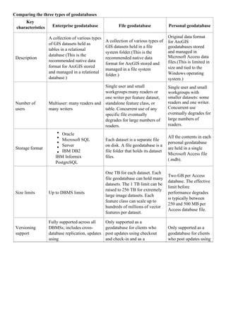
1. Comparing the three types of geodatabases
Key
characteristics Enterprise geodatabase File geodatabase Personal geodatabase
Description
A collection of various types
of GIS datasets held as
tables in a relational
database (This is the
recommended native data
format for ArcGIS stored
and managed in a relational
database.)
A collection of various types of
GIS datasets held in a file
system folder.(This is the
recommended native data
format for ArcGIS stored and
managed in a file system
folder.)
Original data format
for ArcGIS
geodatabases stored
and managed in
Microsoft Access data
files.(This is limited in
size and tied to the
Windows operating
system.)
Number of
users
Multiuser: many readers and
many writers
Single user and small
workgroups:many readers or
one writer per feature dataset,
standalone feature class, or
table. Concurrent use of any
specific file eventually
degrades for large numbers of
readers.
Single user and small
workgroups with
smaller datasets: some
readers and one writer.
Concurrent use
eventually degrades for
large numbers of
readers.
Storage format
Oracle
Microsoft SQL
Server
IBM DB2
IBM Informix
PostgreSQL
Each dataset is a separate file
on disk. A file geodatabase is a
file folder that holds its dataset
files.
All the contents in each
personal geodatabase
are held in a single
Microsoft Access file
(.mdb).
Size limits Up to DBMS limits
One TB for each dataset. Each
file geodatabase can hold many
datasets. The 1 TB limit can be
raised to 256 TB for extremely
large image datasets. Each
feature class can scale up to
hundreds of millions of vector
features per dataset.
Two GB per Access
database. The effective
limit before
performance degrades
is typically between
250 and 500 MB per
Access database file.
Versioning
support
Fully supported across all
DBMSs; includes cross-
database replication, updates
using
Only supported as a
geodatabase for clients who
post updates using checkout
and check-in and as a
Only supported as a
geodatabase for clients
who post updates using