1. 1. About us
GAVRIEL is a new entrant in the sector set to uniquely provide
all Land Surveying, Mapping, Geo-information solutions in
ways that are innovative, efficient and effective.
2. Vision
To be known by works
3. Values
• Long-term relationships
• Integrity
• Reliability
• Expertise
• Quality
b) To carry out Global Positioning Systems
(GPS) and geodetic surveys;
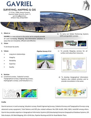
c) To provide Mapping services for all
surface and subsurface resources;
Pipeline Survey-ROW
d) To develop Geographical Information
Systems plus related activities and to
provide consultation in the same;
4. Services
a) Locational surveys, Cadastral surveys,
Topographical surveys, Engineering surveys,
Hydrographic surveys, Land Valuation e.t.c;
Profile
Gavriel ventures in Land surveying, Valuation surveys, Roads Engineering Surveys, Cadastral Surveys and Topographical Surveys using
advanced survey equipment; Total Stations and GPS plus related software like ESRI ArcGIS, ENVI, QGIS, AutoCAD among others.
Gavriel also provides expertise in Geographical Information Systems (GIS) developing Enterprise Geographical Database Systems, GIS
Data Analysis, GIS Web Mapping, GIS in Oil & Gas, Pipeline Routing and GIS for Road Master Plans.
SURVEYING, MAPPING & GIS
P. O. Box 12806, Mengo Kampala
Opposite Ndejje University, Room 13
gavriel.ug@gmail.com
0785221966, 0706678981