SlideShare a Scribd company logo
1 | P a g e
SERVICES PROFILE
2 | P a g e
Table of Contents:
 WHO WE ARE
 WHAT WE OFFER
 HSE POLICY
 BUSINESS STRATEGY AND STEERING PLANNING
 GIS STRATEGIC IMPLEMENTATION PLANNING
 SERVICE WE PROVIDE
 GIS IMPLEMENTATION SERVICES
 DATA CREATION SERVICES
 ADVANCED PUBLIC SAFETY GIS SOLUTION
 ENTERPRISE GIS SOFTWARE FOR LOCAL GOVERNMENT
 GEO DATA BASE DESIGN
 GIS – IT INTEGRATION
 APPLICATION DEVELOPMENT SOLUTIONS
 GOLBAL POSITIONING SYSTEMS (GPS) FIELD INVENTORY
 GIS & AM/FM
 GPS MAPPING AND FIELD INVENTORY
 JOINT USE INVENTORY
 METER REPLACEMENT
 DATA MAINTENANCE
 PRINTING, PLOTTING, SCANNING AND TRUCK MAP IMAGING
 DATABASE MODELING SETUP AND ADMINISTRATION
 CUSTOM IMAGERY
 PARCEL MAPPING
 CUSTOM PROGRAMMING
 TRAINING AND SUPPORT
 GPS FIELD COLLECTION USING ARCPAD
 GIS ARCHITECTURAL DESIGN AND IMPLEMENTATION
 GIS DATA SUPPORT
 GIS SUCCESS STORIES
 STC (SAUDI TELECOM COMPANY) VDSL POWER PROJECT – WITH GIS SURVEY
 SEC (SAUDI ELECTRIC COMPANY) GIS PROJECT
 GIS TRAINING
 CONTACT US
 OUR VALUED CLIENTS
3 | P a g e
Who we are
Geographic Technologies Division (JAZERA ACCESS) is one of the country’s leading full-service local
government GIS consulting companies with its main office located in Riyadh (KSA). JAZERA ACCESS has secured
state, national, and international awards for products and services; built on its tradition of deploying the very best
GIS solutions for local government, health, education and telecom sector. JAZERA ACCESS holds clients nationwide in
Saudi Arabia and internationally present in Pakistan, Bahrain, UAE and USA. A corporate culture of quality,
understanding, and commitment to our clients allows JAZERA ACCESS to continue to build an outstanding local
government GIS portfolio.
What We Offer
• GIS COMPLETE SOLUTIONS
• CONSULTANCY
• NETWORK SURVEY & AUDIT
• ASSET’S GEO TAGGING
• UNDERGROUND UTILITY RESOURCES MANAGEMENT
• FIXED NETWORK SOLUTIONS
• GSM SOLUTIONS (INSTALLTION & COMMISSIONING )
• SYSTEM DESIGN & ENGINEERING
• PROJECT MANAGEMENT
• POWER SERVICES
• OPERATION & MAINTENANCE
A Leader in Strategic GIS Planning
JAZERA ACCESS has a unique strategic planning methodology and ability to explore new ways for Clients to use GIS
technology to improve efficiency, increase productivity, and save time, lives, and money. As the country’s leading
experts in GIS strategic planning, JAZERA ACCESS delivers tailored solutions for towns, cities, and counties
throughout the Saudi Arabia, and has outstanding references. Supporting this unique approach is the outstanding
ability of the company to present GIS as an invaluable tool for Clients, and develop understandable step-by-step
implementation guidelines for our clients.
HSE Policy
Since we deal with high power and work in open environment, we are committed to ensure the health and safety of
our employees and field staff, and protecting the environment and the communities in which we operate. Meeting
this commitment is a primary management objective as well as the individual and collective responsibility of all
employees.
We will achieve this through:
 Complying with all relevant legal and other requirements;
 Caring for the health and safety of our employees by providing adequate resources;
 Creating a safe, healthy and environmental-friendly workplace by motivating all employees to take personal
accountability.
 Continuously improving the management system and practices
4 | P a g e
Business Strategy and Steering Planning
GIS Strategic Implementation Planning
Geographic Technologies division (JAZERA ACCESS-JA-) has been helping local governments harness the
power of geographic information systems though careful planning, intelligent implementation, and expert guidance
at every phase of the process. JAZERA ACCESS® was founded specific call to help towns, cities, and counties of all
sizes design, build, and implement cost effective GIS technology. Whether your organization is just beginning to
explore GIS, or you have a mature, robust program, JAZERA ACCESS can take you to the next level. We’d like to be
your partner to build a rich and prosperous future for your community and its citizens.
The opportunities are limitless with effective GIS solutions, and JAZERA ACCESS can make those opportunities viable.
GIS Services we provide
While providing GIS Mapping Services, JAZERA ACCESS maintains a commitment to state-of-the-industry
technology, research and innovation, implemented by highly experienced and qualified staff. Our team of engineers,
geo-scientists, planners has developed GIS products and systems, integrated with GPS, GIS, and CAD. Our
commitment and continuous effort for customer satisfaction have made JAZERA ACCESS a well-known and reliable
GIS Data Conversions Service provider.
GIS Implementation Services
JAZERA ACCESS offers the very best cadre of experts in geospatial technologies. Success of GIS depends on
many factors, including the creation and maintenance of accurate and reliable GIS data and databases. JAZERA
ACCESS offers a complete range of geospatial services including:
Our GIS Data Conversions Services include the following:
 GIS Services in System Design and Architecture
 GIS Services Management and Maintenance
 Map Production and Analysis (specialized for GIS Mapping Agencies also)
 Database Design and Development
 GIS Applications Development (GIS Mapping and GIS Remote Sensing)
 GIS Mapping User Training and Support
 3D Modeling and Visualization for GIS Mapping Products and GIS Remote Sensing Products
 Architectural CAD Drafting
 Our Expertise
 Experts in GIS for Utilities
5 | P a g e
Towns, cities, and counties across the Saudi Arabia face the challenges of effective infrastructure
management. Having timely and accurate infrastructure location data is critical to the success of any utility initiative.
JAZERA ACCESS offers expert consulting services for the planning, design, and implementation of utility-based
projects, and a full suite of enterprise software. JAZERA ACCESS’s GIS utility experts are working on many utility
projects including: water systems, waste water, storm water, electric, telecom and gas.
Data Creation Services
JAZERA ACCESS works with organizations to convert paper and digital information into meaningful and
reliable GIS database layers. Our services include digitizing, scanning, geo-referencing, GPS, data interpolation, and
integration, and assuring data quality using sophisticated techniques.
Advanced Public Safety GIS Solutions
JAZERA ACCESS provides integrated GIS software for public safety agencies including: Police, Sheriff, Fire,
and Emergency Medical Services. Experienced public safety and emergency response GIS experts plan design and
implement a full range of practical, cost-effective GIS software solutions including:
• Address Management
• Mobile
• AVL
• Crimes
• Dispatch
• Emergency Notification
• Routing
• Fires
Enterprise GIS Software for Local Government
JAZERA ACCESS’s ultimate mission is to deliver affordable, easy-to-use geo-spatial integrated software
solutions to every department within local government. JAZERA ACCESS’s enterprise products empower local
government professionals with the ability to view, manage, analyze, distribute, and publish data. JAZERA ACCESS’s
full suite of GIS software is distinguished by its user-friendliness, speed, and precision.
JAZERA ACCESS’s new suite of software is focused on centrally managed and enterprise GIS solutions built
on ESRI’s ArcGIS Server technology. JAZERA ACCESS’s software products serve every sector and include intranet,
Internet, mobile, and touch screen solutions.
A comprehensive and reliable implementation of GIS technology often includes the training and educating
your organization, the design of a reliable and repeatable GIS database, and the building of meaningful digital data.
It also includes Information Technology (IT) framework design and implementation, application design, and software
integration and deployment. Geographic Technologies Division (JAZERA ACCESS-JA) professional services staff offer
the following extensive Utilities’ services.
6 | P a g e
JAZERA ACCESS has the capabilities to create GIS layers from many formats whether it is in database format or in
hard copy format.
7 | P a g e
Geo-Database Design
We have proven expertise in the design and implementation of enterprise-wide GIS databases. True
enterprise-wide databases are fully integrated with ESRI applications, external models, and system operations. A
dedicated strategy for the design and deployment of a logical and physical database is being used for many
organizations. Our database design strategies include:
Enterprise GIS database design requires consideration of existing technology and multiple department
requirements.
GIS/IT Integration
Integrating GIS software with existing technology is a priority for almost all organizations. We help agencies
enhance their capabilities and maximize their current technology investments by integrating geo-spatial
functionality with existing applications. We have spatially enabled hundreds of software systems including:
8 | P a g e
Application Development Solutions
Our professionals services include design, customization, and deployment of true enterprise-wide software solutions
including desktop GIS, Web GIS, departmental intranet GIS, portable (hand-held) GIS tools and touch screen GIS technology.
Global Positioning Systems (GPS) Field Inventory
Our professionals use GPS technology to build accurate digital GIS data. JAZERA ACCESS helps our clients
design and collects important infrastructure information; include street centerlines, and address points, signage,
trees, sidewalks and facilities.
When there is little or no source data, JAZERA ACCESS still has the capabilities to create the GIS layers that are
needed.
GIS & AM/FM
GIS Landmark is experienced using multiple GIS platforms including AutoCAD, ArcInfo, Micro station and
MapInfo. We specialize in utility mapping which consists of many different services including full system digitization,
system modeling, land base creation, revisions, work order updates, circuit map creation, map conversion, raster to
vector just to mention a few.
9 | P a g e
GPS Mapping & Field Inventory
GIS Landmark provides GPS mapping and field inventory for all utility types. We also provide training and
data dictionary setup for our clients in the case they prefer to perform the field work themselves. Our staff is
experienced with a number of global positioning system (GPS) brands and manual facilities inventory techniques.
Using the ESRI mobile mapping software ArcPad and ArcPad Application Builder we are able to create user friendly
forms for data collection to meet our individual client needs.
Joint Use Inventory
GIS Landmark provides detailed joint use inventory services for utility companies. We use the latest greatest
technology along with skilled field technicians. In most cases we use the Ricoh GPS digital camera to record photos
and location of each contact. We take these photos and load them into the GIS which give a very accurate location
as well as a hyperlink in your GIS to the photo from the pole feature class. We collect all required attribute
information about the joint-use contacts and can provide in many different formats compatible with all GIS software
platforms.
Meter Replacement
GIS Landmark provides turnkey services to perform meter change-out programs that meet the requirements of our
customers, as well as any regulatory agencies. We have worked with numerous clients to develop programs to
achieve their service and budget goals. This effort is successfully accomplished with minimal disruption to the
utility’s work environment and its valued customers.
Data Maintenance
Utilities often recognize that data maintenance is not a core competency within their operation and is, in fact, a
distraction that keeps qualified people away from mission critical jobs. Data maintenance is like housework, it’s
tedious, time consuming and is never finished. GIS Landmark provides a variety of data maintenance services for our
clients. We have experience reading work orders for updating and understand most construction codes used by
utility companies today. We will provide a GIS Landmark representative on-site if desired for these updates or they
can be done remotely from our main office.
Printing, Plotting, Scanning & Truck Map Creation
At GIS Landmark we provide high quality B/W or color maps. We can plot many different sizes and on all types of
paper (plain and glossy paper, vellum and transparent film) to fit your needs. We can plot large wall key maps for
your main call center which comes in handy during outages. We also provide scanning services in B/W and color at a
very high quality. We can produce bound truck maps at any size to use in the field and digital maps on CD for use on
laptops.
10 | P a g e
Database Modeling Setup & Administration
The GIS data model is a complex definition of each point, line and polygon in the system and identifies the
relationships between those objects. Data stored in the database describes information about these objects and
how they are managed in the GIS. The database design must be compatible with existing data, meet the needs of
the organization, support end-user applications, be dynamic and grow with the system, and avoid duplication and
redundancy. Database tables and fields must be designed to effectively integrate with other in house systems such
as billing, engineering and trouble call packages. The data structures must be compatible in order to communicate
from one application to another. GIS Landmark provides database design and administration services for our clients.
We are experienced in preparing databases to correspond with all applications.
Custom Imagery
Aerial and satellite imagery can improve your GIS system dramatically. It gives you the ability to automatically view
subdivisions, rights of way, roads, waterways, buildings and facilities from your GIS system. Generally speaking
imagery can be more current, less costly, and quicker to implement than traditional base mapping applications,
particularly for larger service areas. Our image analysts are very experienced and can help you determine what is
right for you.
Parcel Mapping
GIS Landmark can build an accurate land base using GPS Image BASE as the first step in the process. Then we can
scan the clients existing paper parcel maps into the mapping system and geo-referenced to match the GPS Image
BASE. If Scanning isn’t an option then we have the ability to draw the parcel maps to scale manually using
coordinate geometry (COGO) techniques, while geo-referencing to the GPS Image BASE as we go. We also link the
parcel polygon to a database record for easy look up and management.
Custom Programming
Once a GIS has been populated with data; end-users will need to access that data. Out-of-the-box GIS tools don’t
always align with company operations and many utility company’s decide to develop specific programs (called
applications) to assist staff updates and use the GIS data efficiently and effectively. In addition to company-specific
applications, general GIS applications include tools designed to view and query the GIS data layers, generate
predefined and ad hoc plots and reports, extract specific layers for project-specific work, and update, revise and
maintain existing GIS data layers. GIS Landmark has the expertise to design and implement custom programs to fit
our client’s needs for any of the GIS software applications.
Training & Support
We provide an array of training and consulting services for our clients. The training services provided by GIS
Landmark depend on the specific needs of the individual client. We have a professional staff that has years of
experience in many different aspects of GIS and utility mapping.
11 | P a g e
GPS FIELD COLLECTION USING ARCPAD
12 | P a g e
GIS Architectural Design and Implementation
The backbone of any successful GIS is the IT infrastructure. Our team offers in-depth knowledge and
understanding of systems integration, hardware, software, operating systems, networking, and peripheral devices.
JAZERA ACCESS has experience in all phases of implementation and can assist from the initial Needs Assessment and
budget creation to the complete implementation.
A truly effective GIS integrates software with existing technology.
GIS Data Support
The GIS Data Support packages offer full, off-site support related to the management of GIS data. Our GIS
professionals will spend a pre-determined number of days to help develop, update, and maintain your GIS data in
order to meet your specific needs. We can assist with address point updates, street centerline editing, and even
aerial photo conversion depending on what you need. Since GIS data is the foundation upon which your systems are
built, accurately maintaining it is often very critical. Let JAZERA ACCESS do the work for you. Keep your data up-to-
date with our GIS Data Support packages and feel good about staying on track.
13 | P a g e
GIS Success Stories
STC (Saudi Telecom Company) VDSL POWER PROJECT – WITH GIS SURVEY
Jazera Access have already accomplished successfully the STC’s one of the huge projects named VDSL (Very
High-speed Digital Subscriber’s Line) Power Project and provided complete power solution Kingdom wide
for more than 3000 sites of STC.
It’s a one of STC’s biggest projects and Jazera Access is completing it very successfully and already provided
power through SEC (Saudi Electric Company) and connected more than 850 sites Kingdom Wide.
Which is a proof that Jazera Access is capable of providing all kinds of power solution starting from
Consultancy till Execution of the whole project as and where needed?
One Source for your Power needs:
14 | P a g e
Jazera Access started with STC as a Consultant of VDSL Project and during consultancy STC decided to give
JA full charge of the project from Consultancy to Project Management.
It was quite a big task and very difficult project in which many official sectors were involve and the
productivity is needed on time.
First of all its JA important part as an consultant was to provide the clear picture of all sites and available
power source of SEC (Saudi Electric Company) and to match the needs of STC as well as to maintain and
meet the SEC Standards for all 3000 sites.
JA played very vital role to provide mutual acceptance through powerful expertise and JA was like bridge
between STC and SEC and approved the necessary design from SEC for the final implementation of the STC
Power Project.
As we said before the project was quite difficult due to many of the official departments were involve and
to reach the maximum productivity in shortest time it should be handled smartly.
15 | P a g e
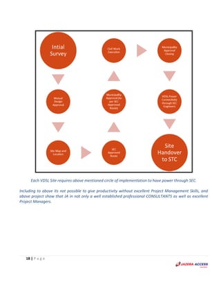
So, to make that possible it needs a circle of procedures to complete each site smoothly ending up with
power, which are as follows:
1. GIS Survey (Site by Site and allocating the SEC source of power)
2. Approved Design (SEC and STC)
3. Site Map and Location (Indicating Source to have Approved Source Route of SEC)
4. SEC Approved Route
5. Baladia Approval (As per SEC Approved Route)
6. Civil Work Execution (Trenching/Excavation from SEC Source to Cabinet to lay the Cable as per
SEC approved standards)
7. Baladia Approval Closing(After Completion of Civil Work)
8. VDSL Power Connectivity through SEC Engineers.
9. Site Handover to STC’s concerned to Assigned Offices.
Figure 1: Initial Map (After GIS Survey)
16 | P a g e
Figure 2: SEC Approved Route
Figure 3: SEC Approved Route & Design
17 | P a g e
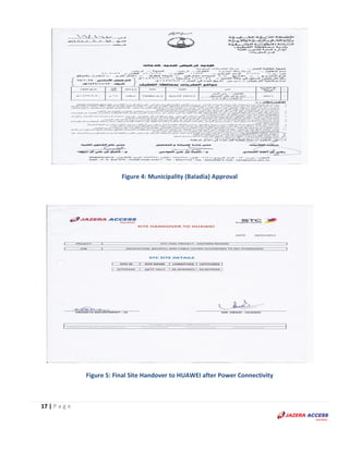
Figure 4: Municipality (Baladia) Approval
Figure 5: Final Site Handover to HUAWEI after Power Connectivity
18 | P a g e
Each VDSL Site requires above mentioned circle of implementation to have power through SEC.
Including to above its not possible to give productivity without excellent Project Management Skills, and
above project show that JA in not only a well established professional CONSULTANTS as well as excellent
Project Managers.
19 | P a g e
SEC (Saudi Electricity Company) GIS PROJECT
As experts in capture, analysis and management of data gathering for utility services we are one of the best
resourced LIDAR aerial mapping and satellite remote sensing, GPS technology companies in Kingdom and offer the
full spectrum of GIS services to such department. JAZERA ACCESS-JA technical department have a detailed
knowledge of such techniques and methodologies and the surveying applications required to support them
especially with electricity network.
We have had ongoing project in Saudi’s Central Region for Saudi Electricity Company having its primary goal of Data
Capturing, Analyzing and Implementing electrical distribution network from LV (110/220) to HV (132/380KV) onto
system. This is project was first to be completed by any contractor throughout kingdom
Gathered Data:
The following is the dataset that was provided to the client on project completion.
 Distribution Cabinets(LV)
 Poles(LV, MV & tower)(13.8kv, 33kv&132kv)
 OH Lines (LV, MV Line) (13.8kv, 33kv&132kv)
 Substations (UG & OH)
 Consumers
Accuracy:
Accuracy is the most aspect of any GIS project, JAZERA ACCESS-JA never compromises on it, by means of latest RTK,
GPS and satellite imagery, accuracy of less than 0.5m was achieved.
Planning:
This project was not only survey but a GIS solution that can be utilized in future as well, so it was divided into
following segments.
 Project Blueprint (from system feasibility, analysis and design)
 System construction
 GIS Applications and packages.
 GIS Data Model & Database.
 Map Conversion/ Electrical Network Digitization.
 Data Collection.
 Training.
 Setup System Infrastructure Environment.
 Base Map, Satellite Imagery.
 Setup GIS Centers.
 Applications Maintenance and Upgrade.
 Maintenance and Technical Support.
20 | P a g e
Milestones:
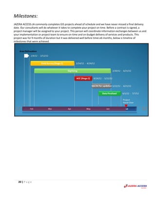
JAZERA ACCESS-JA commonly completes GIS projects ahead of schedule and we have never missed a final delivery
date. Our consultants will do whatever it takes to complete your project on time. Before a contract is signed, a
project manager will be assigned to your project. This person will coordinate information exchanges between us and
your implementation or project team to ensure on-time and on-budget delivery of services and products. This
project was for 9 months of duration but it was delivered well before timei.e6 months, below is timeline of
milestones that were achieved.
21 | P a g e
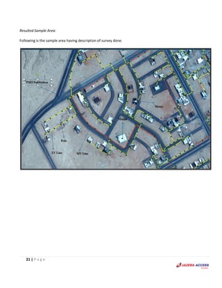
Resulted Sample Area:
Following is the sample area having description of survey done.
22 | P a g e
Results-Pictorial Panorama
Following are the pictures taken in the field by the surveyor during the survey done.
23 | P a g e
Results-Bird’s Eye Overview:
Following is the screenshot of the entire electrical LV (110,220,400) V network.
Results-Bird’s Eye Overview:
Following is the screenshot of the entire electrical MV (13.8, 33, and 132) KV network.
24 | P a g e
Results-Bird’s Eye Overview:
Following is the screenshot of the entire electrical network having Substations, Meters, Poles, Mini-Pillars,
Transformers, Switchgears, LVDB, LV & MV Lines.
GIS Training
Our GIS specialists offer a wide variety of training and education seminars and workshops that have been tailored
for local government and departmental use of GIS. Our training services include:
• ESRI Authorized GIS Training Classes
• Training on Trimble GPS hardware and software
• GIS in Local Government
• GIS: Keys to Success
Contact Us:
JAZERA ACCESS- GIS (Jazera Access Group)
Tel: 4709138 Fax: 4709139 Email: info@jazeraaccess.com
Kingdom Wide Network: RIYADH, DAMMAM, JEDDAH, ALKHARJ, MADINAH, QASSIM.
International Presence: PAKISTAN, BAHRAIN, UAE, USA.
25 | P a g e
Our Valued Clients:

More Related Content

Similar to JA SERVICES PROFILE

3DGIS company profile ENGLISH
3DGIS company profile ENGLISH3DGIS company profile ENGLISH
3DGIS company profile ENGLISH
3DGIS
 
Gis Mapping Companies In India
Gis Mapping Companies In IndiaGis Mapping Companies In India
Gis Mapping Companies In India
DSM Soft (P) Ltd
 
AABSyS Information Technology Private Limited - A GIS, CAD and Software Company
AABSyS Information Technology Private Limited - A GIS, CAD and Software CompanyAABSyS Information Technology Private Limited - A GIS, CAD and Software Company
AABSyS Information Technology Private Limited - A GIS, CAD and Software Company
webaabsys
 
RIQ LLC
RIQ LLCRIQ LLC
RIQ LLC
RIQ LLC
 
TechM GIS Utilities
TechM GIS UtilitiesTechM GIS Utilities
TechM GIS Utilities
TechM-GIS
 
Adavanced GIS Solution
Adavanced GIS SolutionAdavanced GIS Solution
Adavanced GIS Solution
Jenifer Robert
 
GIS as strategic management tool
GIS as strategic management toolGIS as strategic management tool
GIS as strategic management toolJonas Baile
 
ArcGIS
ArcGISArcGIS
ArcGIS
Esri
 
Gis application in civil engineering
Gis application in civil engineeringGis application in civil engineering
Gis application in civil engineering
Amal C Varghese
 
URISA GIS Management Institute® The GIS Capability Maturity Model and the GMI...
URISA GIS Management Institute® The GIS Capability Maturity Model and the GMI...URISA GIS Management Institute® The GIS Capability Maturity Model and the GMI...
URISA GIS Management Institute® The GIS Capability Maturity Model and the GMI...
Greg Babinski
 
TechM GIS Competency
TechM GIS CompetencyTechM GIS Competency
TechM GIS CompetencyTechM-GIS
 
Gisapplicationincivilengineering 140227110022-phpapp02
Gisapplicationincivilengineering 140227110022-phpapp02Gisapplicationincivilengineering 140227110022-phpapp02
Gisapplicationincivilengineering 140227110022-phpapp02
Antriksh Vatsyayana
 
Leveraging ArcGIS Platform & CityEngine for GIS based Master Plans
Leveraging ArcGIS Platform & CityEngine for GIS based Master PlansLeveraging ArcGIS Platform & CityEngine for GIS based Master Plans
Leveraging ArcGIS Platform & CityEngine for GIS based Master Plans
Esri India
 
Insights success the 10 fastest growing gis solution providers 18th dec 2017
Insights success the 10 fastest growing gis solution providers 18th dec 2017Insights success the 10 fastest growing gis solution providers 18th dec 2017
Insights success the 10 fastest growing gis solution providers 18th dec 2017
Insights success media and technology pvt ltd
 
ArcGIS
ArcGISArcGIS
ArcGIS
Esri
 
( G . i . s )
( G . i . s )( G . i . s )
( G . i . s )
Himanshu Chakravarti
 
MODERN trends of GIS
MODERN trends of GISMODERN trends of GIS
MODERN trends of GIS
VAISHALI JAIN
 
ArcGIS for Local Government
ArcGIS for Local GovernmentArcGIS for Local Government
ArcGIS for Local Government
Esri
 
TechM GIS Telecom
TechM GIS TelecomTechM GIS Telecom
TechM GIS TelecomTechM-GIS
 

Similar to JA SERVICES PROFILE (20)

3DGIS company profile ENGLISH
3DGIS company profile ENGLISH3DGIS company profile ENGLISH
3DGIS company profile ENGLISH
 
Gis Mapping Companies In India
Gis Mapping Companies In IndiaGis Mapping Companies In India
Gis Mapping Companies In India
 
AABSyS Information Technology Private Limited - A GIS, CAD and Software Company
AABSyS Information Technology Private Limited - A GIS, CAD and Software CompanyAABSyS Information Technology Private Limited - A GIS, CAD and Software Company
AABSyS Information Technology Private Limited - A GIS, CAD and Software Company
 
RIQ LLC
RIQ LLCRIQ LLC
RIQ LLC
 
TechM GIS Utilities
TechM GIS UtilitiesTechM GIS Utilities
TechM GIS Utilities
 
Adavanced GIS Solution
Adavanced GIS SolutionAdavanced GIS Solution
Adavanced GIS Solution
 
GIS as strategic management tool
GIS as strategic management toolGIS as strategic management tool
GIS as strategic management tool
 
ArcGIS
ArcGISArcGIS
ArcGIS
 
Gis application in civil engineering
Gis application in civil engineeringGis application in civil engineering
Gis application in civil engineering
 
URISA GIS Management Institute® The GIS Capability Maturity Model and the GMI...
URISA GIS Management Institute® The GIS Capability Maturity Model and the GMI...URISA GIS Management Institute® The GIS Capability Maturity Model and the GMI...
URISA GIS Management Institute® The GIS Capability Maturity Model and the GMI...
 
Situational awareness
Situational awarenessSituational awareness
Situational awareness
 
TechM GIS Competency
TechM GIS CompetencyTechM GIS Competency
TechM GIS Competency
 
Gisapplicationincivilengineering 140227110022-phpapp02
Gisapplicationincivilengineering 140227110022-phpapp02Gisapplicationincivilengineering 140227110022-phpapp02
Gisapplicationincivilengineering 140227110022-phpapp02
 
Leveraging ArcGIS Platform & CityEngine for GIS based Master Plans
Leveraging ArcGIS Platform & CityEngine for GIS based Master PlansLeveraging ArcGIS Platform & CityEngine for GIS based Master Plans
Leveraging ArcGIS Platform & CityEngine for GIS based Master Plans
 
Insights success the 10 fastest growing gis solution providers 18th dec 2017
Insights success the 10 fastest growing gis solution providers 18th dec 2017Insights success the 10 fastest growing gis solution providers 18th dec 2017
Insights success the 10 fastest growing gis solution providers 18th dec 2017
 
ArcGIS
ArcGISArcGIS
ArcGIS
 
( G . i . s )
( G . i . s )( G . i . s )
( G . i . s )
 
MODERN trends of GIS
MODERN trends of GISMODERN trends of GIS
MODERN trends of GIS
 
ArcGIS for Local Government
ArcGIS for Local GovernmentArcGIS for Local Government
ArcGIS for Local Government
 
TechM GIS Telecom
TechM GIS TelecomTechM GIS Telecom
TechM GIS Telecom
 

JA SERVICES PROFILE

  • 1. 1 | P a g e SERVICES PROFILE
  • 2. 2 | P a g e Table of Contents:  WHO WE ARE  WHAT WE OFFER  HSE POLICY  BUSINESS STRATEGY AND STEERING PLANNING  GIS STRATEGIC IMPLEMENTATION PLANNING  SERVICE WE PROVIDE  GIS IMPLEMENTATION SERVICES  DATA CREATION SERVICES  ADVANCED PUBLIC SAFETY GIS SOLUTION  ENTERPRISE GIS SOFTWARE FOR LOCAL GOVERNMENT  GEO DATA BASE DESIGN  GIS – IT INTEGRATION  APPLICATION DEVELOPMENT SOLUTIONS  GOLBAL POSITIONING SYSTEMS (GPS) FIELD INVENTORY  GIS & AM/FM  GPS MAPPING AND FIELD INVENTORY  JOINT USE INVENTORY  METER REPLACEMENT  DATA MAINTENANCE  PRINTING, PLOTTING, SCANNING AND TRUCK MAP IMAGING  DATABASE MODELING SETUP AND ADMINISTRATION  CUSTOM IMAGERY  PARCEL MAPPING  CUSTOM PROGRAMMING  TRAINING AND SUPPORT  GPS FIELD COLLECTION USING ARCPAD  GIS ARCHITECTURAL DESIGN AND IMPLEMENTATION  GIS DATA SUPPORT  GIS SUCCESS STORIES  STC (SAUDI TELECOM COMPANY) VDSL POWER PROJECT – WITH GIS SURVEY  SEC (SAUDI ELECTRIC COMPANY) GIS PROJECT  GIS TRAINING  CONTACT US  OUR VALUED CLIENTS
  • 3. 3 | P a g e Who we are Geographic Technologies Division (JAZERA ACCESS) is one of the country’s leading full-service local government GIS consulting companies with its main office located in Riyadh (KSA). JAZERA ACCESS has secured state, national, and international awards for products and services; built on its tradition of deploying the very best GIS solutions for local government, health, education and telecom sector. JAZERA ACCESS holds clients nationwide in Saudi Arabia and internationally present in Pakistan, Bahrain, UAE and USA. A corporate culture of quality, understanding, and commitment to our clients allows JAZERA ACCESS to continue to build an outstanding local government GIS portfolio. What We Offer • GIS COMPLETE SOLUTIONS • CONSULTANCY • NETWORK SURVEY & AUDIT • ASSET’S GEO TAGGING • UNDERGROUND UTILITY RESOURCES MANAGEMENT • FIXED NETWORK SOLUTIONS • GSM SOLUTIONS (INSTALLTION & COMMISSIONING ) • SYSTEM DESIGN & ENGINEERING • PROJECT MANAGEMENT • POWER SERVICES • OPERATION & MAINTENANCE A Leader in Strategic GIS Planning JAZERA ACCESS has a unique strategic planning methodology and ability to explore new ways for Clients to use GIS technology to improve efficiency, increase productivity, and save time, lives, and money. As the country’s leading experts in GIS strategic planning, JAZERA ACCESS delivers tailored solutions for towns, cities, and counties throughout the Saudi Arabia, and has outstanding references. Supporting this unique approach is the outstanding ability of the company to present GIS as an invaluable tool for Clients, and develop understandable step-by-step implementation guidelines for our clients. HSE Policy Since we deal with high power and work in open environment, we are committed to ensure the health and safety of our employees and field staff, and protecting the environment and the communities in which we operate. Meeting this commitment is a primary management objective as well as the individual and collective responsibility of all employees. We will achieve this through:  Complying with all relevant legal and other requirements;  Caring for the health and safety of our employees by providing adequate resources;  Creating a safe, healthy and environmental-friendly workplace by motivating all employees to take personal accountability.  Continuously improving the management system and practices
  • 4. 4 | P a g e Business Strategy and Steering Planning GIS Strategic Implementation Planning Geographic Technologies division (JAZERA ACCESS-JA-) has been helping local governments harness the power of geographic information systems though careful planning, intelligent implementation, and expert guidance at every phase of the process. JAZERA ACCESS® was founded specific call to help towns, cities, and counties of all sizes design, build, and implement cost effective GIS technology. Whether your organization is just beginning to explore GIS, or you have a mature, robust program, JAZERA ACCESS can take you to the next level. We’d like to be your partner to build a rich and prosperous future for your community and its citizens. The opportunities are limitless with effective GIS solutions, and JAZERA ACCESS can make those opportunities viable. GIS Services we provide While providing GIS Mapping Services, JAZERA ACCESS maintains a commitment to state-of-the-industry technology, research and innovation, implemented by highly experienced and qualified staff. Our team of engineers, geo-scientists, planners has developed GIS products and systems, integrated with GPS, GIS, and CAD. Our commitment and continuous effort for customer satisfaction have made JAZERA ACCESS a well-known and reliable GIS Data Conversions Service provider. GIS Implementation Services JAZERA ACCESS offers the very best cadre of experts in geospatial technologies. Success of GIS depends on many factors, including the creation and maintenance of accurate and reliable GIS data and databases. JAZERA ACCESS offers a complete range of geospatial services including: Our GIS Data Conversions Services include the following:  GIS Services in System Design and Architecture  GIS Services Management and Maintenance  Map Production and Analysis (specialized for GIS Mapping Agencies also)  Database Design and Development  GIS Applications Development (GIS Mapping and GIS Remote Sensing)  GIS Mapping User Training and Support  3D Modeling and Visualization for GIS Mapping Products and GIS Remote Sensing Products  Architectural CAD Drafting  Our Expertise  Experts in GIS for Utilities
  • 5. 5 | P a g e Towns, cities, and counties across the Saudi Arabia face the challenges of effective infrastructure management. Having timely and accurate infrastructure location data is critical to the success of any utility initiative. JAZERA ACCESS offers expert consulting services for the planning, design, and implementation of utility-based projects, and a full suite of enterprise software. JAZERA ACCESS’s GIS utility experts are working on many utility projects including: water systems, waste water, storm water, electric, telecom and gas. Data Creation Services JAZERA ACCESS works with organizations to convert paper and digital information into meaningful and reliable GIS database layers. Our services include digitizing, scanning, geo-referencing, GPS, data interpolation, and integration, and assuring data quality using sophisticated techniques. Advanced Public Safety GIS Solutions JAZERA ACCESS provides integrated GIS software for public safety agencies including: Police, Sheriff, Fire, and Emergency Medical Services. Experienced public safety and emergency response GIS experts plan design and implement a full range of practical, cost-effective GIS software solutions including: • Address Management • Mobile • AVL • Crimes • Dispatch • Emergency Notification • Routing • Fires Enterprise GIS Software for Local Government JAZERA ACCESS’s ultimate mission is to deliver affordable, easy-to-use geo-spatial integrated software solutions to every department within local government. JAZERA ACCESS’s enterprise products empower local government professionals with the ability to view, manage, analyze, distribute, and publish data. JAZERA ACCESS’s full suite of GIS software is distinguished by its user-friendliness, speed, and precision. JAZERA ACCESS’s new suite of software is focused on centrally managed and enterprise GIS solutions built on ESRI’s ArcGIS Server technology. JAZERA ACCESS’s software products serve every sector and include intranet, Internet, mobile, and touch screen solutions. A comprehensive and reliable implementation of GIS technology often includes the training and educating your organization, the design of a reliable and repeatable GIS database, and the building of meaningful digital data. It also includes Information Technology (IT) framework design and implementation, application design, and software integration and deployment. Geographic Technologies Division (JAZERA ACCESS-JA) professional services staff offer the following extensive Utilities’ services.
  • 6. 6 | P a g e JAZERA ACCESS has the capabilities to create GIS layers from many formats whether it is in database format or in hard copy format.
  • 7. 7 | P a g e Geo-Database Design We have proven expertise in the design and implementation of enterprise-wide GIS databases. True enterprise-wide databases are fully integrated with ESRI applications, external models, and system operations. A dedicated strategy for the design and deployment of a logical and physical database is being used for many organizations. Our database design strategies include: Enterprise GIS database design requires consideration of existing technology and multiple department requirements. GIS/IT Integration Integrating GIS software with existing technology is a priority for almost all organizations. We help agencies enhance their capabilities and maximize their current technology investments by integrating geo-spatial functionality with existing applications. We have spatially enabled hundreds of software systems including:
  • 8. 8 | P a g e Application Development Solutions Our professionals services include design, customization, and deployment of true enterprise-wide software solutions including desktop GIS, Web GIS, departmental intranet GIS, portable (hand-held) GIS tools and touch screen GIS technology. Global Positioning Systems (GPS) Field Inventory Our professionals use GPS technology to build accurate digital GIS data. JAZERA ACCESS helps our clients design and collects important infrastructure information; include street centerlines, and address points, signage, trees, sidewalks and facilities. When there is little or no source data, JAZERA ACCESS still has the capabilities to create the GIS layers that are needed. GIS & AM/FM GIS Landmark is experienced using multiple GIS platforms including AutoCAD, ArcInfo, Micro station and MapInfo. We specialize in utility mapping which consists of many different services including full system digitization, system modeling, land base creation, revisions, work order updates, circuit map creation, map conversion, raster to vector just to mention a few.
  • 9. 9 | P a g e GPS Mapping & Field Inventory GIS Landmark provides GPS mapping and field inventory for all utility types. We also provide training and data dictionary setup for our clients in the case they prefer to perform the field work themselves. Our staff is experienced with a number of global positioning system (GPS) brands and manual facilities inventory techniques. Using the ESRI mobile mapping software ArcPad and ArcPad Application Builder we are able to create user friendly forms for data collection to meet our individual client needs. Joint Use Inventory GIS Landmark provides detailed joint use inventory services for utility companies. We use the latest greatest technology along with skilled field technicians. In most cases we use the Ricoh GPS digital camera to record photos and location of each contact. We take these photos and load them into the GIS which give a very accurate location as well as a hyperlink in your GIS to the photo from the pole feature class. We collect all required attribute information about the joint-use contacts and can provide in many different formats compatible with all GIS software platforms. Meter Replacement GIS Landmark provides turnkey services to perform meter change-out programs that meet the requirements of our customers, as well as any regulatory agencies. We have worked with numerous clients to develop programs to achieve their service and budget goals. This effort is successfully accomplished with minimal disruption to the utility’s work environment and its valued customers. Data Maintenance Utilities often recognize that data maintenance is not a core competency within their operation and is, in fact, a distraction that keeps qualified people away from mission critical jobs. Data maintenance is like housework, it’s tedious, time consuming and is never finished. GIS Landmark provides a variety of data maintenance services for our clients. We have experience reading work orders for updating and understand most construction codes used by utility companies today. We will provide a GIS Landmark representative on-site if desired for these updates or they can be done remotely from our main office. Printing, Plotting, Scanning & Truck Map Creation At GIS Landmark we provide high quality B/W or color maps. We can plot many different sizes and on all types of paper (plain and glossy paper, vellum and transparent film) to fit your needs. We can plot large wall key maps for your main call center which comes in handy during outages. We also provide scanning services in B/W and color at a very high quality. We can produce bound truck maps at any size to use in the field and digital maps on CD for use on laptops.
  • 10. 10 | P a g e Database Modeling Setup & Administration The GIS data model is a complex definition of each point, line and polygon in the system and identifies the relationships between those objects. Data stored in the database describes information about these objects and how they are managed in the GIS. The database design must be compatible with existing data, meet the needs of the organization, support end-user applications, be dynamic and grow with the system, and avoid duplication and redundancy. Database tables and fields must be designed to effectively integrate with other in house systems such as billing, engineering and trouble call packages. The data structures must be compatible in order to communicate from one application to another. GIS Landmark provides database design and administration services for our clients. We are experienced in preparing databases to correspond with all applications. Custom Imagery Aerial and satellite imagery can improve your GIS system dramatically. It gives you the ability to automatically view subdivisions, rights of way, roads, waterways, buildings and facilities from your GIS system. Generally speaking imagery can be more current, less costly, and quicker to implement than traditional base mapping applications, particularly for larger service areas. Our image analysts are very experienced and can help you determine what is right for you. Parcel Mapping GIS Landmark can build an accurate land base using GPS Image BASE as the first step in the process. Then we can scan the clients existing paper parcel maps into the mapping system and geo-referenced to match the GPS Image BASE. If Scanning isn’t an option then we have the ability to draw the parcel maps to scale manually using coordinate geometry (COGO) techniques, while geo-referencing to the GPS Image BASE as we go. We also link the parcel polygon to a database record for easy look up and management. Custom Programming Once a GIS has been populated with data; end-users will need to access that data. Out-of-the-box GIS tools don’t always align with company operations and many utility company’s decide to develop specific programs (called applications) to assist staff updates and use the GIS data efficiently and effectively. In addition to company-specific applications, general GIS applications include tools designed to view and query the GIS data layers, generate predefined and ad hoc plots and reports, extract specific layers for project-specific work, and update, revise and maintain existing GIS data layers. GIS Landmark has the expertise to design and implement custom programs to fit our client’s needs for any of the GIS software applications. Training & Support We provide an array of training and consulting services for our clients. The training services provided by GIS Landmark depend on the specific needs of the individual client. We have a professional staff that has years of experience in many different aspects of GIS and utility mapping.
  • 11. 11 | P a g e GPS FIELD COLLECTION USING ARCPAD
  • 12. 12 | P a g e GIS Architectural Design and Implementation The backbone of any successful GIS is the IT infrastructure. Our team offers in-depth knowledge and understanding of systems integration, hardware, software, operating systems, networking, and peripheral devices. JAZERA ACCESS has experience in all phases of implementation and can assist from the initial Needs Assessment and budget creation to the complete implementation. A truly effective GIS integrates software with existing technology. GIS Data Support The GIS Data Support packages offer full, off-site support related to the management of GIS data. Our GIS professionals will spend a pre-determined number of days to help develop, update, and maintain your GIS data in order to meet your specific needs. We can assist with address point updates, street centerline editing, and even aerial photo conversion depending on what you need. Since GIS data is the foundation upon which your systems are built, accurately maintaining it is often very critical. Let JAZERA ACCESS do the work for you. Keep your data up-to- date with our GIS Data Support packages and feel good about staying on track.
  • 13. 13 | P a g e GIS Success Stories STC (Saudi Telecom Company) VDSL POWER PROJECT – WITH GIS SURVEY Jazera Access have already accomplished successfully the STC’s one of the huge projects named VDSL (Very High-speed Digital Subscriber’s Line) Power Project and provided complete power solution Kingdom wide for more than 3000 sites of STC. It’s a one of STC’s biggest projects and Jazera Access is completing it very successfully and already provided power through SEC (Saudi Electric Company) and connected more than 850 sites Kingdom Wide. Which is a proof that Jazera Access is capable of providing all kinds of power solution starting from Consultancy till Execution of the whole project as and where needed? One Source for your Power needs:
  • 14. 14 | P a g e Jazera Access started with STC as a Consultant of VDSL Project and during consultancy STC decided to give JA full charge of the project from Consultancy to Project Management. It was quite a big task and very difficult project in which many official sectors were involve and the productivity is needed on time. First of all its JA important part as an consultant was to provide the clear picture of all sites and available power source of SEC (Saudi Electric Company) and to match the needs of STC as well as to maintain and meet the SEC Standards for all 3000 sites. JA played very vital role to provide mutual acceptance through powerful expertise and JA was like bridge between STC and SEC and approved the necessary design from SEC for the final implementation of the STC Power Project. As we said before the project was quite difficult due to many of the official departments were involve and to reach the maximum productivity in shortest time it should be handled smartly.
  • 15. 15 | P a g e So, to make that possible it needs a circle of procedures to complete each site smoothly ending up with power, which are as follows: 1. GIS Survey (Site by Site and allocating the SEC source of power) 2. Approved Design (SEC and STC) 3. Site Map and Location (Indicating Source to have Approved Source Route of SEC) 4. SEC Approved Route 5. Baladia Approval (As per SEC Approved Route) 6. Civil Work Execution (Trenching/Excavation from SEC Source to Cabinet to lay the Cable as per SEC approved standards) 7. Baladia Approval Closing(After Completion of Civil Work) 8. VDSL Power Connectivity through SEC Engineers. 9. Site Handover to STC’s concerned to Assigned Offices. Figure 1: Initial Map (After GIS Survey)
  • 16. 16 | P a g e Figure 2: SEC Approved Route Figure 3: SEC Approved Route & Design
  • 17. 17 | P a g e Figure 4: Municipality (Baladia) Approval Figure 5: Final Site Handover to HUAWEI after Power Connectivity
  • 18. 18 | P a g e Each VDSL Site requires above mentioned circle of implementation to have power through SEC. Including to above its not possible to give productivity without excellent Project Management Skills, and above project show that JA in not only a well established professional CONSULTANTS as well as excellent Project Managers.
  • 19. 19 | P a g e SEC (Saudi Electricity Company) GIS PROJECT As experts in capture, analysis and management of data gathering for utility services we are one of the best resourced LIDAR aerial mapping and satellite remote sensing, GPS technology companies in Kingdom and offer the full spectrum of GIS services to such department. JAZERA ACCESS-JA technical department have a detailed knowledge of such techniques and methodologies and the surveying applications required to support them especially with electricity network. We have had ongoing project in Saudi’s Central Region for Saudi Electricity Company having its primary goal of Data Capturing, Analyzing and Implementing electrical distribution network from LV (110/220) to HV (132/380KV) onto system. This is project was first to be completed by any contractor throughout kingdom Gathered Data: The following is the dataset that was provided to the client on project completion.  Distribution Cabinets(LV)  Poles(LV, MV & tower)(13.8kv, 33kv&132kv)  OH Lines (LV, MV Line) (13.8kv, 33kv&132kv)  Substations (UG & OH)  Consumers Accuracy: Accuracy is the most aspect of any GIS project, JAZERA ACCESS-JA never compromises on it, by means of latest RTK, GPS and satellite imagery, accuracy of less than 0.5m was achieved. Planning: This project was not only survey but a GIS solution that can be utilized in future as well, so it was divided into following segments.  Project Blueprint (from system feasibility, analysis and design)  System construction  GIS Applications and packages.  GIS Data Model & Database.  Map Conversion/ Electrical Network Digitization.  Data Collection.  Training.  Setup System Infrastructure Environment.  Base Map, Satellite Imagery.  Setup GIS Centers.  Applications Maintenance and Upgrade.  Maintenance and Technical Support.
  • 20. 20 | P a g e Milestones: JAZERA ACCESS-JA commonly completes GIS projects ahead of schedule and we have never missed a final delivery date. Our consultants will do whatever it takes to complete your project on time. Before a contract is signed, a project manager will be assigned to your project. This person will coordinate information exchanges between us and your implementation or project team to ensure on-time and on-budget delivery of services and products. This project was for 9 months of duration but it was delivered well before timei.e6 months, below is timeline of milestones that were achieved.
  • 21. 21 | P a g e Resulted Sample Area: Following is the sample area having description of survey done.
  • 22. 22 | P a g e Results-Pictorial Panorama Following are the pictures taken in the field by the surveyor during the survey done.
  • 23. 23 | P a g e Results-Bird’s Eye Overview: Following is the screenshot of the entire electrical LV (110,220,400) V network. Results-Bird’s Eye Overview: Following is the screenshot of the entire electrical MV (13.8, 33, and 132) KV network.
  • 24. 24 | P a g e Results-Bird’s Eye Overview: Following is the screenshot of the entire electrical network having Substations, Meters, Poles, Mini-Pillars, Transformers, Switchgears, LVDB, LV & MV Lines. GIS Training Our GIS specialists offer a wide variety of training and education seminars and workshops that have been tailored for local government and departmental use of GIS. Our training services include: • ESRI Authorized GIS Training Classes • Training on Trimble GPS hardware and software • GIS in Local Government • GIS: Keys to Success Contact Us: JAZERA ACCESS- GIS (Jazera Access Group) Tel: 4709138 Fax: 4709139 Email: info@jazeraaccess.com Kingdom Wide Network: RIYADH, DAMMAM, JEDDAH, ALKHARJ, MADINAH, QASSIM. International Presence: PAKISTAN, BAHRAIN, UAE, USA.
  • 25. 25 | P a g e Our Valued Clients: