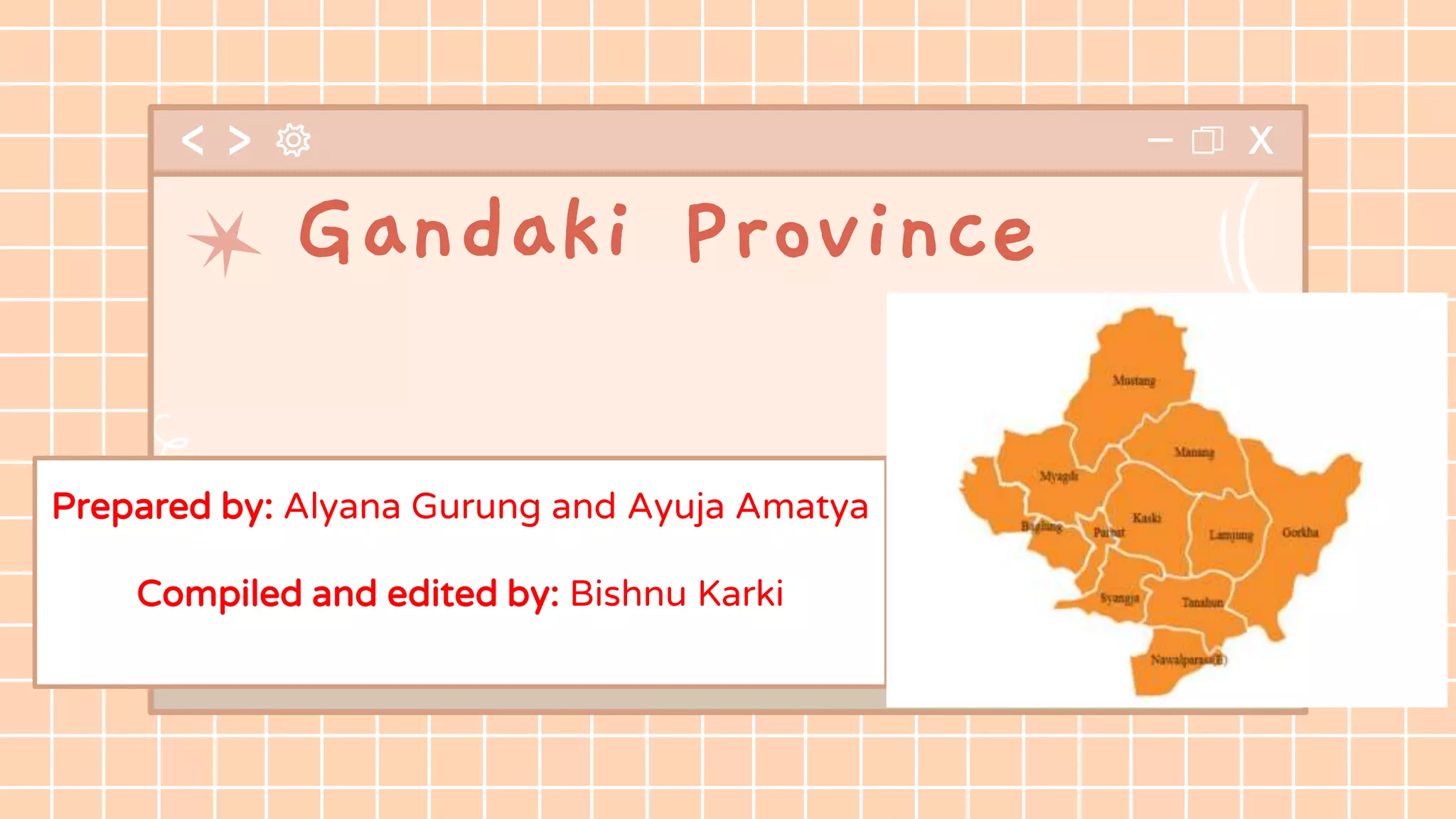
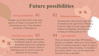
Gandaki Province is one of seven federal provinces established by Nepal's constitution. It has an area of 21,773 square kilometers and borders China and India. Pokhara is the capital city. The province has 11 districts and is known for tourism destinations like Fewa Lake and the Annapurna mountain range. It has a population of over 2 million people and Nepali, Magar, and Gurung are the main languages spoken. The province has potential for hydropower, mining of minerals, and connecting agricultural tourism to existing homestays in the region.
A Comparative Study of Tourism Industry in North-Eastern States of IndiaIOSR Journals
Despite of so many unique and natural beauties the North-eastern region of India is still place of least visited in India. Though the Government of India has been providing the financial assistance for development of tourist Infrastructure and promotion and marketing, the performances and development of the tourism in states is totally different. In this context, the present paper examines the tourism in North-eastern states of India. Major findings are the inflows of tourists are higher in Assam state and lower in Nagaland. Tourism sectors share in Gross State Domestic Product (GSDP) is high in Assam. As for the growth rate of tourists’ influx is concerned, the growth rate in Arunachal Pradesh is much higher with 55 percent compared to other states. Further, the Density of Tourist Population (DTP) and The Percapita Tourist arrival (PCT) is high in Sikkim with 101.57 and 1.19 respectively and lowest in Nagaland with 1.35 and 0.01. The major constraints of North-east tourism development and uneven performance among states are insufficient funds, lack of infrastructure, transportation, lack of alternatives means of transport, Marketing, boundary issues, terror effect and permit period. Steps should be taken to wipe-out the constraints for tourism development.
Manipur, as the name suggests, is a land of jewels. It is one of the “7 Sisters”of North-Eastern India. Its rich cultural heritage in martial arts, dance, theatre and sculpture has endured the test of time. Enjoy the charming beauty of Manipur with Theotherhome.com.
MGNREGA An Overview include all the basic information related to MGNREGA like its introduction, timeline of MGNREGA, It's salient features, Stakeholders associated with MGNREGA. Also include the performance and impact of MGNREGA on different issues like on Agriculture, on socio-economic of tribal people, on wage rates in agriculture, on women empowerment etc.
To get full detailed description about the topic contact me on alkesh.patel.2711@gmail.com
This was exclusively made by one journalist from CRI for Ministry of Commerce, PRC. During cultural exchange program it was presented and appreciated highly by the audience.
Mighty river systems of bangladesh and their impact on severe floods in bangl...Jahangir Alam
Mighty river systems of Bangladesh and their impact on severe floods in Banglades:
River Systems
Mighty River Systems of Bangladesh
Impact of River Systems in Flood
Flood in Bangladesh
Bangladesh is a country of rivers. The environment and livelihood of 160 million people is largely dependent on rivers and its resources. There are around 230 rivers which occupy about 7 percent of the total land area of Bangladesh.
The Ganges-Brahmaputra-Meghna (GBM) river basin is a transboundary river basin with a total area of just over 1.7 million km2, distributed between India (64 percent), China (18 percent), Nepal (9 percent), Bangladesh (7 percent) and Bhutan (3 percent).
The River Systems of
Bangladesh:
Major 3 river systems are:
The Brahmaputra-Jamuna
The Ganges-Padma and
The Meghna [surma-kusiara]
Total River number = 230
River comes from India = 54
River comes from Myanmar = 03
This notes about Introduction to Economic Geography. Which helped to Geography & Environmental Science department students.
In this note I will discourse about:
1) The concept of Economic Geography
2) Historical Vs Modern economic geography
Socio economic survey on siswan by charu jaiswalCharu Jaiswal
Socio economic survey on siswan of Siswan village in Kharar Tehsil of Rupnagar district in Punjab, India.I’m professional presentation maker . This document is for sale for, if required you can contact me on my gmail id bestpptmaker@gmail.com
LADAKH : TOURISM,CULTURE,LANGUAGE, CUSTOMS AND TRADITIONSSrinjoy Chatterjee
CONTENTS
1) Ladakh is a region administered by India as a union teritory , and
constituting a part of the larger Kashmir region, which has been the
subject of dispute between India, Pakistan , and China since 1947.It
is bordered by the Tibet Autonomous Region to the east, the Indian
state of Himachal Pradesh to the south, both the Indian-administered
union territory of Jammu and Kashmir and the Pakistan-
administered Gilgit-Baltistan to the west, and the southwest corner
of Xinjiang across the Karakoram Pass in the far north. It extends
from the Siachen Glacier in the Karakoram range to the north to the
main Great Himalaya to the south. The eastern end, consisting of
the uninhabited Aksai Chin plains, is claimed by the Indian
Government as part of Ladakh, and has been under Chinese control
since 1962. Until 2019, Ladakh was a region of the Indian-
administered state of Jammu and Kashmir . In August 2019,
the Parliament of India passed an act by which Ladakh became a
union territory on 31 October 2019.
2) Tourism is one of an economic contributor to the union territory
of Ladakh in Northern India. The union territory is part of the
broader disputed Kashmir region and is sandwiched between
the Karakoram mountain range to the north and the Himalayas to
the south and is situated at the height of 11,400 ft. Ladakh is
composed of the Leh and Kargil districts. The region contains
prominent Buddhist sites and has an ecotourism industry. As of
2020, tourism industry in Ladakh was worth ₹600
crore (US$84 million).
3) About life of people in Ladakh, they traditionally lead a nomadic rustic life and are
sincere and honest. About occupation of people in Ladakh, 90% of them depend on
agriculture based on the Indus River for their livelihood. Their main agricultural
products are barley, wheat, buckwheat, peas, rapeseed and beans. Apples and
apricots are grown in warmer regions of low altitude. Ladakh is well-known for its
rich culture . The Ladakh people are very hardworking and have productively used
the rich natural resources.
If you like the content plz give a like and share with your friends. For any querry contact me on LinkedIn (Link given in my profile).
Pokhara is a city of Kaski district in western development region of Nepal. It introduces main tourist hub in a central part of the country. The most popular touristic area presents outstanding views of snow-covered mountains and blue lakes to its visitors. It lies 202 kilometers west of Kathmandu. Pokhara is the second largest valley (466 sq. km.) filled with the diverse landscape, shimmering lakes, river, green hill, village, city, and lush vegetation.
We were assigned to come up with an original plan on destination development. We selected Bogalake, which is truly an amazing tourist destination in Bangladesh. We created strategically structured plan to enhance the attractiveness of the destination even more and attract more tourists while minding the sustainable development.
we are here to help you in the duration of your preparation
feel free to contact us for any query regarding your exam
contact us at : 9454721860, 0522-4241011
or log on to our website : www.iasnext.com
Feasibility study of project sant nagariSuraj Pande
Detail feasibility study of project SANT NAGARI is given in this feasibility study we came to know about project full specification, purpose of project, environment effect due to project, cost of project, employment from the project etc.
Disaster Prevention & Preparedness: Landslide in NepalKamlesh Kumar
This report is detailed study of the field survey conducted in Sindhupalchowk, Nepal. The basic objective of this report is to get a tough insight in the use of field techniques regarding disaster management. Geography deals with human interaction with nature. This phenomenon can be better understood through field studies. Geography, being a field science, a geographical enquiry always need to be supplemented through well planned field surveys. Field is an essential component of geographic enquire. It is a basic procedure to understand the earth as a home of humankind. It is carried out through observation, sketching, measurement, interviews, etc. Field work takes the children out of the class and enables them to better understand the subject by visiting the areas practically giving an insight into the social, cultural and economic lives of the people. This also adds up the advantage of visiting the grass root levels of the society and ameliorative comprehension of the GLOCAL lives. It also has instilled various research making techniques in the budding geographers and shaping their thinking perspectives. The field surveys facilitate the collection of local level information that is not available through secondary sources.
In this report, various methodologies have been employed such as mapping, digitization, measurement and interviewing (questionnaires designing), the collection and gathering of information at the local level by conducting primary surveys and later, tabulating and computing them is an important part of the field survey.
Furthermore, the field study report has been prepared in concise form alongside with maps and diagrams for giving visual impressions. Moreover, it contains all the details of the procedures followed, methods, tools and techniques employed and the modern technology of navigation, satellite connections, GIS software have been very helpful in the pre-field drills.
Welcome to TechSoup New Member Orientation and Q&A (May 2024).pdfTechSoup
In this webinar you will learn how your organization can access TechSoup's wide variety of product discount and donation programs. From hardware to software, we'll give you a tour of the tools available to help your nonprofit with productivity, collaboration, financial management, donor tracking, security, and more.
We all have good and bad thoughts from time to time and situation to situation. We are bombarded daily with spiraling thoughts(both negative and positive) creating all-consuming feel , making us difficult to manage with associated suffering. Good thoughts are like our Mob Signal (Positive thought) amidst noise(negative thought) in the atmosphere. Negative thoughts like noise outweigh positive thoughts. These thoughts often create unwanted confusion, trouble, stress and frustration in our mind as well as chaos in our physical world. Negative thoughts are also known as “distorted thinking”.
The Indian economy is classified into different sectors to simplify the analysis and understanding of economic activities. For Class 10, it's essential to grasp the sectors of the Indian economy, understand their characteristics, and recognize their importance. This guide will provide detailed notes on the Sectors of the Indian Economy Class 10, using specific long-tail keywords to enhance comprehension.
For more information, visit-www.vavaclasses.com
Students, digital devices and success - Andreas Schleicher - 27 May 2024..pptxEduSkills OECD
Andreas Schleicher presents at the OECD webinar ‘Digital devices in schools: detrimental distraction or secret to success?’ on 27 May 2024. The presentation was based on findings from PISA 2022 results and the webinar helped launch the PISA in Focus ‘Managing screen time: How to protect and equip students against distraction’ https://www.oecd-ilibrary.org/education/managing-screen-time_7c225af4-en and the OECD Education Policy Perspective ‘Students, digital devices and success’ can be found here - https://oe.cd/il/5yV
Palestine last event orientationfvgnh .pptxRaedMohamed3
An EFL lesson about the current events in Palestine. It is intended to be for intermediate students who wish to increase their listening skills through a short lesson in power point.
Unit 8 - Information and Communication Technology (Paper I).pdfThiyagu K
This slides describes the basic concepts of ICT, basics of Email, Emerging Technology and Digital Initiatives in Education. This presentations aligns with the UGC Paper I syllabus.
The Roman Empire A Historical Colossus.pdfkaushalkr1407
The Roman Empire, a vast and enduring power, stands as one of history's most remarkable civilizations, leaving an indelible imprint on the world. It emerged from the Roman Republic, transitioning into an imperial powerhouse under the leadership of Augustus Caesar in 27 BCE. This transformation marked the beginning of an era defined by unprecedented territorial expansion, architectural marvels, and profound cultural influence.
The empire's roots lie in the city of Rome, founded, according to legend, by Romulus in 753 BCE. Over centuries, Rome evolved from a small settlement to a formidable republic, characterized by a complex political system with elected officials and checks on power. However, internal strife, class conflicts, and military ambitions paved the way for the end of the Republic. Julius Caesar’s dictatorship and subsequent assassination in 44 BCE created a power vacuum, leading to a civil war. Octavian, later Augustus, emerged victorious, heralding the Roman Empire’s birth.
Under Augustus, the empire experienced the Pax Romana, a 200-year period of relative peace and stability. Augustus reformed the military, established efficient administrative systems, and initiated grand construction projects. The empire's borders expanded, encompassing territories from Britain to Egypt and from Spain to the Euphrates. Roman legions, renowned for their discipline and engineering prowess, secured and maintained these vast territories, building roads, fortifications, and cities that facilitated control and integration.
The Roman Empire’s society was hierarchical, with a rigid class system. At the top were the patricians, wealthy elites who held significant political power. Below them were the plebeians, free citizens with limited political influence, and the vast numbers of slaves who formed the backbone of the economy. The family unit was central, governed by the paterfamilias, the male head who held absolute authority.
Culturally, the Romans were eclectic, absorbing and adapting elements from the civilizations they encountered, particularly the Greeks. Roman art, literature, and philosophy reflected this synthesis, creating a rich cultural tapestry. Latin, the Roman language, became the lingua franca of the Western world, influencing numerous modern languages.
Roman architecture and engineering achievements were monumental. They perfected the arch, vault, and dome, constructing enduring structures like the Colosseum, Pantheon, and aqueducts. These engineering marvels not only showcased Roman ingenuity but also served practical purposes, from public entertainment to water supply.
Chapter 3 - Islamic Banking Products and Services.pptx
Gandaki
1. Prepared by: Alyana Gurung and Ayuja Amatya
Compiled and edited by: Bishnu Karki
Gandaki Province
2. Introduction
Gandaki Province is one of the seven federal provinces established by the current
constitution of Nepal which was promulgated on 3rd Ashwin, 2072 BS. The province has an
area of 21,773 km2 which is about 14.66% of the total area of Nepal. In terms of terrain, the
province is spread over the Himalayan region (26.8%), Hilly region (67.2%) and Terai region
(6%) of Nepal. Pokhara is the province’s capital city. It borders the Tibet Autonomous
Region of China to the north, Bagmati Province to the east, Karnali Province to the west and
Lumbini Province and Bihar of India to the south. Among the 7 provinces in Nepal, province
4 is one of the most promising provinces and more importantly, a renowned place for tourist
destination for the people of Nepal as well as abroad. Pokhara, the province 4 headquarter, is
world famous tourist place due to existence of Fewa Lake, Begnas Lake and opportunity to
see the Annapurna, Machhapuchhre and Dhaulagiri Himalayan Range. Also, this province is
important from religious point of view too, where the world famous Muktinath Chhetra lies.
Similarly, the province is observed to be economically viable since it can contribute in rural
livelihood through promotion of tourism, Hydropower Projects and production of agricultural
products.
5. GOVERNMENT AND ADMINISTRATION
The Governor acts as the head of the province while
the Chief Minister is the head of the provincial
government. The Chief Judge of the Pokhara High
Court is the head of the judiciary. The present
Governor, Chief Minister and Chief Judge are Sita
Poudel, Prithvi Subba Gurung and Purushottam
Bhandari. The province has 60 provincial assembly
constituencies and 18 federal House of
Representatives constituencies.
6. According to the 2011 Nepal census, there
are total 88 languages spoken in Gandaki
Pradesh. Nepali, Magar, Tharu, Gurung,
Darai, Ghale, Thakali, etc are the main
languages which is spoken by communities
in Gandaki Pradesh. Nepali, Magar and
Gurung are the three most spoken languages
in this province.
DEMOGRAPHICS AND LANGUAGE
The province has a population of 2,403,016
which is just about 9.06% of the total population
of Nepal. The sex ratio is 89 males for 100
females, with a total of 948,028 males and
1,144,124 females recorded in 2011. The urban
population of the region is 60.5% and the rural
population is 39.5% of the whole population.
7. Status
11% population is
below the poverty
line and literacy
rate is 77%. Kaski
ranks first in the
HDI and Gorkha
last. Gandaki has
37% of the forest
area and has
conserved majority
of it.
Drinking water
and electricity
On the cabinet led by Prithvi
Subba Gurung on Feb. 6,
2018, the government
announced they shall provide
drinking water and electricity
to all 578,000 households in 2
years. But, only 50% of water
supply has been completed.
Tourism
In 2019, Gandaki set out a plan
to boost domestic and
mainstream tourism by training
people, encouraging local
people, promoting homestays,
etc. They discussed alternative
trekking routes for some
mountains and to use cable
cars to Annapurna, Dhaulagi,
Manaslu base camps in the
future.
8. Gandaki covers about 40% of the total
glaciers of Nepal. It accounts for 55%
of hydropower now. It has abundant
possibility of Hydropower.
Scientists have discovered a huge cache
of uranium in the upper belt of Mustang.
It has the oldest iron and copper mines
(Parbat and Baglung). Researches are
working on finding gold as well.
Plans of making a triangle connection
between Pokhara, Saurah, and Lumbini.
The international airport to be completed
will increase tourists directly. Kaski to
Musstang route for tourist can be the
backbone for the tourism.
There are already more than 300 homestay
facilities in Gandaki, which serve local organic
food if it is being connected to Agro-Tourism it
will be another shine of tourism. As Gandaki is
the tourism capital, more income and benefit
from agriculture is possible.
Energy production
Tourism and routes
Minerals/resources
Agro-tourism
Future possibilities
01 02
03 04
9. CREDITS: This presentation template was created by Slidesgo,
including icons by Flaticon, infographics & images by Freepik
THANK YOU!