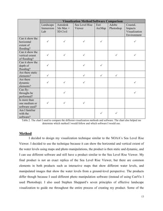
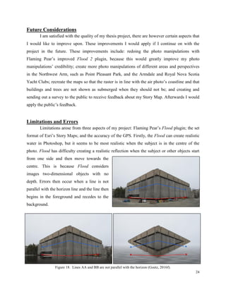
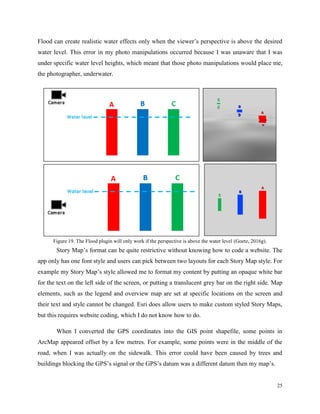
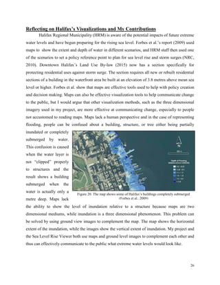
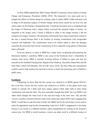
This document summarizes Florian Goetz's thesis project which involved visualizing future extreme water levels in Halifax's Northwest Arm in 2100. Goetz researched various visualization methods and chose to create photorealistic visualizations using photos he took of the Northwest Arm area. He manipulated the photos using software to simulate different water level scenarios resulting from sea level rise and storms. Goetz presented the manipulated photos in an interactive story map to effectively communicate the potential impacts of coastal flooding to viewers. The project aimed to test an innovative visualization method for sea level rise impacts that had not yet been used in Halifax.
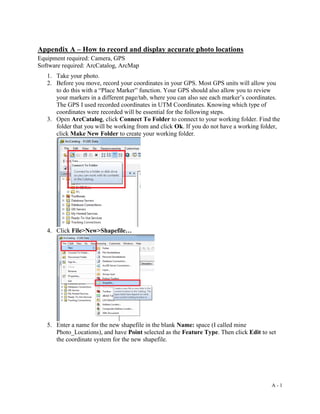
![32
Forbes, D.L., Manson, G.K., Charles, J., Thompson, K.R., & Taylor, R.B. (2009). Halifax
Harbour extreme water levels in the context of climate change: Scenarios for a 100-year
planning horizon. Retrieved from
http://www.halifax.ca/regionalplanning/documents/of6346final.pdf
Global Change. (2014). Changes in hurricanes. Retrieved from
http://nca2014.globalchange.gov/report/our-changing-climate/changes-hurricanes
Halifax Regional Municipality. (2010). HRM climate SMART community action guide to climate
change and emergency preparedness. Retrieved from https://www.halifax.ca/energy-
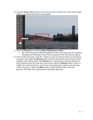
environment/environment/documents/ClimateSmartGuide_Final_PressRes.pdf
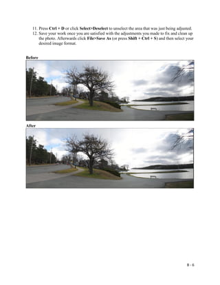
Halifax Regional Municipality. (2015). Land use by-law downtown Halifax. Retrieved from
http://www.halifax.ca/planning/documents/downtownhalifax_lub.pdf
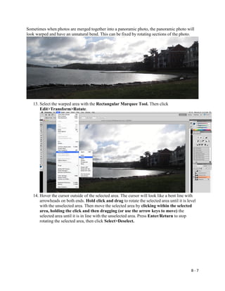
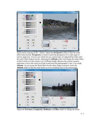
Hindrichs, H. (2015). A methodology for visualizing the vulnerability of buildings to sea level
rise on the Halifax Waterfront. Retrieved from Dalhousie University’s School of
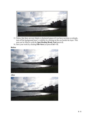
Planning’s Thesis Collection.
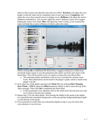
Intergovernmental Panel on Climate Change. (2015). Climate change 2014 synthesis report.
Retrieved from http://www.ipcc.ch/report/ar5/syr/
Jaffer, S. (2014, March 3). Meet CLIVE: an environmental fortune teller. The Peak. Retrieved
from http://www.the-peak.ca/2014/03/meet-clive-an-environmental-fortune-teller/
Maher, P., Rapaport, E., & Manuel, P. (2012). Visualising sea-level rise. Retrieved from
http://atlanticadaptation.ca/sites/discoveryspace.upei.ca.acasa/files/Visualising%20sea%2
0level%20rise_0.pdf
McBride, M. (2016, February 1). Re: New submission to: ContacUs [Email]. See appendix F.
National Oceanic and Atmospheric Administration. (2015). About NOAA. Retrieved from
http://www.noaa.gov/about-noaa.html
National Oceanic and Atmospheric Administration. (2016). CanVis distance calculations.
Retrieved from
https://coast.noaa.gov/digitalcoast/_/pdf/Height_and_Horizon_Calculations_in_CanVis.p
df
National Oceanic and Atmospheric Administration. (2015). Sea level rise and coastal flooding
impacts. Retrieved from https://coast.noaa.gov/slr/](https://image.slidesharecdn.com/15d99f13-137c-4a7e-9adc-fd4a7d0943c3-160408152157/85/Florian-Final-Thesis-Report-40-320.jpg)
![34
Thaler, A.D. (2013). #DrownYourTown: Exploring sea level rise through real-time, interactive,
GIS modeling. Retrieved from http://www.southernfriedscience.com/drownyourtown-
exploring-sea-level-rise-through-real-time-interactive-gis-modeling/
Zhang, K., Chen, S., Singh, P., Saleem, K., & Zhao, N. (2006). A 3D visualization system for
hurricane storm-surge flooding. Computer Graphics and Applications, IEEE, 26(1), 18-
25. doi: 10.1109/MCG.2006.4
Images Used
Cover Photo
Goetz, F. (2015a). Northwest Arm from Horseshoe Island [Photo]. Photo taken November 29,
2015.
Figure 1
2014 MIT CC: Channel 2. (2014). The world according to CLIVE (coastal impact visualization
emvironment [Youtube video]. Retrieved from UPEI
https://www.youtube.com/watch?v=XiagWbIvI8k
Figure 2
Arvidson, A.R. (2013, December). A Canadian researcher helps communities foretell what
climate change will look like. Landscape Architecture Magazine [Article image].
Retrieved from http://visualizingclimatechange.ca/in-the-media/landscape-architecture-
magazine-see-the-change/
Figure 3
Goetz, F. (2016a). Proximity to Northwest Arm [ArcGIS map]. Created March 20, 2016. Data
provided by Dalhousie GIS Centre.
Figure 4
Forbes, D.L., Manson, G.K., Charles, J., Thompson, K.R., & Taylor, R.B. (2009). Halifax
Harbour extreme water levels in the context of climate change: Scenarios for a 100-year
planning horizon [Report image]. Retrieved from
http://www.halifax.ca/regionalplanning/documents/of6346final.pdf
Figure 5
UPEI. (2014). CLIVE – Coastal impact visualization environment [Youtube video]. Retrieved
from https://www.youtube.com/watch?v=XiagWbIvI8k
Figure 6
National Hurricane Center & National Oceanic and Atmospheric Administration. (2006).
Tropical wind speed probabilities [Map]. Retrieved from
http://www.nhc.noaa.gov/pdf/NHC_WAF_Advances_Challenges_200904.pdf
Figure 7
Zhang, K., Chen, S., Singh, P., Saleem, K., & Zhao, N. (2006). A 3D visualization system for
hurricane storm-surge flooding [Report image]. Computer Graphics and Applications,
IEEE, 26(1), 18-25. doi: 10.1109/MCG.2006.4](https://image.slidesharecdn.com/15d99f13-137c-4a7e-9adc-fd4a7d0943c3-160408152157/85/Florian-Final-Thesis-Report-42-320.jpg)
![35
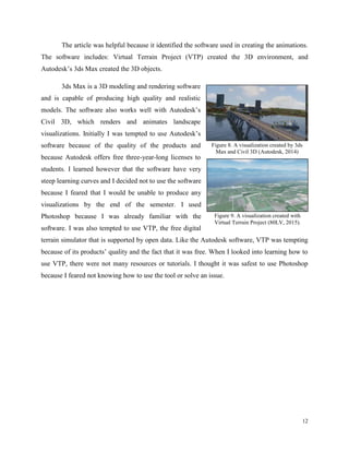
Figure 8
Autodesk 3ds Max Learning Channel. (2014). Using 3ds Max with Civil 3D – Part 24 –
Animating Cameras [Youtube video]. Retrieved from
https://www.youtube.com/watch?v=uHLYSNbFK60&list=PLnKw1txyYzRli2ZElR-
w9BcH8K8ltgntd&index=24
Figure 9
80LV. (2015). Virtual Terrain: Flight over Switzerland [Youtube video]. Retrieved from
https://www.youtube.com/watch?v=qm9zdozDfLU
Figure 10
Goetz, F. (2015b). Identified susceptible locations [ArcGIS map]. Created on November 20,
2015. Data provided by Halifax Open Data.
Figure 11
Goetz, F. (2016b). The difference in water levels during different site visits [Microsoft Word
graphic]. Created March 29, 2016.
Figure 12
Goetz, F. (2016c). Friend with metre stick [Photo]. Photo taken February 13, 2016.
Figure 13
Google Earth, & Goetz, F. (2015c). Google Earth ground-level view vs real view [Google Earth
and photo]. Photo taken December 12, 2015.
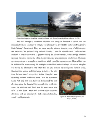
Figure 14
ArcGlobe, & Goetz, F. (2015d). ArcGlobe ground-level view vs real view [ArcGlobe and photo].
Data provided by Halifax Open Data, Photo taken December 12, 2015.
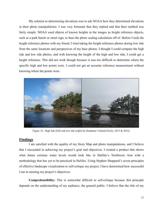
Figure 15
Goetz, F. (2016d). Altimeter and geodetic pin [Photo]. Photo taken January 27, 2016.
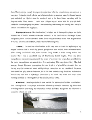
Figure 16
Goetz, F. (2015 & 2016). High and low tide by Deadman’s Island [Photo]. Photos taken
December 12, 2015 & February 11, 2016.
Figure 17
Goetz, F. (2016e). Horseshoe Island Park flooded [Photo manipulation]. Photo manipulation
created February 18, 2016.
Figure 18
Goetz, F. (2016f). Killam Library flooded [Photo and photo manipulation]. Photo taken March
29, 2016.
Figure 19 (2016g)
Goetz, F. (2016g). Importance of perspective [Word and Photoshop graphic]. Graphic created
April 5, 2016.
Figure 20
Forbes, D.L., Manson, G.K., Charles, J., Thompson, K.R., & Taylor, R.B. (2009). Halifax
Harbour extreme water levels in the context of climate change: Scenarios for a 100-year
planning horizon [Report image]. Retrieved from
http://www.halifax.ca/regionalplanning/documents/of6346final.pdf](https://image.slidesharecdn.com/15d99f13-137c-4a7e-9adc-fd4a7d0943c3-160408152157/85/Florian-Final-Thesis-Report-43-320.jpg)
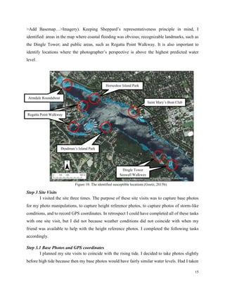
![36
Figure 21
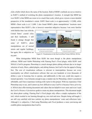
National Oceanic and Atmospheric Administration. (2015a). Sea level rise and coastal flooding
impacts [Website images]. Retrieved from https://coast.noaa.gov/slr/
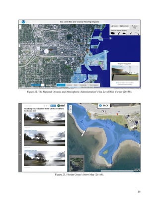
Figure 22
National Oceanic and Atmospheric Administration. (2015b). Sea level rise and coastal flooding
impacts [Website screenshot]. Retrieved from https://coast.noaa.gov/slr/
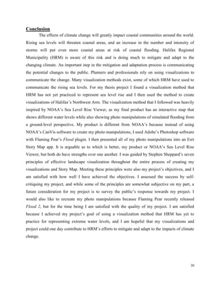
Figure 23
Goetz, F. (2016h). Visualizing future extreme water levels in Halifax’s Northwest Arm [Website
screenshot]. Retrieved from http://arcg.is/1W3bFcR](https://image.slidesharecdn.com/15d99f13-137c-4a7e-9adc-fd4a7d0943c3-160408152157/85/Florian-Final-Thesis-Report-44-320.jpg)