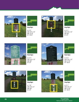
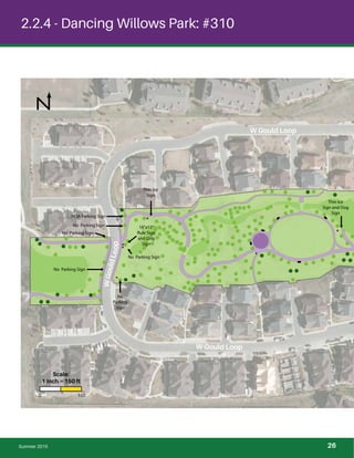
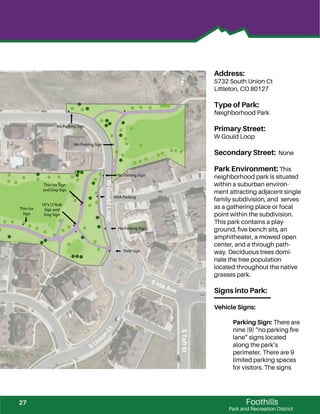
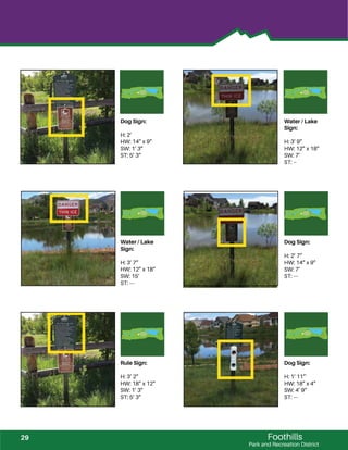
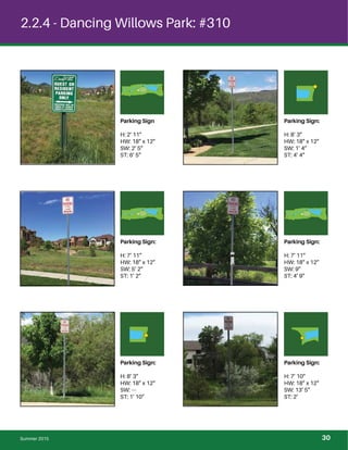
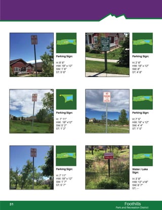
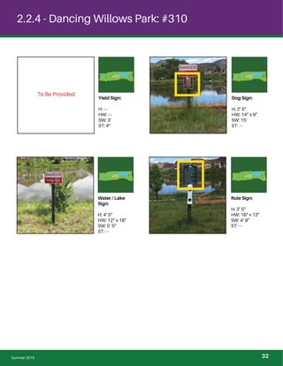
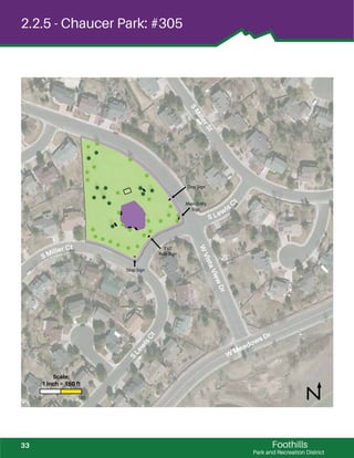
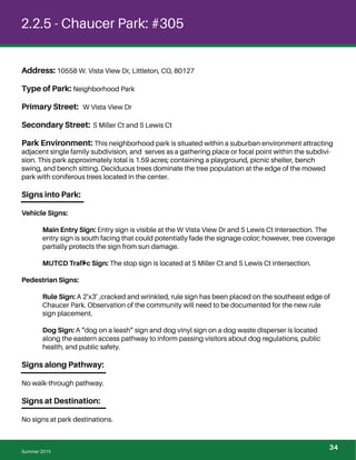
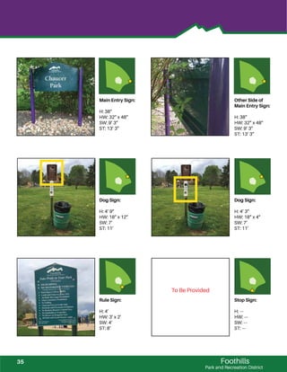
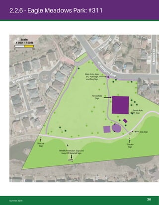
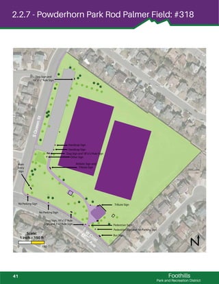
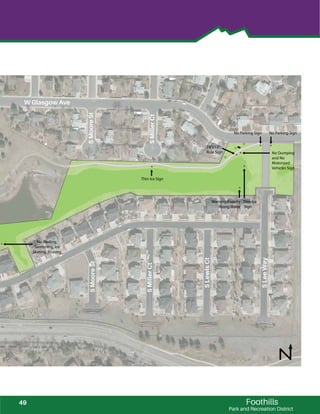
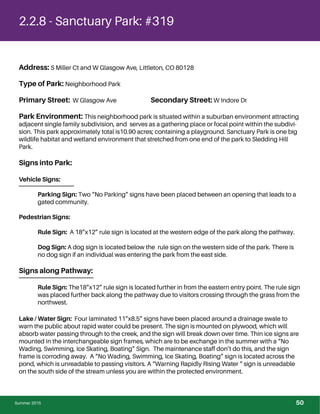
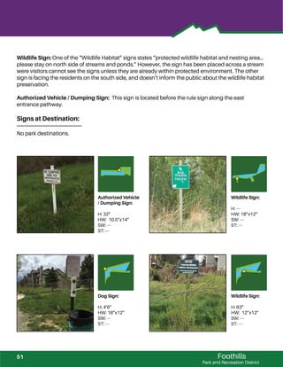
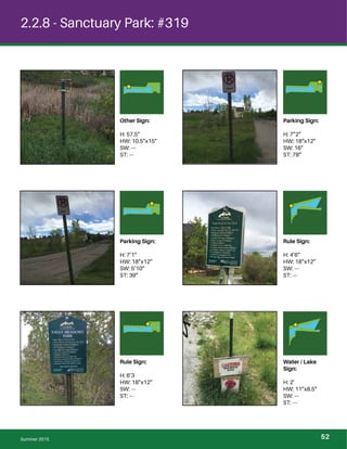
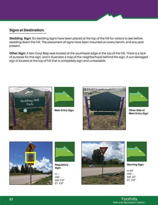
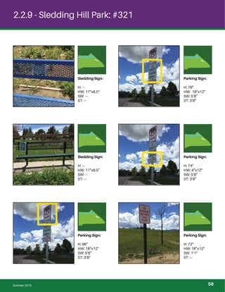
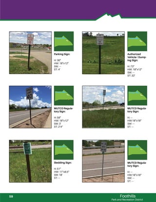
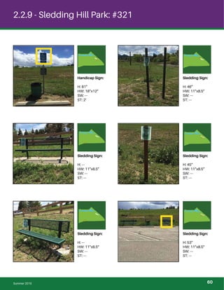
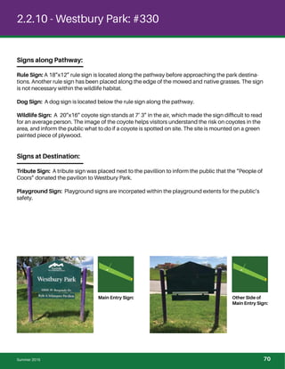
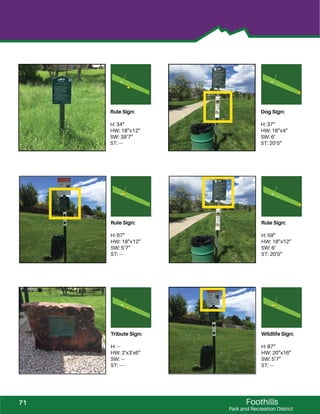
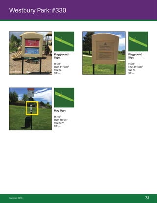
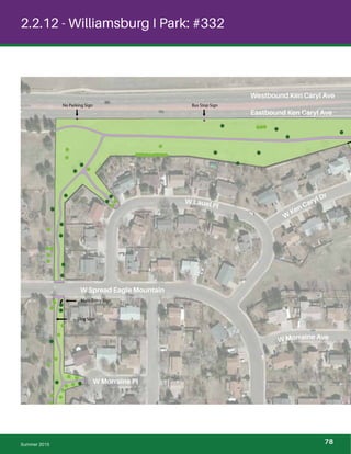
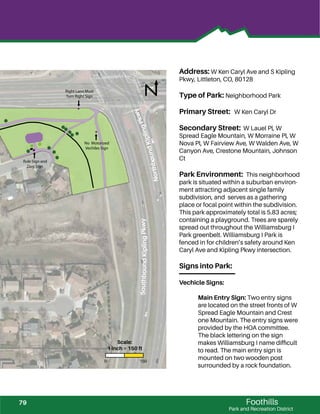
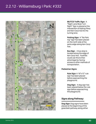
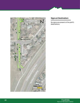
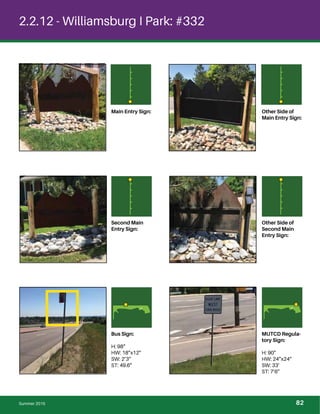
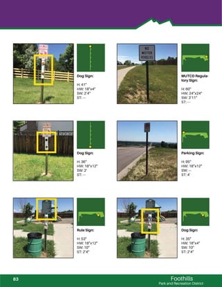
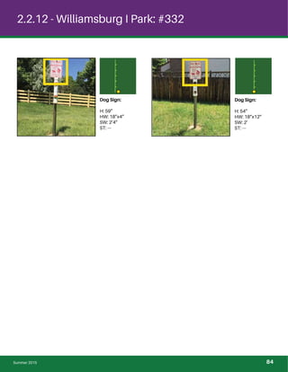
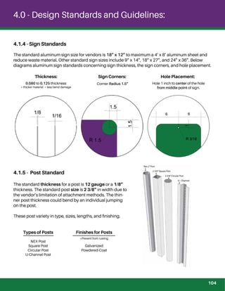
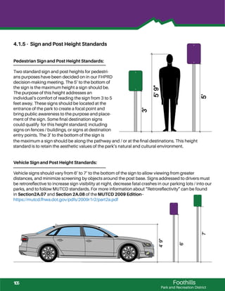
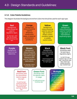
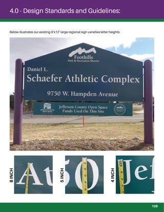
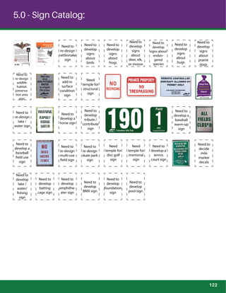
SlideShare a Scribd company logo
Foothills
Signage
&
Wayfinding
Manual
Park and Recreation District
1
Signage and Wayf
1.0 - Signage and Wayfinding Manual Introduction
1.1 - Purpose and Need........................................................................................................................................
1.2 - Funding.............................................................................................................................................................
1.3 - Manual Review...............................................................................................................................................
1.4 - Sign Maintenance.........................................................................................................................................
1.5 - Sign Plan Approval.......................................................................................................................................
1.6 - Procurement Process..................................................................................................................................
1.7 - Data Bases.......................................................................................................................................................
2.0 - Inventory of 2015 Signage:
2.1 - Existing Signage Inventory Description...............................................................................................
2.2 - Collection Process of Existing Signage................................................................................................
2.2.1 - Belleview Acre Park.........................................................................................
2.2.2 - Alper’s Farm Park..............................................................................................
2.2.3 - Bobby Hyatt Jr. Memorial Park....................................................................
2.2.4 - Dancing Willows Park.....................................................................................
2.2.5- Chaucer Park......................................................................................................
2.2.6 - Eagle Meadows Park......................................................................................
2.2.7 - Powderhorn Park / Rod Palmer Fields......................................................
2.2.8 - Sanctuary Park..................................................................................................
2.2.9 - Sledding Hill Park.............................................................................................
2.2.10 - Westbury Park.................................................................................................
2.2.11 - Sgt. Timothy M. Mossbrucker Memorial Park.....................................
2.2.12 - Williamsburg I Park.......................................................................................
3.0 - Regulations:
3.1 - Regulation Description...............................................................................................................................
3.1.1 - ADA Regulatory.................................................................................................
3.1.2 - FHWA - MUTCD Signs....................................................................................
3.1.3 - CDOT - State Highway Signs........................................................................
3.1.4 - Jeffco Signage Regulatory ..........................................................................
4.0 - Signage and Wayfinding Design Standards and Guidelines:
4.1 - Design Standards and Guidelines Description..................................................................................
4.1.1 - Jeffco Standards..............................................................................................
4.1.2 - ADA Standards..................................................................................................
4.1.3 - Fire Lane Sign Standards..............................................................................
4.1.4 - Sign Standards..................................................................................................
4.1.5 - Post Standards..................................................................................................
4.1.6 - Sign and Post Standards...............................................................................
7
8
8
8
8
8
8
10
11
14
17
22
26
33
36
41
48
54
68
73
78
86
86
86
86
86
102
102
103
103
104
104
105
inding Manual Context:
2
Foothills
Park and Recreation District
4.1.7 - Color Palette Guidelines...............................................................................
4.1.8 - Font Standards.................................................................................................
4.1.9 - Letter Height Guideline................................................................................
4.1.10 - Logos................................................................................................................
4.1.11 - ID Number........................................................................................................
4.1.12 - Sequence of Sign Placement...................................................................
5.0 Sign Catalog:
5.1 - Sign Catalog Description...........................................................................................................................
5.1.1 - Sign Catalog.......................................................................................................
6.0 Placement of Signage and Wayfinding:
6.1 - Next Phase Description...............................................................................................................................
6.2 - Overall FHPRD Map......................................................................................................................................
6.3 - Ward 1 Map.....................................................................................................................................................
Community Parks
6.3.1 - Sixth Avenue West Park and Pool...............................................................
6.3.2 - Weaver Hollow Park and Pool......................................................................
Neighborhood Parks
6.3.3 - Dewey Haberman Memorial Park...............................................................
6.3.4 - Estates Park.........................................................................................................
6.3.5 - Jim Hoida Memorial Park...............................................................................
6.3.6 - Trappers Glen Park...........................................................................................
6.3.7 - Weaver Creek Park...........................................................................................
6.4 - Ward 2 Map.....................................................................................................................................................
Regional Parks
6.4.1 - Robert F. Clement Park...................................................................................
6.4.2 - Fehringer Ranch Park .....................................................................................
6.4.3 - Daniel L. Schaefer Athletic Complex ........................................................
Community Parks
6.4.4 - Harriman Lake Park..........................................................................................
Neighborhood Parks
6.4.5 - Blue Heron Park................................................................................................
6.4.6 - Governor James B. Grant Park.....................................................................
6.4.7- Lakehurst Park....................................................................................................
6.4.8 - Lakehurst West Park........................................................................................
106
107
107
110
111
112
120
120
124
125
127
N/A
N/A
N/A
N/A
N/A
N/A
N/A
129
N/A
N/A
N/A
N/A
130
N/A
N/A
N/A
3
6.4.9 - Lilley Pad Park....................................................................................................
6.4.10 - Sunrise Creek Path ........................................................................................
6.4.11 - Westfield Park..................................................................................................
6.4.12 - Woodmar Square Park ................................................................................
6.5 - Ward 3 Map.....................................................................................................................................................
Regional Parks
6.5.1 - Robert A. Easton Regional Park...................................................................
Neighborhood Parks
301 - Alper’s Farm Park................................................................................................
302 - Belleview Acre Park............................................................................................
304 - Bobby Hyatt Jr. Memorial Park......................................................................
305 - Chaucer Park........................................................................................................
310 - Dancing Willows Park.......................................................................................
311 - Eagle Meadows Park.........................................................................................
318 - Powderhorn Park / Rod Palmer Fields.........................................................
319 - Sanctuary Park.....................................................................................................
321 - Sledding Hill Park................................................................................................
320 - Sgt. Timothy M. Mossbrucker Memorial Park...........................................
330 - Westbury Park......................................................................................................
332 - Williamsburg I Park.............................................................................................
6.5 - Ward 4 Map.....................................................................................................................................................
Community Parks
206 - Lilley Gulch Recreation Center Park and Pool.........................................
Neighborhood Parks
306 - Chief Colorow Park.............................................................................................
307 - Christensen Meadows Park............................................................................
325 - Valley View Park..................................................................................................
326 - Victory Park...........................................................................................................
327 - Wayside Meadows Park...................................................................................
329 - West Laurel Park..................................................................................................
6.6 - Ward 5 Map.....................................................................................................................................................
Community Parks
201 - Columbine Hills Park.........................................................................................
202 - Columbine Sports Park.....................................................................................
203 - Columbine West Park and Pool.....................................................................
N/A
N/A
N/A
N/A
133
N/A
N/A
N/A
N/A
N/A
N/A
N/A
N/A
N/A
N/A
N/A
N/A
N/A
135
N/A
N/A
N/A
N/A
N/A
N/A
N/A
137
N/A
N/A
N/A
4
Foothills
Park and Recreation District
204 - Deer Creek Park and Pool................................................................................
Neighborhood Parks
308 - Coronado Park.....................................................................................................
309 - Dakota Station Park............................................................................................
333 - Willow Creek Park...............................................................................................
334 - Wingate South Park...........................................................................................
7.0 Establishment Process:
7.1 - New Sign Approval.......................................................................................................................................
7.2 - Construction, Prices, and Maintenance................................................................................................
7.3 - Vendors.............................................................................................................................................................
N/A
N/A
N/A
N/A
N/A
139
141
143
5
1.0 - Signage and
Wayfinding
Manual
Introduction:
6
Foothills
Park and Recreation District
Foothills Park and Recreation District (FHPRD) is developing this manual to provide consistent
signage and wayfinding throughout our parks. Our signs will direct and inform the public on what is
allowed within the perimeters of Foothill’s Parks, give a positive impression of our parks, and enhance
our wayfinding methods. This manual will provide the reader or user: a sample inventory of existing
signs, future plans and placement of signs, regulations to follow, standards and guidelines created in
the decision-making phase, FHPRD sign catalog, and the establishment process.
1.1 - Purpose and Need
The purpose of this Manual is to provide FHPRD a way to track new and replaced signs for warranty
purposes and to understand a sign’s life span, develop signage standards and guidelines, develop a
sign catalog to maintain consistent signs throughout our parks, and develop solutions for cost effec-
tiveness, maintenance purposes, and maintain aesthetic values. This manual will guide the reader or
user through the process of replacing and / or placing new signs; which includes purpose and place-
ment of each sign, approval process for signs, sign number in sign catalog, prices and vendor infor-
mation, and the installation process.
Other sign objectives are to:
1. Provide positive impressions of our parks to create neighborhood engagement
2. Educate visitors about regulations and safety concerns
3. Acknowledge visitors of their location and how to wayfind throughout our parks
4. Control park usage to create a safer, more enjoyable, environmentally friendly experience
The objective is to balance the aesthetic considerations of our parks to avoid “sign pollution.”
The Signage and Wayfinding Manual informs FHPRD of the existing signs, existing sign conditions,
identifies the needs of signs, and the need of wayfinding through our parks. FHPRD needs a struc-
tured Manual with an efficient method to achieve an effective process to establish new or replace
signs, and create methods of wayfinding throughout our Foothill’s Parks.
This manual :
1. Provides an sample inventory of our existing signs.
2. Establishes the issues for our existing signs.
3. Provides regulations, codes, and policies for signs.
4. Provides design standards and guidelines developed by FHPRD Maintenance and Planning
1.0 - Signage and Wayfinding Manual Introduction:
7
Team.
5. Provides a Sign Catalog approved by FHPRD Maintenance and Planning Team.
6. Describes the sequence of signs throughout our parks.
7. Identifies the types of signs in each sequential phase.
8. Identifies the purpose and placement of signs in each sequential phase.
9. Describes the installation process for signs.
10. Describes the maintenance needs.
1.2 - Funding
Fundings for signs will be issued and reviewed by FHPRD. Funding will be provided by the FHPRD,
grants, or the public who has issued a sign approval application through Jefferson County.
Section 3.0 and Section 7.0 provides the process of the sign approval approach.
1.3 - Manual Review
A periodic review of this manual should be performed by FHPRD.
1.4 - Sign Maintenance
FHPRD Maintenance Department will properly position, maintain, and update all new placements or
replacements of signs throughout our parks. This Manual will provide the maintenance staff the
ordering process, placement and mounting of the sign, type of sign, and the installation process.
1.5 - Sign Plan Approval
Any sign approvals must by approved by Jefferson County.
1.6 - Procurement Process
A variety of vendors will be used for Foothills Parks and Recreation signage.
1.7 - Data Bases
Any new or replacement of sign will be updated into FHPRD GIS data base after Section 6.0 for new
signage and wayfinding methods has been completed.
8
2.0 - Inventory of
2015 Signage:
9
2.0 - Inventory of 2015 Signage
2.1 - Existing Signage Inventory Description: This section of the manual describes the
collection process of existing signs, what information was found about our existing signs, and a
sample of existing signs in various parks. The collection process informs the reader or user who
collected the data, how data information was collected, and what data information was collected.
The research collected and information found helped develop and support the standards and guide-
lines of this manual “Design Standards and Guidelines Section.” The standards and guidelines will
increase the consistency of signs throughout our parks, and consistent sign and post layouts.
The following pages provide a sample of the existing signs at our parks, which includes:
- A Map of the Park illustrating:
- Roadways
- Pathways
- Destinations
- Placement of: trees, benches, trash cans, playgrounds, picnic shelters, multi-fields,
court yards, wetlands, creeks, and signs
- Type of: trees and signs
- Surrounding community: commercial buildings, residential houses, undeveloped
land, etc.
- The Address of the Park
- Type of Park
- Primary and Secondary Roadway Names
- The Parks Environment describe the surrounding community, the park’s acreage, the park’s
landscape, and types of destinations to visit at the park.
- Description of Sign Types and Placement in Each Sequential Phase: Research
shows the placement of signs are inconsistent, and sparely located throughout each park.
There are three phases that an individual would approach a sign at a specific moment
throughout the park. These types of sequential phase in this manual are:
Signs into Park - Signs located at the entry points of a park or the perimeter of the
park.
10
Foothills
Park and Recreation District
Signs along Pathway - These signs would be located along a walk-through path
ways through the park.
Signs at Destination - These signs would be placed at destination points, which
would be a place of interest.
- Photos demonstrating the existing sign conditions and locations.
- Diagram of sign location.
- Type of Sign at location
- Height of a Sign on a Post (H)
- Height and Width of Sign (HW)
- The Distance of a Sign to the Sidewalk (SW)
- The Distance of a Sign to the Street (ST)
The research collected was analyzed to inform our maintenance and planning staff that Foothill’s
Park and Recreation needs to address their signage and wayfinding methods.
2.2 - Collection Process of Existing Signage: The signage and wayfinding data collection
informs FHPRD of the pro and cons of our existing sign conditions. The existing signage gives us an
insight on what signs are achieving or failing in from our existing signage and wayfinding methods.
Our findings inform us of:
- FHPRD wayfinds through our signs.
- Inconsistent types of sign from park to park.
- Sign placement is inconsistent at entry point, along pathways, and at destinations.
- Lack of purpose in sign placement.
- Damage or unreadable signs.
- Inconsistent sign and post layout.
- Varying sign and post heights.
11
2.0 - Inventory of 2015 Signage
- Lacking aesthetic values in signage with the park’s scenery.
Below describes the details of the data collection process of signs for this manual’s existing inven-
tory. This research will help structure standards and designs for our signage and wayfinding meth-
ods.
Who:
FHPRD collected the existing conditions of signs within various park to complete this manual’s inven-
tory data. Updating this manual is recommend to inform FHPRD the latest version of our signs.
GPS Data Collection:
The location of signs were collected by a GPS, and then documented in FHPRD GIS database for
storage. GPS data collected informs us of a sign’s location, location of trees that might effect a sign
conditions, and identifies potential sign or wayfinding placements needs.
Measurement Data Collection:
Measurement documentation gives FHPRD the opportunity to compare and contrast signs from a
pedestrian and driver perspectives. The height of a sign effects ones experience before entering a
park and within the setting of the park. The placement of a sign makes the sign have a purpose for its
location to a pedestrian or driver.
Picture Data Collection:
Picture documentation informs FHPRD of the conditions of each sign and takes into consideration
the needs of our future signs. The condition of each sign informs us of why and how a sign came to
be. The conditions that are taken into consideration for our future sign includes:
- What is the sign’s foundation?
concrete structure, T-post
- What is the surrounding landscape of the foundation?
xeriscape, flower bed landscaped, grass landscaped
- What type of landscape maintenance does the sign need?
spray weed killer on xeriscaping
maintains flower bed
weed whack landscape around foundation
12
Foothills
Park and Recreation District
- How is the sign structurally built?
welded, screws, bolts
- How is the sign produced?
vinyl sticker, decal lettering, painted lettering
- What is the sign material?
steel, aluminum, wood, laminate paper
- What is the size and shape of the sign?
rectangle, square, diamond, house shape
- Is the sign reflective?
- What type is the sign?
- What is the purpose for sign?
- How visible is the sign?
tree coverage, distance for sidewalk or road, readability
- What type of weather damage does the sign have?
sunlight exposure, snow, rain impacts
- What is the life span of the sign?
13
!!!!!
!
!!!!
!!!
!
!
!
!
!!
!
!
! !! !!
! !
!
!
!
!
!
!
!
!
!
!
!
!
!
!
!
!
!
!
!
!
!
!
! !
!
!!
!
!
!
!
!
2.2.1 - Belleview Acres Park: #302
S Zinna Ct
W
Arlington
Pl
W
AqueductAve
Dog Sign
Pedestrian Sign
Main
Entry
Sign
Playground Sign
Summer 2015
0 150
Scale:
1 inch = 150 ft
14
!!
!!!!
!!!
Foothills
Park and Recreation District
Address: 5420 S Zinnia Ct, Littleton, CO 80127
Type of Park: Neighborhood Park
Primary Street: S Zinnia Ct
Secondary Street: S Xenophon Way
Park Environment: This neighborhood park is situated within a suburban environ-
ment attracting adjacent single family subdivision, and serves as a gathering place or
focal point within the subdivision. This park approximately total is 3.37 acres, contain-
ing a playground, a picnic shelter, a gazebo, and a walk-through pathway. Deciduous
trees are sparsely located throughout the mowed park, while coniferous trees dominate
the eastern access point.
Signs into Park:
Vechicle Signs:
Main Entry Sign: The main entry sign has been placed off the primary road
between two suburban houses. The southeast side is faded due to the sun-
damage, and S Xenophon Way lacks a main entry sign.
MUTCD Warning Sign: A “MUTCD pedestrian sign” is located along S Zinnia
Court to inform drivers about potential pedestrian activity.
Pedestrian Signs:
Rule Sign: A 12”x18” rule sign is placed at the eastern edge near S Xenophon
Way. The density of the trees and shrubs make the sign’s readability very difficult
The post is surrounded by shrubs limiting the access to the sign at a short
distance, while trees screen the visibility from a longer distance.
Signs along Pathway:
Dog Sign: A dog sticker sign is located on a dog waste dispense along the eastern side
of the walk-through pathway to information passing visitors about our dog regulations.
Signs at Destination:
Playground Sign: A “children sign” is located adjacent to the playground to engage
children with the play equipment.
SXenophonWay
18”x12”
Rule Sign
15
2.2.1 - Belleview Acres Park: #302
Dog Sign:
H: ---
HW: 18” X 4”
SW: ---
ST: ---
Main Entry Sign:
H: ---
HW: 6’ 6” x ---
SW: 5’
ST: 13’
Other Side of
Main Entry Sign:
H: ---
HW: 6’ 6” x ---
SW: 5’
ST: 13’
MUTCD
Warning Sign:
H: ---
HW: 18” X 18”
SW: 16’ 5”
ST: 10’
Playground
Sign:
H: 6”
HW: 3’ 4” X 3’
SW: ---
ST: ---
Rule Sign:
H: 4’ 5”
HW: 18” X12”
SW: 8’
ST: 31’
Summer 2015
16
! !
!
!
!
!
!
! !
!
!
!!
!
!
Foothills
Park and Recreation District
2.2.2 - Alpers Farm Park: #301
W Belmont Ave
SOakWay
SMooreSt
SOakSt
SOakWay
W
W
eaverDr
W Parkhill Dr
No Motorized
Vehicles Sign
No Motorized
Vehicles Sign
Main
Entry
Sign
Children Playing
Sign and No
Parking Between
Signs
18”x12”Rule
Sign and No
Motorized
Vehicles Sign
3’x 2’Rule Sign
and Dog Sign
0 150
Scale:
1 inch = 150 ft
17
2.2.2 - Alpers Farm Park: #301
Address: 6204 S Moore St, Littleton, CO 80123
Type of Park: Neighborhood Park
Primary Street: S Moore St / S Oak St
Secondary Street: W Belmont Ave
Park Environment: This neighborhood park is situated within a suburban environment attracting
adjacent single family subdivision, and serves as a gathering place or focal point within the subdivi-
sion. This park approximately total is 5 acres, containing a playground, two picnic shelters, and an
entrance pathway. Coniferous trees dominate the tree population located around the playground
space with native grasses covering the surrounding landscape.
Signs into Park:
Vehicle Signs:
Main Entry Sign: The double-sided main entry sign has been placed off the primary roadway,
and between the two access points of the park’s main destination.
Parking Sign: A “No Parking Between Signs <--” was present; however, the other directional
sign “No Parking Between Sign -->” failed to be present. Parking was unclear from a driver’s
perspective. Available parking is located on the north side of the park and on the opposite
side of the street to the west.
Authorized Vehicle Sign: Two “No Motorized Vehicles” have been placed on the north side of
the park and one to the south edge of the park. The signs are to help prevent damage to the
native grasses and restricts access to the neighbor’s backyards. “No motorized Vehicles”
restricts access to handicap individuals.
MUTCD Warning Sign: A “MUTCD Children Playing Sign” on the southern edge of Alpers
Farm park is placed for drivers to be aware of potential children playing.
Pedestrian Signs:
Rule Sign: On the southern edge of Alpers Farm park, a12“x18” unraveling vinyl rule sign has
been placed for pedestrians approaching from the southern neighborhoods. This informs
the public before entering the parks perimeter.
Dog Sign: Two unknown dogs sign are placed on the northern edge of the park.
Summer 2015 18
Foothills
Park and Recreation District
Signs along Pathway:
No signs are present from the entry point of park to the park’s destination.
Signs at Destination:
Rule Sign: As you proceed to the playground and picnic shelters, a 2’x3’ sun damaged rule sign is
present with large font that makes it easy to read. The sign informs the public of FHPRD rules for the
public‘s health and safety, and preserves damage to FHPRD grounds.
Dog Sign: A vinyl sign is present on a dog waste dispenser beneath the 2’ by 3‘ rule sign.
Main Entry Sign:
H: ---
HW: 6’ 8” x 6‘
SW: 6’
ST: 10’
Other Side of
Main Entry Sign:
H: ---
HW: 6’ 8” x 6‘
SW: 6’
ST: 10’
Dog Sign:
H: 3’ 8”`
HW: 18” x 4”
SW: 5”
ST: ---
Rule Sign:
H: 6‘ 8”
HW: 3’ x 2’
SW: 5”
ST: ----
19
2.2.2 - Alpers Farm Park: #301
Dog Sign:
H: ----
HW: 6” x 4”
SW: 3”
ST: 4’ 3”
Dog Sign:
H: ---
HW: 6” x 4”
SW: 24’ 4”
ST: 28’ 4”
MUTCD
Warning Sign:
H: 8’ 6”
HW: 18“ x 18”
SW: 5’
ST: 9’
Rule Sign:
H: 7’ 9”
HW: 18” x 12”
SW: 23’ 10”
ST: 27’ 10”
Authorized
Vehicle Sign:
H: 6’ 5”
HW: 18” x 12”
SW: 26’
ST: 30’
Authorized
Vehicle Sign:
H: ---
HW: 18” x 12”
SW: 24’ 4”
ST: 30’ 6”
Summer 2015 20
Foothills
Park and Recreation District
Parking Sign:
H: 7’
HW: 18” x 12”
SW: 5’
ST: 9’
Authorized
Vehicle Sign:
H: 6’ 9”
HW: 18” x 12“
SW: 23’ 10”
ST: 27’ 10”
21
! ! !
!
!
!
!
!
!
!
!
!
2.2.3 - Bobby Hyatt Jr. Memorial Park:
W Belmont Ave
W Prentice PlW Prentice Dr
SXenophonCt
18”x12”Rule Sign
and Dog Sign
Main Entry Sign
0 150
Scale:
1 inch = 150 ft
Summer 2015
22
!
!
!
! !
!
Foothills
Park and Recreation District
Address: 5273 S. Ward St, Littleton, CO, 80127
Type of Park: Neighborhood Park
Primary Street: S Ward St
Secondary Street: S Prentice Dr
Park Environment: This neighborhood park is situated
within a suburban environment attracting adjacent single
family subdivision, and serves as a gathering place or focal
point within the subdivision. This park approximately total is
6.70 acres, containing a swinging bench, two sitting
benches, and a walk-through pathway. Coniferous trees are
sparsely located throughout the park with deciduous trees
at the southern edge of the mowed / native grass park.
Signs into Park:
Vehicle Signs:
Main Entry Sign: The two main entry signs are set
back to far for driving viewers and the street front. S
Ward St main entry sign’s visibility is screened by a
wooden fence. W Prentice Dr main entry sign is
more effected by sun-damage.
Pedestrian Signs:
Rule Sign: Both 12”x18”rule sign are cracking due to
the weather conditions. The vinyl rule signs are
placed adjacent to the entrance pathways. When
approaching from the southwest neighborhoods,
the western entrance pathway lacks information
about the park’s regulations.
SWardSt
Main Entry Sign
18”x12”Rule Sign
and Dog Sign
23
2.2.3 - Bobby Hyatt Jr. Memorial Park:
Main Entry Sign:
H: ---
HW: 32” x 48”
SW: 5’
ST: 32’
Other Side of
Main Entry Sign:
H: 36”
HW: 32” x 48”
SW: 5’
ST: 32’
Second Main
Entry Sign:
H: 36”
HW: 32” x 48”
SW: 19’
ST: 37’
Other Side of
Main Entry Sign:
H: 36”
HW: 32” x 48”
SW: 19’
ST: 37’
Dog Sign: One “dog waste” sign is graffitied and a dog sticker sign is located on a dog waste
dispenser beneath a rule sign adjacent to W Prentice Dr. One “dog on leash” sign and a dog
sticker sign is located on a dog waste dispenser is beneath a rule sign adjacent to S Ward St.
Signs along Pathway:
No signs are present along the walk-through pathway.
Signs at Destination:
No park destinations.
Summer 2015
24
Foothills
Park and Recreation District
Rule Sign:
H: 4’ 7”
HW: 18” x 12”
SW: 30”
ST: 27’
Rule Sign:
H: 4’ 2”
HW: 18” x 12”
SW: 12’ 8”
ST: 18’ 8”
Dog Sign:
H: 1’ 9”
HW: 18” x 4“
SW: 30”
ST: 27’
Dog Sign:
H: 2’ 1”
HW: 18” x 4”
SW: 12’ 8”
ST: 18’ 8”
Dog Sign:
H: 3’ 2”
HW: 18” x 12”
SW: 12’ 8”
ST: 18’ 8”
Dog Sign:
H: 3’ 7”
HW: 18” x 12”
SW: 30”
ST: 27’
25
!
! !
!
!
! !
!
!
!
!
!
!
!
! ! !
!
!
!
!
!
!
!
!
!
!
!
!
!
!
! !
!
!
!
!
!
! !
!
!
! !
!
! !
!
!
!!
!
!
!
!
!!
!
!
!
!
!
! !
!
!!
!
!
!
!
!
!!!
!
!
!! !!!
!
!
!
!
!
!
!
!
! !
!
!
!
!!
!
!
!
!!
!
!
!
!
!
!
!
!
!
!
!
!
!
!
!
! !
!
!
!
!
!
!
!
!
!
!
!
!
! !
!
!
!
!
!
!
!
!
! !
!
!
!
!!
!
!
!
!
!
! !! !
!!
!
!
! ! ! !
!
!
! !
!
! !
!
!
!!
!
!
!
!
!!
!
!
!
!
!
! !
!
!!
!
!
!
!
! !
!
!
!!!
!!!
!
!
! ! !
!
!
!! !
!
!
!
!
! !
!
!
!
!!
!
!!
!
!
!
!
!
!
!
!
! !
!
!
!
!
!
!
!
!
!
!
!
!
! !
!
!!
!
!
!
! !
!
! !
!
!
!!
!
!
!
!
!!
!
!
!
!
!
! !
!
!!
!
!!!
!!!
!! !
!
!
!
! ! !
!
!!
!
! !
!
!
!
!
!
!
!
!
! !
!
!
!
!
!!
!
!
!
!
!
!!
!
!
!
!!
!
!
!
!
!
!
!
!
!
!
!
!
!
!
!
! !
!
!
!
!
!
!
!
!
!
!
!
!
! !
!
!
!
!
!
!
!
!
! !
!
!
!
!!
!
!
!
!
!
!!! !
!!
!
!
! ! ! !
!
!
! !
!
! !
!
!
!!
!
!
!
!
!!
!
!
!
!
!
! !
!
!!
!
!
!
!
!
!!!
!
!
!!
!!
!!
!!! !
!
!
!!!
!!!
!
!
! !
! ! !
! !
! !
!
!! !
!!
!
!
!
!
!
!
!
!
!
Summer 2015
2.2.4 - Dancing Willows Park: #310
W Gould Loop
W Gould Loop
WGouldLoop
No Parking Sign
HOA Parking Sign
No
Parking
Sign
No Parking Sign
Thin Ice
Sign
No Parking Sign
No Parking Sign
Thin Ice
Sign and Dog
Sign
18”x12”
Rule Sign
and Dog
Sign
Summer 2015
0 150
Scale:
1 inch = 150 ft
26
!!!
!
!
!
!!
!
!
!
!!
!
!
! ! !
! !
!!
!
!
!
!
!
!!
!
!
!
!
!
!
!
!!
!!!
!
!
!
!
!
!
!
!!
!
!
!
!
!
! ! !
!
! ! !
!
! !
!!
! !
!!!!!!
!
!
!
!
!!
!
!
!
!
!
!
!
!
!
!!
!
!!!
!
!
!
!
! ! !
! !
!
!
!
!
!
!
!
!
!
!
!
!
!
!
!
!!!
!
!
!
!
!!
!
!
!
!!
!
!
!
!
! ! !
! !
!!
!
!
!
!
!
!
!
!
!!
!!!
!
!
!
!!
! !
!
!!
!
!
!
!
!
!
!!
!
!!!
!
!
!
!
! ! !
! !
!!
!
!
!
!
!
Foothills
Park and Recreation District
Address:
5732 South Union Ct
Littleton, CO 80127
Type of Park:
Neighborhood Park
Primary Street:
W Gould Loop
Secondary Street: None
Park Environment: This
neighborhood park is situated
within a suburban environ-
ment attracting adjacent single
family subdivision, and serves
as a gathering place or focal
point within the subdivision.
This park contains a play-
ground, five bench sits, an
amphitheater, a mowed open
center, and a through path-
way. Deciduous trees domi-
nate the tree population
located throughout the native
grasses park.
Signs into Park:
Vehicle Signs:
Parking Sign: There are
nine (9) “no parking fire
lane” signs located
along the park’s
perimeter. There are 9
limited parking spaces
for visitors. The signs
WGouldLoop
S Unio
n
Ct
S Ida Ave
STaftSt
Thin Ice
Sign
No Parking Sign
Yield Sign
18”x12 Rule
Sign and
Dog Sign
Thin Ice Sign
and Dog Sign
HOA Parking
No Parking Sign
No Parking Sign
No Parking Sign
27
2.2.4 - Dancing Willows Park: #310
adjacent to the parking spaces state “dancing willow guest or resident parking only,” which is
confusing because it is a public park. Dancing Willows HOA maintains these signs, and a
discussion should be put into place about their layout and purpose of their signs.
MUTCD Traffic Sign: A yield sign is located at the southeast edge of the park adjacent
to the round-about.
Pedestrian Signs:
Rule Sign: Two 18”x12” rule signs are adjacent to the primary pedestrian pathway. A
rule sign is placed at the western entry for visitors approaching from Mossbrucker Park or the
two parking spaces. The eastern rule sign is placed at the focal point off the primary and
secondary access pathways. Both signs are cracking making the sign difficult to read.
Dog Sign: One 9”x14” dog on leash sign is located at the western entry beneath a rule sign.
Signs along Pathway:
Dog Sign: Two dog signs are located around the edge of Dancing Willows Lake. One dog sticker
sign is located on a dog waste dispenser beneath a rule sign on the east side of the park.
Warning Sign: Four 18”x12” warning signs have been placed around the edge of Dancing Willows
Lake about thin ice; however, these signs warn visitors and don not reinforce the regulations.
Signs at Destination:
No signs at park destinations.
Summer 2015 28
Foothills
Park and Recreation District
Dog Sign:
H: 2’
HW: 14” x 9”
SW: 1’ 3”
ST: 5’ 3”
Water / Lake
Sign:
H: 3’ 9”
HW: 12” x 18”
SW: 7’
ST: --
Water / Lake
Sign:
H: 3’ 7”
HW: 12” x 18”
SW: 15’
ST: ---
Dog Sign:
H: 2’ 7”
HW: 14” x 9”
SW: 7’
ST: ---
Rule Sign:
H: 3’ 2”
HW: 18” x 12”
SW: 1’ 3”
ST: 5’ 3”
Dog Sign:
H: 1’ 11”`
HW: 18” x 4”
SW: 4’ 9”
ST: ---
29
2.2.4 - Dancing Willows Park: #310
Parking Sign
H: 2’ 11”
HW: 18” x 12”
SW: 2’ 5”
ST: 6’ 5”
Parking Sign:
H: 8’ 3”
HW: 18” x 12”
SW: 1’ 4”
ST: 4’ 4”
Parking Sign:
H: 7’ 11”
HW: 18” x 12”
SW: 5’ 2”
ST: 1’ 2”
Parking Sign:
H: 7’ 11”
HW: 18” x 12”
SW: 9”
ST: 4’ 9”
Parking Sign:
H: 8’ 3”
HW: 18” x 12”
SW: ---
ST: 1’ 10”
Parking Sign:
H: 7’ 10”
HW: 18” x 12”
SW: 13’ 5”
ST: 2’
Summer 2015 30
Foothills
Park and Recreation District
Parking Sign:
H: 8’ 6”
HW: 18” x 12”
SW: 1‘ 6”
ST: 5’ 6”
Parking Sign:
H: 2’ 8”
HW: 18” x 12”
SW: 8”
ST: 4’ 8”
Parking Sign:
H: 7’ 11”
HW: 18” x12”
SW: 5‘ 2“
ST: 1’ 2”
Parking Sign:
H: 7’ 5”
HW: 18” x 12”
SW: 4’ 4”
ST: 1’ 5”
Parking Sign:
H: 7’ 11”
HW: 18” x 12”
SW: 1’ 7”
ST: 5’ 7”
Water / Lake
Sign:
H: 3’ 8”
HW: 12” x18”
SW: 6’ 7”
ST: ---
31
To Be Provided
2.2.4 - Dancing Willows Park: #310
Water / Lake
Sign:
H: 4’ 5”
HW: 12” x 18”
SW: 5’ 5”
ST: ---
Rule Sign:
H: 3’ 5”
HW: 18” x 12”
SW: 4’ 9”
ST: ---
Yield Sign:
H: ---
HW: ---
SW: 3’
ST: 4”
Dog Sign:
H: 2’ 5”
HW: 14” x 9”
SW: 15’
ST: ---
Summer 2015 32
!
!
!
!
!
!
! !
!
!
!
!
!
!
!
!
!
!
!
!
!
!
!
!
!
!
!
!
!
!!
!
!
!!!
!
!
!
!!
Foothills
Park and Recreation District
2.2.5 - Chaucer Park: #305
WVistaViewDrS Lewis C
t
S Miller Ct
S
Lew
isCt
SM
illerSt
W
Meadows Dr
Stop Sign
3’x2’
Rule Sign
Main Entry
Sign
Dog Sign
0 150
Scale:
1 inch = 150 ft
33
2.2.5 - Chaucer Park: #305
Address: 10558 W. Vista View Dr, Littleton, CO, 80127
Type of Park: Neighborhood Park
Primary Street: W Vista View Dr
Secondary Street: S Miller Ct and S Lewis Ct
Park Environment: This neighborhood park is situated within a suburban environment attracting
adjacent single family subdivision, and serves as a gathering place or focal point within the subdivi-
sion. This park approximately total is 1.59 acres; containing a playground, picnic shelter, bench
swing, and bench sitting. Deciduous trees dominate the tree population at the edge of the mowed
park with coniferous trees located in the center.
Signs into Park:
Vehicle Signs:
Main Entry Sign: Entry sign is visible at the W Vista View Dr and S Lewis Ct Intersection. The
entry sign is south facing that could potentially fade the signage color; however, tree coverage
partially protects the sign from sun damage.
MUTCD Traffic Sign: The stop sign is located at S Miller Ct and S Lewis Ct intersection.
Pedestrian Signs:
Rule Sign: A 2’x3’ ,cracked and wrinkled, rule sign has been placed on the southeast edge of
Chaucer Park. Observation of the community will need to be documented for the new rule
sign placement.
Dog Sign: A “dog on a leash” sign and dog vinyl sign on a dog waste disperser is located
along the eastern access pathway to inform passing visitors about dog regulations, public
health, and public safety.
Signs along Pathway:
No walk-through pathway.
Signs at Destination:
No signs at park destinations.
Summer 2015
34
Foothills
Park and Recreation District
Main Entry Sign:
H: 38”
HW: 32” x 48”
SW: 9’ 3”
ST: 13’ 3”
Other Side of
Main Entry Sign:
H: 38”
HW: 32” x 48”
SW: 9’ 3”
ST: 13’ 3”
Dog Sign:
H: 4’ 9”
HW: 18” x 12”
SW: 7’
ST: 11’
Dog Sign:
H: 4’ 3”
HW: 18” x 4”
SW: 7’
ST: 11’
Rule Sign:
H: 4’
HW: 3’ x 2’
SW: 4’
ST: 8’
Stop Sign:
H: ---
HW: ---
SW: ---
ST: ---
To Be Provided
35
!
!
!
!
!
!
!
!
!!
!
!
!
!!
!
!
!
!
!
!
!
! !
!
!!
!
!
!
!
!!
!
!
!
!
!
!
!
!
!
!
!
!
!
!
!
!
!
!
!
!
2.2.6 - Eagle Meadows Park: #311
W
Gl
asgow
Ave
SMooreCt
S Nelso
n
St
W Hinsdale Dr
Thin Ice
Sign
Thin Ice
Sign
Dog Sign
Wildlife Protection Sign and
Keep Off Waterfall Sign
Main Entry Sign,
3’x2’Rule Sign,
and Dog Sign
Tennis Rule
Sign
Tennis Rule
Sign
Summer 2015
0 150
Scale:
1 inch = 150 ft
36
!
Foothills
Park and Recreation District
Address: 10576 W Glasgow Ave, Littleton, CO, 80127
Type of Park: Neighborhood Park
Primary Street: W Glasgow Ave
Secondary Street: None
Park Environment: This neighborhood park is situated within a suburban
environment attracting adjacent single family subdivision, and serves as a gath-
ering place or focal point within the subdivision. This park approximately total is
10.45 acres; containing a playground, basketball court, tennis court, sand pit, a
gazebo, and an entrance pathway. Deciduous trees are sparsely located through
the mowed park, while wetlands are located on the southern part of the park that
FHPRD is trying to protect.
Signs into Park:
Vehicle Signs:
Main Entry Sign: Located off primary road. Views of main entry sign are
blocked for both passing vehicles and pedestrians due to parked cars in
front of the sign.
Pedestrian Signs:
Rule Sign: Two 3’x2’ rule signs have been place behind the main entry
sign. Visitors approaching from the northwest or east would notice and be
informed about the park’s rules.
Dog Sign: Dog signs are located beneath the rule signs to inform the
public about the dog regulations before entering the park.
Signs along Pathway:
Dog Sign: A dog sign is located between the primary and secondary pathways,
which should only be placed at the entry points of the park.
Wildlife
Protection
Sign
37
2.2.6 - Eagle Meadows Park: #311
Main Entry Sign:
H: 3’
HW: 32” x ---
SW: ---
ST: ---
Other Side of
Main Entry Sign:
H: 3’
HW: 32” x ---
SW: ---
ST: ---
Rule Sign:
H: 4’ 7”
HW: 3’ x 2’
SW: ---
ST: ---
Rule Sign:
H: 4’ 7”
HW: 3’ x 2’
SW: ---
ST: ---
Warning Sign: Warning signs about thin ice are located along the edge of the wetland area.
Wildlife Sign: FHPRD has developed areas for wildlife habitat and nesting preservation on the south-
ern side of the park.
Signs at Destination:
Rule Sign: Tennis rule sign have been placed on the fence outside the entry point into the tennis
courtyard.
Summer 2015 38
Foothills
Park and Recreation District
Wildlife Sign:
H: 2’ 2”
HW: 12” x 18”
SW: ---
ST: ---
Wildlife Sign:
H: ---
HW: 12” x 18”
SW: ---
ST: ---
Water / Lake
Sign:
H: 5’ 1”
HW: 11” x 15”
SW: 41’
ST: ---
Tennis Sign:
H: ---
HW: ---
SW: ---
ST: ---
Water / Lake
Sign:
H: ---
HW: 11” x 15”
SW: ---
ST: ---
Dog Sign:
H: 2’ x11”
HW: 18” x 12”
SW: ---
ST: ---
39
2.2.6 - Eagle Meadows Park: #311
Water / Lake
Sign:
H: 2’ 2”
HW: 18” x 12”
SW: ---
ST: ---
Tennis Sign
H: ---
HW: ---
SW: ---
ST: ----
Dog Sign:
H: 2’ 11”
HW: 18” x 12”
SW: ---
ST: ---
Dog Sign:
H: 4’ 10”
HW: 18” x 12”
SW: 9’
ST: ---
To Be Provided
Summer 2015 40
!
!
!
!
! !
!
!
!!
!!
!
!
!!
!
! !
!
!
!
!
!
!!!
! ! !
!
!
!
!
!
!
!
!
!
!
!!
! !
!
!
!
!
!!
!
!
!
!
! !
!
!
!
!
!
!
!
! !
!
! !
!
!
!
!
!
!
!
!
!
!
!
!
!
!
!
!
Foothills
Park and Recreation District
2.2.7 - Powderhorn Park Rod Palmer Field: #318
Dog Sign and
18”x12”Rule Sign
Handicap Sign
Handicap Sign
Dog Sign and 18”x12 Rule Sign
Other Sign
Athletic Sign and
Tribute Sign
No Parking Sign
No Parking Sign
Dog Sign, 18”x12”Rule
Sign, and 3’x2’Rule Sign Pedestrian Sign
Pedestrian Sign and No Parking Sign
Bus Sign
Tribute Sign
Main
Entry
Sign
SQueenSt
W
Coal
M
ineAve0 150
Scale:
1 inch = 150 ft
41
2.2.7 - Powderhorn Park Rod Palmer Field: #318
Address: 11501 W. Coal Mine Ave, Littleton, CO 80127
Type of Park: Community Park
Primary Street: W Coal Mine Ave
Secondary Street: S Queen St
Park Environment: This community park is situated within an suburban environment attracting
visitors from the nearby subdivision and meeting community-based recreational needs. This park
approximately total is 10.05 acres; containing a playground, two picnic shelter, and two multi-use
fields. Deciduous trees dominate the tree population at the edge of the mowed park with coniferous
trees sparely scattered.
Signs into Park:
Vehicle Signs:
Main Entry Sign: Entry sign is visible at the intersection of S Queen St and W Coal Mine Ave.
The entry sign is southwest facing with sun-damaged paint. The main entry is larger than other
urban park main entry signs, and the purpose for its larger size is Powderhorn Park is a commu
nity park.
ADA Sign - Two handicap signs are located closest to the walk-through pathway entrance
and multi-use fields.
MUTCD Regulatory Sign - Three “No Parking” signs are located on the primary roadway due
to MUTCD purposes.
MUTCD Warning Sign - Pedestrian signs are located at the cross way of the primary roadway,
the playground entrances, and at the beginning of the walk-through pathway.
Bus Sign - A bus stop is located at the southeast corner of the park, which Foothills could use
to their advantage by bringing other visitors in our park by other methods of transportation.
Pedestrian Signs:
Rule and Dog Sign - Two 18”x12” rule sign with dog signs below have be placed at the
entrance of walk-through pathways. The placement of the 18”x12” rule sign and dog sign at
the northeast corner of the parking lot is odd. If there are already rule signs at the walk-through
pathway entrance, the placement of the 3’x2’ rule sign along the primary roadway is unneces-
Summer 2015 42
Foothills
Park and Recreation District
Main Entry Sign: Other Side of
Main Entry Sign:
Handicap Sign:
H: 6’11”
HW: 18”x12”
SW: ---
ST: 1’7”
Handicap Sign:
H: 6’10”
HW: 18”x12”
SW: ---
ST: 1’5”
Signs along Pathway:
Other Sign - There is a unused sign holder on the edge of a drained-up detention pond. The sign was
used to inform the public about thin ice and water regulatory.
Signs at Destination:
Contribute / Tribute Sign - A contribute sign on a rock is located between the walk-through path-
way and the multi-use fields. The sign informs visitors about the family and friends who promoted
and dedicated the fields at Powderhorn Park. Another tribute sign is located at the northwest corner
of the playground turf. The sign informs visitors where funds came from for the community play-
ground, and thanks the community and funders in making the build possible.
43
2.2.7 - Powderhorn Park Rod Palmer Field: #318
Dog Sign:
H: ---
HW: 14”x9“
SW: ---
ST: 1’6”
Dog Sign:
H: ---
HW: 14”x4”
SW: ---
ST: 1’6”
Dog Sign:
H: 2’ 10”
HW: 14”x4”
SW: 1’10”
ST: 5’10”
Bus Sign:
H: 7’7”
HW: 18”x12”
SW: ---
ST: ---
Summer 2015
Tribute Sign:
H: 4’6”
HW: 12”x18”
SW: ---
ST: ---
Contribute Sign:
H: 18”
HW: 18”x12”
Rock: 30”x34”
SW: 3’
ST: ---
44
Foothills
Park and Recreation District
Pedestrian Sign:
H: ---
HW: 18”x18”
SW: 11’8”
ST: 15”8”
Regulatory
Sign:
H: 10’6”
HW: 8”x30“
SW: 9’5”
ST: 13’5”
Other Sign:
H: 5’
HW: 10.5”x15”
SW: 15’
ST: 25’
Multi-field Sign:
H: 3’5”
HW: 20”x28”
SW: 3’
ST: ---
Other Side of
Athletic Sign:
H: 3’5”
HW: 20”x28”
SW: 3’
ST: ---
Rule Sign:
H: 5’1”
HW: 18”x12”
SW: ---
ST: 1’6”
45
2.2.7 Powderhorn Park Rod Palmer Field: #318
Parking Sign:
H: 6’6”
HW: 18”x12”
SW: ---
ST: ---
Parking Sign:
H: 6’6”
HW: 18”x12”
SW: 9’5”
ST: 13’5”
Rule Sign:
H: ---
HW: 3’x2’
SW: 18’8”
ST: 22’8”
Rule Sign:
H: 4’2”
HW: 18”x12”
SW: 1’10”
ST: 5’10”
Rule Sign:
H: 4’6”
HW: 18”x12”
SW: 4’3”
ST: 2’5”
Dog Sign:
H: ---
HW: 14”x9”
SW: 18’8”
ST: 22’8”
Summer 2015 46
Foothills
Park and Recreation District
Dog Sign:
H: 4’6”
HW: 14”x9”
SW: 4’3”
ST: 2’5”
Dog Sign:
H: 3’3”
HW: 14”x4”
SW: 4’3”
ST: 2’5”
Handicap Sign:
H: 6’3”
HW: 6”x12”
SW: ---
ST: 1’7”
Handicap Sign:
H: 6’2”
HW: 6”x12”
SW: ---
ST: 1’5”
Warning Sign:
H: ---
HW: --- x ---
SW: 11’8”
ST: 15”8”
Pedestrian Sign:
H: 8’
HW: 30”x30“
SW: 9’5”
ST: 13’5”
47
!
!
!
!
!
!
!!
!
!
!
!
!
!
!!!
!
!
!
2.2.8 - Sanctuary Park: #319
No Trespassing
Sign
Wildlife Habitat
Sign
Thin Ice Sign
Temporary Water
Warning Sign
18”x12: Rule
Sign and
Dog Sign Wildlife
Habitat
Sign
Eastbound Ken Caryl Ave
Westbound Ken Caryl Ave
W Indore Dr
W Hinsdale Dr
SOakCt
SOwensCt
SParfetCt
0 150
Scale:
1 inch = 150 ft
Summer 2015 48
!
!!
!
!
!
!
! !
!
!
!!
!
!
Foothills
Park and Recreation District
Thin Ice Sign
Warning Rapidly
Rising Water
No Parking SignNo Parking Sign
Thin Ice
Sign
No Dumping
and No
Motorized
Vehicles Sign
18”x12”
Rule Sign
No Wading,
Swimming, Ice
Skating, Boating
W Glasgow Ave
SMooreSt
SMillerCt
SMooreSt
SMillerCt
SLewisCt
SLeeWay
49
2.2.8 - Sanctuary Park: #319
Address: S Miller Ct and W Glasgow Ave, Littleton, CO 80128
Type of Park: Neighborhood Park
Primary Street: W Glasgow Ave Secondary Street: W Indore Dr
Park Environment: This neighborhood park is situated within a suburban environment attracting
adjacent single family subdivision, and serves as a gathering place or focal point within the subdivi-
sion. This park approximately total is10.90 acres; containing a playground. Sanctuary Park is one big
wildlife habitat and wetland environment that stretched from one end of the park to Sledding Hill
Park.
Signs into Park:
Vehicle Signs:
Parking Sign: Two “No Parking” signs have been placed between an opening that leads to a
gated community.
Pedestrian Signs:
Rule Sign: A 18”x12” rule sign is located at the western edge of the park along the pathway.
Dog Sign: A dog sign is located below the rule sign on the western side of the park. There is
no dog sign if an individual was entering the park from the east side.
Signs along Pathway:
Rule Sign: The18”x12” rule sign is located further in from the eastern entry point. The rule sign
was placed further back along the pathway due to visitors crossing through the grass from the
northwest.
Lake / Water Sign: Four laminated 11”x8.5” signs have been placed around a drainage swale to
warn the public about rapid water could be present. The sign is mounted on plywood, which will
absorb water passing through to the creek, and the sign will break down over time. Thin ice signs are
mounted in the interchangeable sign frames, which are to be exchange in the summer with a “No
Wading, Swimming, Ice Skating, Boating” Sign. The maintenance staff don’t do this, and the sign
frame is corroding away. A “No Wading, Swimming, Ice Skating, Boating” sign is located across the
pond, which is unreadable to passing visitors. A “Warning Rapidly Rising Water “ sign is unreadable
on the south side of the stream unless you are within the protected environment.
Summer 2015 50
Foothills
Park and Recreation District
Authorized Vehicle
/ Dumping Sign:
H: 32”
HW: 10.5”x14”
SW: ---
ST: ---
Wildlife Sign:
H: ---
HW: 18”x12”
SW: ---
ST: ---
Dog Sign:
H: 4’6”
HW: 18”x12”
SW: ---
ST: ---
Wildlife Sign:
H: 63”
HW: 12”x12”
SW: ---
ST: ---
Wildlife Sign: One of the “Wildlife Habitat” signs states “protected wildlife habitat and nesting area...
please stay on north side of streams and ponds.” However, the sign has been placed across a stream
were visitors cannot see the signs unless they are already within protected environment. The other
sign is facing the residents on the south side, and doesn’t inform the public about the wildlife habitat
preservation.
Authorized Vehicle / Dumping Sign: This sign is located before the rule sign along the east
entrance pathway.
Signs at Destination:
No park destinations.
51
2.2.8 - Sanctuary Park: #319
Other Sign:
H: 57.5”
HW: 10.5”x15”
SW: ---
ST: ---
Parking Sign:
H: 7”2”
HW: 18”x12”
SW: 16”
ST: 78”
Parking Sign:
H: 7’1”
HW: 18”x12”
SW: 5’10”
ST: 39”
Rule Sign:
H: 4’6”
HW: 18”x12”
SW: ---
ST: ---
Rule Sign:
H: 6’3
HW: 18”x12”
SW: ---
ST: ---
Water / Lake
Sign:
H: 2’
HW: 11”x8.5”
SW: ---
ST: ---
Summer 2015 52
Foothills
Park and Recreation District
Trespassing
Sign:
H: ---
HW: ---
SW: ---
ST: ---
Water / Lake
Sign:
H: 70”
HW: 10.5”x15”
SW: 16’
ST: ---
Water / Lake
Sign:
H: 61.5”
HW: 10.5”x15”
SW: ---
ST: ---
Water / Lake
Sign:
H: 2’10”
HW: 18”x12”
SW: ---
ST: ---
Water / Lake
Sign:
H: 2’6”
HW: 18”x12”
SW: ---
ST: ---
Water / Lake
Sign:
H: 2’
HW: 11”x8.5”
SW: ---
ST: ---
53
!
!
!!
!!
!!
!
!
!!!
!
!
!
!
!
!
!
!
! !
!
!
!
! !
!
2.2.9 - Sledding Hill Park: 321
No Motorized
Vehicles - No
Dumping Sign
Warning Turn Sign
and Speed Sign
No Parking Sign, 10 Minute Parking
Sign, and Tow Away Zone Sign
Tree City Sign
No Parking Sign
No Parking Sign
No Parking Sign
Sledding Hill Sign
Sledding Hill SignKen Carol Map Sign
Sledding Hill Sign
Sledding Hill Sign
Sledding Hill Sign
Other Sign and
Sledding Hill Sign
No Parking Sign
Warning Curve Sign, 30 mph
Sign, and Next 2000 Feet Sign
Sledding Hill Sign
Summer 2015
W Glasgow Ave
W Geddes Cir
Eastbound Ken
Westbound Ken
Southbound
0 150
Scale:
1 inch = 150 ft
54
!
!
!
!
!
!
!
!
!
!
!
!
!
!
!
!
!
!!
!
!
!
!
!
!
!
!
!
!
!
!
!
!
!
!
!
!
!
!
Foothills
Park and Recreation District
Address: S Kipling Pkwy
and W Ken Caryl Ave, Little-
ton, CO 80128
Type of Park:
Neighborhood Park
Primary Street:
S Kipling Pwky and
W Ken Caryl Ave
Secondary Street:
W Glasgow Ave
Park Environment: This
neighborhood park is situ-
ated within a suburban
environment attracting
adjacent single family
subdivision, and serves as a
gathering place or focal
point within the subdivision.
This park approximately
total is 30.40 acres;
containing a sledding hill.
The hill is covered with
native grasses and scat-
tered areas of prairie dog
habitats.
Signs into Park:
Vehicle Signs:
Main Entry Sign: The
damaged main entry
sign has been placed
off the primary road
way, and the
Right Lane Must Turn Right Sign
Stop Sign and Right Turn Only Sign
Speed Limit
40 Sign
Bus Stop Sign
Adopt-A-Highway
Sign, Vivian Court
Friends Sign, and
Litter Pick Up
Ahead Sign
Yield Sign
Right Lane Must Turn Right Sign
No Motor Vehicles
Sign and Bike
Route Sign
Right Lane Must
Turn Right Sign
No Parking
Beyond This
Point Sign
Main Entry Sign and
Sledding Hill Sign
No Parking
Beyond This
Point Sign
Contribute Sign
Handicap Sign, Van
Sign, and Rule Sign
Handicap Sign
and Sledding Sign
Sledding
Hill Sign
No Parking Beyond This Point Sign
Sledding Hill Sign
Caryl Ave
Caryl Ave
Northbound
Kipling
Pkw
y
Kipling
Pkw
y
55
2.2.9 - Sledding Hill Park: #321
entrance to the parking lot. The roadway entrance to the parking lot as allowed drivers
to somehow hit our main entry sign.
Parking Sign: “No Parking Between Signs” have been placed along the south edge of the
park due to visitors parking on the grass and sidewalk. There is an area with limited-time park
ing off Ken Caryl Ave. The 10 minute parking area was put in place for drivers to drop-off
people at the top of the hill to go sledding. “No Parking Beyond This Point” signs are located
on the southeast corner of the parking lot due to visitors driving on our pedestrian / bicycle
pathway, which provided sliders easier physical work and saved time.
Transportation Sign: A bus stop is located on the southeast side of the park that Foothills
could use to their advantage. A bike route is located on the east side pathway, which Jeffco
County is promoting this path in their Jeffco Bikeway Wayfinding Master Plan (Spring 2016).
ADA Sign: Two handicap signs are located in the parking lot, which include one for only van
vehicles and the other for any vehicle. Signs are mandatory by law.
MUTCD Traffic and Warning Sign: There is an assortment of traffic signs within the Ken Caryl
and Kipling right-of-way. The presence of these sign in the R.O.W. directly influences the
placement of Foothill’s MUTCD traffic and warning signs with our parking lot, along the inter
nal roadways, and next to the parks perimeter.
Authorized Vehicle / Dumping Sign: A “No Motorized Vehicle and No Dumping” sign has
been placed at the northwest corner of the park and closest to the neighborhoods.
Pedestrian Signs:
Rule Sign: Only one rule sign is located in the parking lot beneath a handicap sign, and
mounted at a pedestrian friendly height. If visitors are being dropped off at the top of the hill, the rules
for the park would be unknown.
Sledding Sign: 5 sledding sign are located around the parking lot. The 8.5”x11”, laminated
paper, signs are temporary, and have been placed anywhere possible on benches, abandoned post,
etc.
Tribute Sign: A tribute sign has been placed next to the parking lot to inform visitors who
funded the parking lot.
Signs along Pathway:
No walk-through pathway is present at park
Summer 2015
56
Foothills
Park and Recreation District
Warning Sign:
H: 65’
HW: ---
SW: 33”
ST: 3’6”
Regulatory
Sign:
H: ---
HW: ---
SW: 5’6”
ST: 5’6”
Main Entry Sign: Other Side of
Main Entry Sign:
Signs at Destination:
Sledding Sign: Six sledding signs have been placed at the top of the hill for visitors to see before
sledding down the hill. The placement of signs have been mounted on every bench, and any post
present.
Other Sign: A Ken Caryl Map was located at the southwest edge at the top of the hill. There is a lack
of purpose for this sign, and it illustrates a map of the neighborhood behind the sign. A sun damaged
sign is located at the top of hill that is completely sign and unreadable.
57
2.2.9 - Sledding Hill Park: #321
Sledding Sign:
H: ---
HW: 11”x8.5”
SW: ---
ST: ---
Parking Sign:
H: 78”
HW: 18”x12”
SW: 5’6”
ST: 3’8”
Sledding Sign:
H: ---
HW: 11”x8.5”
SW: ---
ST: ---
Parking Sign:
H: 74”
HW: 4”x12”
SW: 5’6”
ST: 3’8”
Parking Sign:
H: 96”
HW: 18”x12”
SW: 5’6”
ST: 3’8”
Parking Sign:
H: 72”
HW: 18”x12”
SW: 1’1”
ST: ---
Summer 2015 58
Foothills
Park and Recreation District
Parking Sign:
H: 30”
HW: 18”x12”
SW: ---
ST: 4’
Authorized
Vehicle / Dump-
ing Sign:
H: 73”
HW: 18”x12”
SW: ---
ST: 32’
MUTCD Regula-
tory Sign:
H: 59”
HW: 18”x12”
SW: 3’
ST: 2’4”
MUTCD Regula-
tory Sign:
H: ---
HW:18”x18”
SW: ---
ST: ---
Sledding Sign:
H: 51”
HW: 11”x8.5”
SW: 18’
ST: ---
MUTCD Regula-
tory Sign:
H: ---
HW:18”x18”
SW: ---
ST: ---
59
2.2.9 - Sledding Hill Park: #321
Handicap Sign:
H: 81”
HW: 18”x12”
SW: ---
ST: 2’
Sledding Sign:
H: 46”
HW: 11”x8.5”
SW: ---
ST: ---
Sledding Sign:
H: ---
HW: 11”x8.5”
SW: ---
ST: ---
Sledding Sign:
H: 45”
HW: 11”x8.5”
SW: ---
ST: ---
Sledding Sign:
H: ---
HW: 11”x8.5”
SW: ---
ST: ---
Sledding Sign:
H: 53”
HW: 11”x8.5”
SW: ---
ST: ---
Summer 2015 60
Foothills
Park and Recreation District
Parking Sign:
H: 81”
HW: 18”x12”
SW: 2’5”
ST: ---
Parking Sign:
H: 77”
HW: 4”x12”
SW: 2’5”
ST: ---
Parking Sign:
H: 76”
HW: 18”x12”
SW: 7’5”
ST: ---
Parking Sign:
H: 72”
HW: 4”x12”
SW: 7’5”
ST: ---
Parking Sign:
H: 86”
HW: 18”x12”
SW: 3’
ST: ---
Parking Sign:
H: 82”
HW: 4”x12”
SW: 3’
ST: ---
61
2.2.9 - Sledding Hill Park: #321
Warning Sign:
H: 127”
HW: 24”x24”
SW: 5’6”
ST: 2’
Parking Sign:
H: 96”
HW: 6”x18”
SW: 2’
ST: 3’
Regulatory
Sign:
H: 94”
HW: 24”x24”
SW: 3’
ST: 6’
Other Sign:
H: 57”
HW: 18”x12”
SW: 21’
ST: 25’
Regulatory
Sign:
H: ---
HW: ---
SW: 3’
ST:
Rule Sign:
H: 65”
HW: 18”x12”
SW: ---
ST: 2’
Summer 2015
62
Foothills
Park and Recreation District
Parking Sign:
H: 72”
HW: 24”x24”
SW: 2’
ST: 3’
Parking Sign:
H: 90”
HW: 18”x12”
SW: ---
ST: 9’
Regulatory
Sign:
H: 88”
HW: 18”x12”
SW: 9’10”
ST: 5’
Parking Sign:
H: 72”
HW: 18”x12”
SW: ---
ST: 9’
Parking Sign:
H: 84”
HW: 4”x12”
SW: 9’10”
ST: 5’
Parking Sign:
H: 68”
HW: 6”x12”
SW: ---
ST: 9’
63
2.2.9 - Sledding Hill Park: #321
Warning Sign:
H: 42”
HW: 18”x12”
SW: 18’
ST: ---
Other Sign:
H: 31”
HW: 11”x8.5”
SW: 18’x18’
ST: ---
Other Sign:
H: 65”
HW: 30”x24”
SW: 1’8”
ST: 2’2”
Warning Sign:
H: 40”
HW: 53”x82”
SW: ---
ST: ---
Regulatory
Sign:
H: 59”
HW: 18”x12”
SW: 1’8”
ST: ---
Donation Sign:
H: 47”
HW: 15”x24”
SW: ---
ST: 5’
Summer 2015 64
Foothills
Park and Recreation District
Bus Sign:
H:102”
HW: 18”x12”
SW: 3’
ST: 2’4”
Regulatory
Sign:
H: ---
HW:18”x18”
SW: ---
ST: ---
Parking Sign:
H: 65”
HW: 11”x8.5”
SW: ---
ST: 1’5”
Parking Sign:
H: 80”
HW: 18”x12”
SW: ---
ST: 1’5”
Regulatory
Sign:
H: ---
HW: 18”x12”
SW: ---
ST: ---
Regulatory
Sign:
H: ---
HW: ---
SW: ---
ST: ---
65
2.2.9 - Sledding Hill Park: #321
To Be Deter-
mine:
H: 56”
HW: 18”x18”
SW: 4’
ST: 10’
To Be Determine:
H: 44”
HW: 12”x18”
SW: 4’
ST: 10’
To Be Determine:
H: 75”
HW: 4“x12”
SW: ---
ST: 2’
Regulatory
Sign:
H: ---
HW: ---
SW: 5’6”
ST: 5’6”
Warning Sign:
H: 102”
HW: 18”x18”
SW: 2’
ST: 3’
Summer 2015 66
Foothills
Park and Recreation District
67
!
!
!
!
!
!
!
!
!
!
!
!
!!
2.2.10 - Westbury Park: #330
Rule Sign
Coyote Sign,
Rule Sign, and
Dog Sign
Playground
Sign
Tribute Sign
Summer 2015
0 150
Scale:
1 inch = 150 ft
W Lake Dr
W
FairAve
!
68
!
!
!
!
!
!!
Foothills
Park and Recreation District
Address: 10001 W Burgundy Dr, Littleton, CO
80127
Type of Park: Neighborhood Park
Primary Street: W Burgundy Dr
Secondary Street: W Lake Dr
Park Environment: This neighborhood park is
situated within a suburban environment attracting
adjacent single family subdivision, and serves as a
gathering place or focal point within the subdivi-
sion. This park approximately total is 4.14 acres;
containing a playground, pinici shelter, and sitting
benches. Trees are scatterd along the walk-through
pathway, and mowed park.
Signs into Park:
Vechicle Signs:
Main Entry Sign: Entry sign is visible to
drivers for Kipling Pwky and Burgundy Dr.
Pedestrian Signs:
Rule Sign: A 18”x12” rule sign is located at
the beginning of the eastern entrance path
way.
Dog Sign: A dog sign is located below the
rule sign at the eastern entrance.
Rule Sign and
Dog Sign
Main Entry
Sign
SouthboundKiplingPwky
NorthboundKiplingPwky
WBurgundyDr
69
2.2.10 - Westbury Park: #330
Signs along Pathway:
Rule Sign: A 18”x12” rule sign is located along the pathway before approaching the park destina-
tions. Another rule sign has been placed along the edge of the mowed and native grasses. The sign
is not necessary within the wildlife habitat.
Dog Sign: A dog sign is located below the rule sign along the pathway.
Wildlife Sign: A 20”x16” coyote sign stands at 7’ 3” in the air, which made the sign difficult to read
for an average person. The image of the coyote helps visitors understand the risk on coyotes in the
area, and inform the public what to do if a coyote is spotted on site. The site is mounted on a green
painted piece of plywood.
Signs at Destination:
Tribute Sign: A tribute sign was placed next to the pavillion to inform the public that the “People of
Coors” donated the pavilion to Westbury Park.
Playground Sign: Playground signs are incorpated within the playground extents for the public’s
safety.
Main Entry Sign: Other Side of
Main Entry Sign:
Summer 2015 70
Foothills
Park and Recreation District
Rule Sign:
H: 34”
HW: 18”x12”
SW: 39’7”
ST: ---
Dog Sign:
H: 37”
HW: 18”x4”
SW: 6’
ST: 20’5”
Rule Sign:
H: 67”
HW: 18”x12”
SW: 5’7”
ST: ---
Rule Sign:
H: 59”
HW: 18”x12”
SW: 6’
ST: 20’5”
Tribute Sign:
H: ---
HW: 2’x3’x6”
SW: ---
ST: ----
Wildlife Sign:
H: 87”
HW: 20”x16”
SW: 5’7”
ST: ---
71
Westbury Park: #330
Playground
Sign:
H: 38”
HW: 41”x36”
SW: 5’
ST: ---
Playground
Sign:
H: 38”
HW: 41”x36”
SW: 5’
ST: ---
Dog Sign:
H: 49”
HW: 18”x4”
SW: 5’7”
ST: ---
Summer 2015 72
! !
!
!
!
!
!
! !
!
!
!!
!
!
!
! !
!
! !
!
!
! !!
!
!
!
!
!
!
!
!
!
!
!
!
!
!
!
!
!
!
!
! !
!
!
!
!
!
!
!
!
!
!
!
!
! !
!
!
!
! !
!
! !!
!
!
!
!!!!
!
!
!
!
!
!!
!
!
!
!
!
!
!
!
!
!
!
!
!
!
! !
!
!!
!
!
! !
!
!
! !
!
!
!
!
!
!
!
!
!
!
!
!!!
! !
! !
!
! !!
!
!!
!
! !
!
!
!
!
!
!
!!
! !
!
!
!
!
!
!
!
!
!
!
! !
!
!!
!
!
! !
!
!
!
!
!
!
!
!
!
!!!
! !
! !
!
!
!!
! ! !
!
!
!
!
!
!
!!
! !
!
!
!
!
!
!
!
!
Foothills
Park and Recreation District
2.2.11 - Mossbrucker Park: #320
No Trespassing Sign
Rule Sign
and Dog Sign
18”x12”Rule Sign
and Foothills
Parking Sign
Foothills
Parking Sign
Main Entry
Sign
Handicap
Sign
Handicap Sign, Dog Sign, 18”x12”
Rule Sign, and Other Sign
W Parkhill Dr
W Cross Ave
W Gould Dr
SYoungfieldSt
WXenonSt
WGouldLoop
0 150
Scale:
1 inch = 150 ft
73
2.2.11 - Mossbrucker Park: #320
Address: W Cross Ave & S Xenon St , Littleton, CO 80127
Type of Park: Neighborhood Park
Primary Street: S Zinnia Ct
Secondary Street: S Xenophon Way
Park Environment: This neighborhood park is situated within a suburban environment attracting
adjacent single family subdivision, and serves as a gathering place or focal point within the subdivi-
sion. This park approximately total is18.48 acres; containing a playground, a sand pit, soccer field,
two picnic shelter, and a walk-through pathway. Deciduous trees are sparsely located around the
park destination areas, east of multi-use field. A prairie environment is located south of the parking lot.
Signs into Park:
Vechicle Signs:
Main Entry Sign - Located in the middle of the park’s north edge on a primary roadway. The
main entry sign informs the public the park’s theme is of an arboretum.
ADA Sign - Two handicap signs are located within close proximity to the primary pathway.
Parking SIgn - Two “No Overnight Parking” Sign are located on the east side of the parking
lot. These signs were placed due to residents parking in our parking lot overnight.
Rule Sign - A 18”x12” rule sign is located above a parking sign, which is not necessary for a
vehicle.
Pedestrian Signs:
Rule Sign - The only rule sign placed at an entry points is located within the parking lot. The
18”x12” rule sign is located below a handicap sign that is visible while approaching the
walk-through pathway.
Dog Sign - A dog sign is placed between the rule signs in the parking lot.
Other Sign - A wooden kisok is located at the entry point of the walk-through pathway from
the parking lot. Signs were on the kisok to inform the public about the different types of trees
in the park and details about the arboretum.
Summer 2015 74
Foothills
Park and Recreation District
Main Entry Sign:
H: 2’ 9”
HW: --- x ---
SW: 33’ 4‘
ST: 37’ 4”
Other Side of
Main Entry Sign:
H: 2’ 9”
HW: --- x ---
SW: 33’ 4”
ST: 37’ 4”
ADA SIgn:
H: 5’ 4”
HW: 18” x 12”
SW: 4’
ST: 2’
ADA Sign:
H:
HW:
SW:
ST:
Signs along Pathway:
Trepassing Sign - Two “No Trepassing” sign are placed along the pathway entering from the west.
Woodane HOA does not want the public to access their private property.
Signs at Destination:
Rule Sign - A 18”x12” rule sign is placed before entering the playground.
Dog Sign - A dog sign is placed below the rule sign. This dog sign is quite different from other dog
signs in other parks.
75
2.2.11 - Mossbrucker Park: #320
Rule Sign:
H: 4’ 3”
HW: 18” x 12”
SW: 1’ & 1’
ST: ---
Parking Sign:
H: 4’ 4”
HW: 18” x 12”
SW: ---
ST: 1’
Other Sign:
H: ---
HW: 4’6” x 6’
SW: 3’
ST: ---
Trepassing
Sign:
H: 5’ 8”
HW: 18” x 12”
SW: ---
ST: ---
Trepassing
Sign:
H: 4’ 0”
HW: 18” x 12”
SW: ---
ST: ----
Rule Sign:
H: 4’ 11”
HW: 18” x 12”
SW: ---
ST: 10”
Summer 2015 76
Foothills
Park and Recreation District
Rule Sign:
H: 3’ 10”
HW: 18” x 12”
SW: 2’
ST: 4’
Parking Sign:
H: 3’ 5”
HW: 18” x 12“
SW: ---
ST: 10”
Dog Sign:
H: 2’ 4”
HW: 18” x 4”
SW: 4’
ST: 2’
Dog Sign:
H: ---
HW: 18” x 12”
SW: 1’ & 1’
ST: ---
77
!
!
!
!
!!
!
!
!
!
!
!
!
!
!
!
!
!
!
!
!!!
!
!!!!!!!!!!!!!
!
!
!
!
!!
!
!
!
!
!
!
!
!
!
!
!
!
!
!
!
! !
!!
!
!
!
!
!
!
!
! !
!
!
!!
!
!
!
!
!
!
!!
2.2.12 - Williamsburg I Park: #332
No Parking Sign Bus Stop Sign
Main Entry Sign
Dog Sign
Eastbound Ken Caryl Ave
W
Ken Caryl Dr
W Lauel Pl
W Morraine Ave
W Spread Eagle Mountain
Westbound Ken Caryl Ave
W Morraine Pl
Summer 2015 78
!!
!
! !
!
!
!
!
!
!!
!
!
!!
Foothills
Park and Recreation District
Address: W Ken Caryl Ave and S Kipling
Pkwy, Littleton, CO, 80128
Type of Park: Neighborhood Park
Primary Street: W Ken Caryl Dr
Secondary Street: W Lauel Pl, W
Spread Eagle Mountain, W Morraine Pl, W
Nova Pl, W Fairview Ave, W Walden Ave, W
Canyon Ave, Crestone Mountain, Johnson
Ct
Park Environment: This neighborhood
park is situated within a suburban environ-
ment attracting adjacent single family
subdivision, and serves as a gathering
place or focal point within the subdivision.
This park approximately total is 5.83 acres;
containing a playground. Trees are sparely
spread out throughout the Williamsburg I
Park greenbelt. Williamsburg I Park is
fenced in for children’s safety around Ken
Caryl Ave and Kipling Pkwy intersection.
Signs into Park:
Vechicle Signs:
Main Entry Sign: Two entry signs
are located on the street fronts of W
Spread Eagle Mountain and Crest
one Mountain. The entry signs were
provided by the HOA committee.
The black lettering on the sign
makes Williamsburg I name difficult
to read. The main entry sign is
mounted on two wooden post
surrounded by a rock foundation.
Right Lane Must
Turn Right Sign
No Motorized
Vechiles Sign
Rule Sign and
Dog Sign
SouthboundKiplingPkwy
NorthboundKiplingPkwy
0 150
Scale:
1 inch = 150 ft
79
!
! !
!
!
!
!
!
!
!
!
!
!
!
!
!
!
!
! !
!
!
!!
!
!
!
!
!
!
! !
!!
!
!!!
!!
!
!
!
!
! !
!!
!
!
!!
!
!
!
!
!
!
!
!
!
!
!
!
!
!
!
!
!
!
!
!
! !
!!
!
!
!!
!
!
!!!!
!!!! !
!!!!
!!
!
!
!
!
!
2.2.12 - Williamsburg I Park: #332
MUTCD Traffic Sign: A
“Right Lane Must Turn
Right” Sign is placed at the
intersection of Kipling Pkwy
and Ken Caryl Ave for the
turning lane.
Parking Sign: A “No Park
ing” sign has been placed
on the north side of the
parks edge along Ken Caryl
Ave.
Bus Sign - A bus stop is
located along the edge of
Ken Caryl Ave. Foothills
could use this to their
advantage by having
access to other methods of
transportation.
Pedestrian Signs:
Rule Sign: A 18”x12” rule
sign has been placed
before approaching the
playground.
Dog Sign: A dog sign has
been placed below the rule
sign before approaching
the playground.
Signs along Pathway:
Dog Sign: Dog signs have been
placed at the beginning of the
greenbelt pathway along either
W Nova Pl
W Walden Ave
W Fairview Ave
Summer 2015
SJohnsonSt
0 150
Scale:
1 inch = 150 ft
80
!
!
!
!
!
!
!
!
!
!
!
!
!
!
!
!
!
!
!!!! !
!!!!
!!
!
!
!
!
!
!
!
!
!
!
!
!
!
!
!
!
!
!
!
!
!
!
!
!
!
!
!
!
!
!
!
!
!
Foothills
Park and Recreation District
Signs at Destination:
No signs are present at the park‘s
destinations.
Main Entry Sign
Dog Sign
W Canyon Ave
CrestoneM
ountain
JohnsonCt
SouthboundKiplingPkwy
NorthboundKipling
0 150
Scale:
1 inch = 150 ft
81
2.2.12 - Williamsburg I Park: #332
Main Entry Sign: Other Side of
Main Entry Sign:
Second Main
Entry Sign:
Other Side of
Second Main
Entry Sign:
Bus Sign:
H: 98”
HW: 18”x12”
SW: 2’3”
ST: 49.6”
MUTCD Regula-
tory Sign:
H: 90”
HW: 24”x24”
SW: 33’
ST: 7’6”
Summer 2015 82
Foothills
Park and Recreation District
Dog Sign:
H: 41”
HW: 18”x4”
SW: 2’4”
ST: ---
MUTCD Regula-
tory Sign:
H: 60”
HW: 24”x24”
SW: 3’11”
ST: ---
Dog Sign:
H: 36”
HW: 18”x12”
SW: 2’
ST: ---
Parking Sign:
H: 95”
HW: 18”x12”
SW: ---
ST: 4’
Rule Sign:
H: 53”
HW: 18”x12”
SW: 10”
ST: 2’4”
Dog Sign:
H: 35”
HW: 18”x4”
SW: 10”
ST: 2’4”
83
2.2.12 - Williamsburg I Park: #332
Dog Sign:
H: 59”
HW: 18”x4”
SW: 2’4”
ST: ---
Dog Sign:
H: 54”
HW: 18”x12”
SW: 2’
ST: ---
Summer 2015 84
3.0 - Regulations:
85
3.1 - Regulation Description: This section of the manual informs the reader of detailed informa-
tion about the signage and wayfiinding standards and guidelines from the county level to the federal
level. The next pages highlight information about regulations, codes, and policies that Foothills must
follow.
3.1.1 - Americans with Disabilities Act (ADA) Regulatory:
ADA Parking Sign: https://adata.org/factsheet/parking
Other ADA Website: http://www.mtc-inc.com/index.html
For more ADA Regulation information: Call the Accessibility Implementation Consultant at
719.444.0252, for Geoff Ames - ext. 106 or e-mail games@mtc-inc.com
3.1.2 - FHWA – MUTCD Signs:
MUTCD Sign Layout - http://mutcd.fhwa.dot.gov/ser-shs_millennium.htm
MUTCD Regulatory Policies: http://mutcd.fhwa.dot.gov/pdfs/2009/pdf_index.htm
Section 2A.07 - Retroreflectivity and Illumination
Section 2A.09 - Shapes
Section 2A.10 - Sign colors
Section 2A.012 - Symbols
Section 2A.013 - Word Messages
Section 2A.014 - Sign Borders
Section 2A.015 - Standardization of Location
Section 2D - Guide Signs on Conventionals Roads
Section 2D.50 - Community Wayfinding Signs
Section 2J - Specific Service Signs
Section 9B - Signs
Section 9B.01 - Application and Placement of SIgns
Section 9B.09 - Selective Exclusion Signs
Section 9B.12 - Shared-Use Path Restriction Sign
Section 9B.18 - Bicycle Warning and Combined Bicycle / Pedestrian Signs
Section 9B - Mode-Specific Guide Signs for Sharded-Use Paths
Section 9B - Object Markers
Section 9C - Markings
3.0 - Regulations:
86
3.1.3 - CDOT – State Highway Signs:
CDOT Outdoor Advertising Manual 2013 – https://www.codot.gov/library/manuals/outdoor-
advertising-manual
CDOT Roadway Design Guide 2005 –
https://www.codot.gov/business/designsupport/bulletins_manuals/roadway-design-guide
CDOT Sign Design Manual 2015 - https://www.codot.gov/library/traffic/traffic-manuals-
guidelines/fed-state-co-traffic-manuals/Sign%20Design%20Manual.pdf
CDOT Standard Highway Signs - https://www.codot.gov/library/traffic/traffic-manuals-
guidelines/fed-state-co-traffic-manuals/standard-highway-signs
CDOT Guide Signing Policies and Procedures - https://www.codot.gov/library/traffic/traffic-
manuals--
guidelines/fed-state-co-traffic-manuals/colorado-guide-signing-policies-and-procedures-2012-1
CDOT LOGO & TODS Sign Program - https://www.codot.gov/programs/logos-tods.html
3.1.4 - Jeffco Signage Regulatory:
Jeffco Standards and Policies: Appendix A
Jeffco Sign Permit Application: Appendix B
Jeffco ADA Parking Signs: Appendix C
*Note: Jeffco ADA Signage Regulation are against ADA Regulation
Report a problem with Existing Sign: Call the T&E Sign Shop at 303.271.5285
Report a Traffic Signal or Signage Problem: Call 303.271.8461 or complete Jeffco online service
request form at http://jeffco.us/transportation-and-engineering/contact-transportation/
Foothills
Park and Recreation District
87
Appendix A
Section 11: Signs And Outdoor Advertising Devices
(orig. 2-10-58; am. 7-20-81; am. 2-6-84; am. 2-13-01; am. 4-20-10)
A. Intent and Purpose
1. This section is intended to provide for the orderly control of signs and outdoor advertising, to permit
the use of signs and outdoor advertising necessary for adequate identification and direction in order
to promote the health, safety and welfare of the citizens of Jefferson County, and to minimize
distractions to motorists, bicyclists and pedestrians, and protect aesthetic qualities by preventing
visual clutter, protecting scenic views and preserving the County's character. (orig. 7-20-81; am. 9-
29-15)
2. Contained in this section are the requirements for signs and outdoor advertising which are allowed
in various zone districts. These include details pertaining to the size, shape, height, location,
setbacks and construction of signs and other outdoor advertising. (orig. 7-20-81)
B. General
1. No sign shall be erected, maintained, modified or continued unless it is in full compliance with the
regulations for the zone district in which it is located and all applicable provisions and regulations of
this Zoning Resolution, Colorado State Statutes and Federal regulations. (orig. 7-20-81)
2. No sign shall be placed in the right-of-way of any public street/road or highway except as specifically
provided for in parts of this section of this Zoning Resolution. (orig. 2-10-58; am. 7-20-81; am. 7-23-
02; am. 12-17-02; am. 9-15-09)
3. Signs and outdoor advertising devices located in the Vision Clearance Triangle shall comply with the
specifications noted in the Definitions Section of this Zoning Resolution. Traffic safety shall be
considered as a part of any request for relief from the requirements of the Vision Clearance Triangle
specifications. (orig. 7-20-81; am. 12-17-02; am. 7-1-03; am. 9-29-15)
4. Sign Permits
a. No sign, except for those not subject to permits listed below, shall be erected or modified
without first obtaining a permit from Planning and Zoning. The permit shall be valid for one
year, all work must be completed within this time frame or a new or renewal permit will be
required. (orig. 7-20-81; am. 9-29-15)
b. The location and placement of signs requiring a permit may be reviewed and approved as part
of a Site Development Plan Process; however, a Sign Permit is still required prior to the
installation of such signs. (orig. 7-20-81; am. 6-14-88; am. 7-23-02; am. 12-17-02; am. 3-26-
13; am. 3-3-15; am. 9-29-15)
c. Prior to construction of a sign requiring a permit, an application for a permit for such sign shall
be filed with Planning and Zoning and shall include the following information: (orig. 7-20-81;
am. 7-23-02; am. 12-17-02; am. 9-29-15)
(1) Application. (orig. 7-20-81; am. 5-3-94, am. 9-29-15)
(2) Plot plan drawn to scale showing property boundaries of the lot, parcel or tract with all
existing structures, vision clearance triangles and location of proposed sign. (orig.
7-20-81; am. 9-15-09
(3) Elevation drawing, picture, or rendering of the sign and/or building wall showing the
height, area, dimensions and appearance of the proposed sign. (orig. 7-23-02; am. 04-04-
06; am9-15-09)
5. A nonrefundable processing fee in an amount established by the Board of County Commissioners.
(orig. 7-20-81; am. 5-3-94; 9-29-15)
Zoning Resolution – Amended 9-29-15 Section 11 Page 1
88
Foothills
Park and Recreation District
C. Prohibited Signs or Advertising Devices (orig. 7-20-81; am. 7-23-02)
The following types of signs or advertising devices are expressly prohibited in all districts unless
specifically permitted in a Planned Development (P-D) District. (orig. 7-20-81; am. 11-19-91; am. 2-13-01;
am. 9-29-15)
1. Balloons or similar types of “lighter than air” objects tethered to the ground or wall by lines or other
method. (orig. 7-20-81; am. 7-23-02; am. 04-04-06; am.10-25-11; am. 9-29-15)
2. Search lights. (orig. 7-20-81)
3. Signs or advertising devices consisting of any mechanical, flashing, blinking, rotating or otherwise
animated parts or lighting. (orig. 7-20-81; am. 9-29-15)
4. Billboards and Off-Premise signs (excluding Tourist-Oriented Directional Signs or Bus Benches
permitted and approved pursuant to the Policies and Procedures Manual). (orig. 11-19-91; am. 7-
23-02; am. 12-17-02; am 04-04-06; am. 9-29-15)
5. Roof Signs. (orig. 7-23-02)
D. Signs Or Advertising Devices Not Requiring Permits
1. Temporary Ground Signs: Six (6) such signs shall be allowed on each property. Temporary signs
shall not be erected for more than 6 months within a consecutive 12 month period. (orig. 9-29-15)
a. All Zone Districts: Signs shall not extend outside the property line, shall not exceed 42 inches
in height and shall not be more than 8 square feet per sign face in area. (orig. 9-29-15)
b. Agricultural Zone Districts: Properties meeting the minimum lot size requirements of the Zone
District shall be allowed Temporary Signs of up to 32 square feet in lieu of the 8 square foot
signs. Signs in excess of 8 square feet shall be set back 10 feet from the property line and
shall not exceed 10 feet in height. (orig. 9-29-15)
2. Signs or tablets, not to exceed 2 square feet, when cut into any masonry surface or inlaid so as to
be part of the building or when constructed of bronze or other incombustible material. (orig. 7-20-81;
am. 9-29-15)
3. Occupant Signs: Signs containing the name(s) of occupant(s) and address of the premises. These
signs shall be limited to Wall and Ground Signs which are no more than 2 square feet in area per
sign face and may be illuminated either by a concealed light source or internal illumination. Signs
identifying an address and/or occupant name(s) shall be limited in number to two (2) and shall be
located within 5 feet of the most visible entrance (either to the site or the structure), contain a
minimum lettering or numbering height of 6 inches for non-residential uses and 4 inches otherwise,
shall be made of non-combustible material, and shall contain lettering or numbering in a color that
contrasts with the background of the structure or fence upon which it is affixed. Wall Signs may be
attached to any structure and/or fence. (orig. 7-20-81; am. 7-23-02; am. 04-04-06; am. 9-15-09; am.
9-29-15)
4. Cautionary Signs: Signs of danger or a cautionary nature. These signs shall be limited to Wall and
Ground Signs which are no more than 2 square feet in area per sign face and may be illuminated
either by a concealed light source or internal illumination. Signs of a danger or cautionary nature
shall be limited to one (1) sign every one hundred (100) feet on the property lines or on any fence or
other permitted structure that lies within the property lines. (orig. 7-20-81; am. 7-23-02; am. 04-04-
06; am. 9-15-09; am. 9-29-15)
5. Public Signs: Signs required or specifically authorized for a public purpose, notice or posting by any
law or statute. These signs may be of any type, number, area, height above Grade and location
authorized by the law or statute under which the signs are erected. (orig. 7-20-81)
Section 11 Page 2 Zoning Resolution – Amended 9-29-15
89
Appendix A
6. Window Signs: Signs in or painted on the display window of a business which do not exceed twenty-
five percent (25%) of the total area of the window in which they are displayed. (orig. 7-20-81; am. 7-
23-02; am. 9-29-15)
7. Tourist-Oriented Directional and Trailblazer Signs: Signs approved by the Director of Planning and
Zoning and authorized pursuant to C.R.S. §43-1-401 through 420, as amended, and located in State
or County rights-of-way. These signs shall conform to State rules and regulations, in addition to the
following: (orig. 7-23-02; am. 12-17-02; am. 3-3-15)
a. Properties which share a common boundary with a State right-of-way and are visible from that
right-of-way are not eligible for a Tourist-Oriented Directional Sign. (orig. 7-23-02)
b. Other Off-Premise signs for a business shall be removed prior to the approval of a Tourist-
Oriented Directional Sign for that same business. (orig. 7-23-02)
c. Trailblazer Signs shall be permitted within the County right-of-way for a business only if there is
a Tourist-Oriented Directional Sign within the State right-of-way for that same business. (orig.
7-23-02)
d. Tourist-Oriented Directional Signs, unless approved before July 23, 2002, shall not be
permitted on State Highway 74. (orig. 7-23-02)
8. Bus Bench Signs: Signs that are part of a bus bench in unincorporated Jefferson County which bus
bench shall be reviewed approved and authorized pursuant the Policies and Procedures Manual, as
amended. (orig. 7-23-02; am. 12-17-02)
9. Directional Signs: Wall and Ground Signs giving parking and traffic directions. These signs shall be
no more than 5 square feet per face in area and may be illuminated either by a concealed light
source or internal illumination. Ground Signs shall be no more than 42 inches in height above
Grade. (orig. 7-20-81; am. 7-23-02; am. 04-04-06)
10. Entry Feature Signs: Signs located on an entry feature. These signs shall be reviewed as part of the
miscellaneous permit for the entry feature. Multiple signs per entry feature are allowed, provided the
total sign square footage does not exceed the sign area permitted for a Ground Sign in the
applicable zone district. The signs can be illuminated either by a concealed light source or internal
illumination. (orig. 04-04-06)
11. Banner Signs: Banner Signs shall be allowed on non-residential uses and shall be limited to a total
of one (1) Banner Sign per business, organization, or tenant, not to exceed 50 square feet per sign.
Banners Signs shall be securely mounted to a wall, structure or duly permitted sign on the premise
in which the business, service or product is sold or conducted. (orig. 10-25-11; am. 9-29-15)
12. Portable or Wheeled Signs (A-frame/Sandwich Board Signs): Portable or wheeled signs shall be
allowed on non-residential uses and shall be limited to a total of one (1) portable signs per business,
organization, or tenant, not to exceed 12 square feet per sign face, with a maximum height of 6 feet.
The signs shall be allowed on the premise in which the business, service or product is sold or
conducted, and shall only be displayed during business hours of the establishment to which a
specific sign pertains, Such sign shall not inhibit pedestrian access or circulation, and placement of
such advertising device shall allow a minimum of 30 inches of clearance around the device to
ensure uninhibited pedestrian access or circulation. (orig. 10-25-11)
E. Specific Zone District Sign Regulations
1. All Zone Districts (orig. 7-23-02)
a. Signs shall be clearly incidental, customary and commonly associated with a permitted use in
the zone district and shall be located on the same lot as such permitted use. (orig. 7-20-81)
b. A First Amendment protected non-commercial message may be substituted, in whole or in
part, for the message on any permitted sign that is not on public property or right-of-way, other
than a public sign, cautionary sign, or directional sign. The substitution sign must be of similar
Zoning Resolution – Amended 9-29-15 Section 11 Page 3
90
Foothills
Park and Recreation District
material and quality as the permitted sign, unless the substitution sign fall within the Banner
Sign exception of Section D.11 above, and may be made without any additional approval or
permitting. (orig. 9-29-15)
c. Signs may be illuminated. However, such illumination shall be either by a downcast, concealed
light source or internal illumination and shall comply with the requirements of the Lighting
Section of this Zoning Resolution. (orig. 7-20-81; am. 7-23-02, am. 04-04-06; am. 9-15-09)
2. Residential Zone Districts (CD-LR, CD-MR, ground floor residential in MU, Residential, M-H,
Mountain-Residential, Suburban Residential) (orig. 7-20-81; am. 7-23-02; am. 11-4-03, am. 04-04-
06, am. 9-29-15)
a. Maximum Number of Signs per Lot: One Single-Faced Ground Sign, or one Double-Faced
Ground Sign, and one Wall Sign. (orig. 7-20-81; am. 7-23-02; am. 9-29-15)
b. Total Sign Area Per Lot: 25 square feet. (orig. 7-20-81; am. 7-23-02)
c. Setback from lot lines: 10 feet (am. 04-04-06)
d. Sign Characteristics Table: (orig. 7-20-81; am. 7-23-02; am. 9-29-15)
Type
Maximum Sign Area
(subject to Total Sign Area per Lot)
Maximum Sign Height
Wall Signs 4 s.f. Wall height to which sign is attached.
Ground Signs 25 s.f. per face in Signable Area 8 feet
3. Agricultural and Conservation Zone Districts (orig. 7-20-81; am. 7-23-02, 04-04-06 am. 9-29-15)
a. Maximum Number of Signs per Lot: One Single-Faced Ground Sign or one Double-Faced
Ground Sign for each lot line adjacent to a street and any combination of other authorized
signs subject to Total Sign Area Per Lot requirements. (orig. 7-20-81; am. 7-23-02; am. 5-20-
08; am. 9-29-15)
b. Total Sign Area Per Lot: 200 square feet. (orig. 7-20-81; am. 7-23-02)
c. Setback from lot lines 10 feet (am.04-04-06)
d. Sign Characteristics Table (orig. 7-20-81; am. 7-23-02; am. 9-29-15)
Type
Maximum Sign Area
(subject to Total Sign Area per Lot)
Maximum Sign Height
Wall Signs 30% of Signable Area Wall height to which sign is attached.
Projecting Signs 12 s.f. Wall height to which sign is attached.
Ground Signs 50 s.f. per face in area 12 feet
4. Commercial, Industrial and Mineral Conservation Zone Districts (including: CD-O/LI, CD-RS, CD-
RM, CD-MU, MU (other than ground floor residential)) (orig. 7-20-81; am. 7-23-02; am. 04-04-06;
am. 9-29-15)
a. Maximum Number of Signs per Lot (orig. 7-20-81; am. 7-23-02; am. 04-04-06)
(1) Project or Center Identification signs: Two Single-Faced Ground Signs, or one Double-
Faced Ground Sign per primary access. Such sign may include project/center name and
address, and shall not include tenant identification. (am. 9-29-15)
(2) Single-Tenant Building: One Single-Faced Ground Sign or one Double-Faced Ground
Sign per lot line adjacent to a street. Any number of Wall or Projecting signs subject to the
sign area limitations outlined in this section. (orig. 7-23-02; am 04-04-06; am. 9-29-15)
Section 11 Page 4 Zoning Resolution – Amended 9-29-15
91
Appendix A
(3) Multi-Tenant Building: One Single-Faced Ground Sign or one Double-Faced Ground sign
listing or identifying the businesses within the building (Tennant Identification), per lot line
adjacent to a street. Any number of wall or projecting signs subject to the sign area
limitations outlined in this section. (orig. 7-23-02; am. 9-29-15)
(4) Accessory Buildings (Including but not limited to garden centers, car washes, fuel
pumping canopies): Three (3) Wall Signs. (orig. 7-23-02)
b. Setback: 8 feet. For setbacks on lot lines not adjacent to a street, the setback may be 5 feet.
(orig. 7-20-81; am. 7-23-02; am. 04-04-06)
c. Materials: Ground Sign material shall be similar to the architecture and materials of the
building. (orig. 9-15-09)
d. Single Tenant Sign Characteristics Table (orig. 7-20-81; am. 7-23-02, am. 9-29-15)
Type
Maximum Sign Area
(subject to Total Sign Area per Lot)
Maximum Sign Height
Wall Signs 1 square foot of total sign area per linear foot of
Building Frontage* not to exceed 350 square feet
total.
No individual sign shall exceed 150 square feet.
Each building will be allowed to have a minimum of
100 square feet of total sign area regardless of the
amount of Building Frontage. However, if the
building does not have 100 linear feet of Building
Frontage the maximum individual sign size shall not
exceed 50 square feet or 1 square foot of sign per
linear feet of Building Frontage, whichever is
greater.
Wall height to which sign is
attached.
Accessory Building
Wall Signs
50 s.f. total sign area
Wall height to which sign is
attached.
Projecting Signs 12 s.f.
Wall height to which sign is
attached.
Project or Center
Identification Signs
50 s.f. per face 12 feet
Building Identification
Signs
50 s.f. per face 12 feet
*The longest building wall containing customer access will calculate building frontage.
e. Multi-Tenant Sign Characteristics Table (orig. 7-20-81; am. 7-23-02; am. 9-29-15)
Type
Maximum Sign Area
(subject to Total Sign Area per Lot)
Maximum Sign Height
Wall Signs 1 square foot of total sign area per linear foot of
tenant Building Frontage* not to exceed 350 square
feet total.
No individual sign shall exceed 150 square feet.
Each tenant will be allowed a minimum of 50 square
feet of total sign area regardless of tenant Building
Frontage.
Tenants that do not have Building Frontage will be
allowed 1 Wall Sign not to exceed 50 square feet. The
area of this sign will not be deducted from the total
allowable sign area.
Wall height to which sign is
attached.
Accessory Building
Wall Signs
50 s.f. total sign area Wall height to which sign is
attached.
Projecting Signs 12 s.f. Wall height to which sign is
attached.
Project or Center
Identification Signs
50 s.f. per face 12 feet
Tenant Identification
Signs
100 s.f. per face 12 feet
Zoning Resolution – Amended 9-29-15 Section 11 Page 5
92
Foothills
Park and Recreation District
*The longest building wall containing customer access will calculate tenant building frontage.
5. Planned Development (P-D) Zone Districts: Sign regulations for Planned Development Zone
Districts shall be as stated in the Official Development Plan for the particular Planned Development.
(orig. 7-20-81; am. 12-17-02)
F. Sign Area Measurement
1. Area to be Measured: The area of a sign shall be measured in conformance with the regulations as
herein set forth; provided that the Sign Structure or bracing of the sign shall be omitted from
measurement unless such Sign Structure or bracing is made a part of the message or face of the
sign. (orig. 7-20-81; am. 9-29-15)
2. For purposes of calculating Total Sign Area per Lot, only a single face of a Ground Sign is
considered. For a Double-Faced Ground sign the total area of the largest face shall determine the
area of the sign. (orig. 9-29-15)
3. Signs with Backing: The area of all Signs with Backing or a background, material or otherwise, that
is part of the overall sign display shall be measured by determining the sum of the areas of such
square, rectangle, triangle, portion of a circle or any combination thereof, which creates the smallest
single continuous perimeter enclosing the extreme limits of the Display Surface or face of the sign,
including all frames, backing, face plates, nonstructural trim or other component parts not otherwise
used for support. (orig. 7-20-81)
4. Signs without Backing: The area of all Signs without Backing or a background, material or
otherwise, that is part of the overall sign display shall be measured by determining the sum of the
areas of each square, rectangle, triangle, portion of a circle, or any combination thereof, which
creates the extreme limits of each word, written representation (including any series of letters),
emblems or figures of similar character, including all frames, face plates, nonstructural trim or other
component parts not otherwise used for support for parts of the sign having no backing. (orig.
7-20-81)
Section 11 Page 6 Zoning Resolution – Amended 9-29-15
93
Zoning Resolution – Amended 4-20-10 Section 28 Page 1
Section 28: C-O Conservation Zone District
(orig. 12-26-62; am. 2-6-84;am. 11-11-96; am. 12-17-02; am. 7-11-06; am. 4-20-10)
A. Intent and Purpose:
1. The Conservation Zone District is intended to provide areas for the conservation of open space and
the development of parks and recreational facilities to meet the recreational needs of the County.
(orig. 11-3-81)
2. Contained in this section are the allowed land uses, building and lot standards (including minimum
setbacks) and other general requirements specified for this zone district. (orig. 11-3-81)
B. Permitted Uses
1. Agricultural uses, provided that no dwellings are located within such areas. (orig. 12-16-62; am. 4-
20-62; am. 11-3-81)
2. Public parks and/or recreation area. (orig. 12-16-62)
3. Telecommunications Land Uses shall comply with the provisions of the Telecommunications Uses
Section of this Zoning Resolution. (orig. 6-29-04; am. 7-11-06)
C. Accessory Uses
Buildings and structures customarily accessory to the permitted uses; provided that no dwellings are
located within such areas except as specifically provided herein. (orig. 12-26-62; am. 1-4-65)
D. Special Uses
The following uses shall be permitted only upon review by the Planning Commission and approval by the
Board of County Commissioners: (orig. 12-26-62; am. 11-3-81)
1. Riding academy or stable. (orig. 12-26-62; am. 11-3-81)
2. Golf driving ranges and other similar uses of an open nature. (orig. 12-26-62)
3. Railroad right-of-way. (orig. 12-26-62)
4. Residence for caretaker of public area on which it stands. (orig. 1-4-65)
5. Campground for mounted camper units, camp trailers and tents. This provision shall apply only for
campground areas for tourists, climbers and other such individuals involved in similar temporary
transient activity. Plans of such areas must be registered with and approved by the County and be
subject to all sanitary requirements of Public Health on a continuing basis. This provision shall not
be construed to permit mobile homes or trailers, as provided within the Residential-Trailer District.
(orig. 1-4-65; am. 12-17-02; am. 4-20-10)
6. Recreational uses and activities which are open to the public and operated upon property owned by
the Federal or State government or by any political subdivision of the State by a private entity
authorized by said governmental landowner to operate such facility. (orig. 11-3-81)
7. Oil and gas drilling operations. Such operations shall conform to the standards contained in the
Drilling and Production of Oil and Gas Section of this Zoning Resolution, except as modified by the
Board of County Commissioners in the resolution approving the Special Use. (orig. 10-17-83; am.
12-17-02; am. 7-11-06)
E. Lot and Building Standards
Deviation from the standards established below may be allowed for Special Uses providing adequate
justification is presented and approved at time of hearing. (orig. 11-3-81)
Appendix A
94
Section 28 Page 2 Zoning Resolution – Amended 1-20-10
1. Height Limitation
No structure shall exceed 25 feet in height. (orig. 12-26-62)
2. Front Setback
The minimum front setback for any building, structure or camper unit shall be 100 feet. (orig. 12-26-
62; am. 11-3-81)
3. Side Setbacks
The minimum side setback shall be 50 feet. (orig. 12-26-62; am. 1-4-65; am. 11-3-81)
4. Rear Setback
The minimum rear setback shall be 50 feet. (orig. 12-26-62; am. 1-4-65; am. 11-3-81)
5. Stream Setback
No building, structure or camper unit intended for overnight living quarters shall be permitted to be
constructed or placed within the floodplain of any stream as determined by the high-water line of a
25-year flood. The term "stream" shall be construed to include channel, marshlands, swamp or any
other area subject to inundation. (orig. 1-4-65)
6. Fences
a. Maximum height: 7 feet, except for enclosure fences immediately surrounding swimming
pools, tennis courts and other similar outside private recreational facilities, which shall not
exceed 12 feet in height. (orig. 11-3-81)
b. Fence permits are required for any fence over 42 inches in height. (orig. 11-3-81)
c. No electric fence shall be permitted for a boundary or perimeter fence. (orig. 11-3-81)
d. Fences on corner lots must comply with the vision clearance triangle requirements as specified
in the Definitions Section of this Zoning Resolution. (orig. 11-3-81; am. 7-1-03)
F. Signs and Outdoor Advertising Devices
Signs and outdoor advertising devices shall comply with the provisions of the Signs and Outdoor
Advertising Devices Section of this Zoning Resolution. (orig. 11-3-81; am. 12-17-02; am. 7-11-06)
G. Lighting
Lighting shall comply with the provisions of the Lighting Section of this Zoning Resolution. (orig. 12-17-02;
am. 7-11-06)
H. Architecture
Architecture shall comply with the provisions of the Architecture Section of this Zoning Resolution. (orig.
12-17-02; am. 7-11-06)
I. Parking
Parking shall comply with the provisions of Off-Street Parking and Loading Section of this Zoning
Resolution. (orig. 12-17-02; am. 7-11-06)
J. Landscaping and Open Space
Landscaping and open space shall comply with the provisions of the Landscaping Section of this Zoning
Resolution. (orig. 12-17-02; am. 7-11-06)
Foothills
Park and Recreation District
95
final file booklet 051416

More Related Content

What's hot

First Sporting Code V20081029.3
First Sporting Code V20081029.3First Sporting Code V20081029.3
First Sporting Code V20081029.3
guestdd6bb4
 
Standing rules and bylaws
Standing rules and bylawsStanding rules and bylaws
Standing rules and bylaws
DiegoTGarcia
 
Web 2.0 nell’impresa: modelli organizzativi e pratiche emergenti
Web 2.0 nell’impresa: modelli organizzativi e pratiche emergentiWeb 2.0 nell’impresa: modelli organizzativi e pratiche emergenti
Web 2.0 nell’impresa: modelli organizzativi e pratiche emergenti
oriefeiro
 
Employee handbook -head_office
Employee handbook -head_officeEmployee handbook -head_office
Employee handbook -head_office
Confidential
 
Aatc employee handbook final 2010 (2)
Aatc employee handbook   final 2010 (2)Aatc employee handbook   final 2010 (2)
Aatc employee handbook final 2010 (2)
JLynnWalker
 
Forecasting, Financing &amp; Fast Tracking Your Business Growth
Forecasting, Financing &amp; Fast Tracking Your Business GrowthForecasting, Financing &amp; Fast Tracking Your Business Growth
Forecasting, Financing &amp; Fast Tracking Your Business Growth
Venugopal Rao Pendyala
 
First Sporting Code 080408 1 Markup
First Sporting Code 080408 1 MarkupFirst Sporting Code 080408 1 Markup
First Sporting Code 080408 1 Markup
guest6d944b2
 

What's hot (17)

iFobs Manual
iFobs ManualiFobs Manual
iFobs Manual
 
Dtcmsv3 nov 14
Dtcmsv3 nov 14Dtcmsv3 nov 14
Dtcmsv3 nov 14
 
Capital Market
Capital MarketCapital Market
Capital Market
 
First Sporting Code V20081029.3
First Sporting Code V20081029.3First Sporting Code V20081029.3
First Sporting Code V20081029.3
 
Business english-tests-sample
Business english-tests-sample Business english-tests-sample
Business english-tests-sample
 
Arc
ArcArc
Arc
 
Standing rules and bylaws
Standing rules and bylawsStanding rules and bylaws
Standing rules and bylaws
 
Web 2.0 nell’impresa: modelli organizzativi e pratiche emergenti
Web 2.0 nell’impresa: modelli organizzativi e pratiche emergentiWeb 2.0 nell’impresa: modelli organizzativi e pratiche emergenti
Web 2.0 nell’impresa: modelli organizzativi e pratiche emergenti
 
Employee handbook -head_office
Employee handbook -head_officeEmployee handbook -head_office
Employee handbook -head_office
 
Aatc employee handbook final 2010 (2)
Aatc employee handbook   final 2010 (2)Aatc employee handbook   final 2010 (2)
Aatc employee handbook final 2010 (2)
 
Forecasting, Financing &amp; Fast Tracking Your Business Growth
Forecasting, Financing &amp; Fast Tracking Your Business GrowthForecasting, Financing &amp; Fast Tracking Your Business Growth
Forecasting, Financing &amp; Fast Tracking Your Business Growth
 
Banking industry intro
Banking industry introBanking industry intro
Banking industry intro
 
Google guidelines
Google guidelinesGoogle guidelines
Google guidelines
 
First Sporting Code 080408 1 Markup
First Sporting Code 080408 1 MarkupFirst Sporting Code 080408 1 Markup
First Sporting Code 080408 1 Markup
 
Ccpea im master-august-2006
Ccpea im master-august-2006Ccpea im master-august-2006
Ccpea im master-august-2006
 
Cigna Limited Distribution Drugs with Reimbursement Restriction
Cigna Limited Distribution Drugs with Reimbursement RestrictionCigna Limited Distribution Drugs with Reimbursement Restriction
Cigna Limited Distribution Drugs with Reimbursement Restriction
 
Test
TestTest
Test
 

Viewers also liked

Is Melatonin Effective for Sleep - LinkedIn
Is Melatonin Effective for Sleep - LinkedInIs Melatonin Effective for Sleep - LinkedIn
Is Melatonin Effective for Sleep - LinkedIn
Michael Cefole
 
Good Night (slide share edition)
Good Night (slide share edition)Good Night (slide share edition)
Good Night (slide share edition)
DrRic Saguil
 
Melatonin
MelatoninMelatonin
Melatonin clocking in presentation
Melatonin clocking in presentationMelatonin clocking in presentation
Melatonin clocking in presentation
PS Deb
 
Physiology of sleep & its disorders
Physiology of  sleep & its disordersPhysiology of  sleep & its disorders
Physiology of sleep & its disorders
DrChintansinh Parmar
 
Sleep powerpoint
Sleep powerpointSleep powerpoint
Sleep powerpoint
CMoondog
 

Viewers also liked (20)

Is Melatonin Effective for Sleep - LinkedIn
Is Melatonin Effective for Sleep - LinkedInIs Melatonin Effective for Sleep - LinkedIn
Is Melatonin Effective for Sleep - LinkedIn
 
Innere Uhr
Innere UhrInnere Uhr
Innere Uhr
 
Good Night (slide share edition)
Good Night (slide share edition)Good Night (slide share edition)
Good Night (slide share edition)
 
Sleep
SleepSleep
Sleep
 
Take good night sleep
Take good night sleepTake good night sleep
Take good night sleep
 
Schlafstörungen und der Tag-Nacht-Rhythmus
Schlafstörungen und der Tag-Nacht-RhythmusSchlafstörungen und der Tag-Nacht-Rhythmus
Schlafstörungen und der Tag-Nacht-Rhythmus
 
Shit, I'm now a Project Manager
Shit, I'm now a Project ManagerShit, I'm now a Project Manager
Shit, I'm now a Project Manager
 
Sleep Hacking
Sleep HackingSleep Hacking
Sleep Hacking
 
Good Night, Sleep Tight: Understanding the Importance of Sleep
Good Night, Sleep Tight: Understanding the Importance of SleepGood Night, Sleep Tight: Understanding the Importance of Sleep
Good Night, Sleep Tight: Understanding the Importance of Sleep
 
Melatonin
MelatoninMelatonin
Melatonin
 
Presentation melatonin
Presentation melatoninPresentation melatonin
Presentation melatonin
 
Melatonin
MelatoninMelatonin
Melatonin
 
Melatonin clocking in presentation
Melatonin clocking in presentationMelatonin clocking in presentation
Melatonin clocking in presentation
 
Sleep, Sleep, Sleep
Sleep, Sleep, SleepSleep, Sleep, Sleep
Sleep, Sleep, Sleep
 
Physiology of sleep and E.E.G for undergraduates
Physiology of sleep and E.E.G for undergraduatesPhysiology of sleep and E.E.G for undergraduates
Physiology of sleep and E.E.G for undergraduates
 
Health benefits of sleep powerpoint
Health benefits of sleep powerpointHealth benefits of sleep powerpoint
Health benefits of sleep powerpoint
 
Physiology of sleep & its disorders
Physiology of  sleep & its disordersPhysiology of  sleep & its disorders
Physiology of sleep & its disorders
 
Sleep disorders
Sleep disordersSleep disorders
Sleep disorders
 
Sleep Disorders
Sleep DisordersSleep Disorders
Sleep Disorders
 
Sleep powerpoint
Sleep powerpointSleep powerpoint
Sleep powerpoint
 

Similar to final file booklet 051416

Saptableref[1]
Saptableref[1]Saptableref[1]
Saptableref[1]
mpeepms
 
1ux2y54tcwomq2gtx7pd
1ux2y54tcwomq2gtx7pd1ux2y54tcwomq2gtx7pd
1ux2y54tcwomq2gtx7pd
Juanfe1978
 
Google guidelines
Google guidelinesGoogle guidelines
Google guidelines
mashengky
 
Manual smart ideas 5
Manual smart ideas 5Manual smart ideas 5
Manual smart ideas 5
spejo
 
Review of informal sector for taxation purposes
Review of informal sector for taxation purposesReview of informal sector for taxation purposes
Review of informal sector for taxation purposes
Dr Lendy Spires
 
Tra informal sector_presumptive_income_tax_report_draft_jan11
Tra informal sector_presumptive_income_tax_report_draft_jan11Tra informal sector_presumptive_income_tax_report_draft_jan11
Tra informal sector_presumptive_income_tax_report_draft_jan11
Dr Lendy Spires
 

Similar to final file booklet 051416 (20)

Dubai Financial Services Authority (DFSA) - Markets Rules (MKT)
Dubai Financial Services Authority (DFSA) - Markets Rules (MKT)Dubai Financial Services Authority (DFSA) - Markets Rules (MKT)
Dubai Financial Services Authority (DFSA) - Markets Rules (MKT)
 
Mirsal 2 manual BOE
Mirsal 2 manual BOEMirsal 2 manual BOE
Mirsal 2 manual BOE
 
Saptableref[1]
Saptableref[1]Saptableref[1]
Saptableref[1]
 
Sap hr implementation config rc - Aditi Tarafdar
Sap hr implementation config rc - Aditi TarafdarSap hr implementation config rc - Aditi Tarafdar
Sap hr implementation config rc - Aditi Tarafdar
 
1ux2y54tcwomq2gtx7pd
1ux2y54tcwomq2gtx7pd1ux2y54tcwomq2gtx7pd
1ux2y54tcwomq2gtx7pd
 
Google guidelines
Google guidelinesGoogle guidelines
Google guidelines
 
Google guidelines
Google guidelinesGoogle guidelines
Google guidelines
 
CallShaper Outbound Software Manual 1 - Setting Up your Account
CallShaper Outbound Software Manual 1 - Setting Up your AccountCallShaper Outbound Software Manual 1 - Setting Up your Account
CallShaper Outbound Software Manual 1 - Setting Up your Account
 
TOC For MSA
TOC For MSATOC For MSA
TOC For MSA
 
R Ints
R IntsR Ints
R Ints
 
O GOLPE DA REPATRIACAO DE @DILMABR e o esquema MARFRIG / JBS-FRIBOI
O GOLPE DA REPATRIACAO DE @DILMABR e o esquema MARFRIG  / JBS-FRIBOIO GOLPE DA REPATRIACAO DE @DILMABR e o esquema MARFRIG  / JBS-FRIBOI
O GOLPE DA REPATRIACAO DE @DILMABR e o esquema MARFRIG / JBS-FRIBOI
 
Bhuma learning portal_ui
Bhuma learning portal_uiBhuma learning portal_ui
Bhuma learning portal_ui
 
By d ui_styleguide_2012_fp35
By d ui_styleguide_2012_fp35By d ui_styleguide_2012_fp35
By d ui_styleguide_2012_fp35
 
Manual smart ideas 5
Manual smart ideas 5Manual smart ideas 5
Manual smart ideas 5
 
Review of informal sector for taxation purposes
Review of informal sector for taxation purposesReview of informal sector for taxation purposes
Review of informal sector for taxation purposes
 
Tra informal sector_presumptive_income_tax_report_draft_jan11
Tra informal sector_presumptive_income_tax_report_draft_jan11Tra informal sector_presumptive_income_tax_report_draft_jan11
Tra informal sector_presumptive_income_tax_report_draft_jan11
 
Manual smart notebook se
Manual smart notebook seManual smart notebook se
Manual smart notebook se
 
Utt go ip-manual
Utt go ip-manualUtt go ip-manual
Utt go ip-manual
 
Force dotcom apex code developers guide
Force dotcom apex code developers guideForce dotcom apex code developers guide
Force dotcom apex code developers guide
 
6757i user guide
6757i user guide6757i user guide
6757i user guide
 

final file booklet 051416

  • 2. Signage and Wayf 1.0 - Signage and Wayfinding Manual Introduction 1.1 - Purpose and Need........................................................................................................................................ 1.2 - Funding............................................................................................................................................................. 1.3 - Manual Review............................................................................................................................................... 1.4 - Sign Maintenance......................................................................................................................................... 1.5 - Sign Plan Approval....................................................................................................................................... 1.6 - Procurement Process.................................................................................................................................. 1.7 - Data Bases....................................................................................................................................................... 2.0 - Inventory of 2015 Signage: 2.1 - Existing Signage Inventory Description............................................................................................... 2.2 - Collection Process of Existing Signage................................................................................................ 2.2.1 - Belleview Acre Park......................................................................................... 2.2.2 - Alper’s Farm Park.............................................................................................. 2.2.3 - Bobby Hyatt Jr. Memorial Park.................................................................... 2.2.4 - Dancing Willows Park..................................................................................... 2.2.5- Chaucer Park...................................................................................................... 2.2.6 - Eagle Meadows Park...................................................................................... 2.2.7 - Powderhorn Park / Rod Palmer Fields...................................................... 2.2.8 - Sanctuary Park.................................................................................................. 2.2.9 - Sledding Hill Park............................................................................................. 2.2.10 - Westbury Park................................................................................................. 2.2.11 - Sgt. Timothy M. Mossbrucker Memorial Park..................................... 2.2.12 - Williamsburg I Park....................................................................................... 3.0 - Regulations: 3.1 - Regulation Description............................................................................................................................... 3.1.1 - ADA Regulatory................................................................................................. 3.1.2 - FHWA - MUTCD Signs.................................................................................... 3.1.3 - CDOT - State Highway Signs........................................................................ 3.1.4 - Jeffco Signage Regulatory .......................................................................... 4.0 - Signage and Wayfinding Design Standards and Guidelines: 4.1 - Design Standards and Guidelines Description.................................................................................. 4.1.1 - Jeffco Standards.............................................................................................. 4.1.2 - ADA Standards.................................................................................................. 4.1.3 - Fire Lane Sign Standards.............................................................................. 4.1.4 - Sign Standards.................................................................................................. 4.1.5 - Post Standards.................................................................................................. 4.1.6 - Sign and Post Standards............................................................................... 7 8 8 8 8 8 8 10 11 14 17 22 26 33 36 41 48 54 68 73 78 86 86 86 86 86 102 102 103 103 104 104 105 inding Manual Context: 2
  • 3. Foothills Park and Recreation District 4.1.7 - Color Palette Guidelines............................................................................... 4.1.8 - Font Standards................................................................................................. 4.1.9 - Letter Height Guideline................................................................................ 4.1.10 - Logos................................................................................................................ 4.1.11 - ID Number........................................................................................................ 4.1.12 - Sequence of Sign Placement................................................................... 5.0 Sign Catalog: 5.1 - Sign Catalog Description........................................................................................................................... 5.1.1 - Sign Catalog....................................................................................................... 6.0 Placement of Signage and Wayfinding: 6.1 - Next Phase Description............................................................................................................................... 6.2 - Overall FHPRD Map...................................................................................................................................... 6.3 - Ward 1 Map..................................................................................................................................................... Community Parks 6.3.1 - Sixth Avenue West Park and Pool............................................................... 6.3.2 - Weaver Hollow Park and Pool...................................................................... Neighborhood Parks 6.3.3 - Dewey Haberman Memorial Park............................................................... 6.3.4 - Estates Park......................................................................................................... 6.3.5 - Jim Hoida Memorial Park............................................................................... 6.3.6 - Trappers Glen Park........................................................................................... 6.3.7 - Weaver Creek Park........................................................................................... 6.4 - Ward 2 Map..................................................................................................................................................... Regional Parks 6.4.1 - Robert F. Clement Park................................................................................... 6.4.2 - Fehringer Ranch Park ..................................................................................... 6.4.3 - Daniel L. Schaefer Athletic Complex ........................................................ Community Parks 6.4.4 - Harriman Lake Park.......................................................................................... Neighborhood Parks 6.4.5 - Blue Heron Park................................................................................................ 6.4.6 - Governor James B. Grant Park..................................................................... 6.4.7- Lakehurst Park.................................................................................................... 6.4.8 - Lakehurst West Park........................................................................................ 106 107 107 110 111 112 120 120 124 125 127 N/A N/A N/A N/A N/A N/A N/A 129 N/A N/A N/A N/A 130 N/A N/A N/A 3
  • 4. 6.4.9 - Lilley Pad Park.................................................................................................... 6.4.10 - Sunrise Creek Path ........................................................................................ 6.4.11 - Westfield Park.................................................................................................. 6.4.12 - Woodmar Square Park ................................................................................ 6.5 - Ward 3 Map..................................................................................................................................................... Regional Parks 6.5.1 - Robert A. Easton Regional Park................................................................... Neighborhood Parks 301 - Alper’s Farm Park................................................................................................ 302 - Belleview Acre Park............................................................................................ 304 - Bobby Hyatt Jr. Memorial Park...................................................................... 305 - Chaucer Park........................................................................................................ 310 - Dancing Willows Park....................................................................................... 311 - Eagle Meadows Park......................................................................................... 318 - Powderhorn Park / Rod Palmer Fields......................................................... 319 - Sanctuary Park..................................................................................................... 321 - Sledding Hill Park................................................................................................ 320 - Sgt. Timothy M. Mossbrucker Memorial Park........................................... 330 - Westbury Park...................................................................................................... 332 - Williamsburg I Park............................................................................................. 6.5 - Ward 4 Map..................................................................................................................................................... Community Parks 206 - Lilley Gulch Recreation Center Park and Pool......................................... Neighborhood Parks 306 - Chief Colorow Park............................................................................................. 307 - Christensen Meadows Park............................................................................ 325 - Valley View Park.................................................................................................. 326 - Victory Park........................................................................................................... 327 - Wayside Meadows Park................................................................................... 329 - West Laurel Park.................................................................................................. 6.6 - Ward 5 Map..................................................................................................................................................... Community Parks 201 - Columbine Hills Park......................................................................................... 202 - Columbine Sports Park..................................................................................... 203 - Columbine West Park and Pool..................................................................... N/A N/A N/A N/A 133 N/A N/A N/A N/A N/A N/A N/A N/A N/A N/A N/A N/A N/A 135 N/A N/A N/A N/A N/A N/A N/A 137 N/A N/A N/A 4
  • 5. Foothills Park and Recreation District 204 - Deer Creek Park and Pool................................................................................ Neighborhood Parks 308 - Coronado Park..................................................................................................... 309 - Dakota Station Park............................................................................................ 333 - Willow Creek Park............................................................................................... 334 - Wingate South Park........................................................................................... 7.0 Establishment Process: 7.1 - New Sign Approval....................................................................................................................................... 7.2 - Construction, Prices, and Maintenance................................................................................................ 7.3 - Vendors............................................................................................................................................................. N/A N/A N/A N/A N/A 139 141 143 5
  • 6. 1.0 - Signage and Wayfinding Manual Introduction: 6
  • 7. Foothills Park and Recreation District Foothills Park and Recreation District (FHPRD) is developing this manual to provide consistent signage and wayfinding throughout our parks. Our signs will direct and inform the public on what is allowed within the perimeters of Foothill’s Parks, give a positive impression of our parks, and enhance our wayfinding methods. This manual will provide the reader or user: a sample inventory of existing signs, future plans and placement of signs, regulations to follow, standards and guidelines created in the decision-making phase, FHPRD sign catalog, and the establishment process. 1.1 - Purpose and Need The purpose of this Manual is to provide FHPRD a way to track new and replaced signs for warranty purposes and to understand a sign’s life span, develop signage standards and guidelines, develop a sign catalog to maintain consistent signs throughout our parks, and develop solutions for cost effec- tiveness, maintenance purposes, and maintain aesthetic values. This manual will guide the reader or user through the process of replacing and / or placing new signs; which includes purpose and place- ment of each sign, approval process for signs, sign number in sign catalog, prices and vendor infor- mation, and the installation process. Other sign objectives are to: 1. Provide positive impressions of our parks to create neighborhood engagement 2. Educate visitors about regulations and safety concerns 3. Acknowledge visitors of their location and how to wayfind throughout our parks 4. Control park usage to create a safer, more enjoyable, environmentally friendly experience The objective is to balance the aesthetic considerations of our parks to avoid “sign pollution.” The Signage and Wayfinding Manual informs FHPRD of the existing signs, existing sign conditions, identifies the needs of signs, and the need of wayfinding through our parks. FHPRD needs a struc- tured Manual with an efficient method to achieve an effective process to establish new or replace signs, and create methods of wayfinding throughout our Foothill’s Parks. This manual : 1. Provides an sample inventory of our existing signs. 2. Establishes the issues for our existing signs. 3. Provides regulations, codes, and policies for signs. 4. Provides design standards and guidelines developed by FHPRD Maintenance and Planning 1.0 - Signage and Wayfinding Manual Introduction: 7
  • 8. Team. 5. Provides a Sign Catalog approved by FHPRD Maintenance and Planning Team. 6. Describes the sequence of signs throughout our parks. 7. Identifies the types of signs in each sequential phase. 8. Identifies the purpose and placement of signs in each sequential phase. 9. Describes the installation process for signs. 10. Describes the maintenance needs. 1.2 - Funding Fundings for signs will be issued and reviewed by FHPRD. Funding will be provided by the FHPRD, grants, or the public who has issued a sign approval application through Jefferson County. Section 3.0 and Section 7.0 provides the process of the sign approval approach. 1.3 - Manual Review A periodic review of this manual should be performed by FHPRD. 1.4 - Sign Maintenance FHPRD Maintenance Department will properly position, maintain, and update all new placements or replacements of signs throughout our parks. This Manual will provide the maintenance staff the ordering process, placement and mounting of the sign, type of sign, and the installation process. 1.5 - Sign Plan Approval Any sign approvals must by approved by Jefferson County. 1.6 - Procurement Process A variety of vendors will be used for Foothills Parks and Recreation signage. 1.7 - Data Bases Any new or replacement of sign will be updated into FHPRD GIS data base after Section 6.0 for new signage and wayfinding methods has been completed. 8
  • 9. 2.0 - Inventory of 2015 Signage: 9
  • 10. 2.0 - Inventory of 2015 Signage 2.1 - Existing Signage Inventory Description: This section of the manual describes the collection process of existing signs, what information was found about our existing signs, and a sample of existing signs in various parks. The collection process informs the reader or user who collected the data, how data information was collected, and what data information was collected. The research collected and information found helped develop and support the standards and guide- lines of this manual “Design Standards and Guidelines Section.” The standards and guidelines will increase the consistency of signs throughout our parks, and consistent sign and post layouts. The following pages provide a sample of the existing signs at our parks, which includes: - A Map of the Park illustrating: - Roadways - Pathways - Destinations - Placement of: trees, benches, trash cans, playgrounds, picnic shelters, multi-fields, court yards, wetlands, creeks, and signs - Type of: trees and signs - Surrounding community: commercial buildings, residential houses, undeveloped land, etc. - The Address of the Park - Type of Park - Primary and Secondary Roadway Names - The Parks Environment describe the surrounding community, the park’s acreage, the park’s landscape, and types of destinations to visit at the park. - Description of Sign Types and Placement in Each Sequential Phase: Research shows the placement of signs are inconsistent, and sparely located throughout each park. There are three phases that an individual would approach a sign at a specific moment throughout the park. These types of sequential phase in this manual are: Signs into Park - Signs located at the entry points of a park or the perimeter of the park. 10
  • 11. Foothills Park and Recreation District Signs along Pathway - These signs would be located along a walk-through path ways through the park. Signs at Destination - These signs would be placed at destination points, which would be a place of interest. - Photos demonstrating the existing sign conditions and locations. - Diagram of sign location. - Type of Sign at location - Height of a Sign on a Post (H) - Height and Width of Sign (HW) - The Distance of a Sign to the Sidewalk (SW) - The Distance of a Sign to the Street (ST) The research collected was analyzed to inform our maintenance and planning staff that Foothill’s Park and Recreation needs to address their signage and wayfinding methods. 2.2 - Collection Process of Existing Signage: The signage and wayfinding data collection informs FHPRD of the pro and cons of our existing sign conditions. The existing signage gives us an insight on what signs are achieving or failing in from our existing signage and wayfinding methods. Our findings inform us of: - FHPRD wayfinds through our signs. - Inconsistent types of sign from park to park. - Sign placement is inconsistent at entry point, along pathways, and at destinations. - Lack of purpose in sign placement. - Damage or unreadable signs. - Inconsistent sign and post layout. - Varying sign and post heights. 11
  • 12. 2.0 - Inventory of 2015 Signage - Lacking aesthetic values in signage with the park’s scenery. Below describes the details of the data collection process of signs for this manual’s existing inven- tory. This research will help structure standards and designs for our signage and wayfinding meth- ods. Who: FHPRD collected the existing conditions of signs within various park to complete this manual’s inven- tory data. Updating this manual is recommend to inform FHPRD the latest version of our signs. GPS Data Collection: The location of signs were collected by a GPS, and then documented in FHPRD GIS database for storage. GPS data collected informs us of a sign’s location, location of trees that might effect a sign conditions, and identifies potential sign or wayfinding placements needs. Measurement Data Collection: Measurement documentation gives FHPRD the opportunity to compare and contrast signs from a pedestrian and driver perspectives. The height of a sign effects ones experience before entering a park and within the setting of the park. The placement of a sign makes the sign have a purpose for its location to a pedestrian or driver. Picture Data Collection: Picture documentation informs FHPRD of the conditions of each sign and takes into consideration the needs of our future signs. The condition of each sign informs us of why and how a sign came to be. The conditions that are taken into consideration for our future sign includes: - What is the sign’s foundation? concrete structure, T-post - What is the surrounding landscape of the foundation? xeriscape, flower bed landscaped, grass landscaped - What type of landscape maintenance does the sign need? spray weed killer on xeriscaping maintains flower bed weed whack landscape around foundation 12
  • 13. Foothills Park and Recreation District - How is the sign structurally built? welded, screws, bolts - How is the sign produced? vinyl sticker, decal lettering, painted lettering - What is the sign material? steel, aluminum, wood, laminate paper - What is the size and shape of the sign? rectangle, square, diamond, house shape - Is the sign reflective? - What type is the sign? - What is the purpose for sign? - How visible is the sign? tree coverage, distance for sidewalk or road, readability - What type of weather damage does the sign have? sunlight exposure, snow, rain impacts - What is the life span of the sign? 13
  • 14. !!!!! ! !!!! !!! ! ! ! ! !! ! ! ! !! !! ! ! ! ! ! ! ! ! ! ! ! ! ! ! ! ! ! ! ! ! ! ! ! ! ! ! ! !! ! ! ! ! ! 2.2.1 - Belleview Acres Park: #302 S Zinna Ct W Arlington Pl W AqueductAve Dog Sign Pedestrian Sign Main Entry Sign Playground Sign Summer 2015 0 150 Scale: 1 inch = 150 ft 14
  • 15. !! !!!! !!! Foothills Park and Recreation District Address: 5420 S Zinnia Ct, Littleton, CO 80127 Type of Park: Neighborhood Park Primary Street: S Zinnia Ct Secondary Street: S Xenophon Way Park Environment: This neighborhood park is situated within a suburban environ- ment attracting adjacent single family subdivision, and serves as a gathering place or focal point within the subdivision. This park approximately total is 3.37 acres, contain- ing a playground, a picnic shelter, a gazebo, and a walk-through pathway. Deciduous trees are sparsely located throughout the mowed park, while coniferous trees dominate the eastern access point. Signs into Park: Vechicle Signs: Main Entry Sign: The main entry sign has been placed off the primary road between two suburban houses. The southeast side is faded due to the sun- damage, and S Xenophon Way lacks a main entry sign. MUTCD Warning Sign: A “MUTCD pedestrian sign” is located along S Zinnia Court to inform drivers about potential pedestrian activity. Pedestrian Signs: Rule Sign: A 12”x18” rule sign is placed at the eastern edge near S Xenophon Way. The density of the trees and shrubs make the sign’s readability very difficult The post is surrounded by shrubs limiting the access to the sign at a short distance, while trees screen the visibility from a longer distance. Signs along Pathway: Dog Sign: A dog sticker sign is located on a dog waste dispense along the eastern side of the walk-through pathway to information passing visitors about our dog regulations. Signs at Destination: Playground Sign: A “children sign” is located adjacent to the playground to engage children with the play equipment. SXenophonWay 18”x12” Rule Sign 15
  • 16. 2.2.1 - Belleview Acres Park: #302 Dog Sign: H: --- HW: 18” X 4” SW: --- ST: --- Main Entry Sign: H: --- HW: 6’ 6” x --- SW: 5’ ST: 13’ Other Side of Main Entry Sign: H: --- HW: 6’ 6” x --- SW: 5’ ST: 13’ MUTCD Warning Sign: H: --- HW: 18” X 18” SW: 16’ 5” ST: 10’ Playground Sign: H: 6” HW: 3’ 4” X 3’ SW: --- ST: --- Rule Sign: H: 4’ 5” HW: 18” X12” SW: 8’ ST: 31’ Summer 2015 16
  • 17. ! ! ! ! ! ! ! ! ! ! ! !! ! ! Foothills Park and Recreation District 2.2.2 - Alpers Farm Park: #301 W Belmont Ave SOakWay SMooreSt SOakSt SOakWay W W eaverDr W Parkhill Dr No Motorized Vehicles Sign No Motorized Vehicles Sign Main Entry Sign Children Playing Sign and No Parking Between Signs 18”x12”Rule Sign and No Motorized Vehicles Sign 3’x 2’Rule Sign and Dog Sign 0 150 Scale: 1 inch = 150 ft 17
  • 18. 2.2.2 - Alpers Farm Park: #301 Address: 6204 S Moore St, Littleton, CO 80123 Type of Park: Neighborhood Park Primary Street: S Moore St / S Oak St Secondary Street: W Belmont Ave Park Environment: This neighborhood park is situated within a suburban environment attracting adjacent single family subdivision, and serves as a gathering place or focal point within the subdivi- sion. This park approximately total is 5 acres, containing a playground, two picnic shelters, and an entrance pathway. Coniferous trees dominate the tree population located around the playground space with native grasses covering the surrounding landscape. Signs into Park: Vehicle Signs: Main Entry Sign: The double-sided main entry sign has been placed off the primary roadway, and between the two access points of the park’s main destination. Parking Sign: A “No Parking Between Signs <--” was present; however, the other directional sign “No Parking Between Sign -->” failed to be present. Parking was unclear from a driver’s perspective. Available parking is located on the north side of the park and on the opposite side of the street to the west. Authorized Vehicle Sign: Two “No Motorized Vehicles” have been placed on the north side of the park and one to the south edge of the park. The signs are to help prevent damage to the native grasses and restricts access to the neighbor’s backyards. “No motorized Vehicles” restricts access to handicap individuals. MUTCD Warning Sign: A “MUTCD Children Playing Sign” on the southern edge of Alpers Farm park is placed for drivers to be aware of potential children playing. Pedestrian Signs: Rule Sign: On the southern edge of Alpers Farm park, a12“x18” unraveling vinyl rule sign has been placed for pedestrians approaching from the southern neighborhoods. This informs the public before entering the parks perimeter. Dog Sign: Two unknown dogs sign are placed on the northern edge of the park. Summer 2015 18
  • 19. Foothills Park and Recreation District Signs along Pathway: No signs are present from the entry point of park to the park’s destination. Signs at Destination: Rule Sign: As you proceed to the playground and picnic shelters, a 2’x3’ sun damaged rule sign is present with large font that makes it easy to read. The sign informs the public of FHPRD rules for the public‘s health and safety, and preserves damage to FHPRD grounds. Dog Sign: A vinyl sign is present on a dog waste dispenser beneath the 2’ by 3‘ rule sign. Main Entry Sign: H: --- HW: 6’ 8” x 6‘ SW: 6’ ST: 10’ Other Side of Main Entry Sign: H: --- HW: 6’ 8” x 6‘ SW: 6’ ST: 10’ Dog Sign: H: 3’ 8”` HW: 18” x 4” SW: 5” ST: --- Rule Sign: H: 6‘ 8” HW: 3’ x 2’ SW: 5” ST: ---- 19
  • 20. 2.2.2 - Alpers Farm Park: #301 Dog Sign: H: ---- HW: 6” x 4” SW: 3” ST: 4’ 3” Dog Sign: H: --- HW: 6” x 4” SW: 24’ 4” ST: 28’ 4” MUTCD Warning Sign: H: 8’ 6” HW: 18“ x 18” SW: 5’ ST: 9’ Rule Sign: H: 7’ 9” HW: 18” x 12” SW: 23’ 10” ST: 27’ 10” Authorized Vehicle Sign: H: 6’ 5” HW: 18” x 12” SW: 26’ ST: 30’ Authorized Vehicle Sign: H: --- HW: 18” x 12” SW: 24’ 4” ST: 30’ 6” Summer 2015 20
  • 21. Foothills Park and Recreation District Parking Sign: H: 7’ HW: 18” x 12” SW: 5’ ST: 9’ Authorized Vehicle Sign: H: 6’ 9” HW: 18” x 12“ SW: 23’ 10” ST: 27’ 10” 21
  • 22. ! ! ! ! ! ! ! ! ! ! ! ! 2.2.3 - Bobby Hyatt Jr. Memorial Park: W Belmont Ave W Prentice PlW Prentice Dr SXenophonCt 18”x12”Rule Sign and Dog Sign Main Entry Sign 0 150 Scale: 1 inch = 150 ft Summer 2015 22
  • 23. ! ! ! ! ! ! Foothills Park and Recreation District Address: 5273 S. Ward St, Littleton, CO, 80127 Type of Park: Neighborhood Park Primary Street: S Ward St Secondary Street: S Prentice Dr Park Environment: This neighborhood park is situated within a suburban environment attracting adjacent single family subdivision, and serves as a gathering place or focal point within the subdivision. This park approximately total is 6.70 acres, containing a swinging bench, two sitting benches, and a walk-through pathway. Coniferous trees are sparsely located throughout the park with deciduous trees at the southern edge of the mowed / native grass park. Signs into Park: Vehicle Signs: Main Entry Sign: The two main entry signs are set back to far for driving viewers and the street front. S Ward St main entry sign’s visibility is screened by a wooden fence. W Prentice Dr main entry sign is more effected by sun-damage. Pedestrian Signs: Rule Sign: Both 12”x18”rule sign are cracking due to the weather conditions. The vinyl rule signs are placed adjacent to the entrance pathways. When approaching from the southwest neighborhoods, the western entrance pathway lacks information about the park’s regulations. SWardSt Main Entry Sign 18”x12”Rule Sign and Dog Sign 23
  • 24. 2.2.3 - Bobby Hyatt Jr. Memorial Park: Main Entry Sign: H: --- HW: 32” x 48” SW: 5’ ST: 32’ Other Side of Main Entry Sign: H: 36” HW: 32” x 48” SW: 5’ ST: 32’ Second Main Entry Sign: H: 36” HW: 32” x 48” SW: 19’ ST: 37’ Other Side of Main Entry Sign: H: 36” HW: 32” x 48” SW: 19’ ST: 37’ Dog Sign: One “dog waste” sign is graffitied and a dog sticker sign is located on a dog waste dispenser beneath a rule sign adjacent to W Prentice Dr. One “dog on leash” sign and a dog sticker sign is located on a dog waste dispenser is beneath a rule sign adjacent to S Ward St. Signs along Pathway: No signs are present along the walk-through pathway. Signs at Destination: No park destinations. Summer 2015 24
  • 25. Foothills Park and Recreation District Rule Sign: H: 4’ 7” HW: 18” x 12” SW: 30” ST: 27’ Rule Sign: H: 4’ 2” HW: 18” x 12” SW: 12’ 8” ST: 18’ 8” Dog Sign: H: 1’ 9” HW: 18” x 4“ SW: 30” ST: 27’ Dog Sign: H: 2’ 1” HW: 18” x 4” SW: 12’ 8” ST: 18’ 8” Dog Sign: H: 3’ 2” HW: 18” x 12” SW: 12’ 8” ST: 18’ 8” Dog Sign: H: 3’ 7” HW: 18” x 12” SW: 30” ST: 27’ 25
  • 26. ! ! ! ! ! ! ! ! ! ! ! ! ! ! ! ! ! ! ! ! ! ! ! ! ! ! ! ! ! ! ! ! ! ! ! ! ! ! ! ! ! ! ! ! ! ! ! ! ! !! ! ! ! ! !! ! ! ! ! ! ! ! ! !! ! ! ! ! ! !!! ! ! !! !!! ! ! ! ! ! ! ! ! ! ! ! ! ! !! ! ! ! !! ! ! ! ! ! ! ! ! ! ! ! ! ! ! ! ! ! ! ! ! ! ! ! ! ! ! ! ! ! ! ! ! ! ! ! ! ! ! ! ! ! ! ! ! !! ! ! ! ! ! ! !! ! !! ! ! ! ! ! ! ! ! ! ! ! ! ! ! ! !! ! ! ! ! !! ! ! ! ! ! ! ! ! !! ! ! ! ! ! ! ! ! !!! !!! ! ! ! ! ! ! ! !! ! ! ! ! ! ! ! ! ! ! !! ! !! ! ! ! ! ! ! ! ! ! ! ! ! ! ! ! ! ! ! ! ! ! ! ! ! ! !! ! ! ! ! ! ! ! ! ! ! !! ! ! ! ! !! ! ! ! ! ! ! ! ! !! ! !!! !!! !! ! ! ! ! ! ! ! ! !! ! ! ! ! ! ! ! ! ! ! ! ! ! ! ! ! ! !! ! ! ! ! ! !! ! ! ! !! ! ! ! ! ! ! ! ! ! ! ! ! ! ! ! ! ! ! ! ! ! ! ! ! ! ! ! ! ! ! ! ! ! ! ! ! ! ! ! ! ! ! ! ! !! ! ! ! ! ! !!! ! !! ! ! ! ! ! ! ! ! ! ! ! ! ! ! ! !! ! ! ! ! !! ! ! ! ! ! ! ! ! !! ! ! ! ! ! !!! ! ! !! !! !! !!! ! ! ! !!! !!! ! ! ! ! ! ! ! ! ! ! ! ! !! ! !! ! ! ! ! ! ! ! ! ! Summer 2015 2.2.4 - Dancing Willows Park: #310 W Gould Loop W Gould Loop WGouldLoop No Parking Sign HOA Parking Sign No Parking Sign No Parking Sign Thin Ice Sign No Parking Sign No Parking Sign Thin Ice Sign and Dog Sign 18”x12” Rule Sign and Dog Sign Summer 2015 0 150 Scale: 1 inch = 150 ft 26
  • 27. !!! ! ! ! !! ! ! ! !! ! ! ! ! ! ! ! !! ! ! ! ! ! !! ! ! ! ! ! ! ! !! !!! ! ! ! ! ! ! ! !! ! ! ! ! ! ! ! ! ! ! ! ! ! ! ! !! ! ! !!!!!! ! ! ! ! !! ! ! ! ! ! ! ! ! ! !! ! !!! ! ! ! ! ! ! ! ! ! ! ! ! ! ! ! ! ! ! ! ! ! ! ! ! !!! ! ! ! ! !! ! ! ! !! ! ! ! ! ! ! ! ! ! !! ! ! ! ! ! ! ! ! !! !!! ! ! ! !! ! ! ! !! ! ! ! ! ! ! !! ! !!! ! ! ! ! ! ! ! ! ! !! ! ! ! ! ! Foothills Park and Recreation District Address: 5732 South Union Ct Littleton, CO 80127 Type of Park: Neighborhood Park Primary Street: W Gould Loop Secondary Street: None Park Environment: This neighborhood park is situated within a suburban environ- ment attracting adjacent single family subdivision, and serves as a gathering place or focal point within the subdivision. This park contains a play- ground, five bench sits, an amphitheater, a mowed open center, and a through path- way. Deciduous trees domi- nate the tree population located throughout the native grasses park. Signs into Park: Vehicle Signs: Parking Sign: There are nine (9) “no parking fire lane” signs located along the park’s perimeter. There are 9 limited parking spaces for visitors. The signs WGouldLoop S Unio n Ct S Ida Ave STaftSt Thin Ice Sign No Parking Sign Yield Sign 18”x12 Rule Sign and Dog Sign Thin Ice Sign and Dog Sign HOA Parking No Parking Sign No Parking Sign No Parking Sign 27
  • 28. 2.2.4 - Dancing Willows Park: #310 adjacent to the parking spaces state “dancing willow guest or resident parking only,” which is confusing because it is a public park. Dancing Willows HOA maintains these signs, and a discussion should be put into place about their layout and purpose of their signs. MUTCD Traffic Sign: A yield sign is located at the southeast edge of the park adjacent to the round-about. Pedestrian Signs: Rule Sign: Two 18”x12” rule signs are adjacent to the primary pedestrian pathway. A rule sign is placed at the western entry for visitors approaching from Mossbrucker Park or the two parking spaces. The eastern rule sign is placed at the focal point off the primary and secondary access pathways. Both signs are cracking making the sign difficult to read. Dog Sign: One 9”x14” dog on leash sign is located at the western entry beneath a rule sign. Signs along Pathway: Dog Sign: Two dog signs are located around the edge of Dancing Willows Lake. One dog sticker sign is located on a dog waste dispenser beneath a rule sign on the east side of the park. Warning Sign: Four 18”x12” warning signs have been placed around the edge of Dancing Willows Lake about thin ice; however, these signs warn visitors and don not reinforce the regulations. Signs at Destination: No signs at park destinations. Summer 2015 28
  • 29. Foothills Park and Recreation District Dog Sign: H: 2’ HW: 14” x 9” SW: 1’ 3” ST: 5’ 3” Water / Lake Sign: H: 3’ 9” HW: 12” x 18” SW: 7’ ST: -- Water / Lake Sign: H: 3’ 7” HW: 12” x 18” SW: 15’ ST: --- Dog Sign: H: 2’ 7” HW: 14” x 9” SW: 7’ ST: --- Rule Sign: H: 3’ 2” HW: 18” x 12” SW: 1’ 3” ST: 5’ 3” Dog Sign: H: 1’ 11”` HW: 18” x 4” SW: 4’ 9” ST: --- 29
  • 30. 2.2.4 - Dancing Willows Park: #310 Parking Sign H: 2’ 11” HW: 18” x 12” SW: 2’ 5” ST: 6’ 5” Parking Sign: H: 8’ 3” HW: 18” x 12” SW: 1’ 4” ST: 4’ 4” Parking Sign: H: 7’ 11” HW: 18” x 12” SW: 5’ 2” ST: 1’ 2” Parking Sign: H: 7’ 11” HW: 18” x 12” SW: 9” ST: 4’ 9” Parking Sign: H: 8’ 3” HW: 18” x 12” SW: --- ST: 1’ 10” Parking Sign: H: 7’ 10” HW: 18” x 12” SW: 13’ 5” ST: 2’ Summer 2015 30
  • 31. Foothills Park and Recreation District Parking Sign: H: 8’ 6” HW: 18” x 12” SW: 1‘ 6” ST: 5’ 6” Parking Sign: H: 2’ 8” HW: 18” x 12” SW: 8” ST: 4’ 8” Parking Sign: H: 7’ 11” HW: 18” x12” SW: 5‘ 2“ ST: 1’ 2” Parking Sign: H: 7’ 5” HW: 18” x 12” SW: 4’ 4” ST: 1’ 5” Parking Sign: H: 7’ 11” HW: 18” x 12” SW: 1’ 7” ST: 5’ 7” Water / Lake Sign: H: 3’ 8” HW: 12” x18” SW: 6’ 7” ST: --- 31
  • 32. To Be Provided 2.2.4 - Dancing Willows Park: #310 Water / Lake Sign: H: 4’ 5” HW: 12” x 18” SW: 5’ 5” ST: --- Rule Sign: H: 3’ 5” HW: 18” x 12” SW: 4’ 9” ST: --- Yield Sign: H: --- HW: --- SW: 3’ ST: 4” Dog Sign: H: 2’ 5” HW: 14” x 9” SW: 15’ ST: --- Summer 2015 32
  • 33. ! ! ! ! ! ! ! ! ! ! ! ! ! ! ! ! ! ! ! ! ! ! ! ! ! ! ! ! ! !! ! ! !!! ! ! ! !! Foothills Park and Recreation District 2.2.5 - Chaucer Park: #305 WVistaViewDrS Lewis C t S Miller Ct S Lew isCt SM illerSt W Meadows Dr Stop Sign 3’x2’ Rule Sign Main Entry Sign Dog Sign 0 150 Scale: 1 inch = 150 ft 33
  • 34. 2.2.5 - Chaucer Park: #305 Address: 10558 W. Vista View Dr, Littleton, CO, 80127 Type of Park: Neighborhood Park Primary Street: W Vista View Dr Secondary Street: S Miller Ct and S Lewis Ct Park Environment: This neighborhood park is situated within a suburban environment attracting adjacent single family subdivision, and serves as a gathering place or focal point within the subdivi- sion. This park approximately total is 1.59 acres; containing a playground, picnic shelter, bench swing, and bench sitting. Deciduous trees dominate the tree population at the edge of the mowed park with coniferous trees located in the center. Signs into Park: Vehicle Signs: Main Entry Sign: Entry sign is visible at the W Vista View Dr and S Lewis Ct Intersection. The entry sign is south facing that could potentially fade the signage color; however, tree coverage partially protects the sign from sun damage. MUTCD Traffic Sign: The stop sign is located at S Miller Ct and S Lewis Ct intersection. Pedestrian Signs: Rule Sign: A 2’x3’ ,cracked and wrinkled, rule sign has been placed on the southeast edge of Chaucer Park. Observation of the community will need to be documented for the new rule sign placement. Dog Sign: A “dog on a leash” sign and dog vinyl sign on a dog waste disperser is located along the eastern access pathway to inform passing visitors about dog regulations, public health, and public safety. Signs along Pathway: No walk-through pathway. Signs at Destination: No signs at park destinations. Summer 2015 34
  • 35. Foothills Park and Recreation District Main Entry Sign: H: 38” HW: 32” x 48” SW: 9’ 3” ST: 13’ 3” Other Side of Main Entry Sign: H: 38” HW: 32” x 48” SW: 9’ 3” ST: 13’ 3” Dog Sign: H: 4’ 9” HW: 18” x 12” SW: 7’ ST: 11’ Dog Sign: H: 4’ 3” HW: 18” x 4” SW: 7’ ST: 11’ Rule Sign: H: 4’ HW: 3’ x 2’ SW: 4’ ST: 8’ Stop Sign: H: --- HW: --- SW: --- ST: --- To Be Provided 35
  • 36. ! ! ! ! ! ! ! ! !! ! ! ! !! ! ! ! ! ! ! ! ! ! ! !! ! ! ! ! !! ! ! ! ! ! ! ! ! ! ! ! ! ! ! ! ! ! ! ! ! 2.2.6 - Eagle Meadows Park: #311 W Gl asgow Ave SMooreCt S Nelso n St W Hinsdale Dr Thin Ice Sign Thin Ice Sign Dog Sign Wildlife Protection Sign and Keep Off Waterfall Sign Main Entry Sign, 3’x2’Rule Sign, and Dog Sign Tennis Rule Sign Tennis Rule Sign Summer 2015 0 150 Scale: 1 inch = 150 ft 36
  • 37. ! Foothills Park and Recreation District Address: 10576 W Glasgow Ave, Littleton, CO, 80127 Type of Park: Neighborhood Park Primary Street: W Glasgow Ave Secondary Street: None Park Environment: This neighborhood park is situated within a suburban environment attracting adjacent single family subdivision, and serves as a gath- ering place or focal point within the subdivision. This park approximately total is 10.45 acres; containing a playground, basketball court, tennis court, sand pit, a gazebo, and an entrance pathway. Deciduous trees are sparsely located through the mowed park, while wetlands are located on the southern part of the park that FHPRD is trying to protect. Signs into Park: Vehicle Signs: Main Entry Sign: Located off primary road. Views of main entry sign are blocked for both passing vehicles and pedestrians due to parked cars in front of the sign. Pedestrian Signs: Rule Sign: Two 3’x2’ rule signs have been place behind the main entry sign. Visitors approaching from the northwest or east would notice and be informed about the park’s rules. Dog Sign: Dog signs are located beneath the rule signs to inform the public about the dog regulations before entering the park. Signs along Pathway: Dog Sign: A dog sign is located between the primary and secondary pathways, which should only be placed at the entry points of the park. Wildlife Protection Sign 37
  • 38. 2.2.6 - Eagle Meadows Park: #311 Main Entry Sign: H: 3’ HW: 32” x --- SW: --- ST: --- Other Side of Main Entry Sign: H: 3’ HW: 32” x --- SW: --- ST: --- Rule Sign: H: 4’ 7” HW: 3’ x 2’ SW: --- ST: --- Rule Sign: H: 4’ 7” HW: 3’ x 2’ SW: --- ST: --- Warning Sign: Warning signs about thin ice are located along the edge of the wetland area. Wildlife Sign: FHPRD has developed areas for wildlife habitat and nesting preservation on the south- ern side of the park. Signs at Destination: Rule Sign: Tennis rule sign have been placed on the fence outside the entry point into the tennis courtyard. Summer 2015 38
  • 39. Foothills Park and Recreation District Wildlife Sign: H: 2’ 2” HW: 12” x 18” SW: --- ST: --- Wildlife Sign: H: --- HW: 12” x 18” SW: --- ST: --- Water / Lake Sign: H: 5’ 1” HW: 11” x 15” SW: 41’ ST: --- Tennis Sign: H: --- HW: --- SW: --- ST: --- Water / Lake Sign: H: --- HW: 11” x 15” SW: --- ST: --- Dog Sign: H: 2’ x11” HW: 18” x 12” SW: --- ST: --- 39
  • 40. 2.2.6 - Eagle Meadows Park: #311 Water / Lake Sign: H: 2’ 2” HW: 18” x 12” SW: --- ST: --- Tennis Sign H: --- HW: --- SW: --- ST: ---- Dog Sign: H: 2’ 11” HW: 18” x 12” SW: --- ST: --- Dog Sign: H: 4’ 10” HW: 18” x 12” SW: 9’ ST: --- To Be Provided Summer 2015 40
  • 41. ! ! ! ! ! ! ! ! !! !! ! ! !! ! ! ! ! ! ! ! ! !!! ! ! ! ! ! ! ! ! ! ! ! ! ! !! ! ! ! ! ! ! !! ! ! ! ! ! ! ! ! ! ! ! ! ! ! ! ! ! ! ! ! ! ! ! ! ! ! ! ! ! ! ! ! ! ! Foothills Park and Recreation District 2.2.7 - Powderhorn Park Rod Palmer Field: #318 Dog Sign and 18”x12”Rule Sign Handicap Sign Handicap Sign Dog Sign and 18”x12 Rule Sign Other Sign Athletic Sign and Tribute Sign No Parking Sign No Parking Sign Dog Sign, 18”x12”Rule Sign, and 3’x2’Rule Sign Pedestrian Sign Pedestrian Sign and No Parking Sign Bus Sign Tribute Sign Main Entry Sign SQueenSt W Coal M ineAve0 150 Scale: 1 inch = 150 ft 41
  • 42. 2.2.7 - Powderhorn Park Rod Palmer Field: #318 Address: 11501 W. Coal Mine Ave, Littleton, CO 80127 Type of Park: Community Park Primary Street: W Coal Mine Ave Secondary Street: S Queen St Park Environment: This community park is situated within an suburban environment attracting visitors from the nearby subdivision and meeting community-based recreational needs. This park approximately total is 10.05 acres; containing a playground, two picnic shelter, and two multi-use fields. Deciduous trees dominate the tree population at the edge of the mowed park with coniferous trees sparely scattered. Signs into Park: Vehicle Signs: Main Entry Sign: Entry sign is visible at the intersection of S Queen St and W Coal Mine Ave. The entry sign is southwest facing with sun-damaged paint. The main entry is larger than other urban park main entry signs, and the purpose for its larger size is Powderhorn Park is a commu nity park. ADA Sign - Two handicap signs are located closest to the walk-through pathway entrance and multi-use fields. MUTCD Regulatory Sign - Three “No Parking” signs are located on the primary roadway due to MUTCD purposes. MUTCD Warning Sign - Pedestrian signs are located at the cross way of the primary roadway, the playground entrances, and at the beginning of the walk-through pathway. Bus Sign - A bus stop is located at the southeast corner of the park, which Foothills could use to their advantage by bringing other visitors in our park by other methods of transportation. Pedestrian Signs: Rule and Dog Sign - Two 18”x12” rule sign with dog signs below have be placed at the entrance of walk-through pathways. The placement of the 18”x12” rule sign and dog sign at the northeast corner of the parking lot is odd. If there are already rule signs at the walk-through pathway entrance, the placement of the 3’x2’ rule sign along the primary roadway is unneces- Summer 2015 42
  • 43. Foothills Park and Recreation District Main Entry Sign: Other Side of Main Entry Sign: Handicap Sign: H: 6’11” HW: 18”x12” SW: --- ST: 1’7” Handicap Sign: H: 6’10” HW: 18”x12” SW: --- ST: 1’5” Signs along Pathway: Other Sign - There is a unused sign holder on the edge of a drained-up detention pond. The sign was used to inform the public about thin ice and water regulatory. Signs at Destination: Contribute / Tribute Sign - A contribute sign on a rock is located between the walk-through path- way and the multi-use fields. The sign informs visitors about the family and friends who promoted and dedicated the fields at Powderhorn Park. Another tribute sign is located at the northwest corner of the playground turf. The sign informs visitors where funds came from for the community play- ground, and thanks the community and funders in making the build possible. 43
  • 44. 2.2.7 - Powderhorn Park Rod Palmer Field: #318 Dog Sign: H: --- HW: 14”x9“ SW: --- ST: 1’6” Dog Sign: H: --- HW: 14”x4” SW: --- ST: 1’6” Dog Sign: H: 2’ 10” HW: 14”x4” SW: 1’10” ST: 5’10” Bus Sign: H: 7’7” HW: 18”x12” SW: --- ST: --- Summer 2015 Tribute Sign: H: 4’6” HW: 12”x18” SW: --- ST: --- Contribute Sign: H: 18” HW: 18”x12” Rock: 30”x34” SW: 3’ ST: --- 44
  • 45. Foothills Park and Recreation District Pedestrian Sign: H: --- HW: 18”x18” SW: 11’8” ST: 15”8” Regulatory Sign: H: 10’6” HW: 8”x30“ SW: 9’5” ST: 13’5” Other Sign: H: 5’ HW: 10.5”x15” SW: 15’ ST: 25’ Multi-field Sign: H: 3’5” HW: 20”x28” SW: 3’ ST: --- Other Side of Athletic Sign: H: 3’5” HW: 20”x28” SW: 3’ ST: --- Rule Sign: H: 5’1” HW: 18”x12” SW: --- ST: 1’6” 45
  • 46. 2.2.7 Powderhorn Park Rod Palmer Field: #318 Parking Sign: H: 6’6” HW: 18”x12” SW: --- ST: --- Parking Sign: H: 6’6” HW: 18”x12” SW: 9’5” ST: 13’5” Rule Sign: H: --- HW: 3’x2’ SW: 18’8” ST: 22’8” Rule Sign: H: 4’2” HW: 18”x12” SW: 1’10” ST: 5’10” Rule Sign: H: 4’6” HW: 18”x12” SW: 4’3” ST: 2’5” Dog Sign: H: --- HW: 14”x9” SW: 18’8” ST: 22’8” Summer 2015 46
  • 47. Foothills Park and Recreation District Dog Sign: H: 4’6” HW: 14”x9” SW: 4’3” ST: 2’5” Dog Sign: H: 3’3” HW: 14”x4” SW: 4’3” ST: 2’5” Handicap Sign: H: 6’3” HW: 6”x12” SW: --- ST: 1’7” Handicap Sign: H: 6’2” HW: 6”x12” SW: --- ST: 1’5” Warning Sign: H: --- HW: --- x --- SW: 11’8” ST: 15”8” Pedestrian Sign: H: 8’ HW: 30”x30“ SW: 9’5” ST: 13’5” 47
  • 48. ! ! ! ! ! ! !! ! ! ! ! ! ! !!! ! ! ! 2.2.8 - Sanctuary Park: #319 No Trespassing Sign Wildlife Habitat Sign Thin Ice Sign Temporary Water Warning Sign 18”x12: Rule Sign and Dog Sign Wildlife Habitat Sign Eastbound Ken Caryl Ave Westbound Ken Caryl Ave W Indore Dr W Hinsdale Dr SOakCt SOwensCt SParfetCt 0 150 Scale: 1 inch = 150 ft Summer 2015 48
  • 49. ! !! ! ! ! ! ! ! ! ! !! ! ! Foothills Park and Recreation District Thin Ice Sign Warning Rapidly Rising Water No Parking SignNo Parking Sign Thin Ice Sign No Dumping and No Motorized Vehicles Sign 18”x12” Rule Sign No Wading, Swimming, Ice Skating, Boating W Glasgow Ave SMooreSt SMillerCt SMooreSt SMillerCt SLewisCt SLeeWay 49
  • 50. 2.2.8 - Sanctuary Park: #319 Address: S Miller Ct and W Glasgow Ave, Littleton, CO 80128 Type of Park: Neighborhood Park Primary Street: W Glasgow Ave Secondary Street: W Indore Dr Park Environment: This neighborhood park is situated within a suburban environment attracting adjacent single family subdivision, and serves as a gathering place or focal point within the subdivi- sion. This park approximately total is10.90 acres; containing a playground. Sanctuary Park is one big wildlife habitat and wetland environment that stretched from one end of the park to Sledding Hill Park. Signs into Park: Vehicle Signs: Parking Sign: Two “No Parking” signs have been placed between an opening that leads to a gated community. Pedestrian Signs: Rule Sign: A 18”x12” rule sign is located at the western edge of the park along the pathway. Dog Sign: A dog sign is located below the rule sign on the western side of the park. There is no dog sign if an individual was entering the park from the east side. Signs along Pathway: Rule Sign: The18”x12” rule sign is located further in from the eastern entry point. The rule sign was placed further back along the pathway due to visitors crossing through the grass from the northwest. Lake / Water Sign: Four laminated 11”x8.5” signs have been placed around a drainage swale to warn the public about rapid water could be present. The sign is mounted on plywood, which will absorb water passing through to the creek, and the sign will break down over time. Thin ice signs are mounted in the interchangeable sign frames, which are to be exchange in the summer with a “No Wading, Swimming, Ice Skating, Boating” Sign. The maintenance staff don’t do this, and the sign frame is corroding away. A “No Wading, Swimming, Ice Skating, Boating” sign is located across the pond, which is unreadable to passing visitors. A “Warning Rapidly Rising Water “ sign is unreadable on the south side of the stream unless you are within the protected environment. Summer 2015 50
  • 51. Foothills Park and Recreation District Authorized Vehicle / Dumping Sign: H: 32” HW: 10.5”x14” SW: --- ST: --- Wildlife Sign: H: --- HW: 18”x12” SW: --- ST: --- Dog Sign: H: 4’6” HW: 18”x12” SW: --- ST: --- Wildlife Sign: H: 63” HW: 12”x12” SW: --- ST: --- Wildlife Sign: One of the “Wildlife Habitat” signs states “protected wildlife habitat and nesting area... please stay on north side of streams and ponds.” However, the sign has been placed across a stream were visitors cannot see the signs unless they are already within protected environment. The other sign is facing the residents on the south side, and doesn’t inform the public about the wildlife habitat preservation. Authorized Vehicle / Dumping Sign: This sign is located before the rule sign along the east entrance pathway. Signs at Destination: No park destinations. 51
  • 52. 2.2.8 - Sanctuary Park: #319 Other Sign: H: 57.5” HW: 10.5”x15” SW: --- ST: --- Parking Sign: H: 7”2” HW: 18”x12” SW: 16” ST: 78” Parking Sign: H: 7’1” HW: 18”x12” SW: 5’10” ST: 39” Rule Sign: H: 4’6” HW: 18”x12” SW: --- ST: --- Rule Sign: H: 6’3 HW: 18”x12” SW: --- ST: --- Water / Lake Sign: H: 2’ HW: 11”x8.5” SW: --- ST: --- Summer 2015 52
  • 53. Foothills Park and Recreation District Trespassing Sign: H: --- HW: --- SW: --- ST: --- Water / Lake Sign: H: 70” HW: 10.5”x15” SW: 16’ ST: --- Water / Lake Sign: H: 61.5” HW: 10.5”x15” SW: --- ST: --- Water / Lake Sign: H: 2’10” HW: 18”x12” SW: --- ST: --- Water / Lake Sign: H: 2’6” HW: 18”x12” SW: --- ST: --- Water / Lake Sign: H: 2’ HW: 11”x8.5” SW: --- ST: --- 53
  • 54. ! ! !! !! !! ! ! !!! ! ! ! ! ! ! ! ! ! ! ! ! ! ! ! ! 2.2.9 - Sledding Hill Park: 321 No Motorized Vehicles - No Dumping Sign Warning Turn Sign and Speed Sign No Parking Sign, 10 Minute Parking Sign, and Tow Away Zone Sign Tree City Sign No Parking Sign No Parking Sign No Parking Sign Sledding Hill Sign Sledding Hill SignKen Carol Map Sign Sledding Hill Sign Sledding Hill Sign Sledding Hill Sign Other Sign and Sledding Hill Sign No Parking Sign Warning Curve Sign, 30 mph Sign, and Next 2000 Feet Sign Sledding Hill Sign Summer 2015 W Glasgow Ave W Geddes Cir Eastbound Ken Westbound Ken Southbound 0 150 Scale: 1 inch = 150 ft 54
  • 55. ! ! ! ! ! ! ! ! ! ! ! ! ! ! ! ! ! !! ! ! ! ! ! ! ! ! ! ! ! ! ! ! ! ! ! ! ! ! Foothills Park and Recreation District Address: S Kipling Pkwy and W Ken Caryl Ave, Little- ton, CO 80128 Type of Park: Neighborhood Park Primary Street: S Kipling Pwky and W Ken Caryl Ave Secondary Street: W Glasgow Ave Park Environment: This neighborhood park is situ- ated within a suburban environment attracting adjacent single family subdivision, and serves as a gathering place or focal point within the subdivision. This park approximately total is 30.40 acres; containing a sledding hill. The hill is covered with native grasses and scat- tered areas of prairie dog habitats. Signs into Park: Vehicle Signs: Main Entry Sign: The damaged main entry sign has been placed off the primary road way, and the Right Lane Must Turn Right Sign Stop Sign and Right Turn Only Sign Speed Limit 40 Sign Bus Stop Sign Adopt-A-Highway Sign, Vivian Court Friends Sign, and Litter Pick Up Ahead Sign Yield Sign Right Lane Must Turn Right Sign No Motor Vehicles Sign and Bike Route Sign Right Lane Must Turn Right Sign No Parking Beyond This Point Sign Main Entry Sign and Sledding Hill Sign No Parking Beyond This Point Sign Contribute Sign Handicap Sign, Van Sign, and Rule Sign Handicap Sign and Sledding Sign Sledding Hill Sign No Parking Beyond This Point Sign No Parking Beyond This Point Sign Sledding Hill Sign Caryl Ave Caryl Ave Northbound Kipling Pkw y Kipling Pkw y 55
  • 56. 2.2.9 - Sledding Hill Park: #321 entrance to the parking lot. The roadway entrance to the parking lot as allowed drivers to somehow hit our main entry sign. Parking Sign: “No Parking Between Signs” have been placed along the south edge of the park due to visitors parking on the grass and sidewalk. There is an area with limited-time park ing off Ken Caryl Ave. The 10 minute parking area was put in place for drivers to drop-off people at the top of the hill to go sledding. “No Parking Beyond This Point” signs are located on the southeast corner of the parking lot due to visitors driving on our pedestrian / bicycle pathway, which provided sliders easier physical work and saved time. Transportation Sign: A bus stop is located on the southeast side of the park that Foothills could use to their advantage. A bike route is located on the east side pathway, which Jeffco County is promoting this path in their Jeffco Bikeway Wayfinding Master Plan (Spring 2016). ADA Sign: Two handicap signs are located in the parking lot, which include one for only van vehicles and the other for any vehicle. Signs are mandatory by law. MUTCD Traffic and Warning Sign: There is an assortment of traffic signs within the Ken Caryl and Kipling right-of-way. The presence of these sign in the R.O.W. directly influences the placement of Foothill’s MUTCD traffic and warning signs with our parking lot, along the inter nal roadways, and next to the parks perimeter. Authorized Vehicle / Dumping Sign: A “No Motorized Vehicle and No Dumping” sign has been placed at the northwest corner of the park and closest to the neighborhoods. Pedestrian Signs: Rule Sign: Only one rule sign is located in the parking lot beneath a handicap sign, and mounted at a pedestrian friendly height. If visitors are being dropped off at the top of the hill, the rules for the park would be unknown. Sledding Sign: 5 sledding sign are located around the parking lot. The 8.5”x11”, laminated paper, signs are temporary, and have been placed anywhere possible on benches, abandoned post, etc. Tribute Sign: A tribute sign has been placed next to the parking lot to inform visitors who funded the parking lot. Signs along Pathway: No walk-through pathway is present at park Summer 2015 56
  • 57. Foothills Park and Recreation District Warning Sign: H: 65’ HW: --- SW: 33” ST: 3’6” Regulatory Sign: H: --- HW: --- SW: 5’6” ST: 5’6” Main Entry Sign: Other Side of Main Entry Sign: Signs at Destination: Sledding Sign: Six sledding signs have been placed at the top of the hill for visitors to see before sledding down the hill. The placement of signs have been mounted on every bench, and any post present. Other Sign: A Ken Caryl Map was located at the southwest edge at the top of the hill. There is a lack of purpose for this sign, and it illustrates a map of the neighborhood behind the sign. A sun damaged sign is located at the top of hill that is completely sign and unreadable. 57
  • 58. 2.2.9 - Sledding Hill Park: #321 Sledding Sign: H: --- HW: 11”x8.5” SW: --- ST: --- Parking Sign: H: 78” HW: 18”x12” SW: 5’6” ST: 3’8” Sledding Sign: H: --- HW: 11”x8.5” SW: --- ST: --- Parking Sign: H: 74” HW: 4”x12” SW: 5’6” ST: 3’8” Parking Sign: H: 96” HW: 18”x12” SW: 5’6” ST: 3’8” Parking Sign: H: 72” HW: 18”x12” SW: 1’1” ST: --- Summer 2015 58
  • 59. Foothills Park and Recreation District Parking Sign: H: 30” HW: 18”x12” SW: --- ST: 4’ Authorized Vehicle / Dump- ing Sign: H: 73” HW: 18”x12” SW: --- ST: 32’ MUTCD Regula- tory Sign: H: 59” HW: 18”x12” SW: 3’ ST: 2’4” MUTCD Regula- tory Sign: H: --- HW:18”x18” SW: --- ST: --- Sledding Sign: H: 51” HW: 11”x8.5” SW: 18’ ST: --- MUTCD Regula- tory Sign: H: --- HW:18”x18” SW: --- ST: --- 59
  • 60. 2.2.9 - Sledding Hill Park: #321 Handicap Sign: H: 81” HW: 18”x12” SW: --- ST: 2’ Sledding Sign: H: 46” HW: 11”x8.5” SW: --- ST: --- Sledding Sign: H: --- HW: 11”x8.5” SW: --- ST: --- Sledding Sign: H: 45” HW: 11”x8.5” SW: --- ST: --- Sledding Sign: H: --- HW: 11”x8.5” SW: --- ST: --- Sledding Sign: H: 53” HW: 11”x8.5” SW: --- ST: --- Summer 2015 60
  • 61. Foothills Park and Recreation District Parking Sign: H: 81” HW: 18”x12” SW: 2’5” ST: --- Parking Sign: H: 77” HW: 4”x12” SW: 2’5” ST: --- Parking Sign: H: 76” HW: 18”x12” SW: 7’5” ST: --- Parking Sign: H: 72” HW: 4”x12” SW: 7’5” ST: --- Parking Sign: H: 86” HW: 18”x12” SW: 3’ ST: --- Parking Sign: H: 82” HW: 4”x12” SW: 3’ ST: --- 61
  • 62. 2.2.9 - Sledding Hill Park: #321 Warning Sign: H: 127” HW: 24”x24” SW: 5’6” ST: 2’ Parking Sign: H: 96” HW: 6”x18” SW: 2’ ST: 3’ Regulatory Sign: H: 94” HW: 24”x24” SW: 3’ ST: 6’ Other Sign: H: 57” HW: 18”x12” SW: 21’ ST: 25’ Regulatory Sign: H: --- HW: --- SW: 3’ ST: Rule Sign: H: 65” HW: 18”x12” SW: --- ST: 2’ Summer 2015 62
  • 63. Foothills Park and Recreation District Parking Sign: H: 72” HW: 24”x24” SW: 2’ ST: 3’ Parking Sign: H: 90” HW: 18”x12” SW: --- ST: 9’ Regulatory Sign: H: 88” HW: 18”x12” SW: 9’10” ST: 5’ Parking Sign: H: 72” HW: 18”x12” SW: --- ST: 9’ Parking Sign: H: 84” HW: 4”x12” SW: 9’10” ST: 5’ Parking Sign: H: 68” HW: 6”x12” SW: --- ST: 9’ 63
  • 64. 2.2.9 - Sledding Hill Park: #321 Warning Sign: H: 42” HW: 18”x12” SW: 18’ ST: --- Other Sign: H: 31” HW: 11”x8.5” SW: 18’x18’ ST: --- Other Sign: H: 65” HW: 30”x24” SW: 1’8” ST: 2’2” Warning Sign: H: 40” HW: 53”x82” SW: --- ST: --- Regulatory Sign: H: 59” HW: 18”x12” SW: 1’8” ST: --- Donation Sign: H: 47” HW: 15”x24” SW: --- ST: 5’ Summer 2015 64
  • 65. Foothills Park and Recreation District Bus Sign: H:102” HW: 18”x12” SW: 3’ ST: 2’4” Regulatory Sign: H: --- HW:18”x18” SW: --- ST: --- Parking Sign: H: 65” HW: 11”x8.5” SW: --- ST: 1’5” Parking Sign: H: 80” HW: 18”x12” SW: --- ST: 1’5” Regulatory Sign: H: --- HW: 18”x12” SW: --- ST: --- Regulatory Sign: H: --- HW: --- SW: --- ST: --- 65
  • 66. 2.2.9 - Sledding Hill Park: #321 To Be Deter- mine: H: 56” HW: 18”x18” SW: 4’ ST: 10’ To Be Determine: H: 44” HW: 12”x18” SW: 4’ ST: 10’ To Be Determine: H: 75” HW: 4“x12” SW: --- ST: 2’ Regulatory Sign: H: --- HW: --- SW: 5’6” ST: 5’6” Warning Sign: H: 102” HW: 18”x18” SW: 2’ ST: 3’ Summer 2015 66
  • 68. ! ! ! ! ! ! ! ! ! ! ! ! !! 2.2.10 - Westbury Park: #330 Rule Sign Coyote Sign, Rule Sign, and Dog Sign Playground Sign Tribute Sign Summer 2015 0 150 Scale: 1 inch = 150 ft W Lake Dr W FairAve ! 68
  • 69. ! ! ! ! ! !! Foothills Park and Recreation District Address: 10001 W Burgundy Dr, Littleton, CO 80127 Type of Park: Neighborhood Park Primary Street: W Burgundy Dr Secondary Street: W Lake Dr Park Environment: This neighborhood park is situated within a suburban environment attracting adjacent single family subdivision, and serves as a gathering place or focal point within the subdivi- sion. This park approximately total is 4.14 acres; containing a playground, pinici shelter, and sitting benches. Trees are scatterd along the walk-through pathway, and mowed park. Signs into Park: Vechicle Signs: Main Entry Sign: Entry sign is visible to drivers for Kipling Pwky and Burgundy Dr. Pedestrian Signs: Rule Sign: A 18”x12” rule sign is located at the beginning of the eastern entrance path way. Dog Sign: A dog sign is located below the rule sign at the eastern entrance. Rule Sign and Dog Sign Main Entry Sign SouthboundKiplingPwky NorthboundKiplingPwky WBurgundyDr 69
  • 70. 2.2.10 - Westbury Park: #330 Signs along Pathway: Rule Sign: A 18”x12” rule sign is located along the pathway before approaching the park destina- tions. Another rule sign has been placed along the edge of the mowed and native grasses. The sign is not necessary within the wildlife habitat. Dog Sign: A dog sign is located below the rule sign along the pathway. Wildlife Sign: A 20”x16” coyote sign stands at 7’ 3” in the air, which made the sign difficult to read for an average person. The image of the coyote helps visitors understand the risk on coyotes in the area, and inform the public what to do if a coyote is spotted on site. The site is mounted on a green painted piece of plywood. Signs at Destination: Tribute Sign: A tribute sign was placed next to the pavillion to inform the public that the “People of Coors” donated the pavilion to Westbury Park. Playground Sign: Playground signs are incorpated within the playground extents for the public’s safety. Main Entry Sign: Other Side of Main Entry Sign: Summer 2015 70
  • 71. Foothills Park and Recreation District Rule Sign: H: 34” HW: 18”x12” SW: 39’7” ST: --- Dog Sign: H: 37” HW: 18”x4” SW: 6’ ST: 20’5” Rule Sign: H: 67” HW: 18”x12” SW: 5’7” ST: --- Rule Sign: H: 59” HW: 18”x12” SW: 6’ ST: 20’5” Tribute Sign: H: --- HW: 2’x3’x6” SW: --- ST: ---- Wildlife Sign: H: 87” HW: 20”x16” SW: 5’7” ST: --- 71
  • 72. Westbury Park: #330 Playground Sign: H: 38” HW: 41”x36” SW: 5’ ST: --- Playground Sign: H: 38” HW: 41”x36” SW: 5’ ST: --- Dog Sign: H: 49” HW: 18”x4” SW: 5’7” ST: --- Summer 2015 72
  • 73. ! ! ! ! ! ! ! ! ! ! ! !! ! ! ! ! ! ! ! ! ! ! ! !! ! ! ! ! ! ! ! ! ! ! ! ! ! ! ! ! ! ! ! ! ! ! ! ! ! ! ! ! ! ! ! ! ! ! ! ! ! ! ! ! ! ! !! ! ! ! !!!! ! ! ! ! ! !! ! ! ! ! ! ! ! ! ! ! ! ! ! ! ! ! ! !! ! ! ! ! ! ! ! ! ! ! ! ! ! ! ! ! ! ! ! !!! ! ! ! ! ! ! !! ! !! ! ! ! ! ! ! ! ! ! !! ! ! ! ! ! ! ! ! ! ! ! ! ! ! ! !! ! ! ! ! ! ! ! ! ! ! ! ! ! !!! ! ! ! ! ! ! !! ! ! ! ! ! ! ! ! ! !! ! ! ! ! ! ! ! ! ! ! Foothills Park and Recreation District 2.2.11 - Mossbrucker Park: #320 No Trespassing Sign Rule Sign and Dog Sign 18”x12”Rule Sign and Foothills Parking Sign Foothills Parking Sign Main Entry Sign Handicap Sign Handicap Sign, Dog Sign, 18”x12” Rule Sign, and Other Sign W Parkhill Dr W Cross Ave W Gould Dr SYoungfieldSt WXenonSt WGouldLoop 0 150 Scale: 1 inch = 150 ft 73
  • 74. 2.2.11 - Mossbrucker Park: #320 Address: W Cross Ave & S Xenon St , Littleton, CO 80127 Type of Park: Neighborhood Park Primary Street: S Zinnia Ct Secondary Street: S Xenophon Way Park Environment: This neighborhood park is situated within a suburban environment attracting adjacent single family subdivision, and serves as a gathering place or focal point within the subdivi- sion. This park approximately total is18.48 acres; containing a playground, a sand pit, soccer field, two picnic shelter, and a walk-through pathway. Deciduous trees are sparsely located around the park destination areas, east of multi-use field. A prairie environment is located south of the parking lot. Signs into Park: Vechicle Signs: Main Entry Sign - Located in the middle of the park’s north edge on a primary roadway. The main entry sign informs the public the park’s theme is of an arboretum. ADA Sign - Two handicap signs are located within close proximity to the primary pathway. Parking SIgn - Two “No Overnight Parking” Sign are located on the east side of the parking lot. These signs were placed due to residents parking in our parking lot overnight. Rule Sign - A 18”x12” rule sign is located above a parking sign, which is not necessary for a vehicle. Pedestrian Signs: Rule Sign - The only rule sign placed at an entry points is located within the parking lot. The 18”x12” rule sign is located below a handicap sign that is visible while approaching the walk-through pathway. Dog Sign - A dog sign is placed between the rule signs in the parking lot. Other Sign - A wooden kisok is located at the entry point of the walk-through pathway from the parking lot. Signs were on the kisok to inform the public about the different types of trees in the park and details about the arboretum. Summer 2015 74
  • 75. Foothills Park and Recreation District Main Entry Sign: H: 2’ 9” HW: --- x --- SW: 33’ 4‘ ST: 37’ 4” Other Side of Main Entry Sign: H: 2’ 9” HW: --- x --- SW: 33’ 4” ST: 37’ 4” ADA SIgn: H: 5’ 4” HW: 18” x 12” SW: 4’ ST: 2’ ADA Sign: H: HW: SW: ST: Signs along Pathway: Trepassing Sign - Two “No Trepassing” sign are placed along the pathway entering from the west. Woodane HOA does not want the public to access their private property. Signs at Destination: Rule Sign - A 18”x12” rule sign is placed before entering the playground. Dog Sign - A dog sign is placed below the rule sign. This dog sign is quite different from other dog signs in other parks. 75
  • 76. 2.2.11 - Mossbrucker Park: #320 Rule Sign: H: 4’ 3” HW: 18” x 12” SW: 1’ & 1’ ST: --- Parking Sign: H: 4’ 4” HW: 18” x 12” SW: --- ST: 1’ Other Sign: H: --- HW: 4’6” x 6’ SW: 3’ ST: --- Trepassing Sign: H: 5’ 8” HW: 18” x 12” SW: --- ST: --- Trepassing Sign: H: 4’ 0” HW: 18” x 12” SW: --- ST: ---- Rule Sign: H: 4’ 11” HW: 18” x 12” SW: --- ST: 10” Summer 2015 76
  • 77. Foothills Park and Recreation District Rule Sign: H: 3’ 10” HW: 18” x 12” SW: 2’ ST: 4’ Parking Sign: H: 3’ 5” HW: 18” x 12“ SW: --- ST: 10” Dog Sign: H: 2’ 4” HW: 18” x 4” SW: 4’ ST: 2’ Dog Sign: H: --- HW: 18” x 12” SW: 1’ & 1’ ST: --- 77
  • 78. ! ! ! ! !! ! ! ! ! ! ! ! ! ! ! ! ! ! ! !!! ! !!!!!!!!!!!!! ! ! ! ! !! ! ! ! ! ! ! ! ! ! ! ! ! ! ! ! ! ! !! ! ! ! ! ! ! ! ! ! ! ! !! ! ! ! ! ! ! !! 2.2.12 - Williamsburg I Park: #332 No Parking Sign Bus Stop Sign Main Entry Sign Dog Sign Eastbound Ken Caryl Ave W Ken Caryl Dr W Lauel Pl W Morraine Ave W Spread Eagle Mountain Westbound Ken Caryl Ave W Morraine Pl Summer 2015 78
  • 79. !! ! ! ! ! ! ! ! ! !! ! ! !! Foothills Park and Recreation District Address: W Ken Caryl Ave and S Kipling Pkwy, Littleton, CO, 80128 Type of Park: Neighborhood Park Primary Street: W Ken Caryl Dr Secondary Street: W Lauel Pl, W Spread Eagle Mountain, W Morraine Pl, W Nova Pl, W Fairview Ave, W Walden Ave, W Canyon Ave, Crestone Mountain, Johnson Ct Park Environment: This neighborhood park is situated within a suburban environ- ment attracting adjacent single family subdivision, and serves as a gathering place or focal point within the subdivision. This park approximately total is 5.83 acres; containing a playground. Trees are sparely spread out throughout the Williamsburg I Park greenbelt. Williamsburg I Park is fenced in for children’s safety around Ken Caryl Ave and Kipling Pkwy intersection. Signs into Park: Vechicle Signs: Main Entry Sign: Two entry signs are located on the street fronts of W Spread Eagle Mountain and Crest one Mountain. The entry signs were provided by the HOA committee. The black lettering on the sign makes Williamsburg I name difficult to read. The main entry sign is mounted on two wooden post surrounded by a rock foundation. Right Lane Must Turn Right Sign No Motorized Vechiles Sign Rule Sign and Dog Sign SouthboundKiplingPkwy NorthboundKiplingPkwy 0 150 Scale: 1 inch = 150 ft 79
  • 80. ! ! ! ! ! ! ! ! ! ! ! ! ! ! ! ! ! ! ! ! ! ! !! ! ! ! ! ! ! ! ! !! ! !!! !! ! ! ! ! ! ! !! ! ! !! ! ! ! ! ! ! ! ! ! ! ! ! ! ! ! ! ! ! ! ! ! ! !! ! ! !! ! ! !!!! !!!! ! !!!! !! ! ! ! ! ! 2.2.12 - Williamsburg I Park: #332 MUTCD Traffic Sign: A “Right Lane Must Turn Right” Sign is placed at the intersection of Kipling Pkwy and Ken Caryl Ave for the turning lane. Parking Sign: A “No Park ing” sign has been placed on the north side of the parks edge along Ken Caryl Ave. Bus Sign - A bus stop is located along the edge of Ken Caryl Ave. Foothills could use this to their advantage by having access to other methods of transportation. Pedestrian Signs: Rule Sign: A 18”x12” rule sign has been placed before approaching the playground. Dog Sign: A dog sign has been placed below the rule sign before approaching the playground. Signs along Pathway: Dog Sign: Dog signs have been placed at the beginning of the greenbelt pathway along either W Nova Pl W Walden Ave W Fairview Ave Summer 2015 SJohnsonSt 0 150 Scale: 1 inch = 150 ft 80
  • 81. ! ! ! ! ! ! ! ! ! ! ! ! ! ! ! ! ! ! !!!! ! !!!! !! ! ! ! ! ! ! ! ! ! ! ! ! ! ! ! ! ! ! ! ! ! ! ! ! ! ! ! ! ! ! ! ! ! Foothills Park and Recreation District Signs at Destination: No signs are present at the park‘s destinations. Main Entry Sign Dog Sign W Canyon Ave CrestoneM ountain JohnsonCt SouthboundKiplingPkwy NorthboundKipling 0 150 Scale: 1 inch = 150 ft 81
  • 82. 2.2.12 - Williamsburg I Park: #332 Main Entry Sign: Other Side of Main Entry Sign: Second Main Entry Sign: Other Side of Second Main Entry Sign: Bus Sign: H: 98” HW: 18”x12” SW: 2’3” ST: 49.6” MUTCD Regula- tory Sign: H: 90” HW: 24”x24” SW: 33’ ST: 7’6” Summer 2015 82
  • 83. Foothills Park and Recreation District Dog Sign: H: 41” HW: 18”x4” SW: 2’4” ST: --- MUTCD Regula- tory Sign: H: 60” HW: 24”x24” SW: 3’11” ST: --- Dog Sign: H: 36” HW: 18”x12” SW: 2’ ST: --- Parking Sign: H: 95” HW: 18”x12” SW: --- ST: 4’ Rule Sign: H: 53” HW: 18”x12” SW: 10” ST: 2’4” Dog Sign: H: 35” HW: 18”x4” SW: 10” ST: 2’4” 83
  • 84. 2.2.12 - Williamsburg I Park: #332 Dog Sign: H: 59” HW: 18”x4” SW: 2’4” ST: --- Dog Sign: H: 54” HW: 18”x12” SW: 2’ ST: --- Summer 2015 84
  • 86. 3.1 - Regulation Description: This section of the manual informs the reader of detailed informa- tion about the signage and wayfiinding standards and guidelines from the county level to the federal level. The next pages highlight information about regulations, codes, and policies that Foothills must follow. 3.1.1 - Americans with Disabilities Act (ADA) Regulatory: ADA Parking Sign: https://adata.org/factsheet/parking Other ADA Website: http://www.mtc-inc.com/index.html For more ADA Regulation information: Call the Accessibility Implementation Consultant at 719.444.0252, for Geoff Ames - ext. 106 or e-mail games@mtc-inc.com 3.1.2 - FHWA – MUTCD Signs: MUTCD Sign Layout - http://mutcd.fhwa.dot.gov/ser-shs_millennium.htm MUTCD Regulatory Policies: http://mutcd.fhwa.dot.gov/pdfs/2009/pdf_index.htm Section 2A.07 - Retroreflectivity and Illumination Section 2A.09 - Shapes Section 2A.10 - Sign colors Section 2A.012 - Symbols Section 2A.013 - Word Messages Section 2A.014 - Sign Borders Section 2A.015 - Standardization of Location Section 2D - Guide Signs on Conventionals Roads Section 2D.50 - Community Wayfinding Signs Section 2J - Specific Service Signs Section 9B - Signs Section 9B.01 - Application and Placement of SIgns Section 9B.09 - Selective Exclusion Signs Section 9B.12 - Shared-Use Path Restriction Sign Section 9B.18 - Bicycle Warning and Combined Bicycle / Pedestrian Signs Section 9B - Mode-Specific Guide Signs for Sharded-Use Paths Section 9B - Object Markers Section 9C - Markings 3.0 - Regulations: 86
  • 87. 3.1.3 - CDOT – State Highway Signs: CDOT Outdoor Advertising Manual 2013 – https://www.codot.gov/library/manuals/outdoor- advertising-manual CDOT Roadway Design Guide 2005 – https://www.codot.gov/business/designsupport/bulletins_manuals/roadway-design-guide CDOT Sign Design Manual 2015 - https://www.codot.gov/library/traffic/traffic-manuals- guidelines/fed-state-co-traffic-manuals/Sign%20Design%20Manual.pdf CDOT Standard Highway Signs - https://www.codot.gov/library/traffic/traffic-manuals- guidelines/fed-state-co-traffic-manuals/standard-highway-signs CDOT Guide Signing Policies and Procedures - https://www.codot.gov/library/traffic/traffic- manuals-- guidelines/fed-state-co-traffic-manuals/colorado-guide-signing-policies-and-procedures-2012-1 CDOT LOGO & TODS Sign Program - https://www.codot.gov/programs/logos-tods.html 3.1.4 - Jeffco Signage Regulatory: Jeffco Standards and Policies: Appendix A Jeffco Sign Permit Application: Appendix B Jeffco ADA Parking Signs: Appendix C *Note: Jeffco ADA Signage Regulation are against ADA Regulation Report a problem with Existing Sign: Call the T&E Sign Shop at 303.271.5285 Report a Traffic Signal or Signage Problem: Call 303.271.8461 or complete Jeffco online service request form at http://jeffco.us/transportation-and-engineering/contact-transportation/ Foothills Park and Recreation District 87
  • 88. Appendix A Section 11: Signs And Outdoor Advertising Devices (orig. 2-10-58; am. 7-20-81; am. 2-6-84; am. 2-13-01; am. 4-20-10) A. Intent and Purpose 1. This section is intended to provide for the orderly control of signs and outdoor advertising, to permit the use of signs and outdoor advertising necessary for adequate identification and direction in order to promote the health, safety and welfare of the citizens of Jefferson County, and to minimize distractions to motorists, bicyclists and pedestrians, and protect aesthetic qualities by preventing visual clutter, protecting scenic views and preserving the County's character. (orig. 7-20-81; am. 9- 29-15) 2. Contained in this section are the requirements for signs and outdoor advertising which are allowed in various zone districts. These include details pertaining to the size, shape, height, location, setbacks and construction of signs and other outdoor advertising. (orig. 7-20-81) B. General 1. No sign shall be erected, maintained, modified or continued unless it is in full compliance with the regulations for the zone district in which it is located and all applicable provisions and regulations of this Zoning Resolution, Colorado State Statutes and Federal regulations. (orig. 7-20-81) 2. No sign shall be placed in the right-of-way of any public street/road or highway except as specifically provided for in parts of this section of this Zoning Resolution. (orig. 2-10-58; am. 7-20-81; am. 7-23- 02; am. 12-17-02; am. 9-15-09) 3. Signs and outdoor advertising devices located in the Vision Clearance Triangle shall comply with the specifications noted in the Definitions Section of this Zoning Resolution. Traffic safety shall be considered as a part of any request for relief from the requirements of the Vision Clearance Triangle specifications. (orig. 7-20-81; am. 12-17-02; am. 7-1-03; am. 9-29-15) 4. Sign Permits a. No sign, except for those not subject to permits listed below, shall be erected or modified without first obtaining a permit from Planning and Zoning. The permit shall be valid for one year, all work must be completed within this time frame or a new or renewal permit will be required. (orig. 7-20-81; am. 9-29-15) b. The location and placement of signs requiring a permit may be reviewed and approved as part of a Site Development Plan Process; however, a Sign Permit is still required prior to the installation of such signs. (orig. 7-20-81; am. 6-14-88; am. 7-23-02; am. 12-17-02; am. 3-26- 13; am. 3-3-15; am. 9-29-15) c. Prior to construction of a sign requiring a permit, an application for a permit for such sign shall be filed with Planning and Zoning and shall include the following information: (orig. 7-20-81; am. 7-23-02; am. 12-17-02; am. 9-29-15) (1) Application. (orig. 7-20-81; am. 5-3-94, am. 9-29-15) (2) Plot plan drawn to scale showing property boundaries of the lot, parcel or tract with all existing structures, vision clearance triangles and location of proposed sign. (orig. 7-20-81; am. 9-15-09 (3) Elevation drawing, picture, or rendering of the sign and/or building wall showing the height, area, dimensions and appearance of the proposed sign. (orig. 7-23-02; am. 04-04- 06; am9-15-09) 5. A nonrefundable processing fee in an amount established by the Board of County Commissioners. (orig. 7-20-81; am. 5-3-94; 9-29-15) Zoning Resolution – Amended 9-29-15 Section 11 Page 1 88
  • 89. Foothills Park and Recreation District C. Prohibited Signs or Advertising Devices (orig. 7-20-81; am. 7-23-02) The following types of signs or advertising devices are expressly prohibited in all districts unless specifically permitted in a Planned Development (P-D) District. (orig. 7-20-81; am. 11-19-91; am. 2-13-01; am. 9-29-15) 1. Balloons or similar types of “lighter than air” objects tethered to the ground or wall by lines or other method. (orig. 7-20-81; am. 7-23-02; am. 04-04-06; am.10-25-11; am. 9-29-15) 2. Search lights. (orig. 7-20-81) 3. Signs or advertising devices consisting of any mechanical, flashing, blinking, rotating or otherwise animated parts or lighting. (orig. 7-20-81; am. 9-29-15) 4. Billboards and Off-Premise signs (excluding Tourist-Oriented Directional Signs or Bus Benches permitted and approved pursuant to the Policies and Procedures Manual). (orig. 11-19-91; am. 7- 23-02; am. 12-17-02; am 04-04-06; am. 9-29-15) 5. Roof Signs. (orig. 7-23-02) D. Signs Or Advertising Devices Not Requiring Permits 1. Temporary Ground Signs: Six (6) such signs shall be allowed on each property. Temporary signs shall not be erected for more than 6 months within a consecutive 12 month period. (orig. 9-29-15) a. All Zone Districts: Signs shall not extend outside the property line, shall not exceed 42 inches in height and shall not be more than 8 square feet per sign face in area. (orig. 9-29-15) b. Agricultural Zone Districts: Properties meeting the minimum lot size requirements of the Zone District shall be allowed Temporary Signs of up to 32 square feet in lieu of the 8 square foot signs. Signs in excess of 8 square feet shall be set back 10 feet from the property line and shall not exceed 10 feet in height. (orig. 9-29-15) 2. Signs or tablets, not to exceed 2 square feet, when cut into any masonry surface or inlaid so as to be part of the building or when constructed of bronze or other incombustible material. (orig. 7-20-81; am. 9-29-15) 3. Occupant Signs: Signs containing the name(s) of occupant(s) and address of the premises. These signs shall be limited to Wall and Ground Signs which are no more than 2 square feet in area per sign face and may be illuminated either by a concealed light source or internal illumination. Signs identifying an address and/or occupant name(s) shall be limited in number to two (2) and shall be located within 5 feet of the most visible entrance (either to the site or the structure), contain a minimum lettering or numbering height of 6 inches for non-residential uses and 4 inches otherwise, shall be made of non-combustible material, and shall contain lettering or numbering in a color that contrasts with the background of the structure or fence upon which it is affixed. Wall Signs may be attached to any structure and/or fence. (orig. 7-20-81; am. 7-23-02; am. 04-04-06; am. 9-15-09; am. 9-29-15) 4. Cautionary Signs: Signs of danger or a cautionary nature. These signs shall be limited to Wall and Ground Signs which are no more than 2 square feet in area per sign face and may be illuminated either by a concealed light source or internal illumination. Signs of a danger or cautionary nature shall be limited to one (1) sign every one hundred (100) feet on the property lines or on any fence or other permitted structure that lies within the property lines. (orig. 7-20-81; am. 7-23-02; am. 04-04- 06; am. 9-15-09; am. 9-29-15) 5. Public Signs: Signs required or specifically authorized for a public purpose, notice or posting by any law or statute. These signs may be of any type, number, area, height above Grade and location authorized by the law or statute under which the signs are erected. (orig. 7-20-81) Section 11 Page 2 Zoning Resolution – Amended 9-29-15 89
  • 90. Appendix A 6. Window Signs: Signs in or painted on the display window of a business which do not exceed twenty- five percent (25%) of the total area of the window in which they are displayed. (orig. 7-20-81; am. 7- 23-02; am. 9-29-15) 7. Tourist-Oriented Directional and Trailblazer Signs: Signs approved by the Director of Planning and Zoning and authorized pursuant to C.R.S. §43-1-401 through 420, as amended, and located in State or County rights-of-way. These signs shall conform to State rules and regulations, in addition to the following: (orig. 7-23-02; am. 12-17-02; am. 3-3-15) a. Properties which share a common boundary with a State right-of-way and are visible from that right-of-way are not eligible for a Tourist-Oriented Directional Sign. (orig. 7-23-02) b. Other Off-Premise signs for a business shall be removed prior to the approval of a Tourist- Oriented Directional Sign for that same business. (orig. 7-23-02) c. Trailblazer Signs shall be permitted within the County right-of-way for a business only if there is a Tourist-Oriented Directional Sign within the State right-of-way for that same business. (orig. 7-23-02) d. Tourist-Oriented Directional Signs, unless approved before July 23, 2002, shall not be permitted on State Highway 74. (orig. 7-23-02) 8. Bus Bench Signs: Signs that are part of a bus bench in unincorporated Jefferson County which bus bench shall be reviewed approved and authorized pursuant the Policies and Procedures Manual, as amended. (orig. 7-23-02; am. 12-17-02) 9. Directional Signs: Wall and Ground Signs giving parking and traffic directions. These signs shall be no more than 5 square feet per face in area and may be illuminated either by a concealed light source or internal illumination. Ground Signs shall be no more than 42 inches in height above Grade. (orig. 7-20-81; am. 7-23-02; am. 04-04-06) 10. Entry Feature Signs: Signs located on an entry feature. These signs shall be reviewed as part of the miscellaneous permit for the entry feature. Multiple signs per entry feature are allowed, provided the total sign square footage does not exceed the sign area permitted for a Ground Sign in the applicable zone district. The signs can be illuminated either by a concealed light source or internal illumination. (orig. 04-04-06) 11. Banner Signs: Banner Signs shall be allowed on non-residential uses and shall be limited to a total of one (1) Banner Sign per business, organization, or tenant, not to exceed 50 square feet per sign. Banners Signs shall be securely mounted to a wall, structure or duly permitted sign on the premise in which the business, service or product is sold or conducted. (orig. 10-25-11; am. 9-29-15) 12. Portable or Wheeled Signs (A-frame/Sandwich Board Signs): Portable or wheeled signs shall be allowed on non-residential uses and shall be limited to a total of one (1) portable signs per business, organization, or tenant, not to exceed 12 square feet per sign face, with a maximum height of 6 feet. The signs shall be allowed on the premise in which the business, service or product is sold or conducted, and shall only be displayed during business hours of the establishment to which a specific sign pertains, Such sign shall not inhibit pedestrian access or circulation, and placement of such advertising device shall allow a minimum of 30 inches of clearance around the device to ensure uninhibited pedestrian access or circulation. (orig. 10-25-11) E. Specific Zone District Sign Regulations 1. All Zone Districts (orig. 7-23-02) a. Signs shall be clearly incidental, customary and commonly associated with a permitted use in the zone district and shall be located on the same lot as such permitted use. (orig. 7-20-81) b. A First Amendment protected non-commercial message may be substituted, in whole or in part, for the message on any permitted sign that is not on public property or right-of-way, other than a public sign, cautionary sign, or directional sign. The substitution sign must be of similar Zoning Resolution – Amended 9-29-15 Section 11 Page 3 90
  • 91. Foothills Park and Recreation District material and quality as the permitted sign, unless the substitution sign fall within the Banner Sign exception of Section D.11 above, and may be made without any additional approval or permitting. (orig. 9-29-15) c. Signs may be illuminated. However, such illumination shall be either by a downcast, concealed light source or internal illumination and shall comply with the requirements of the Lighting Section of this Zoning Resolution. (orig. 7-20-81; am. 7-23-02, am. 04-04-06; am. 9-15-09) 2. Residential Zone Districts (CD-LR, CD-MR, ground floor residential in MU, Residential, M-H, Mountain-Residential, Suburban Residential) (orig. 7-20-81; am. 7-23-02; am. 11-4-03, am. 04-04- 06, am. 9-29-15) a. Maximum Number of Signs per Lot: One Single-Faced Ground Sign, or one Double-Faced Ground Sign, and one Wall Sign. (orig. 7-20-81; am. 7-23-02; am. 9-29-15) b. Total Sign Area Per Lot: 25 square feet. (orig. 7-20-81; am. 7-23-02) c. Setback from lot lines: 10 feet (am. 04-04-06) d. Sign Characteristics Table: (orig. 7-20-81; am. 7-23-02; am. 9-29-15) Type Maximum Sign Area (subject to Total Sign Area per Lot) Maximum Sign Height Wall Signs 4 s.f. Wall height to which sign is attached. Ground Signs 25 s.f. per face in Signable Area 8 feet 3. Agricultural and Conservation Zone Districts (orig. 7-20-81; am. 7-23-02, 04-04-06 am. 9-29-15) a. Maximum Number of Signs per Lot: One Single-Faced Ground Sign or one Double-Faced Ground Sign for each lot line adjacent to a street and any combination of other authorized signs subject to Total Sign Area Per Lot requirements. (orig. 7-20-81; am. 7-23-02; am. 5-20- 08; am. 9-29-15) b. Total Sign Area Per Lot: 200 square feet. (orig. 7-20-81; am. 7-23-02) c. Setback from lot lines 10 feet (am.04-04-06) d. Sign Characteristics Table (orig. 7-20-81; am. 7-23-02; am. 9-29-15) Type Maximum Sign Area (subject to Total Sign Area per Lot) Maximum Sign Height Wall Signs 30% of Signable Area Wall height to which sign is attached. Projecting Signs 12 s.f. Wall height to which sign is attached. Ground Signs 50 s.f. per face in area 12 feet 4. Commercial, Industrial and Mineral Conservation Zone Districts (including: CD-O/LI, CD-RS, CD- RM, CD-MU, MU (other than ground floor residential)) (orig. 7-20-81; am. 7-23-02; am. 04-04-06; am. 9-29-15) a. Maximum Number of Signs per Lot (orig. 7-20-81; am. 7-23-02; am. 04-04-06) (1) Project or Center Identification signs: Two Single-Faced Ground Signs, or one Double- Faced Ground Sign per primary access. Such sign may include project/center name and address, and shall not include tenant identification. (am. 9-29-15) (2) Single-Tenant Building: One Single-Faced Ground Sign or one Double-Faced Ground Sign per lot line adjacent to a street. Any number of Wall or Projecting signs subject to the sign area limitations outlined in this section. (orig. 7-23-02; am 04-04-06; am. 9-29-15) Section 11 Page 4 Zoning Resolution – Amended 9-29-15 91
  • 92. Appendix A (3) Multi-Tenant Building: One Single-Faced Ground Sign or one Double-Faced Ground sign listing or identifying the businesses within the building (Tennant Identification), per lot line adjacent to a street. Any number of wall or projecting signs subject to the sign area limitations outlined in this section. (orig. 7-23-02; am. 9-29-15) (4) Accessory Buildings (Including but not limited to garden centers, car washes, fuel pumping canopies): Three (3) Wall Signs. (orig. 7-23-02) b. Setback: 8 feet. For setbacks on lot lines not adjacent to a street, the setback may be 5 feet. (orig. 7-20-81; am. 7-23-02; am. 04-04-06) c. Materials: Ground Sign material shall be similar to the architecture and materials of the building. (orig. 9-15-09) d. Single Tenant Sign Characteristics Table (orig. 7-20-81; am. 7-23-02, am. 9-29-15) Type Maximum Sign Area (subject to Total Sign Area per Lot) Maximum Sign Height Wall Signs 1 square foot of total sign area per linear foot of Building Frontage* not to exceed 350 square feet total. No individual sign shall exceed 150 square feet. Each building will be allowed to have a minimum of 100 square feet of total sign area regardless of the amount of Building Frontage. However, if the building does not have 100 linear feet of Building Frontage the maximum individual sign size shall not exceed 50 square feet or 1 square foot of sign per linear feet of Building Frontage, whichever is greater. Wall height to which sign is attached. Accessory Building Wall Signs 50 s.f. total sign area Wall height to which sign is attached. Projecting Signs 12 s.f. Wall height to which sign is attached. Project or Center Identification Signs 50 s.f. per face 12 feet Building Identification Signs 50 s.f. per face 12 feet *The longest building wall containing customer access will calculate building frontage. e. Multi-Tenant Sign Characteristics Table (orig. 7-20-81; am. 7-23-02; am. 9-29-15) Type Maximum Sign Area (subject to Total Sign Area per Lot) Maximum Sign Height Wall Signs 1 square foot of total sign area per linear foot of tenant Building Frontage* not to exceed 350 square feet total. No individual sign shall exceed 150 square feet. Each tenant will be allowed a minimum of 50 square feet of total sign area regardless of tenant Building Frontage. Tenants that do not have Building Frontage will be allowed 1 Wall Sign not to exceed 50 square feet. The area of this sign will not be deducted from the total allowable sign area. Wall height to which sign is attached. Accessory Building Wall Signs 50 s.f. total sign area Wall height to which sign is attached. Projecting Signs 12 s.f. Wall height to which sign is attached. Project or Center Identification Signs 50 s.f. per face 12 feet Tenant Identification Signs 100 s.f. per face 12 feet Zoning Resolution – Amended 9-29-15 Section 11 Page 5 92
  • 93. Foothills Park and Recreation District *The longest building wall containing customer access will calculate tenant building frontage. 5. Planned Development (P-D) Zone Districts: Sign regulations for Planned Development Zone Districts shall be as stated in the Official Development Plan for the particular Planned Development. (orig. 7-20-81; am. 12-17-02) F. Sign Area Measurement 1. Area to be Measured: The area of a sign shall be measured in conformance with the regulations as herein set forth; provided that the Sign Structure or bracing of the sign shall be omitted from measurement unless such Sign Structure or bracing is made a part of the message or face of the sign. (orig. 7-20-81; am. 9-29-15) 2. For purposes of calculating Total Sign Area per Lot, only a single face of a Ground Sign is considered. For a Double-Faced Ground sign the total area of the largest face shall determine the area of the sign. (orig. 9-29-15) 3. Signs with Backing: The area of all Signs with Backing or a background, material or otherwise, that is part of the overall sign display shall be measured by determining the sum of the areas of such square, rectangle, triangle, portion of a circle or any combination thereof, which creates the smallest single continuous perimeter enclosing the extreme limits of the Display Surface or face of the sign, including all frames, backing, face plates, nonstructural trim or other component parts not otherwise used for support. (orig. 7-20-81) 4. Signs without Backing: The area of all Signs without Backing or a background, material or otherwise, that is part of the overall sign display shall be measured by determining the sum of the areas of each square, rectangle, triangle, portion of a circle, or any combination thereof, which creates the extreme limits of each word, written representation (including any series of letters), emblems or figures of similar character, including all frames, face plates, nonstructural trim or other component parts not otherwise used for support for parts of the sign having no backing. (orig. 7-20-81) Section 11 Page 6 Zoning Resolution – Amended 9-29-15 93
  • 94. Zoning Resolution – Amended 4-20-10 Section 28 Page 1 Section 28: C-O Conservation Zone District (orig. 12-26-62; am. 2-6-84;am. 11-11-96; am. 12-17-02; am. 7-11-06; am. 4-20-10) A. Intent and Purpose: 1. The Conservation Zone District is intended to provide areas for the conservation of open space and the development of parks and recreational facilities to meet the recreational needs of the County. (orig. 11-3-81) 2. Contained in this section are the allowed land uses, building and lot standards (including minimum setbacks) and other general requirements specified for this zone district. (orig. 11-3-81) B. Permitted Uses 1. Agricultural uses, provided that no dwellings are located within such areas. (orig. 12-16-62; am. 4- 20-62; am. 11-3-81) 2. Public parks and/or recreation area. (orig. 12-16-62) 3. Telecommunications Land Uses shall comply with the provisions of the Telecommunications Uses Section of this Zoning Resolution. (orig. 6-29-04; am. 7-11-06) C. Accessory Uses Buildings and structures customarily accessory to the permitted uses; provided that no dwellings are located within such areas except as specifically provided herein. (orig. 12-26-62; am. 1-4-65) D. Special Uses The following uses shall be permitted only upon review by the Planning Commission and approval by the Board of County Commissioners: (orig. 12-26-62; am. 11-3-81) 1. Riding academy or stable. (orig. 12-26-62; am. 11-3-81) 2. Golf driving ranges and other similar uses of an open nature. (orig. 12-26-62) 3. Railroad right-of-way. (orig. 12-26-62) 4. Residence for caretaker of public area on which it stands. (orig. 1-4-65) 5. Campground for mounted camper units, camp trailers and tents. This provision shall apply only for campground areas for tourists, climbers and other such individuals involved in similar temporary transient activity. Plans of such areas must be registered with and approved by the County and be subject to all sanitary requirements of Public Health on a continuing basis. This provision shall not be construed to permit mobile homes or trailers, as provided within the Residential-Trailer District. (orig. 1-4-65; am. 12-17-02; am. 4-20-10) 6. Recreational uses and activities which are open to the public and operated upon property owned by the Federal or State government or by any political subdivision of the State by a private entity authorized by said governmental landowner to operate such facility. (orig. 11-3-81) 7. Oil and gas drilling operations. Such operations shall conform to the standards contained in the Drilling and Production of Oil and Gas Section of this Zoning Resolution, except as modified by the Board of County Commissioners in the resolution approving the Special Use. (orig. 10-17-83; am. 12-17-02; am. 7-11-06) E. Lot and Building Standards Deviation from the standards established below may be allowed for Special Uses providing adequate justification is presented and approved at time of hearing. (orig. 11-3-81) Appendix A 94
  • 95. Section 28 Page 2 Zoning Resolution – Amended 1-20-10 1. Height Limitation No structure shall exceed 25 feet in height. (orig. 12-26-62) 2. Front Setback The minimum front setback for any building, structure or camper unit shall be 100 feet. (orig. 12-26- 62; am. 11-3-81) 3. Side Setbacks The minimum side setback shall be 50 feet. (orig. 12-26-62; am. 1-4-65; am. 11-3-81) 4. Rear Setback The minimum rear setback shall be 50 feet. (orig. 12-26-62; am. 1-4-65; am. 11-3-81) 5. Stream Setback No building, structure or camper unit intended for overnight living quarters shall be permitted to be constructed or placed within the floodplain of any stream as determined by the high-water line of a 25-year flood. The term "stream" shall be construed to include channel, marshlands, swamp or any other area subject to inundation. (orig. 1-4-65) 6. Fences a. Maximum height: 7 feet, except for enclosure fences immediately surrounding swimming pools, tennis courts and other similar outside private recreational facilities, which shall not exceed 12 feet in height. (orig. 11-3-81) b. Fence permits are required for any fence over 42 inches in height. (orig. 11-3-81) c. No electric fence shall be permitted for a boundary or perimeter fence. (orig. 11-3-81) d. Fences on corner lots must comply with the vision clearance triangle requirements as specified in the Definitions Section of this Zoning Resolution. (orig. 11-3-81; am. 7-1-03) F. Signs and Outdoor Advertising Devices Signs and outdoor advertising devices shall comply with the provisions of the Signs and Outdoor Advertising Devices Section of this Zoning Resolution. (orig. 11-3-81; am. 12-17-02; am. 7-11-06) G. Lighting Lighting shall comply with the provisions of the Lighting Section of this Zoning Resolution. (orig. 12-17-02; am. 7-11-06) H. Architecture Architecture shall comply with the provisions of the Architecture Section of this Zoning Resolution. (orig. 12-17-02; am. 7-11-06) I. Parking Parking shall comply with the provisions of Off-Street Parking and Loading Section of this Zoning Resolution. (orig. 12-17-02; am. 7-11-06) J. Landscaping and Open Space Landscaping and open space shall comply with the provisions of the Landscaping Section of this Zoning Resolution. (orig. 12-17-02; am. 7-11-06) Foothills Park and Recreation District 95