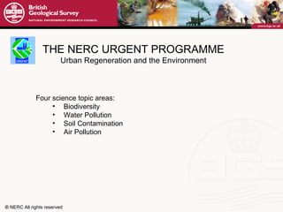
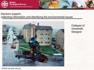
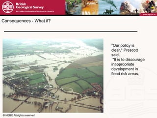
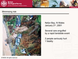
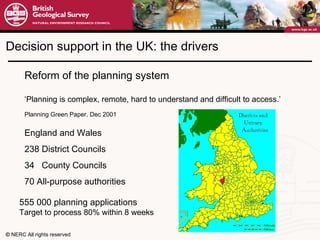
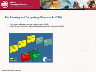
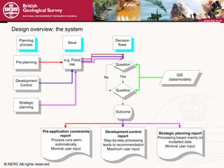
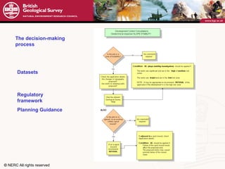
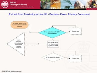
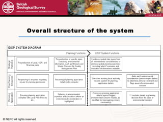
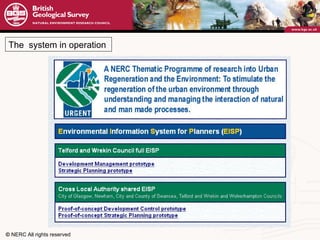
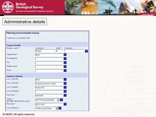
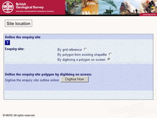
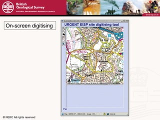
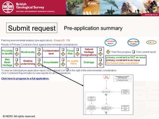
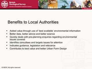
Dave Bridge Environmental Information System for Sustainable Urban Planning
OBJECTIVE To deliver  information systems and decision aids  for use by planners,  developers and other stakeholders involved in urban regeneration
THE NERC URGENT PROGRAMME Urban Regeneration and the Environment £10m programme over 7 years Integrates urban ecological and environmental research across the geological, terrestrial, freshwater and atmospheric sciences partnership with city authorities, industry and regulatory bodies focused on a few UK conurbations, but expected to develop generic models and solutions
THE NERC URGENT PROGRAMME Urban Regeneration and the Environment Four science topic areas: Biodiversity Water Pollution Soil Contamination Air Pollution
Land Quality Management University of Nottingham
Decision support:  collecting information and identifying the environmental issues Collapse of  mineshaft, Glasgow
House collapse at Ferniehill Terrace, Edinburgh,  20 Nov. 2000 Pillar or roof failure in pre-1837 galleries of Ferniehill Limestone Mine Communicating that information and knowledge
"Our policy is clear," Prescott said. "It is to discourage inappropriate  development in flood risk areas.   Consequences - What if?
Minimising risk Nefyn Bay, N Wales January 2 nd , 2001 Several cars engulfed by a rapid landslide event 2 people seriously hurt 1 fatality
Reform of the planning system ‘ Planning is complex, remote, hard to understand and difficult to access.’  Planning Green Paper, Dec 2001   England and Wales 238 District Councils 34  County Councils 70 All-purpose authorities Decision support in the UK: the drivers 555 000 planning applications Target to process 80% within 8 weeks
Each region will have a regional spatial strategy (RSS). Local Planning Authorities will prepare local development documents (LDDs) The Planning and Compulsory Purchase Act 2004
Move towards e-governance Conduct planning business on-line www.planningportal.gov.uk e.g. file a planning application
Design of the Environmental Information System Consultation with five Local Authorities and a consultant planner - pre-application advice  Typically  over 22% of  a District Council’s  Development Control budget is  spent on pre-application advice with a financial cost of £220,000 (source:  Best Value Review  2001). a framework of  development plans (regional spatial strategy, local development plans) Maps and written policies, to show where and in what quantity various types of development will be permitted -  development control  Process by which planning applications are determined
Design Criteria Proof-of-concept demonstrator Decision  support User-led Target Users Web enabled Modular Open and flexible Audit trail Spatial referencing Interface with planning systems
  Key environmental legislation and policy guidance relevant to planning decisions       2000 The Building Regulations 2000 The Contaminated Land Regulations 1999 Town and Country Planning ( Environmental Impact Assessment) E&W Regulations 1995 Environment Act 1994 Waste Management Regulations 1994 Conservation (Natural Habitats etc) Regulations 1992 Access to Neighbouring Land Act 1991 Water Resources Acts  1991 Planning and Compensation Act  1990 Planning (Hazardous substances) Act 1990 Environmental Protection Act  1990 Planning (Listed buildings and Conservation Areas) Act 1990 Town and Country Planning Act 1986 Agriculture (Environmentally Sensitive Areas) Act  1968 Wildlife and Countryside Act 1953 Agricultural Land (Removal of Surface Soil) Act  1949 National Parks and Access to the Countryside Act  Flood Risk PPG 25 Jul 2001 Planning and Noise PPG 24  Sep 1994 Planning and Pollution Control PPG 23 Jul 1994 Coastal Planning PPG 20 Sep 1992 Archaeology and Planning PPG 16 Nov 1990 Planning and the Historic Environment PPG 15 Sep 1994 Development on Unstable Land PPG 14 Apr 1990 Transport PPG 13 Mar 2001 Planning and waste management PPG 10 Sep 1999 Nature Conservation PPG 9 Oct 1994 The Countryside PPG 7 Feb 1997 Greenbelts PPG 2 Jan 1995
Coverage of the prototype system:  Groundwater Land instability Bio-diversity Flood  Risk Air Hedgerows Landfill /  Cont- aminated  Land Heritage Greenbelt
Design overview: the system
The decision-making process Datasets Regulatory framework Planning Guidance
Extract from Proximity to Landfill - Decision Flow - Primary Constraint
Overall structure of the system
Web browser used by local authority planner EISP web server www access protected by  password and firewall GIS Databases/ Models
Research inputs by 2010  limits for PM 10   24 hour mean: 50 µg/m 3  not to be exceeded more than 7 times per year; (London: 50 µg/m 3  not to be exceeded more than 10 times per year)  Models: Air quality
Optimised datasets: Coal Authority Coalbrookdale Coalfield  Shallow undermining Mining Consideration area: Shallow undermining >10 mine entries per cell Subsidence damage licence claim
National scale models: landslip susceptibilty  Ironbridge Gorge Birthplace of the industrial revolution  Development control zones Model based on: 1:10/50k geology Slope angle Lithology Hydrogeology Validated against Landslide database 1 2 3 4 5
The  system in operation
Administrative details
Site location
On-screen digitising
Submit request Pre-application summary
Summary report
 
Application determination
Benefits to Local Authorities Added value through use of ‘best available’ environmental information Better data, better advice and better science  Quickly deals with pre-planning enquiries regarding environmental issues covered Identifies consultees and targets issues for attention Indicates guidance, legislation and relevance Contributes to best value and better Urban Form Design
What next? Feedback: very positive from local authorites but no money Move from prototype to fully implemented system for one local authority Commercialisation of part or parts of the system? Significance in the context of European planning systems?
Demonstration available on request Thanks to the participating local authorities The end

David Bridge presentation, Communicating Environmental Geoscience workshop, Keyworth 2006

  • 1.
    Dave Bridge EnvironmentalInformation System for Sustainable Urban Planning
  • 2.
    OBJECTIVE To deliver information systems and decision aids for use by planners, developers and other stakeholders involved in urban regeneration
  • 3.
    THE NERC URGENTPROGRAMME Urban Regeneration and the Environment £10m programme over 7 years Integrates urban ecological and environmental research across the geological, terrestrial, freshwater and atmospheric sciences partnership with city authorities, industry and regulatory bodies focused on a few UK conurbations, but expected to develop generic models and solutions
  • 4.
    THE NERC URGENTPROGRAMME Urban Regeneration and the Environment Four science topic areas: Biodiversity Water Pollution Soil Contamination Air Pollution
  • 5.
    Land Quality ManagementUniversity of Nottingham
  • 6.
    Decision support: collecting information and identifying the environmental issues Collapse of mineshaft, Glasgow
  • 7.
    House collapse atFerniehill Terrace, Edinburgh, 20 Nov. 2000 Pillar or roof failure in pre-1837 galleries of Ferniehill Limestone Mine Communicating that information and knowledge
  • 8.
    "Our policy isclear," Prescott said. "It is to discourage inappropriate development in flood risk areas. Consequences - What if?
  • 9.
    Minimising risk NefynBay, N Wales January 2 nd , 2001 Several cars engulfed by a rapid landslide event 2 people seriously hurt 1 fatality
  • 10.
    Reform of theplanning system ‘ Planning is complex, remote, hard to understand and difficult to access.’ Planning Green Paper, Dec 2001 England and Wales 238 District Councils 34 County Councils 70 All-purpose authorities Decision support in the UK: the drivers 555 000 planning applications Target to process 80% within 8 weeks
  • 11.
    Each region willhave a regional spatial strategy (RSS). Local Planning Authorities will prepare local development documents (LDDs) The Planning and Compulsory Purchase Act 2004
  • 12.
    Move towards e-governanceConduct planning business on-line www.planningportal.gov.uk e.g. file a planning application
  • 13.
    Design of theEnvironmental Information System Consultation with five Local Authorities and a consultant planner - pre-application advice Typically over 22% of a District Council’s Development Control budget is spent on pre-application advice with a financial cost of £220,000 (source: Best Value Review 2001). a framework of development plans (regional spatial strategy, local development plans) Maps and written policies, to show where and in what quantity various types of development will be permitted - development control Process by which planning applications are determined
  • 14.
    Design Criteria Proof-of-conceptdemonstrator Decision support User-led Target Users Web enabled Modular Open and flexible Audit trail Spatial referencing Interface with planning systems
  • 15.
      Key environmentallegislation and policy guidance relevant to planning decisions     2000 The Building Regulations 2000 The Contaminated Land Regulations 1999 Town and Country Planning ( Environmental Impact Assessment) E&W Regulations 1995 Environment Act 1994 Waste Management Regulations 1994 Conservation (Natural Habitats etc) Regulations 1992 Access to Neighbouring Land Act 1991 Water Resources Acts 1991 Planning and Compensation Act 1990 Planning (Hazardous substances) Act 1990 Environmental Protection Act 1990 Planning (Listed buildings and Conservation Areas) Act 1990 Town and Country Planning Act 1986 Agriculture (Environmentally Sensitive Areas) Act 1968 Wildlife and Countryside Act 1953 Agricultural Land (Removal of Surface Soil) Act 1949 National Parks and Access to the Countryside Act Flood Risk PPG 25 Jul 2001 Planning and Noise PPG 24 Sep 1994 Planning and Pollution Control PPG 23 Jul 1994 Coastal Planning PPG 20 Sep 1992 Archaeology and Planning PPG 16 Nov 1990 Planning and the Historic Environment PPG 15 Sep 1994 Development on Unstable Land PPG 14 Apr 1990 Transport PPG 13 Mar 2001 Planning and waste management PPG 10 Sep 1999 Nature Conservation PPG 9 Oct 1994 The Countryside PPG 7 Feb 1997 Greenbelts PPG 2 Jan 1995
  • 16.
    Coverage of theprototype system: Groundwater Land instability Bio-diversity Flood Risk Air Hedgerows Landfill / Cont- aminated Land Heritage Greenbelt
  • 17.
  • 18.
    The decision-making processDatasets Regulatory framework Planning Guidance
  • 19.
    Extract from Proximityto Landfill - Decision Flow - Primary Constraint
  • 20.
  • 21.
    Web browser usedby local authority planner EISP web server www access protected by password and firewall GIS Databases/ Models
  • 22.
    Research inputs by2010 limits for PM 10 24 hour mean: 50 µg/m 3 not to be exceeded more than 7 times per year; (London: 50 µg/m 3 not to be exceeded more than 10 times per year) Models: Air quality
  • 23.
    Optimised datasets: CoalAuthority Coalbrookdale Coalfield Shallow undermining Mining Consideration area: Shallow undermining >10 mine entries per cell Subsidence damage licence claim
  • 24.
    National scale models:landslip susceptibilty Ironbridge Gorge Birthplace of the industrial revolution Development control zones Model based on: 1:10/50k geology Slope angle Lithology Hydrogeology Validated against Landslide database 1 2 3 4 5
  • 25.
    The systemin operation
  • 26.
  • 27.
  • 28.
  • 29.
  • 30.
  • 31.
  • 32.
  • 33.
  • 34.
    Benefits to LocalAuthorities Added value through use of ‘best available’ environmental information Better data, better advice and better science Quickly deals with pre-planning enquiries regarding environmental issues covered Identifies consultees and targets issues for attention Indicates guidance, legislation and relevance Contributes to best value and better Urban Form Design
  • 35.
    What next? Feedback:very positive from local authorites but no money Move from prototype to fully implemented system for one local authority Commercialisation of part or parts of the system? Significance in the context of European planning systems?
  • 36.
    Demonstration available onrequest Thanks to the participating local authorities The end