URS provides cultural resources services including identifying, assessing, and managing historic properties and paleontological resources to evaluate impacts of projects and achieve compliance. Their experts assist with compliance under NHPA, NEPA, CEQA and can generate environmental reports. URS evaluates impacts of transportation, redevelopment, utilities and other project types, and provides mitigation strategies like data recovery and construction monitoring.
Luis Gutierrez has over 26 years of experience in the US Army and Department of Defense, including serving as a Senior Protection Noncommission Officer and Operations Sergeant Major. He has extensive experience managing large organizations, planning events and ceremonies, and ensuring safety and security. Gutierrez holds degrees in Spanish/Italian and a Masters in Business Administration, and has received multiple awards for his outstanding performance and professionalism throughout his career.
This document provides a summary of Kevin C. Caldwell's professional experience and qualifications. It summarizes that he has over 12 years of experience in human resources and staffing roles within the military. His current role provides brigade level support to US forces in Afghanistan, including processing awards, maintaining status reports, and coordinating mail delivery. Previously he held various human resources roles within the Army and Navy, demonstrating strong skills in personnel management, administrative tasks, and utilizing software programs like PeopleSoft.
Taina Pruitt has over 20 years of experience in intelligence analysis and security roles within the United States Coast Guard. She has collected and analyzed intelligence on issues like illegal migration, drug trafficking, and maritime security threats. Pruitt has also served in leadership positions managing resources, personnel security, and diversity initiatives. Her experience spans roles in intelligence watchstanding, law enforcement, counterdrug operations, and international cooperation in Panama. Pruitt holds an M.S. in Intelligence Management and a B.S. in Government.
This document describes a MATLAB code that analyzes an 8-layer laminate composite made of epoxy fibers and isophthalic polyester matrix. The code calculates the A, B, and D matrices for different laminate configurations defined by the fiber orientation angles and layer thicknesses. It produces 4 carpet plots showing how the laminate's in-plane modulus, Poisson's ratio, shear modulus, and bending modulus vary with the thickness ratio of the +/-45 degree layers. The document provides the material properties, fiber orientation angles used in the case study, descriptions of the MATLAB functions and for-loops used to calculate the results, and the output carpet plots.
Cairn India is committed to conducting its operations in a socially and environmentally responsible manner. This commitment is fundamental to the long term success and focus on creating value and making a difference where Cairn India operates through various community development initiative in Rajasthan, Gujarat, Andhra Pradesh and Sri Lanka. Corporate Social Responsibility (CSR) is therefore an integral part of Cairn India’s business strategy. Cairn India’s success is guided by the CSR vision, which is encapsulated in the 3 Rs – Respect, Relationships and Responsibility.
Ecolab's 2005 annual report provides the following information:
1) Ecolab is the leading global provider of cleaning and sanitizing products and services, serving customers in over 160 countries.
2) In 2005, Ecolab reported net sales of $4.5 billion, a 8% increase from 2004, and net income of $319 million, a 13% increase.
3) Ecolab aims to provide comprehensive solutions and service to customers in industries like hospitality, healthcare, food processing, and commercial laundries.
This document contains information about 22 students in a class including their names, best friends, ages, what grade they were in when they started at this school, and their scores on 4 spelling tests ranging from 70-100%.
1) There is a need to build capacity in constructed wetland management in Malaysia, including developing guidelines, educating stakeholders, and establishing monitoring protocols.
2) Constructed wetlands can treat wastewater, improve water quality, and provide habitat, but their design and maintenance requires expertise across multiple disciplines.
3) Capacity building efforts should provide training, strengthen organizations, and facilitate technology transfer to ensure constructed wetlands' long-term sustainable use.
Marstel-Day is an environmental consulting firm with over 60 staff members and expertise in areas such as conservation, NEPA analysis, sustainability, and encroachment management. Some of their recent projects include developing encroachment control plans for Marine Corps and Air Force installations, performing net environmental benefit assessments at military bases and Superfund sites, and providing policy support on issues like climate adaptation and partnering with external groups on land use. Marstel-Day has experience working with a wide range of government and commercial clients on projects involving environmental analysis, planning and management.
UltraSystems Environmental is an environmental consulting firm established in 1994 that provides environmental documentation, technical studies, and compliance services. The firm specializes in CEQA, NEPA, and other environmental regulations. UltraSystems employs a multidisciplinary team including scientists, engineers, and specialists. It has extensive experience preparing EIRs, EISs, and other CEQA/NEPA documents for both public and private clients in California and other Western states. UltraSystems is committed to developing legally defensible environmental documents and ensuring successful project delivery. It has ongoing contracts with several Southern California agencies to provide as-needed environmental services.
European Ways of Spatial Planning Data Harmonization, TWG Land Use, PLAN4ALL
Sectoral Metadata Profile in Spatial Planning, Local & Foreign Experiences - Internationcal Conference, held by Ministry of Infrastructure, Spatial and maritime Economy, Warsaw, December 1-st and 2-nd, 2011
This document provides a summary of Don Boone's professional experience and education. It details his most recent role as Plans and Requirements Branch Chief for the Air National Guard Readiness Center from 2009 to 2014, where he managed a staff supporting infrastructure projects at 173 ANG installations. Prior to this, he held roles as Design and Construction Program Manager and Facility Manager with increasing levels of responsibility. He has a Master's degree in National Security and Strategic Studies from the US Naval War College and a Bachelor's degree in Landscape Architecture.
This document provides an overview of Section 106 considerations for electric infrastructure projects. It discusses engaging in the Section 106 process early, defining the area of potential effects, identifying and evaluating historic and cultural resources, determining effects of projects, and mitigation strategies. It emphasizes the importance of thorough preparation, high quality data collection, and ongoing consultation with regulatory agencies throughout the project planning and compliance process.
The document discusses how Zetica can assist with infrastructure, environment and archaeology, foundations and geotechnics, ground stability, unexploded ordnance, utility services, surveying and monitoring using non-intrusive survey methods like seismic, electrical, electromagnetic, magnetic, microgravity, and ground penetrating radar surveys. These surveys can help optimize routes, locate hazards and archaeological features, characterize subsurface conditions, and monitor structures.
Darren Williams and Danna Campbell Canada's Approach to Marine Spatial Planni...riseagrant
Canada takes an ecosystem-based approach to marine spatial planning. Its marine areas support significant economic activity but also have high ecological value. Growing marine uses require proactive planning to minimize conflicts and protect ecosystems. Canada's approach involves defining planning areas, assessing human uses and ecosystems, identifying valued components and conservation objectives, and using risk assessment and spatial analysis to guide management. The goal is integrated management that allows for optimal human use while maintaining healthy marine ecosystems.
GIS was an essential tool for the author in their role developing wind farm projects at Eolectric. The author used GIS for 50% of their work, which included tasks like identifying suitable sites, evaluating wind resources, assessing environmental constraints, designing wind farm layouts including turbine and road placement, and creating maps for public permitting and internal analysis. GIS allowed the author to efficiently manage spatial data, create customized maps for different audiences and purposes, and iteratively evaluate and modify wind farm designs.
The document discusses how spatial planning and development control measures do not always adequately address the historic environment. It explores how tools like Historic Landscape Characterisation could help bridge the gap by addressing the issue of significance. Significance can be evaluated using concepts from organizations like English Heritage, which provide guidance on assessing heritage values and integrity to help inform planning decisions that have long-term impacts.
Stephen Kuhlman seeks a position providing data management support for geologic interpretation in oil and gas exploration. He has over 20 years of experience managing geospatial datasets including seismic data, well logs, and geologic models. His skills include GIS analysis, 3D modeling, database management, and software such as Petrel, Rockworks, and ArcGIS. He holds a B.Sc. in Geophysics and has worked on projects involving environmental remediation and oil/gas exploration.
Bruce Carlisle Massachusetts Ocean Management: Capacity to develop and implem...riseagrant
The document discusses Massachusetts' capacity to develop and implement an ocean management plan. It summarizes that the state developed the plan through stakeholder engagement, data collection, and technical analysis. The plan designates prohibited, renewable energy, and multi-use areas. Implementing the plan requires state agency collaboration, advisory bodies, and partnerships. Key resources include political support, staff expertise across disciplines, and the Massachusetts Ocean Partnership providing $4.5 million in support. Ongoing implementation and stakeholder engagement are also essential to address science gaps and regulatory needs.
This document discusses Hawaii and Pacific Basin orthoimagery updates. It provides an overview of recent and planned orthoimagery acquisitions by USDA-NRCS in Hawaii and the Pacific Basin. Key points include:
- USDA-NRCS has collected high-resolution orthoimagery for nearly all land areas in Hawaii and the Pacific Basin using satellite imagery.
- Recent acquisitions include new DigitalGlobe WorldView-2 imagery for all Hawaiian islands, providing the first statewide coverage with 8-band multi-spectral data.
- Plans are outlined to acquire additional imagery for Hawaii island and other areas in 2012 to fill gaps and improve cloud coverage.
- Distribution of the imagery
Presentation for architects to encourage expanding the programming and design process to include defensive strategies against natural and man-made disasters.
The WHM Group is an environmental consulting firm that provides services such as natural resource management, permitting, and ecological assessments. It has extensive experience working with state and federal agencies on projects involving threatened and endangered species. The firm takes a comprehensive approach to solving environmental problems while balancing business and regulatory interests.
Cave springs master plan ppt for stakeholder workshop june 2015Michael Reles
The document provides information about the Cave Springs Management Plan stakeholder workshop. It outlines NPCA values, describes the Cave Springs property and classifications, discusses the purpose and objectives of the management plan study, outlines project timelines and tasks, and introduces the project support team and steering committee. The overall goal is to develop a management plan that protects the natural and cultural heritage features of Cave Springs while allowing appropriate public access and recreation.
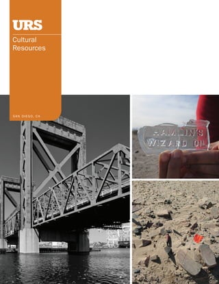
2. EXPERIENCED EXPERT
URS provides an extensive range of services to identify, assess URS archaeologists and architectural historians possess con-
and manage cultural resources. We work with commercial, in- siderable experience in the identification and evaluation of his-
dustrial and government entities to identify resources, assess toric properties, and analysis of effects in support of Section
impacts, avoid or minimize adverse effects and achieve project 106 of the NHPA, NEPA, and CEQA. Similarly, URS paleontolo-
success criteria through planning and management strategies. gists have extensive knowledge of and practice identifying
The strengths of our archaeologists, architectural historians and evaluating local and regional paleontological resources
and paleontologists lie in their broad experience and technical in support of the National Natural Landmark (NNL) program.
expertise to carry out activities such as resource inventories, We provide services to evaluate the environmental impacts of
evaluations, data recovery, construction monitoring, regulatory transportation infrastructure, redevelopment, public utility, in-
permitting and NHPA, NEPA, and CEQA compliance. In addition, dustrial and power generation and disaster planning and relief
our Cultural Resources Team has successfully generated envi- projects.
ronmental document sections (AFC, EA/EIR/EIS/LEIS, IS/ND/
MND, FONSI), management documents (HPMP HPTP CRMMP
, , ,
ICRMP) and agreement documents (MOU, MOA, PA, NAGPRA
POA/CA), as well as their respective supporting technical re-
ports. For both large and small projects, our clients benefit
from our depth of resources, technical expertise and timely
response.
WE PROvIDE SERvICES TO EvALUATE THE ENvIRONMENTAL IMPACTS OF TRANSPORTATION
INFRASTRUCTURE, REDEvELOPMENT, PUbLIC UTILITy, INDUSTRIAL AND POWER GENERATION
AND DISASTER PLANNING AND RELIEF PROjECTS.
3. SERVICES
• Section 106 of the NHPA, NEPA, CEQA, National Natural
Landmarks Compliance
• Secretary of Interior Standards for the Treatment of Historic
Properties
• National, State, Local Register and National Registry of
Natural Landmarks Evaluations and Nominations
• Environmental Document sections (AFC, EA/EIR/EIS/LEIS,
IS/ND/MND, FONSI)
• Management Documents (HPMP HPTP CRMMP ICRMP)
, , ,
• Agreement Documents (MOU, MOA, PA, NAGPRA POA/CA)
• Technical Reports (ARMR)
• Historic Structures Report/Cultural Landscape Reports
• HABS/HAER/HALS/CRGIS
• Viewshed Analysis
• Preservation Case Studies
• Building Relocation Studies
• Historic Context Studies
• Archival Research/Records Search
• Large-scale Intensive and Reconnaissance Surveys
• Mitigation Development and Implementation programs
including data recovery, construction monitoring, and public
outreach programs
• Consultation with project engineers and regulatory agencies
at the federal, state, and local level
• Local Government and Stakeholder Coordination and
Consensus Building in support of Lead Agency consultation
proFessionAl
urs professionals meet the secretary of interior Qualifications
in Archaeology, Architectural history, history and preservation
planning (36 cFr part 61). they are knowledgeable of the
laws and ordinances which affect historic properties, such as
section 106 of the nhpA, ceQA, california public resources
code, state historic Building code, the secretary of interior
standards for the treatment of historic properties and the
nnl program (36 cFr 62) . they are members of various na-
tional, state, and local archaeological, historical, architectural
history, preservation and paleontology organizations. the urs
cultural resources team includes registered professional
Archaeologists, individuals who meet professional Qualification
standards (in Archaeology and historic preservation; secretary
of the interior’s standards and guidelines [48Fr190:44738-
44739]) and certified paleontologists. our senior staff are rec-
ognized experts within their fields and active contributors to
professional resource management organizations.
comprehensive expertise in ArchAeology,
ArchitecturAl history And pAleontology