The CPDC GeoDesign Studio provides students real-world experience applying new technologies and multidisciplinary solutions to campus planning projects. Students work on projects such as improving bike infrastructure, creating 3D campus maps, analyzing wildlife habitats, and designing sustainable furniture. The studio collaborates with various academic departments and allows students to develop skills in GIS, design, and environmental analysis that prepare them for careers in related fields.


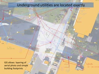
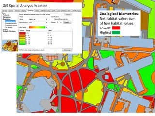
![GIS and CAD
datasets were
combined to
produce this
map, with light
poles overlaying
low [yellow]
and high voltage
[dark blue]
electrical lines
to illustrate the
underground
lighting circuit.
Street Lighting Circuit Mapping Exam](https://image.slidesharecdn.com/86b4fa54-59c0-414d-baca-9971967b8921-150429214624-conversion-gate01/85/CSU-Full-Engagement-Proposal-12-320.jpg)