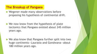
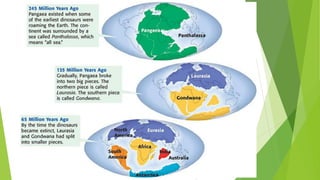
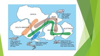
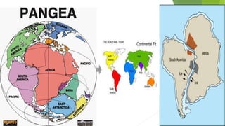
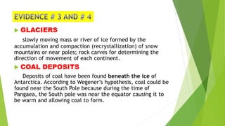
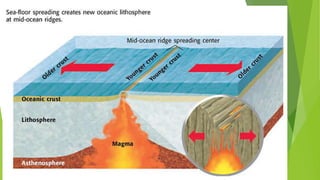
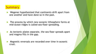
3. Wegener’s Continental Drift Hypothesis
In the early 1900s, Alfred Wegener (VAY guh nuhr),
German geo phycisist, researcher and geologist
wrote about his hypothesis of continental drift.
Continental drift is the hypothesis that states
that the continents once formed a single
landmass, broke up, and drifted to their present
locations. Wegener called this continent Pangaea
(pan JEE uh), which is Greek for “all earth.”
surrounded by PANTHALASSA “all seas”
4.
5. The Breakup of Pangaea
Wegener made many observations before
proposing his hypothesis of continental drift.
We now know from the hypothesis of plate
tectonics that Pangaea existed about 245 million
years ago.
We also know that Pangaea further split into two
huge continents—Laurasia and Gondwana—about
180 million years ago.
6.
7. FOSSILS
Same plant and animal species remains are found on
continents that are on different sides of the Atlantic Ocean.
Many of these ancient species could not have crossed the
Atlantic Ocean.
MESOSAURUS
LYSTROSAURUS
CYNOGNATHUS
GLOSSOPTERIS
8.
9.
10. GEOLOGIC FIT
a. Puzzle- fit continents
Ex. South America and West Africa
b. Rock terrains – physical features/ geographic area
Ex. Appalachian Mountains North America- Scottish Highlands
Karroo System South Africa- Santa Catarina Brazil
Brazil and Ghana Mountain ranges- Atlantic ocean
11.
12. GLACIERS
slowly moving mass or river of ice formed by the
accumulation and compaction (recrystallization) of snow
mountains or near poles; rock carves for determining the
direction of movement of each continent.
COAL DEPOSITS
Deposits of coal have been found beneath the ice of
Antarctica. According to Wegener’s hypothesis, coal could be
found near the South Pole because during the time of
Pangaea, the South pole was near the equator causing it to
be warm and allowing coal to form.
13. Sea-Floor Spreading Theory
When Wegener put forth his hypothesis of
continental drift, many scientists would not
accept his hypothesis.
From the calculated strength of the rocks, it did
not seem possible for the crust to move in this
way.
During Wegener’s life, no one knew the answer. It
wasn’t until many years later that evidence
provided some clues to the forces that moved the
continents.
14. Mid-Ocean Ridges and Sea-Floor Spreading
A chain of submerged mountains
runs through the center of the
Atlantic Ocean.
The chain is part of a worldwide
system of mid-ocean ridges. Mid-
ocean ridges are underwater
mountain chains that run through
Earth’s ocean basins.
15.
16. Mid-Ocean Ridges Continued
Mid-ocean ridges are places where sea-floor spreading
takes place.
Sea-floor spreading is the process by which new oceanic
lithosphere forms as magma rises toward the surface and
solidifies.
As the tectonic plates move away from each other, the sea
floor spreads apart and magma fills in the gap.
As this new crust forms, the older crust gets pushed away
from the mid-ocean ridge.
As Figure 3 shows, the older crust is farther away from
the mid-ocean ridge than the younger crust is.
17. Evidence for Sea-Floor Spreading: Magnetic
Reversals
Some of the most important evidence of sea-floor
spreading comes from magnetic reversals
recorded in the ocean floor.
Throughout Earth’s history, the north and south
magnetic poles have changed places many times.
When the poles change places, the polarity of
Earth’s magnetic poles changes
When Earth’s magnetic poles change places, this
change is called a magnetic reversal.
18.
19.
20.
21.
22.
23. Magnetic Reversals and Sea-Floor Spreading
The molten rock at the mid-ocean ridges contains tiny
grains of magnetic minerals.(MAGNETITE)
These mineral grains contain iron and are like compasses.
They align with the magnetic field of the Earth.
When the molten rock cools, the record of these tiny
compasses remains in the rock.
This record is then carried slowly away from the spreading
center of the ridge as sea-floor spreading occurs.
24. Magnetic Reversal Continued
When the Earth’s magnetic field reverses, the magnetic
mineral grains align in the opposite direction.
The new rock records the direction of the Earth’s magnetic
field.
As the sea floor spreads away from a mid-ocean ridge, it
carries with it a record of magnetic reversals.
This record of magnetic reversals was the final proof that
sea-floor spreading does occur.
25.
26. GUIDE QUESTIONS
1. Identify the 3 spreading centers in the data table.
2. What type of boundary is being described in the data table?
3. Explain the rate differences between the 3 spreading centers by
answering the following questions;
a. Which spreading center is the slowest in terms of average spreading
rate per year? fastest in terms of average spreading rate per year?
b. Slower spreading rates lead to a rough topography because the
tectonic plate is allowed to cool before moving away from the ridge.
Slow spreading rates also form deep central rift valleys. Faster spreading
rates lead to a smoother oceanic surface because the tectonic plate is
warmer and has less deformation.
Based on the description above, which spreading center leads to rough
topography? Smooth topography?
27.
28. Age of
the line
in
millions
of years
Distance
from the
ridge in
map (use
ruler to
measure in
millimeter)
Distance
from the
ridge in
kilometer
(scale:
1mm= 65
km)
Actual
distance
answer in
column 3 (to
be
converted
into
centimeter)
Rate of
Seafloor
spreading
(cm
divided by
age)
9
38
53
63
81
135
155
180
29. GUIDE QUESTIONS
1. What is the role of the mid- ocean ridge in the movement of
lithospheric plates?
2. Based on scientific findings, how does the new seafloor form at the
mid- oceanic ridge?
3. How are magnetic stripes useful in determining the rate of sea floor
spreading?
4. What is the average rate of sea floor spreading in the activity?
5. Using the average rate you computed in question number 3, answer
the problem below;
If Africa is approximately 2400 km away from the ridge, how long ago
was it when Africa was directly at or near the ridge?
6. Which theory explains plate movement, Continental Drift Theory or
Seafloor Spreading Theory? Explain your answer.
30. Summary
Wegener hypothesized that continents drift apart from
one another and have done so in the past.
The process by which new oceanic lithosphere forms at
mid-ocean ridges is called sea-floor spreading.
As tectonic plates separate, the sea floor spreads apart
and magma fills in the gap.
Magnetic reversals are recorded over time in oceanic
crust.