Download as PDF, PPTX

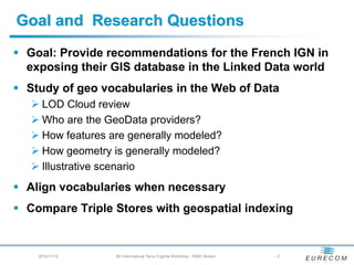
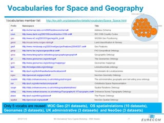
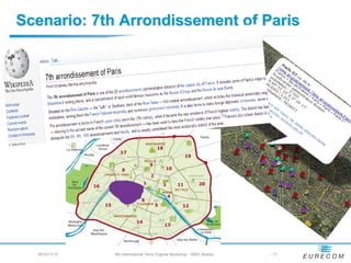
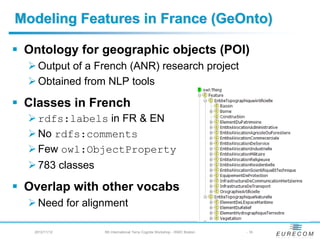
![Feature and Geometry
Term Definition Source
An abstract representation of a real-world [INSPIRE
phenomenon related to a specific location Directive]
Spatial Object = or geographical area . It should be noted Item 67
(Geographical) Feature that the term has a different meaning in
the ISO 19100 series. It is also
synonymous with "(geographic) feature"
as used in the ISO 19100 series.
Feature A geographical feature, capable of holding NeoGeo
spatial relations. Vocab
A top-level geometry type. This class is
Geometry equivalent to the UML class GM_Object GeoSPARQL
defined in ISO 19107, and it is superclass [OGC]
of all geometry types.
2012/11/12 5th International Terra Cognita Workshop - ISWC Boston -4](https://image.slidesharecdn.com/atemezing-talk-terracognita2012-1-121112110808-phpapp02/85/Comparing-Vocabularies-for-Representing-Geographical-Features-and-Their-Geometry-4-320.jpg)
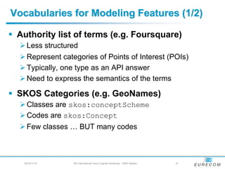
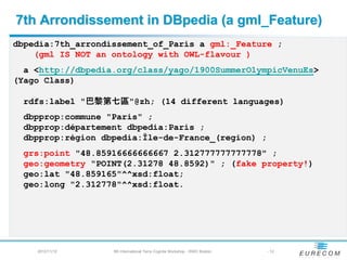
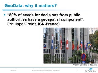
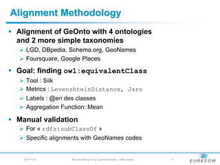
![7th Arrondissement in GeoNames (a A.ADM4)
gnr:6618613 a gn:Feature ; gn:name "Paris 07";
gn:alternateName "7ème arrondissement";
gn:featureClass gn:A [
a skos:ConceptScheme ;
rdfs:comment "country, state, region ..."@en .
] ;
gn:featureColde gn:A.ADM4 [
a skos:Concept ;
rdfs:comment
"a subdivision of a third-order administrative division"@en .
];
gn:countryCode "FR";
gn:population "57410";
geo:lat "48.8565";
geo:long "2.321".
2012/11/12 5th International Terra Cognita Workshop - ISWC Boston - 13](https://image.slidesharecdn.com/atemezing-talk-terracognita2012-1-121112110808-phpapp02/85/Comparing-Vocabularies-for-Representing-Geographical-Features-and-Their-Geometry-13-320.jpg)
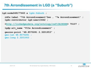
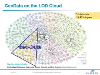
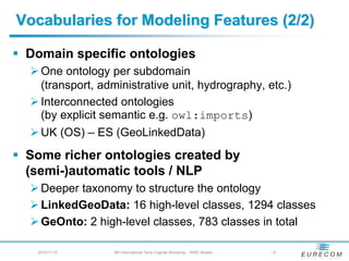
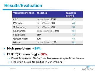
![Alignment Process with GeoNames
geOnto:AGeoConcept a • Look for skos codes that
owl:Class; matches GeOnto classes
rdfs:label “a label”@en; • Verify the links <70%
Silk • Generate « sameAs » links
rdfs:subClassOf gn:Feature;
owl:equivalentClass
[a owl:Restriction;
owl:onProperty • Use SPARQL
« Construct » to generate
gn:featureCode; SPARL a new graph.
owl:hasValue gn:CODE. ] Endpoint
• Export the rdf file
Alignment
File
2012/11/12 5th International Terra Cognita Workshop - ISWC Boston - 18](https://image.slidesharecdn.com/atemezing-talk-terracognita2012-1-121112110808-phpapp02/85/Comparing-Vocabularies-for-Representing-Geographical-Features-and-Their-Geometry-18-320.jpg)

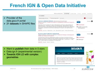

The document compares vocabularies for representing geographical features and geometry on the semantic web. It finds that few vocabularies are widely reused, including W3C Geo, OS spatial relations, and NeoGeo. Feature modeling approaches include authority lists, SKOS categories, and domain ontologies. Geometry is modeled using points, rectangles, lists of points, and more structured representations. The document also provides recommendations for publishing French geographical data as linked data, such as using suitable ontologies to represent complex geometries and connecting features to geometry.


