Chapple, R. M. 2014 Archaeology of Gatherings Conference. Institute of Technology, Sligo, Ireland. October 2013. Part IV. Blogspot post
•
0 likes•78 views

Chapple, R. M. 2014 Archaeology of Gatherings Conference. Institute of Technology, Sligo, Ireland. October 2013. Part IV. Blogspot post

Recommended
Recommended
More Related Content
Viewers also liked
Viewers also liked (20)
Similar to Chapple, R. M. 2014 Archaeology of Gatherings Conference. Institute of Technology, Sligo, Ireland. October 2013. Part IV. Blogspot post
Similar to Chapple, R. M. 2014 Archaeology of Gatherings Conference. Institute of Technology, Sligo, Ireland. October 2013. Part IV. Blogspot post (20)
More from Robert M Chapple
More from Robert M Chapple (11)
Recently uploaded
Recently uploaded (20)
Chapple, R. M. 2014 Archaeology of Gatherings Conference. Institute of Technology, Sligo, Ireland. October 2013. Part IV. Blogspot post
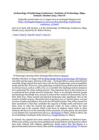
- 1. Archaeology of Gatherings Conference | Institute of Technology, Sligo, Ireland | October 2013 | Part IV Originally posted online on 27 August 2014 at rmchapple.blogspot.com (http://rmchapple.blogspot.co.uk/2014/08/archaeology-of-gatherings- conference_27.html) And we’re back with Session 4 of the Archaeology of Gatherings Conference, Sligo, October 2013, chaired by Dr. Robert Hensey < Part I | Part II | Part III | Part V | Part VI > TJ Westropp's drawing of the Turlough Hill enclosure (Source) Suitably refreshed, we began with Dr Stefan Bergh (Dept of Archaeology, NUI Galway) who delivered the paper: Meeting at the edge – Turlough Hill as a place of prehistoric assembly. Bergh argued that many sites were the foci of gatherings, such as megalithic tombs and the like. However, many gatherings would have been held at sites that leave no obvious traces, such as a cliff, a tree, or a waterfall. Our challenge in these instances is to understand the ‘place making process’. One important focus in this endeavour is to understand how people perceive landscape. There is an interplay between people and landscape that Bergh sees, not just in terms of the creation of monuments, but in their daily lives. These mental and physical landscapes play significant roles in the creation of belief systems. Mountains have long been seen as ‘special’ places, not just in terms of safety and defence, but as the foci for belief systems. One of the reasons for their specialness is that they symbolise the capacity to bridge earth and heaven and allow entry to what lies beyond the physical world. In some cultures the most important spot is the summit, which is the focus of religious ritual, while in other instances the focus is on the verticality of the mountain. In some places, the mountain is not climbed, but venerated from afar (e.g. Mt Kailash in Tibet), while in others, the act of climbing is itself part of the ritual (e.g. Croagh Patrick, Co. Mayo). In Ireland, the uplands have been actively used from prehistory to Medieval times. While some of these uses have been political and social (defence and domestic), others have been imbued with religious significance. Bergh argues that The Burren is a physical boundary between county Clare and the lowlands of south Galway. To anyone
- 2. approaching from this direction it appears as a gigantic grey wall. At Turlough Hill the archaeological remains include a large cairn and house foundations on the western summit and a large enclosure on the eastern summit. This latter enclosure is roughly hexagonal and measures c.220m across. Berg points out that it is clearly not a defensive structure as it has over ten defined entrances and is, in any event, merely composed of a low bank. Thomas Johnson Westropp, when writing about this site in the early 20th century, described it as a temple rather than a domestic rath/ringfort or cashel. The cairn on the western summit still retains some evidence of vertical walling, but has never been excavated to comprehensively determine date and function. The same area also holds 156 identified houses. These occur in clusters of three to four examples, but are not evenly distributed across the summit – they appear to occur at both ends of the summit and near the central area. There appears to be no topographical reason for these intervening blank areas, However (if I understood Bergh correctly) one of these supposed ‘blanks’ has recently shown to contain an enclosure composed of four low, concentric banks. In the saddle between Turlough Hill’s twin peaks there is a long cairn (c.95m x c.6m) that includes at least one megalithic chamber. In many respects, the site may be paralleled with Mullaghfarna, Co. Sligo, where survey has recorded 153 houses of Neolithic and Bronze Age dates. Bergh suggests that the morphology of the cairn and the houses at Turlough Hill suggests a similarly Bronze Age to Neolithic date. The hexagonal enclosure is unique within Irish archaeology, but it may well be of a similar age. Bergh is at pains to point out that this is not ‘just another hill top’. The houses have no parallels within the Burren area. They are not ordinary prehistoric farmsteads. As there is no apparent overlapping of developments, he argues that they represent a single, concerted phase of deliberately planned building. He believes that they were not domestic in function as the hill was not easily accessible and was generally inhospitable. On a personal note, I can very much agree with Bergh’s thinking on this last point. In my days as a Boy Scout, our troop (4th Galway Craughwell) was often to be found wandering through various parts of the Burren. On one large-scale camping weekend event (known as a 'Sionnach Adventure') I, as a senior Scout, was given the job of maintaining a safety checkpoint for the groups as they passed over Turlough Hill. I set up my checkpoint in the lee of what I now know to be the large, kerbed cairn and with several hours to kill, I set about reading Isaac Asimov’s I, Robot (why that particular detail remains so clear after all these years, I have no idea!). It was early summer and the sky was remarkably clear and the sun was warm – very warm. I remember that, despite having come well-prepared, I was soon out of water and was reduced to begging small amounts from the groups as they passed through the checkpoint. There was no easily available water for some distance – both horizontally and vertically. While the sun shone and the breeze was low it was a very pleasant place to be – so long as you were well provisioned. At around the same time in my life – and as part of my Boy Scout adventures – I have been on Turlough Hill on a number of wintery evenings as it got dark and the wind picked up and the rain came down. On these occasions it was not quite as charming as one was alternately soaked and buffeted. Whatever about my childhood observations of the place, Bergh argues that the location was used by two groups coming together. Turlough Hill is on the very edge of the Burren and Bergh suggests that this liminal location was one where the local people could have met outsiders. Whatever role the site played, the surviving remains are without counterpart and, he argues, has important significance for the people of the area and beyond.
- 3. Copney Circle A in 1998 (Source) Under the same night sky - the architecture and meaning of Bronze Age stone circles in mid-Ulster was the topic of Michael Mac Donagh’s (National Roads Authority) presentation. He began with the broad statement that he was going to present a pretty odd take on these sites and that he’d be happy if even one person came away thinking that there was some merit in his theory. With this idea of impending controversy hanging like tantalising bait before us, he began to set the scene: stone circles as a whole, are architecturally very varied and of a wide variety of dates. Together, these facts may be taken to suggest that they also had a similarly wide variety of uses. The mid-Ulster group of stone circles comprises over 100 examples. Where they have been investigated, they appear to have become overgrown with blanket peat around 800 BC, so would appear to be of Bronze Age date. Two of the most important of these complexes are to be found at Copney (Foley 1983; 2010; Foley & McDonagh 1998; MacDonagh 1998) and Beaghmore (Pilcher 1969; 1975; Thom 1980; Hayes 1999), both in Co. Tyrone. These are, for the most part, made up of small, low-set, stones and arranged in groups of more than one circle. Mac Donagh argues that it’s not fanciful to assume that there was a design to their layout. At Beaghmore the design is dominated by five circles and various double-row alignments. Copney was discovered in 1982 and was partially stripped and excavated in 1994 and 1997. At that time three of nine circles (A-C) were wholly or partly exposed. Further work in 1998 – that I was lucky enough to dig on [photo: here] – uncovered two further circles in the complex (J & K). Mac Donagh made the case that at Beaghmore Circles A and B are circular, so it is clear that the people of Bronze Age Tyrone were able to produce circular circles if they so wanted. However, Circle C is not perfectly circular and, rather than see it as an aberration or a failure in ancient technology, he asks if this is not evidence of a deliberate action? There is a similar lack of circularity at Copney and Mac Donagh asks if these are not evidence that these circles were designed in this way? At both sites the circles are laid out with two circles together and a third at a distance. The same layout is also visible at the Tremoge stone circles (which I also dug on in 1998 [photo: here | here | here] … though I didn’t consider myself quite so lucky … it was a horrible waterlogged, nasty site … and the locals broke in to our site hut and stole our tools and kettle … and pushed the portable toilet over). Mac Donagh suggests that the
- 4. same pattern may possibly also occur at the Culvacullion stone circles too. He argues that between all these sites there is evidence for a ‘Grand Design’ template. The tricky question is: what is the origin of that template? Mac Donagh notes that there is a long- established framework that sees the sites (the paired stone rows in particular) as linked to the observation of the heavens on key dates. Little attention has been paid to the layout of the multi-circle complexes themselves. Circles A-C, Copney, Co. Tyrone (Source) Mac Donagh has co-opted the assistance of two nine-year-old girls to produce drawings of the moon. Even at this young age, and using only the naked eye, they can perceive and depict ‘globularity’ in the ‘face’ of the moon. Personally, I’m deeply suspicious of any attempt to reflect the thoughts and actions of ancient peoples in the thoughts and actions of ‘pure’ and ‘untutored’ modern children. Nonetheless, Mac Donagh’s point is well made – the non-circularity of the lunar maria are observable even to young children, not predisposed or (we must suppose) pre-instructed on the topic. Indeed, under the correct conditions, the features of the moon are clearer still. For example, at the times of a perigee moon (or ‘Supermoon’) our natural satellite is up to 50km closer than usual. Under these conditions, the moon appears 14% larger and 30% brighter than one at its farthest point, or apogee. Mac Donagh urges us to shed the notions of astronomical accuracy, and instead view the creators of these places as ‘ritual artists’. Going back to the early written record, Plutarch’s (c.46- 120AD) On the Face in the Moon's Orb noted the existence of the lunar maria. In the same work he describes the moon as ‘the finest and clearest of all mirrors’. The Wikipedia article on the exploration of the moon notes that prior to this time ‘It had been suggested already in antiquity that the Moon was a perfect mirror and that its markings were reflections of earthly features’. Mac Donagh notes that the mathematician, astronomer, and philosopher ibn al-Haytham (c.965-c.1040) wrote of the moon as a mirror; as did Alexander von Humboldt (1769-1859). This is obviously
- 5. a theory of remarkable longevity. Could it have been the same going further back into prehistory? Did the people of Bronze Age Tyrone see the moon as a reflected image of the earth? If they did, it may demonstrate a commonality of shared beliefs across wide geographical and temporal arenas. Having shown a broadly similar ‘template’ could be posited for many of these sites, he attempted to argue that these were inverted human representations of the lunar maria. He takes the position that Beaghmore (the best preserved and most thoroughly uncovered of all the sites) may be interpreted in this way … though there would still be the need to find two additional circles in the unexplored peat land. Mac Donagh continued on in this vein for a while longer, but I’d given up taking notes. I’d come to feel that it was a lovely little theory and a great conference paper, but that it had more to do with Michael’s ability to draw together disparate strands of evidence and pseudo-evidence, weaving them into an (apparently) robust argument. However, the hypothesis was as flimsy as moonlight and, no matter how interesting and comedic the delivery, it was no more than nonsense. This wasn’t archaeology. I was not convinced. And yet … I couldn’t get the idea out of my head … I’ve been thinking about this for over three months now and, while I’m still convinced that he’s wrong in areas, I’m beginning to see that his ideas do have merit. It appears that I have fallen prey to this idea – I’m the one in the audience who came away thinking there was something in the theory! Let it sink in and ruminate on it a while … maybe you too will be seduced by Mac Donagh’s ‘lunacy’. Note: this paper is based on the recently published paper: McDonagh, M. 2014 ‘Under the Same Night Sky – The Architecture and Meaning of Bronze Age Stone Circles in Mid-Ulster’ in Ginn, V., Enlander, R., & Crozier, R. (Eds) Exploring Prehistoric Identity in Europe: Our Construct or Theirs? Oxford. Carrigatogher (Harding) Site 6, Co. Tipperary (Source) The last paper of the day was Gathering the Nations: Kingdoms, Communities and Civil Society in Early Medieval Ireland by Patrick Gleeson (UCC). He started by outlining the idea that, within Early Medieval Ireland, the hierarchical nature of kingship demanded that different societal layers and scales had their own tailored landscapes of assembly. On this basis, we may infer that there was anything from a minimum of 200-600, and up to a maximum of 1500-2000, different assembly spaces
- 6. at any one time during this period. Of these, the most important was the Óenach. The word derives from óen, meaning ‘one’ and is today most associated with markets or fairs. However, during the Early Medieval period it was a place and an occasion for rendering tribute and included horse-racing, games of various kinds, feasting, and entertainment, along with holding numerous legal and judicial aspects. It is the association of the Óenach with these latter functions that placed this form of gathering at the centre of contemporary civil society. Despite their importance, and presumed ubiquity, relatively few Óenach landscapes have been identified. To address this imbalance, The Óenach Project was established at UCC, and funded by an IRCHSS New Ideas grant. The project is dedicated to the research of the origin, nature, and evolution of assembly practices and previously unidentified gathering sites. So far, some 115 Óenach sites have been identified. Examples include Carrigatogher (Harding), Co. Tipperary, and the Kilmainham complex, Co. Meath, the latter including a boundary ditch dated to the Iron Age. At Holdenstown 1, Co. Kilkenny, Iron Age ring ditches were reused in the Early Christian period. Emerging trends from this research include the observation that the boundaries of túatha (singular: túath) were frequently marked with ogham stones and human burials. Of particular interest was Gleeson’s argument that assembly sites at the túath level may be identified at cemetery settlements, indicating a kingly control of burial within society at this time. All together, Gleeson – in a paper that was remarkably dense and delivered at Gatling-gun speed – demonstrated that this form of targeted multi-discipline research can pay huge dividends and help develop a wider appreciation of these Óenach landscapes. After a group question and answer session, the conference closed for the evening and the delegates retreated to the Glasshouse Hotel for what turned out to be a sumptuous conference dinner. < Part I | Part II | Part III | Part V | Part VI > References Foley, C. 1983 ‘A stone circle complex at Copney Hill, County Tyrone’ Ulster Journal of Archaeology 46 (3rd Series), 146-148. Foley, C. 2010 ‘Public space and architecture: the phenomenon of Copney stone circles’ in Murray, E. & Logue, P. (eds.) Battles, boats & bones: archaeological discoveries in Northern Ireland 1987-2008. Belfast, 28-31. Foley, C. & McDonagh, M. 1998 ‘Copney stone circles - a County Tyrone enigma’ Archaeology Ireland 12.1, 24-28. Hayes, T. D. 1999 ‘Using astronomy in archaeology with a look at the Beaghmore alignments’ Ulster Journal of Archaeology 58 (3rd Series), 32-42. MacDonagh, M. 1998 ‘Abstract: under the bog at Copney’ IAPA Newsletter 26, 9. Pilcher, J. R. 1969 ‘Archaeology, palaeoecology, and 14C dating of the Beaghmore stone circle site’ Ulster Journal of Archaeology 32 (3rd Series), 73-91. Pilcher, J. R. 1975 ‘Finds at Beaghmore stone circles, 1971 and 1972’ Ulster Journal of Archaeology 38 (3rd Series), 83-84. Thom, A. S. 1980 ‘The stone rings of Beaghmore: geometry and astronomy’ Ulster Journal of Archaeology 43 (3rd Series), 15-19.