SlideShare a Scribd company logo
1 of 19
Download to read offline
Change Detection of Forest Fire in Los Angeles,
California; Using Landsat5 TM Satellite Imagery


          Munshi Khaledur Rahman (KHALED)
                    Department of Geography
                   University of Northern Iowa
           Remote sensing of the Environment (970:173g)
                     December 16th, 2009
Outline
 Introduction
 Study area and data used
 Methodology
 Results
 Limitation
 Conclusion and future direction
 References
Introduction

 Forest fire is a frequent and constant natural disaster in
    California, USA
   The Station Fire (26 August -16 October, 160,577 acres
    (251 sq mi; 64,983 ha)
    209 structures destroyed, including 89 homes
   Two firefighters were killed on 30 August
   The blaze threatened 12,000 structures in the National
    Forest and the nearby communities
Study Area


Figure: Los Angeles, California Forest Fire
Data Used
 Landsat-5 TM image of October, 2007 and Landsat5 TM
  image of October, 2009
 with 0% cloud
 Landsat5Thematic Mapper (TM), from USGS Landsat
  achieve
 5 bands excluding band 6 and band 7.
Landsat5 TM Imagery


Image 2007, Source: USGS      Image 2009, Source: USGS
Methodology


  Figure: Flow chart
Methodology continue

 Clip target area for before and after fire both the 2007 and
    2009 Image
   Normalized Difference in Vegetation Index (NDVI)
   Supervised Classification
   Unsupervised Classification
   Extraction of Forest
   Change Detection
   Final output
NDVI For Both Images (2007+2009)


Figure: 2007 Image after NDVI   Figure: 2009 Image after NDVI
Unsupervised Classification


 I performed the
  unsupervised
  classification classified as
  15 classes
 Recoded as 4 classes for
  the image 2009 (after
  fire)


                                 Figure: Unsupervised Classification of 2009 Image
Supervised Classification

 Supervised Classification for
  2007 image only
 Took helpe of Unsupervised
  Class attribute of 2009 Image
 Recoded as 3 classes


                                  Figure: Supervised classification of 2007 image
Perform Change Detection
 Change detection is a
  process that measures how
  the attributes of a particular
  area have changed between
  two or more time periods
 Year ‘07 and ’08 extracted
  forest area as input file


                                        Figure: Changedection
Result

 The Los Angles forest fire has occurred in September,
  2009.

 Using NDVI clearly showed the real land cover in the Los
  Angels forest area and showed the areas affected by fire.

 Results of image classification and change detection show
  very clearly the location affected by forest fire

 Multi spectral Landsat data can be used for delineating the
  forest fires
Limitations

 Multispectral imagery availability and real time data availability
 If it is possible then I would like to go to the field and
  observe the real situation and then can predict the accuracy
  in full confident
 It was hard to differentiate between classification errors and
  areas of forest spread
Conclusions and Future Directions
 This project has helped me to learn a lot about image
  processing, classification of images, extracting target
  data and information, change detection techniques, and
  many more
 The output of my project shows highly satisfactory
  result for forest fire change detection but some areas
  that are identified as growing region in forest fire area
  which was unexpected
 In future, continue my analysis, use accuracy
  assessment and validation supervised classification for
  distinguishing urban, forest, different trees species,
  vegetation, and water bodies in the study area
 Burn severity would be really a good thing for analysis
Acknowledgement

 I would like to thank Sasha for his kind help and
  guidelines and USGS for providing the Landsat data
  free.
Questions?
Extraction of forest area

 Used Modeler
 Extract only forest area
 Both before and after
  forest fire images
References

More Related Content

What's hot

Assessment of Planet Scope Images for Benthic Habitat and Seagrass Species Ma...
Assessment of Planet Scope Images for Benthic Habitat and Seagrass Species Ma...Assessment of Planet Scope Images for Benthic Habitat and Seagrass Species Ma...
Assessment of Planet Scope Images for Benthic Habitat and Seagrass Species Ma...Anisa Aulia Sabilah
 
Global landsat data
Global landsat dataGlobal landsat data
Global landsat dataCIFOR-ICRAF
 
seyed armin hashemi
seyed armin hashemiseyed armin hashemi
seyed armin hashemiDheeraj Vasu
 
Overview of using InSAR to measure ice velocity
Overview of using InSAR to measure ice velocityOverview of using InSAR to measure ice velocity
Overview of using InSAR to measure ice velocitySERC at Carleton College
 
matsuoka_igarss2011.ppt
matsuoka_igarss2011.pptmatsuoka_igarss2011.ppt
matsuoka_igarss2011.pptgrssieee
 
Mapping the three_dimensional_density_of_the_galactic_bulge_with_vvv_red_clum...
Mapping the three_dimensional_density_of_the_galactic_bulge_with_vvv_red_clum...Mapping the three_dimensional_density_of_the_galactic_bulge_with_vvv_red_clum...
Mapping the three_dimensional_density_of_the_galactic_bulge_with_vvv_red_clum...Sérgio Sacani
 
Mapping of Ice Storage Processes on the Moon with Time-dependent Diviner Data
Mapping of Ice Storage Processes on the Moon with Time-dependent Diviner DataMapping of Ice Storage Processes on the Moon with Time-dependent Diviner Data
Mapping of Ice Storage Processes on the Moon with Time-dependent Diviner DataNorbert Schörghofer
 
Final thesis presentation
Final thesis presentationFinal thesis presentation
Final thesis presentationPawan Singh
 
POLCAL_shimada.pptx
POLCAL_shimada.pptxPOLCAL_shimada.pptx
POLCAL_shimada.pptxgrssieee
 
Welcome to International Journal of Engineering Research and Development (IJERD)
Welcome to International Journal of Engineering Research and Development (IJERD)Welcome to International Journal of Engineering Research and Development (IJERD)
Welcome to International Journal of Engineering Research and Development (IJERD)IJERD Editor
 

What's hot (13)

Assessment of Planet Scope Images for Benthic Habitat and Seagrass Species Ma...
Assessment of Planet Scope Images for Benthic Habitat and Seagrass Species Ma...Assessment of Planet Scope Images for Benthic Habitat and Seagrass Species Ma...
Assessment of Planet Scope Images for Benthic Habitat and Seagrass Species Ma...
 
Global landsat data
Global landsat dataGlobal landsat data
Global landsat data
 
seyed armin hashemi
seyed armin hashemiseyed armin hashemi
seyed armin hashemi
 
Overview of using InSAR to measure ice velocity
Overview of using InSAR to measure ice velocityOverview of using InSAR to measure ice velocity
Overview of using InSAR to measure ice velocity
 
GRL99
GRL99GRL99
GRL99
 
poster09
poster09poster09
poster09
 
matsuoka_igarss2011.ppt
matsuoka_igarss2011.pptmatsuoka_igarss2011.ppt
matsuoka_igarss2011.ppt
 
Ge3111891192
Ge3111891192Ge3111891192
Ge3111891192
 
Mapping the three_dimensional_density_of_the_galactic_bulge_with_vvv_red_clum...
Mapping the three_dimensional_density_of_the_galactic_bulge_with_vvv_red_clum...Mapping the three_dimensional_density_of_the_galactic_bulge_with_vvv_red_clum...
Mapping the three_dimensional_density_of_the_galactic_bulge_with_vvv_red_clum...
 
Mapping of Ice Storage Processes on the Moon with Time-dependent Diviner Data
Mapping of Ice Storage Processes on the Moon with Time-dependent Diviner DataMapping of Ice Storage Processes on the Moon with Time-dependent Diviner Data
Mapping of Ice Storage Processes on the Moon with Time-dependent Diviner Data
 
Final thesis presentation
Final thesis presentationFinal thesis presentation
Final thesis presentation
 
POLCAL_shimada.pptx
POLCAL_shimada.pptxPOLCAL_shimada.pptx
POLCAL_shimada.pptx
 
Welcome to International Journal of Engineering Research and Development (IJERD)
Welcome to International Journal of Engineering Research and Development (IJERD)Welcome to International Journal of Engineering Research and Development (IJERD)
Welcome to International Journal of Engineering Research and Development (IJERD)
 

Viewers also liked

Change detection analysis in land use / land cover of Pune city using remotel...
Change detection analysis in land use / land cover of Pune city using remotel...Change detection analysis in land use / land cover of Pune city using remotel...
Change detection analysis in land use / land cover of Pune city using remotel...Nitin Mundhe
 
FOREST FIRE DETECTION SYSTEM USING XBEE
FOREST FIRE DETECTION SYSTEM USING XBEEFOREST FIRE DETECTION SYSTEM USING XBEE
FOREST FIRE DETECTION SYSTEM USING XBEETalvinder Singh
 
Edible Arcata, California: A GIS Perspective For A Local Food-Loving Community
Edible Arcata, California: A GIS Perspective For A Local Food-Loving CommunityEdible Arcata, California: A GIS Perspective For A Local Food-Loving Community
Edible Arcata, California: A GIS Perspective For A Local Food-Loving CommunityFayme4q
 
FLOWER SPECIES IDENTIFICATION AND COVERAGE ESTIMATION BASED ON HYPERSPECTRAL ...
FLOWER SPECIES IDENTIFICATION AND COVERAGE ESTIMATION BASED ON HYPERSPECTRAL ...FLOWER SPECIES IDENTIFICATION AND COVERAGE ESTIMATION BASED ON HYPERSPECTRAL ...
FLOWER SPECIES IDENTIFICATION AND COVERAGE ESTIMATION BASED ON HYPERSPECTRAL ...grssieee
 
Change detection in Hyperspectral data.ppt
Change detection in Hyperspectral data.pptChange detection in Hyperspectral data.ppt
Change detection in Hyperspectral data.pptgrssieee
 
IJRET-V1I1P1 - Forest Fire Detection Based on Wireless Image Processing
IJRET-V1I1P1 - Forest Fire Detection Based on Wireless Image Processing IJRET-V1I1P1 - Forest Fire Detection Based on Wireless Image Processing
IJRET-V1I1P1 - Forest Fire Detection Based on Wireless Image Processing ISAR Publications
 
Research Project Presentation
Research Project PresentationResearch Project Presentation
Research Project PresentationGaurav Deshmukh
 
FIRE DETECTION USING VIDEO ANALYTICS
FIRE DETECTION USING VIDEO ANALYTICSFIRE DETECTION USING VIDEO ANALYTICS
FIRE DETECTION USING VIDEO ANALYTICSGaurav Deshmukh
 
Using wireless sensor networks for reliable forest fires
Using wireless sensor networks for reliable forest firesUsing wireless sensor networks for reliable forest fires
Using wireless sensor networks for reliable forest firesLeila_maleke
 
Climate zones and climate changes (2)
Climate zones and climate changes (2)Climate zones and climate changes (2)
Climate zones and climate changes (2)Faizan5
 
Smart Fire Detection System using Image Processing
Smart Fire Detection System using Image ProcessingSmart Fire Detection System using Image Processing
Smart Fire Detection System using Image ProcessingIJSRD
 
Gsm based fire alert system
Gsm based fire alert systemGsm based fire alert system
Gsm based fire alert systemNisha Kumari
 
GSM Based SMS fire alert system
GSM Based SMS fire alert systemGSM Based SMS fire alert system
GSM Based SMS fire alert systemSoumyadeep Kal
 
Land Use/Land Cover Detection
Land Use/Land Cover DetectionLand Use/Land Cover Detection
Land Use/Land Cover DetectionWansoo Im
 
Basic Fire Alarm Systems
Basic Fire Alarm SystemsBasic Fire Alarm Systems
Basic Fire Alarm Systemsmalcolmfd
 
Fire alarm
Fire alarmFire alarm
Fire alarmarjunex
 
River Changes And Landforms
River Changes And LandformsRiver Changes And Landforms
River Changes And Landformswhiskeyhj
 

Viewers also liked (20)

Change detection analysis in land use / land cover of Pune city using remotel...
Change detection analysis in land use / land cover of Pune city using remotel...Change detection analysis in land use / land cover of Pune city using remotel...
Change detection analysis in land use / land cover of Pune city using remotel...
 
FOREST FIRE DETECTION SYSTEM USING XBEE
FOREST FIRE DETECTION SYSTEM USING XBEEFOREST FIRE DETECTION SYSTEM USING XBEE
FOREST FIRE DETECTION SYSTEM USING XBEE
 
Edible Arcata, California: A GIS Perspective For A Local Food-Loving Community
Edible Arcata, California: A GIS Perspective For A Local Food-Loving CommunityEdible Arcata, California: A GIS Perspective For A Local Food-Loving Community
Edible Arcata, California: A GIS Perspective For A Local Food-Loving Community
 
FLOWER SPECIES IDENTIFICATION AND COVERAGE ESTIMATION BASED ON HYPERSPECTRAL ...
FLOWER SPECIES IDENTIFICATION AND COVERAGE ESTIMATION BASED ON HYPERSPECTRAL ...FLOWER SPECIES IDENTIFICATION AND COVERAGE ESTIMATION BASED ON HYPERSPECTRAL ...
FLOWER SPECIES IDENTIFICATION AND COVERAGE ESTIMATION BASED ON HYPERSPECTRAL ...
 
Change detection in Hyperspectral data.ppt
Change detection in Hyperspectral data.pptChange detection in Hyperspectral data.ppt
Change detection in Hyperspectral data.ppt
 
IJRET-V1I1P1 - Forest Fire Detection Based on Wireless Image Processing
IJRET-V1I1P1 - Forest Fire Detection Based on Wireless Image Processing IJRET-V1I1P1 - Forest Fire Detection Based on Wireless Image Processing
IJRET-V1I1P1 - Forest Fire Detection Based on Wireless Image Processing
 
Change detection
Change detection Change detection
Change detection
 
Research Project Presentation
Research Project PresentationResearch Project Presentation
Research Project Presentation
 
FIRE DETECTION USING VIDEO ANALYTICS
FIRE DETECTION USING VIDEO ANALYTICSFIRE DETECTION USING VIDEO ANALYTICS
FIRE DETECTION USING VIDEO ANALYTICS
 
Using wireless sensor networks for reliable forest fires
Using wireless sensor networks for reliable forest firesUsing wireless sensor networks for reliable forest fires
Using wireless sensor networks for reliable forest fires
 
Climate zones and climate changes (2)
Climate zones and climate changes (2)Climate zones and climate changes (2)
Climate zones and climate changes (2)
 
Smart Fire Detection System using Image Processing
Smart Fire Detection System using Image ProcessingSmart Fire Detection System using Image Processing
Smart Fire Detection System using Image Processing
 
Gsm based fire alert system
Gsm based fire alert systemGsm based fire alert system
Gsm based fire alert system
 
GSM BASED FIRE ALARM SYSTEM
GSM BASED FIRE ALARM SYSTEMGSM BASED FIRE ALARM SYSTEM
GSM BASED FIRE ALARM SYSTEM
 
GSM Based SMS fire alert system
GSM Based SMS fire alert systemGSM Based SMS fire alert system
GSM Based SMS fire alert system
 
Fire detection and alarm systems
Fire detection and alarm systemsFire detection and alarm systems
Fire detection and alarm systems
 
Land Use/Land Cover Detection
Land Use/Land Cover DetectionLand Use/Land Cover Detection
Land Use/Land Cover Detection
 
Basic Fire Alarm Systems
Basic Fire Alarm SystemsBasic Fire Alarm Systems
Basic Fire Alarm Systems
 
Fire alarm
Fire alarmFire alarm
Fire alarm
 
River Changes And Landforms
River Changes And LandformsRiver Changes And Landforms
River Changes And Landforms
 

Similar to Change Detection Of Forest Fire In Los Angeles

Change detection of forest fire in los angeles
Change detection of forest fire in los angelesChange detection of forest fire in los angeles
Change detection of forest fire in los angelesParthipan S
 
LandSatAnalysis_Cuyamaca_CedarFire_NDVI
LandSatAnalysis_Cuyamaca_CedarFire_NDVILandSatAnalysis_Cuyamaca_CedarFire_NDVI
LandSatAnalysis_Cuyamaca_CedarFire_NDVIJohn Fitch PE
 
Design and Development of Forest Fire Management System
Design and Development of Forest Fire Management SystemDesign and Development of Forest Fire Management System
Design and Development of Forest Fire Management Systemsipij
 
PhD defence - Steven Vanonckelen
PhD defence - Steven VanonckelenPhD defence - Steven Vanonckelen
PhD defence - Steven VanonckelenSteven Vanonckelen
 
MODULE VII_ Remote Sensing_Avantika.pptx
MODULE VII_ Remote Sensing_Avantika.pptxMODULE VII_ Remote Sensing_Avantika.pptx
MODULE VII_ Remote Sensing_Avantika.pptxavantikaadhruj1
 
kellndorfer_WE3.T05.4.pptx
kellndorfer_WE3.T05.4.pptxkellndorfer_WE3.T05.4.pptx
kellndorfer_WE3.T05.4.pptxgrssieee
 
IGARSS_29_07_2011.ppt
IGARSS_29_07_2011.pptIGARSS_29_07_2011.ppt
IGARSS_29_07_2011.pptgrssieee
 
IGARSS 2011 Arch.ppt
IGARSS 2011 Arch.pptIGARSS 2011 Arch.ppt
IGARSS 2011 Arch.pptgrssieee
 
IGARSS 2011.ppt
IGARSS 2011.pptIGARSS 2011.ppt
IGARSS 2011.pptgrssieee
 
IGARSS 2011.ppt
IGARSS 2011.pptIGARSS 2011.ppt
IGARSS 2011.pptgrssieee
 
IGARSS 2011.ppt
IGARSS 2011.pptIGARSS 2011.ppt
IGARSS 2011.pptgrssieee
 
IGARSS 2011.ppt
IGARSS 2011.pptIGARSS 2011.ppt
IGARSS 2011.pptgrssieee
 
IGARSS 2011.ppt
IGARSS 2011.pptIGARSS 2011.ppt
IGARSS 2011.pptgrssieee
 
ARCHAEOLOGICAL LAND USE CHARACTERIZATION USING MULTISPECTRAL REMOTE SENSING DATA
ARCHAEOLOGICAL LAND USE CHARACTERIZATION USING MULTISPECTRAL REMOTE SENSING DATAARCHAEOLOGICAL LAND USE CHARACTERIZATION USING MULTISPECTRAL REMOTE SENSING DATA
ARCHAEOLOGICAL LAND USE CHARACTERIZATION USING MULTISPECTRAL REMOTE SENSING DATAgrssieee
 
IGARSS 2011.ppt
IGARSS 2011.pptIGARSS 2011.ppt
IGARSS 2011.pptgrssieee
 
IGARSS 2011.ppt
IGARSS 2011.pptIGARSS 2011.ppt
IGARSS 2011.pptgrssieee
 
IGARSS 2011.ppt
IGARSS 2011.pptIGARSS 2011.ppt
IGARSS 2011.pptgrssieee
 
ARCHAEOLOGICAL LAND USE CHARACTERIZATION USING MULTISPECTRAL REMOTE SENSING DATA
ARCHAEOLOGICAL LAND USE CHARACTERIZATION USING MULTISPECTRAL REMOTE SENSING DATAARCHAEOLOGICAL LAND USE CHARACTERIZATION USING MULTISPECTRAL REMOTE SENSING DATA
ARCHAEOLOGICAL LAND USE CHARACTERIZATION USING MULTISPECTRAL REMOTE SENSING DATAgrssieee
 
IGARSS 2011.ppt
IGARSS 2011.pptIGARSS 2011.ppt
IGARSS 2011.pptgrssieee
 
ARCHAEOLOGICAL LAND USE CHARACTERIZATION USING MULTISPECTRAL REMOTE SENSING DATA
ARCHAEOLOGICAL LAND USE CHARACTERIZATION USING MULTISPECTRAL REMOTE SENSING DATAARCHAEOLOGICAL LAND USE CHARACTERIZATION USING MULTISPECTRAL REMOTE SENSING DATA
ARCHAEOLOGICAL LAND USE CHARACTERIZATION USING MULTISPECTRAL REMOTE SENSING DATAgrssieee
 

Similar to Change Detection Of Forest Fire In Los Angeles (20)

Change detection of forest fire in los angeles
Change detection of forest fire in los angelesChange detection of forest fire in los angeles
Change detection of forest fire in los angeles
 
LandSatAnalysis_Cuyamaca_CedarFire_NDVI
LandSatAnalysis_Cuyamaca_CedarFire_NDVILandSatAnalysis_Cuyamaca_CedarFire_NDVI
LandSatAnalysis_Cuyamaca_CedarFire_NDVI
 
Design and Development of Forest Fire Management System
Design and Development of Forest Fire Management SystemDesign and Development of Forest Fire Management System
Design and Development of Forest Fire Management System
 
PhD defence - Steven Vanonckelen
PhD defence - Steven VanonckelenPhD defence - Steven Vanonckelen
PhD defence - Steven Vanonckelen
 
MODULE VII_ Remote Sensing_Avantika.pptx
MODULE VII_ Remote Sensing_Avantika.pptxMODULE VII_ Remote Sensing_Avantika.pptx
MODULE VII_ Remote Sensing_Avantika.pptx
 
kellndorfer_WE3.T05.4.pptx
kellndorfer_WE3.T05.4.pptxkellndorfer_WE3.T05.4.pptx
kellndorfer_WE3.T05.4.pptx
 
IGARSS_29_07_2011.ppt
IGARSS_29_07_2011.pptIGARSS_29_07_2011.ppt
IGARSS_29_07_2011.ppt
 
IGARSS 2011 Arch.ppt
IGARSS 2011 Arch.pptIGARSS 2011 Arch.ppt
IGARSS 2011 Arch.ppt
 
IGARSS 2011.ppt
IGARSS 2011.pptIGARSS 2011.ppt
IGARSS 2011.ppt
 
IGARSS 2011.ppt
IGARSS 2011.pptIGARSS 2011.ppt
IGARSS 2011.ppt
 
IGARSS 2011.ppt
IGARSS 2011.pptIGARSS 2011.ppt
IGARSS 2011.ppt
 
IGARSS 2011.ppt
IGARSS 2011.pptIGARSS 2011.ppt
IGARSS 2011.ppt
 
IGARSS 2011.ppt
IGARSS 2011.pptIGARSS 2011.ppt
IGARSS 2011.ppt
 
ARCHAEOLOGICAL LAND USE CHARACTERIZATION USING MULTISPECTRAL REMOTE SENSING DATA
ARCHAEOLOGICAL LAND USE CHARACTERIZATION USING MULTISPECTRAL REMOTE SENSING DATAARCHAEOLOGICAL LAND USE CHARACTERIZATION USING MULTISPECTRAL REMOTE SENSING DATA
ARCHAEOLOGICAL LAND USE CHARACTERIZATION USING MULTISPECTRAL REMOTE SENSING DATA
 
IGARSS 2011.ppt
IGARSS 2011.pptIGARSS 2011.ppt
IGARSS 2011.ppt
 
IGARSS 2011.ppt
IGARSS 2011.pptIGARSS 2011.ppt
IGARSS 2011.ppt
 
IGARSS 2011.ppt
IGARSS 2011.pptIGARSS 2011.ppt
IGARSS 2011.ppt
 
ARCHAEOLOGICAL LAND USE CHARACTERIZATION USING MULTISPECTRAL REMOTE SENSING DATA
ARCHAEOLOGICAL LAND USE CHARACTERIZATION USING MULTISPECTRAL REMOTE SENSING DATAARCHAEOLOGICAL LAND USE CHARACTERIZATION USING MULTISPECTRAL REMOTE SENSING DATA
ARCHAEOLOGICAL LAND USE CHARACTERIZATION USING MULTISPECTRAL REMOTE SENSING DATA
 
IGARSS 2011.ppt
IGARSS 2011.pptIGARSS 2011.ppt
IGARSS 2011.ppt
 
ARCHAEOLOGICAL LAND USE CHARACTERIZATION USING MULTISPECTRAL REMOTE SENSING DATA
ARCHAEOLOGICAL LAND USE CHARACTERIZATION USING MULTISPECTRAL REMOTE SENSING DATAARCHAEOLOGICAL LAND USE CHARACTERIZATION USING MULTISPECTRAL REMOTE SENSING DATA
ARCHAEOLOGICAL LAND USE CHARACTERIZATION USING MULTISPECTRAL REMOTE SENSING DATA
 

Recently uploaded

MARGINALIZATION (Different learners in Marginalized Group
MARGINALIZATION (Different learners in Marginalized GroupMARGINALIZATION (Different learners in Marginalized Group
MARGINALIZATION (Different learners in Marginalized GroupJonathanParaisoCruz
 
History Class XII Ch. 3 Kinship, Caste and Class (1).pptx
History Class XII Ch. 3 Kinship, Caste and Class (1).pptxHistory Class XII Ch. 3 Kinship, Caste and Class (1).pptx
History Class XII Ch. 3 Kinship, Caste and Class (1).pptxsocialsciencegdgrohi
 
Framing an Appropriate Research Question 6b9b26d93da94caf993c038d9efcdedb.pdf
Framing an Appropriate Research Question 6b9b26d93da94caf993c038d9efcdedb.pdfFraming an Appropriate Research Question 6b9b26d93da94caf993c038d9efcdedb.pdf
Framing an Appropriate Research Question 6b9b26d93da94caf993c038d9efcdedb.pdfUjwalaBharambe
 
KSHARA STURA .pptx---KSHARA KARMA THERAPY (CAUSTIC THERAPY)————IMP.OF KSHARA ...
KSHARA STURA .pptx---KSHARA KARMA THERAPY (CAUSTIC THERAPY)————IMP.OF KSHARA ...KSHARA STURA .pptx---KSHARA KARMA THERAPY (CAUSTIC THERAPY)————IMP.OF KSHARA ...
KSHARA STURA .pptx---KSHARA KARMA THERAPY (CAUSTIC THERAPY)————IMP.OF KSHARA ...M56BOOKSTORE PRODUCT/SERVICE
 
Proudly South Africa powerpoint Thorisha.pptx
Proudly South Africa powerpoint Thorisha.pptxProudly South Africa powerpoint Thorisha.pptx
Proudly South Africa powerpoint Thorisha.pptxthorishapillay1
 
Pharmacognosy Flower 3. Compositae 2023.pdf
Pharmacognosy Flower 3. Compositae 2023.pdfPharmacognosy Flower 3. Compositae 2023.pdf
Pharmacognosy Flower 3. Compositae 2023.pdfMahmoud M. Sallam
 
call girls in Kamla Market (DELHI) 🔝 >༒9953330565🔝 genuine Escort Service 🔝✔️✔️
call girls in Kamla Market (DELHI) 🔝 >༒9953330565🔝 genuine Escort Service 🔝✔️✔️call girls in Kamla Market (DELHI) 🔝 >༒9953330565🔝 genuine Escort Service 🔝✔️✔️
call girls in Kamla Market (DELHI) 🔝 >༒9953330565🔝 genuine Escort Service 🔝✔️✔️9953056974 Low Rate Call Girls In Saket, Delhi NCR
 
Painted Grey Ware.pptx, PGW Culture of India
Painted Grey Ware.pptx, PGW Culture of IndiaPainted Grey Ware.pptx, PGW Culture of India
Painted Grey Ware.pptx, PGW Culture of IndiaVirag Sontakke
 
ECONOMIC CONTEXT - LONG FORM TV DRAMA - PPT
ECONOMIC CONTEXT - LONG FORM TV DRAMA - PPTECONOMIC CONTEXT - LONG FORM TV DRAMA - PPT
ECONOMIC CONTEXT - LONG FORM TV DRAMA - PPTiammrhaywood
 
Earth Day Presentation wow hello nice great
Earth Day Presentation wow hello nice greatEarth Day Presentation wow hello nice great
Earth Day Presentation wow hello nice greatYousafMalik24
 
Biting mechanism of poisonous snakes.pdf
Biting mechanism of poisonous snakes.pdfBiting mechanism of poisonous snakes.pdf
Biting mechanism of poisonous snakes.pdfadityarao40181
 
भारत-रोम व्यापार.pptx, Indo-Roman Trade,
भारत-रोम व्यापार.pptx, Indo-Roman Trade,भारत-रोम व्यापार.pptx, Indo-Roman Trade,
भारत-रोम व्यापार.pptx, Indo-Roman Trade,Virag Sontakke
 
CELL CYCLE Division Science 8 quarter IV.pptx
CELL CYCLE Division Science 8 quarter IV.pptxCELL CYCLE Division Science 8 quarter IV.pptx
CELL CYCLE Division Science 8 quarter IV.pptxJiesonDelaCerna
 
Capitol Tech U Doctoral Presentation - April 2024.pptx
Capitol Tech U Doctoral Presentation - April 2024.pptxCapitol Tech U Doctoral Presentation - April 2024.pptx
Capitol Tech U Doctoral Presentation - April 2024.pptxCapitolTechU
 
Introduction to ArtificiaI Intelligence in Higher Education
Introduction to ArtificiaI Intelligence in Higher EducationIntroduction to ArtificiaI Intelligence in Higher Education
Introduction to ArtificiaI Intelligence in Higher Educationpboyjonauth
 
POINT- BIOCHEMISTRY SEM 2 ENZYMES UNIT 5.pptx
POINT- BIOCHEMISTRY SEM 2 ENZYMES UNIT 5.pptxPOINT- BIOCHEMISTRY SEM 2 ENZYMES UNIT 5.pptx
POINT- BIOCHEMISTRY SEM 2 ENZYMES UNIT 5.pptxSayali Powar
 
Employee wellbeing at the workplace.pptx
Employee wellbeing at the workplace.pptxEmployee wellbeing at the workplace.pptx
Employee wellbeing at the workplace.pptxNirmalaLoungPoorunde1
 
Historical philosophical, theoretical, and legal foundations of special and i...
Historical philosophical, theoretical, and legal foundations of special and i...Historical philosophical, theoretical, and legal foundations of special and i...
Historical philosophical, theoretical, and legal foundations of special and i...jaredbarbolino94
 

Recently uploaded (20)

MARGINALIZATION (Different learners in Marginalized Group
MARGINALIZATION (Different learners in Marginalized GroupMARGINALIZATION (Different learners in Marginalized Group
MARGINALIZATION (Different learners in Marginalized Group
 
History Class XII Ch. 3 Kinship, Caste and Class (1).pptx
History Class XII Ch. 3 Kinship, Caste and Class (1).pptxHistory Class XII Ch. 3 Kinship, Caste and Class (1).pptx
History Class XII Ch. 3 Kinship, Caste and Class (1).pptx
 
Framing an Appropriate Research Question 6b9b26d93da94caf993c038d9efcdedb.pdf
Framing an Appropriate Research Question 6b9b26d93da94caf993c038d9efcdedb.pdfFraming an Appropriate Research Question 6b9b26d93da94caf993c038d9efcdedb.pdf
Framing an Appropriate Research Question 6b9b26d93da94caf993c038d9efcdedb.pdf
 
KSHARA STURA .pptx---KSHARA KARMA THERAPY (CAUSTIC THERAPY)————IMP.OF KSHARA ...
KSHARA STURA .pptx---KSHARA KARMA THERAPY (CAUSTIC THERAPY)————IMP.OF KSHARA ...KSHARA STURA .pptx---KSHARA KARMA THERAPY (CAUSTIC THERAPY)————IMP.OF KSHARA ...
KSHARA STURA .pptx---KSHARA KARMA THERAPY (CAUSTIC THERAPY)————IMP.OF KSHARA ...
 
Proudly South Africa powerpoint Thorisha.pptx
Proudly South Africa powerpoint Thorisha.pptxProudly South Africa powerpoint Thorisha.pptx
Proudly South Africa powerpoint Thorisha.pptx
 
Pharmacognosy Flower 3. Compositae 2023.pdf
Pharmacognosy Flower 3. Compositae 2023.pdfPharmacognosy Flower 3. Compositae 2023.pdf
Pharmacognosy Flower 3. Compositae 2023.pdf
 
call girls in Kamla Market (DELHI) 🔝 >༒9953330565🔝 genuine Escort Service 🔝✔️✔️
call girls in Kamla Market (DELHI) 🔝 >༒9953330565🔝 genuine Escort Service 🔝✔️✔️call girls in Kamla Market (DELHI) 🔝 >༒9953330565🔝 genuine Escort Service 🔝✔️✔️
call girls in Kamla Market (DELHI) 🔝 >༒9953330565🔝 genuine Escort Service 🔝✔️✔️
 
ESSENTIAL of (CS/IT/IS) class 06 (database)
ESSENTIAL of (CS/IT/IS) class 06 (database)ESSENTIAL of (CS/IT/IS) class 06 (database)
ESSENTIAL of (CS/IT/IS) class 06 (database)
 
Painted Grey Ware.pptx, PGW Culture of India
Painted Grey Ware.pptx, PGW Culture of IndiaPainted Grey Ware.pptx, PGW Culture of India
Painted Grey Ware.pptx, PGW Culture of India
 
ECONOMIC CONTEXT - LONG FORM TV DRAMA - PPT
ECONOMIC CONTEXT - LONG FORM TV DRAMA - PPTECONOMIC CONTEXT - LONG FORM TV DRAMA - PPT
ECONOMIC CONTEXT - LONG FORM TV DRAMA - PPT
 
Earth Day Presentation wow hello nice great
Earth Day Presentation wow hello nice greatEarth Day Presentation wow hello nice great
Earth Day Presentation wow hello nice great
 
Biting mechanism of poisonous snakes.pdf
Biting mechanism of poisonous snakes.pdfBiting mechanism of poisonous snakes.pdf
Biting mechanism of poisonous snakes.pdf
 
भारत-रोम व्यापार.pptx, Indo-Roman Trade,
भारत-रोम व्यापार.pptx, Indo-Roman Trade,भारत-रोम व्यापार.pptx, Indo-Roman Trade,
भारत-रोम व्यापार.pptx, Indo-Roman Trade,
 
CELL CYCLE Division Science 8 quarter IV.pptx
CELL CYCLE Division Science 8 quarter IV.pptxCELL CYCLE Division Science 8 quarter IV.pptx
CELL CYCLE Division Science 8 quarter IV.pptx
 
Capitol Tech U Doctoral Presentation - April 2024.pptx
Capitol Tech U Doctoral Presentation - April 2024.pptxCapitol Tech U Doctoral Presentation - April 2024.pptx
Capitol Tech U Doctoral Presentation - April 2024.pptx
 
Introduction to ArtificiaI Intelligence in Higher Education
Introduction to ArtificiaI Intelligence in Higher EducationIntroduction to ArtificiaI Intelligence in Higher Education
Introduction to ArtificiaI Intelligence in Higher Education
 
POINT- BIOCHEMISTRY SEM 2 ENZYMES UNIT 5.pptx
POINT- BIOCHEMISTRY SEM 2 ENZYMES UNIT 5.pptxPOINT- BIOCHEMISTRY SEM 2 ENZYMES UNIT 5.pptx
POINT- BIOCHEMISTRY SEM 2 ENZYMES UNIT 5.pptx
 
Model Call Girl in Tilak Nagar Delhi reach out to us at 🔝9953056974🔝
Model Call Girl in Tilak Nagar Delhi reach out to us at 🔝9953056974🔝Model Call Girl in Tilak Nagar Delhi reach out to us at 🔝9953056974🔝
Model Call Girl in Tilak Nagar Delhi reach out to us at 🔝9953056974🔝
 
Employee wellbeing at the workplace.pptx
Employee wellbeing at the workplace.pptxEmployee wellbeing at the workplace.pptx
Employee wellbeing at the workplace.pptx
 
Historical philosophical, theoretical, and legal foundations of special and i...
Historical philosophical, theoretical, and legal foundations of special and i...Historical philosophical, theoretical, and legal foundations of special and i...
Historical philosophical, theoretical, and legal foundations of special and i...
 

Change Detection Of Forest Fire In Los Angeles

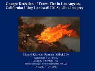
  • 1. Change Detection of Forest Fire in Los Angeles, California; Using Landsat5 TM Satellite Imagery Munshi Khaledur Rahman (KHALED) Department of Geography University of Northern Iowa Remote sensing of the Environment (970:173g) December 16th, 2009
  • 2. Outline  Introduction  Study area and data used  Methodology  Results  Limitation  Conclusion and future direction  References
  • 3. Introduction  Forest fire is a frequent and constant natural disaster in California, USA  The Station Fire (26 August -16 October, 160,577 acres (251 sq mi; 64,983 ha)  209 structures destroyed, including 89 homes  Two firefighters were killed on 30 August  The blaze threatened 12,000 structures in the National Forest and the nearby communities
  • 4. Study Area Figure: Los Angeles, California Forest Fire
  • 5. Data Used  Landsat-5 TM image of October, 2007 and Landsat5 TM image of October, 2009  with 0% cloud  Landsat5Thematic Mapper (TM), from USGS Landsat achieve  5 bands excluding band 6 and band 7.
  • 6. Landsat5 TM Imagery Image 2007, Source: USGS Image 2009, Source: USGS
  • 7. Methodology Figure: Flow chart
  • 8. Methodology continue  Clip target area for before and after fire both the 2007 and 2009 Image  Normalized Difference in Vegetation Index (NDVI)  Supervised Classification  Unsupervised Classification  Extraction of Forest  Change Detection  Final output
  • 9. NDVI For Both Images (2007+2009) Figure: 2007 Image after NDVI Figure: 2009 Image after NDVI
  • 10. Unsupervised Classification  I performed the unsupervised classification classified as 15 classes  Recoded as 4 classes for the image 2009 (after fire) Figure: Unsupervised Classification of 2009 Image
  • 11. Supervised Classification  Supervised Classification for 2007 image only  Took helpe of Unsupervised Class attribute of 2009 Image  Recoded as 3 classes Figure: Supervised classification of 2007 image
  • 12. Perform Change Detection  Change detection is a process that measures how the attributes of a particular area have changed between two or more time periods  Year ‘07 and ’08 extracted forest area as input file Figure: Changedection
  • 13. Result  The Los Angles forest fire has occurred in September, 2009.  Using NDVI clearly showed the real land cover in the Los Angels forest area and showed the areas affected by fire.  Results of image classification and change detection show very clearly the location affected by forest fire  Multi spectral Landsat data can be used for delineating the forest fires
  • 14. Limitations  Multispectral imagery availability and real time data availability  If it is possible then I would like to go to the field and observe the real situation and then can predict the accuracy in full confident  It was hard to differentiate between classification errors and areas of forest spread
  • 15. Conclusions and Future Directions  This project has helped me to learn a lot about image processing, classification of images, extracting target data and information, change detection techniques, and many more  The output of my project shows highly satisfactory result for forest fire change detection but some areas that are identified as growing region in forest fire area which was unexpected  In future, continue my analysis, use accuracy assessment and validation supervised classification for distinguishing urban, forest, different trees species, vegetation, and water bodies in the study area  Burn severity would be really a good thing for analysis
  • 16. Acknowledgement  I would like to thank Sasha for his kind help and guidelines and USGS for providing the Landsat data free.
  • 18. Extraction of forest area  Used Modeler  Extract only forest area  Both before and after forest fire images