Downloaded 13 times

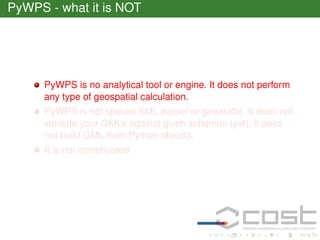


![Talk is cheap. Show me the code
1 from pywps.Process import WPSProcess
2 from osgeo import ogr
3 import types
4 [...]
5
WPSProcess.__init__(self,
6
identifier = "ogrbuffer", # must be same, as filename
7
title="Buffer process using OGR")
8 [...]
9
self.data = self.addComplexInput(identifier = "data")
10
self.size = self.addLiteralInput(identifier="size")
11
self.output =self.addComplexOutput(identifier="buffer")](https://image.slidesharecdn.com/cepicky-pywps-140209142834-phpapp02/85/PyWPS-at-COST-WPS-Workshop-26-320.jpg)
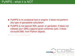
![Talk is cheap. Show me the code
1 from pywps.Process import WPSProcess
2 from osgeo import ogr
3 import types
4 [...]
5
WPSProcess.__init__(self,
6
identifier = "ogrbuffer", # must be same, as filename
7
title="Buffer process using OGR")
8 [...]
9
self.data = self.addComplexInput(identifier = "data")
10
self.size = self.addLiteralInput(identifier="size")
11
self.output =self.addComplexOutput(identifier="buffer")](https://image.slidesharecdn.com/cepicky-pywps-140209142834-phpapp02/85/PyWPS-at-COST-WPS-Workshop-27-320.jpg)
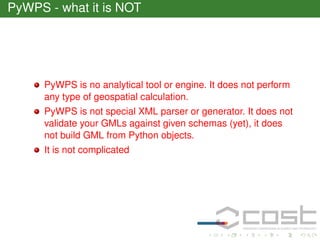
![Talk is cheap. Show me the code
1 from pywps.Process import WPSProcess
2 from osgeo import ogr
3 import types
4 [...]
5
WPSProcess.__init__(self,
6
identifier = "ogrbuffer", # must be same, as filename
7
title="Buffer process using OGR")
8 [...]
9
self.data = self.addComplexInput(identifier = "data")
10
self.size = self.addLiteralInput(identifier="size")
11
self.output =self.addComplexOutput(identifier="buffer")](https://image.slidesharecdn.com/cepicky-pywps-140209142834-phpapp02/85/PyWPS-at-COST-WPS-Workshop-28-320.jpg)
![Talk is cheap. Show me the code
10
11
12
13
14
15
16
17
18
19
20
21
22
23
24
25
26
27
28
29
30
31
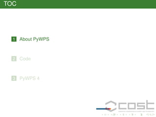
def execute(self):
inSource = ogr.Open(self.data.getValue())
inLayer = inSource.GetLayer()
[...]
outLayer = outSource.CreateLayer(
out,None,ogr.wkbUnknown)
[...]
while index < featureCount:
self.status.set("Calculating buffer for feature %d from %d
(100*(index+1)/featureCount*1.0))
[...]
inGeometry = inFeature.GetGeometryRef()
# make the buffer
buff = inGeometry.Buffer(float(self.size.getValue()))
[...]
self.output.setValue(out)
return](https://image.slidesharecdn.com/cepicky-pywps-140209142834-phpapp02/85/PyWPS-at-COST-WPS-Workshop-29-320.jpg)
![Talk is cheap. Show me the code
10
11
12
13
14
15
16
17
18
19
20
21
22
23
24
25
26
27
28
29
30
31
def execute(self):
inSource = ogr.Open(self.data.getValue())
inLayer = inSource.GetLayer()
[...]
outLayer = outSource.CreateLayer(
out,None,ogr.wkbUnknown)
[...]
while index < featureCount:
self.status.set("Calculating buffer for feature %d from %d
(100*(index+1)/featureCount*1.0))
[...]
inGeometry = inFeature.GetGeometryRef()
# make the buffer
buff = inGeometry.Buffer(float(self.size.getValue()))
[...]
self.output.setValue(out)
return](https://image.slidesharecdn.com/cepicky-pywps-140209142834-phpapp02/85/PyWPS-at-COST-WPS-Workshop-30-320.jpg)

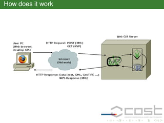
This document provides an overview of PyWPS, an open source Python library for implementing OGC Web Processing Services (WPS). It discusses what PyWPS is and is not, provides code examples of defining and executing a buffer process, and outlines the project's history and future directions. Key points are that PyWPS allows connecting Python and other tools to perform geospatial analyses as WPS processes, is lightweight and modular, and a new version (PyWPS 4) is being developed to improve performance and compatibility.