Case Study_ I69 Expansion Environmental Impacts.doc
•Download as DOC, PDF•
1 like•364 views


Recommended
Recommended
More Related Content
What's hot
What's hot (20)
Viewers also liked
Viewers also liked (20)
Similar to Case Study_ I69 Expansion Environmental Impacts.doc
Similar to Case Study_ I69 Expansion Environmental Impacts.doc (20)
More from Johnny Schaefer
More from Johnny Schaefer (20)
Case Study_ I69 Expansion Environmental Impacts.doc
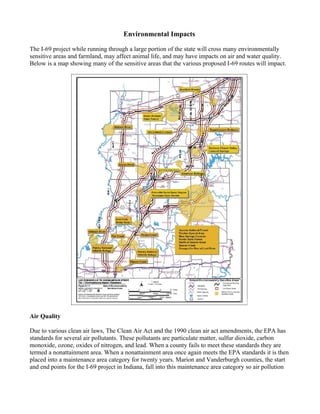
- 1. Environmental Impacts The I-69 project while running through a large portion of the state will cross many environmentally sensitive areas and farmland, may affect animal life, and may have impacts on air and water quality. Below is a map showing many of the sensitive areas that the various proposed I-69 routes will impact. Air Quality Due to various clean air laws, The Clean Air Act and the 1990 clean air act amendments, the EPA has standards for several air pollutants. These pollutants are particulate matter, sulfur dioxide, carbon monoxide, ozone, oxides of nitrogen, and lead. When a county fails to meet these standards they are termed a nonattainment area. When a nonattainment area once again meets the EPA standards it is then placed into a maintenance area category for twenty years. Marion and Vanderburgh counties, the start and end points for the I-69 project in Indiana, fall into this maintenance area category so air pollution
- 2. has to be looked at very carefully. All other counties in the proposed paths of I-69 have been in full compliance with EPA standards. Therefore, the air pollution from the increased vehicle traffic has to be taken into account for the I-69 project. However, it is not just vehicle miles traveled on the road that has to be taken into account but also the grade of the road. Highways will produce more pollutants than a smaller road because of the higher speeds traveled. According to the Environmental Impact Statement, the study was done by the Federal Highway Administration and the Indiana Department of Transportation in 2003, all of the proposed routes for I-69 meet the standards for all of the air pollutants se by the EPA. Endangered Species Taking all of the proposed I-69 routes into concern, there are five endangered and one threatened species in the affected areas, according to the Environmental Impact Statement. The endangered species are the Indiana Bat, American Burying Beetle, Eastern Fanshell Mussel, Fat Pocketbook Mussel, and the Rough Pigtoe Mussel. The threatened specie is the American Bald Eagle. With the preferred path for I-69 chosen by former Governor O’Bannon in 2003, the Indiana Bat, American Bald Eagle, and Eastern Fanshell Mussel would be the only three out of the six affected. Once these species were identified, a more in depth biological assessment was done by the US Forestry and Wildlife Service which determined that none of the three species continued existence would be endangered further. Water Quality There are seven types of natural water features that could possibly be affected by the I-69 project, lakes, streams, sinking basins, sinkholes, public water supplies, public wells, and wellhead protection areas which feed wells. While there should be little to no direct impact on public water supplies, each possible route for I-69 crosses at least a few of the other types of water features. One of the first concerns of the Environmental Impact Statement was road runoff. The reason that this is bad is because of the chemicals used in the salt in the winter time. The melting snow and ice carry these chemicals into the surrounding areas and there are concerns for plant life, soil, water, and animals. After an investigation done by the Federal Highway Administration, it was determined that the runoff from the I-69 project would be within acceptable EPA standards. Another concern is that runoff, chemical spills, and other problems might get into wellhead areas and seep into the aquifers that are used for public water. However, these areas which would be affected by I-69 are already crossed by roadways and so already have emergency response contingencies in place. The emergency response should be able to contain any situations before it gets into the public water supply. Forests Different kinds of ecosystems, such as forest or prairie, can be harmed by roads cutting through them. It may not seem like a road would have a big impact just by going through a forest but it can. Within these ecosystems there is a core and an edge. The core is approximately 100 meters from the outside and the area in between is the edge. A road going through the edge will shrink the core but a road going through the core can completely fracture an ecosystem. The new open spaces caused by the road can allow invasive plan species to enter which choke out the natural areas that were previously there. The
- 3. preferred route for I-69 is estimated to cost 387 acres of core forest according to the Environmental Impact Statement. This amount was average with two other routes costing less and two costing more. These effects have a direct impact on the animals that live in the forests. Often, many animals live in the core of a forest, not the edge. Significant fracturing of the core will have similar significant affects on those animals. Higher amounts of edge areas also increase the number of predators that will further cause population decline. Highways are also barriers to animals that need to travel or migrate to different areas. This can cut animals off from resources that they need or isolate them completely which could lead to population decline or even extinction in small populations. Finally, roads also lead to a higher incidence of death due to being hit by vehicles as well as increased access to hunters. These concerns are very important for conservation of the state’s natural resources. At this point, plans to mitigate the ecosystem impact of I-69 are being considered but the details will not be planned until the next phase of I-69 planning. Farmland There are two types of farmland, prime farmland and non-prime farmland. According to the National Resource Conservation Service which is cited in the Environmental Impact Statement, Indiana is losing prime farmland three to four times faster than the non-prime farmland due to development and urban expansion. The problem becomes that the state is developing mostly on its land best for farming while leaving a lot of the less useful farmland alone. Farming more and more on less productive land is lowering the average returns that farmers are getting from their crops. Prime farmland losses among the various routes being considered range from roughly 2.5 to 4.5 thousand acres. According to the Environmental Impact Statement, the preferred route is estimated to lose a total of 4.3 thousand acres of farmland with 2.9 being prime farmland. This total loss is estimated to cost $1,000,000 in crop production which is above average for the routes. Davies County would be especially hit hard with nearly a third of the cost of crop loss. While these acreages are not a large percent of the state’s farmland, it is not the only development going on in the sate. Additionally, the Farmland Protection Policy Act requires that federal projects take farmland destruction into account in the planning process. The best way to mitigate farmland loss is to try to avoid it completely. In phase 2 planning for the I-69 project, minor realignments are likely such as running the highway along property lines, crossing fields at perpendicular angles, and adjustment of interchange locations in order to try to lessen the affects of the highway on the state’s agriculture. Wetlands According to the Environmental Impact Statement, wetlands only account for 3.5% of Indiana but hold an unusually large amount of plants and animals compared to other environments and a large portion of them are endangered. This makes even a small impact on wetland areas very important because the wildlife and plants are so concentrated in these small areas. Additionally, wetlands can feed aquifers and some areas are important because they act as flood control. There are four major wetland areas within Southwest Indiana as well as several smaller ones. The preferred I-69 route would affect 75 acres of wetlands which is about average for the various routes which affect 20 to 105 acres. Mitigation planning involves bridging through wetlands as well as
- 4. narrowing the construction zone. Additionally, any wetlands affected will be replaced at a ratio of 2:1 or 3:1 depending on what type it is. For the preferred route it is estimated that for the 75 acres taken, 220 will be replaced. Sources: Federal Highway Administration and Indiana Department of Transportation, I-69 Evansville to Indianapolis, Indiana, Tier 1 Final Environmental Impact Statement & Section 4(f) Evaluation, Volume 1, Dec. 2003, http://www.deis.i69indyevn.org/FEIS/Vol1-FEIS/index.html (March - April 2006)