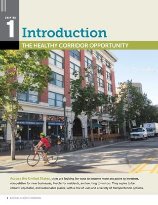
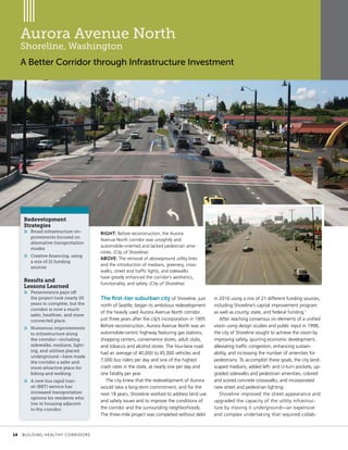
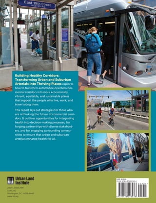
Building Healthy
Places Initiative
BUILDING
THRIVING PLACES
TRANSFORMING URBAN AND SUBURBAN ARTERIALS INTO
HealthyCorridors
BUILDING
THRIVING PLACES
TRANSFORMING URBAN AND SUBURBAN ARTERIALS INTO
HealthyCorridors
Building Healthy
Places Initiative
COVER IMAGES, CLOCKWISE FROM TOP:
A bus rapid transit system in Cleveland has improved connectivity and stimulated development along Euclid Avenue. (Craig Kuhner) |
Safe bicycle infrastructure can decrease injuries and encourage cycling. (Rachel MacCleery) | Wide sidewalks, buffered from travel lanes,
are critical to keep pedestrians, bicyclists, and other users safe. (Craig Kuhner) | Celebrating the culture of the community can help
define an identity for the corridor and attract visitors. (ULI Los Angeles)
© October 2016 by the Urban Land Institute
Printed in the United States of America. All rights reserved.
Recommended bibliographical listing:
Urban Land Institute. Building Healthy Corridors: Transforming Urban and Suburban Arterials into Thriving Places. Washington, D.C.:
Urban Land Institute, 2016.
ISBN: 978-0-87420-393-6
	 ii	 BUILDING HEALTHY CORRIDORS
About the Urban Land Institute
The Urban Land Institute is a nonprofit research and education organization whose mission is to provide
leadership in the responsible use of land and in creating and sustaining thriving communities world-
wide. Established in 1936, the Institute today has more than 39,000 members and associates from
82 countries, representing the entire spectrum of the land use and development disciplines. ULI relies
heavily on the experience of its members. It is through member involvement and information resources
that ULI has been able to set standards of excellence in development practice. The Institute is recognized
internationally as one of America’s most respected and widely quoted sources of objective information
on urban planning, growth, and development.
About the Building Healthy Places Initiative
Around the world, communities are working to become healthier. Through the Building Healthy Places
Initiative, launched in summer 2013, ULI is leveraging the power of its global networks to shape projects
and places in ways that improve the health of people and communities. Learn more about and connect
with the Building Healthy Places Initiative at www.uli.org/health.
About the Rose Center for Public Leadership
in Land Use
The Rose Center for Public Leadership in Land Use encourages and supports excellence in land use
decision making by local governments. A program of the National League of Cities in partnership with
ULI, the Rose Center seeks to foster creative, efficient, practical, and sustainable land use policies by
providing public officials with access to information, best practices, peer networks, and other resources.
The flagship program of the Rose Center is the Daniel Rose Fellowship, which provides city leaders
with the insights, peer-to-peer learning, and analysis they need to improve their cities. The Rose Center
also hosts workshops, forums, and webinars on various aspects of community building in cities across
the country.
About This Report
Building Healthy Corridors: Transforming Urban and Suburban Arterials into Thriving Places explores
strategies for transforming commercial corridors—found in nearly every community across the United
States—into places that support the health of the people who live, work, and travel along them. This
report is the result of a two-year project that involved partnerships with four communities in the United
States that are working to improve a specific corridor in ways that positively affect health. This report
serves as a resource and reference for those who are undertaking corridor redevelopment efforts; it
highlights the importance of health in decision-making processes; and it provides guidance, strategies,
and insights for reworking corridors in health-promoting ways.
ULI is grateful to the Robert Wood Johnson Foundation, the Colorado Health Foundation, and
the ULI Foundation for their support of this project and the Building Healthy Places Initiative.
	 BUILDING HEALTHY CORRIDORS	 iii
ULI Senior Executives
Patrick L. Phillips
Global Chief Executive Officer
Michael Terseck
Chief Financial Officer/
Chief Administrative Officer
Cheryl Cummins
Global Governance Officer
Jeanne R. Myerson
Chief Executive Officer, ULI Americas
Lisette van Doorn
Chief Executive Officer, ULI Europe
John Fitzgerald
Chief Executive Officer, ULI Asia Pacific
Kathleen B. Carey
President and Chief Executive Officer,
ULI Foundation
Adam Smolyar
Chief Marketing and Membership Officer
Steve Ridd
Executive Vice President, Global Business
Operations
Stephanie Wasser
Executive Vice President, Member Networks
Primary Author
Sara Hammerschmidt
Senior Director, Content
Contributing Authors
Aysha Cohen
Senior Associate, Content
Grant Hayes
Research Assistant
Report Staff
Kathleen B. Carey
President and Chief Executive Officer,
ULI Foundation
(as Chief Content Officer)
Rachel MacCleery
Senior Vice President, Content
Jess Zimbabwe
Director of Urban Development,
National League of Cities
Gideon Berger
Program Director, Daniel Rose Fellowship Program,
National League of Cities
Matt Norris
Senior Associate, Content
James A. Mulligan
Senior Editor
Sarah Umberger, Publications Professionals LLC
Manuscript Editor
Betsy Van Buskirk
Creative Director
John Hall Design Group
Designer
Craig Chapman
Senior Director, Publishing Operations
ULI District Council Staff
Rose Faeges-Easton
Senior Director, ULI Nashville
Nashville, Tennessee
Gail Goldberg
Executive Director, ULI Los Angeles
Los Angeles, California
Diane Kushlan
Coordinator, ULI Idaho
Boise, Idaho
Michael Leccese
Executive Director, ULI Colorado
Denver, Colorado
Jonathan Nettler
Senior Director, ULI Los Angeles
Los Angeles, California
	 iv	 BUILDING HEALTHY CORRIDORS
Contents
Introduction
THE HEALTHY CORRIDOR
OPPORTUNITY | 2
1 2
Reinventing Corridors
PROJECT
PROFILES | 10
Getting from Here to There
PLANNING AND IMPLEMENTING
IMPROVEMENTS | 42
4
Building a Healthy Corridor
LESSONS FROM DEMONSTRATION
CORRIDORS | 24
3
References	| 47
Acknowledgments | 50
Across the United States, cities are looking for ways to become more attractive to investors,
competitive for new businesses, livable for residents, and exciting to visitors. They aspire to be
vibrant, equitable, and sustainable places, with a mix of uses and a variety of transportation options.
C H A P T E R
1 THE HEALTHY CORRIDOR OPPORTUNITY
Introduction
	 2	 BUILDING HEALTHY CORRIDORS
OPPOSITE: Using a corridor re-
development approach focused on
health can produce more vibrant,
equitable, sustainable, and attrac-
tive places. (Rachel MacCleery)
LEFT AND ABOVE: Like many
commercial corridors in the United
States, the areas depicted in these
photographs are automobile-
oriented and difficult to
distinguish from each other.
(J.J. Folsom; Andrew Masterpole)
However, nearly every community across the country is challenged by the presence of automobile-
centric commercial corridors. These corridors are characterized by the following:
»» a wide road with multiple lanes;
»» high-speed traffic;
»» nonexistent or limited transit service;
»» buildings separated from the street by large parking lots;
»» unsightly utility poles and wires;
»» a lack of trees and vegetation; and
»» sidewalks that are narrow, in poor condition, interrupted with driveway curb cuts, and unbuffered
from the travel lanes—if they exist at all.
These adverse conditions negatively affect people who live, work, and travel along and rely on
commercial corridors for services and amenities to meet their daily needs. However, corridors are also
essential for local and regional trips and often serve as major connectors. As a result, they often suffer
from high traffic volumes and congestion, which make them unappealing and unsafe for all users,
including drivers.
Redevelopment through infrastructure improvements, new site developments, and aesthetic enhance-
ments has made a difference to the physical conditions along some corridors. The Urban Street Design
	 CHAPTER 1: INTRODUCTION	 3
Commuting percentages by mode
Guide, published in 2013 by the National Association of City Transportation Officials, provides schematics
and strategies for enhancing the design of multiple types of roadways to accommodate a variety of users.
ULI has embarked on many corridor studies over the past two decades as well. Ten Principles for Rein-
venting America’s Suburban Strips, published in 2001, lays out a set of recommendations for reversing
the low-density, automobile-oriented development trends plaguing suburban commercial strips. The ten
principles—which include “ignite leadership and nurture partnership,” “establish pulse nodes of devel-
opment,” and “create the place”—can be applied to urban, suburban, and rural corridors alike.
In addition, more than 12 Technical Assistance Program panels, which are run through ULI’s district
councils, and another 13 urban redevelopment challenges selected by cities participating in the Daniel
Rose Fellowship program (a joint program of ULI and the National League of Cities) have focused on
corridor redevelopment.
64.0%
Car, truck, or van
14.0%
Other
9.9%
Walked
12.1%
Public transportation
85.8%
Car, truck, or van
5.2%
Public transportation
2.8%
Walked0.6%
Biked
5.6%
Other
Sources: U.S. Census Bureau, Decennial Census for 1960 and American Community Survey for 2013.
1960 2013
	 4	 BUILDING HEALTHY CORRIDORS
Although reinventing the street, sidewalk, and adjacent properties along corridors has received a lot
of attention, less consideration has been paid to restructuring the corridors—in conjunction with im-
proving access from nearby neighborhoods—in ways that might improve health outcomes for residents,
workers, and visitors. The rise of chronic diseases such as obesity, heart disease, diabetes, and asthma
that are partially attributable to the built environment, as well as the rise of injury rates for pedestrians
and bicyclists, points to the need to look more holistically at how corridor redevelopment can create the
opportunity to foster healthier behavior and lifestyles.
Over the past several decades, commuting and other trips by car have increased, while walking,
biking, and public transit use have decreased overall. The percentage of work trips taken by automobile
has increased from 64 percent in 1960 to nearly 90 percent in 2013, although bike commuting (still
a small fraction compared with commuting by car) is currently the fastest-growing mode of travel to
work. Conversely, the percentage of school-aged children who walked or biked to school decreased
from 40 percent in 1969 to just 13 percent in 2009. The design of the built environment has contrib-
uted to those trends.
From a safety perspective, people may feel safer as drivers or passengers inside vehicles than as
pedestrians or cyclists—and with good reason, particularly on streets without sidewalks or bike lanes.
Pedestrians on streets without sidewalks are 200 percent more likely to be involved in crashes than
pedestrians on streets with sidewalks. Vehicle speeds contribute to fatalities: for pedestrians, the
average risk of death increases as speed increases, from 10 percent at an impact speed of 23 miles per
hour to 50 percent at 42 miles per hour. Measures that slow vehicle speed can reduce the number of au-
tomobile crashes that cause injuries by 10 percent on main roads and by 25 percent on residential streets.
Just as urban waterfront redevelopment capitalizes on public space in cities, commercial corridors
should be considered assets that can be redeveloped to support civic life, enhance economic develop-
ment, and serve as neighborhood resources.
The American public wants redevelopment that promotes healthier living. Fifty percent of those sur-
veyed by ULI in 2015 reported that walkability is a priority when considering where to live. Similarly, 52
percent would like to live in a place where they do not have to use a car very often.
ABOVE: Typical land uses along
commercial corridors include
used-car lots, fast-food restau-
rants, and other uses that do not
serve the daily needs of residents.
(Guy Hand)
OPPOSITE: Poorly maintained
sidewalks coupled with undesir-
able land uses discourage pedestri-
an activity and incentivize driving.
(Courtesy of Sasaki)
	 CHAPTER 1: INTRODUCTION	 5
Automobile-centric corridors often divide neighborhoods and interrupt social cohesion because they
are unsafe to cross. The neighborhoods most affected tend to be lower-income neighborhoods whose
residents are not well served by the plethora of car sales lots and fast-food restaurants lining these corri-
dors. In addition, certain corridor land uses, such as gas stations, may cause environmental problems.
These complex issues need to be addressed by engaging residents and advocacy groups to identify
the economic and environmental problems along corridors; an improvement plan can then be formu-
lated to benefit all. Creating corridors that support a variety of daily needs—such as allowing people to
walk or bike safely to purchase groceries, run other errands, or exercise—is critical to creating a healthy
community.
The Healthy Corridors Approach
Corridor redevelopment is not a new topic. Various planning and design approaches—such as complete
streets, living streets, and great streets—aim to redevelop commercial corridors to meet more of their
users’ needs, including their need for walking and biking rather than just traveling by car. But a marked
difference between a healthy corridors approach and other approaches is that the former considers how
the street supports the daily needs and affects the health of all who live, work, and travel along it.
The healthy corridors approach considers how the corridor contributes to the overall health of
the surrounding community, including supplying opportunities to be physically active. It also considers
safety, housing affordability, transportation options, environmental sustainability, and social cohesion,
as well as modifications that would link residents to the corridor and improve connections to jobs and
other parts of the community.
Understanding a wide range of baseline factors, including the demographics of communities sur-
rounding the corridor, current transit access, market conditions, types of land uses and businesses, and
community needs and interests—as well as sidewalk, travel lane, intersection, and other infrastructure
conditions—is the foundation of this approach.
BELOW: St. Paul, Minnesota’s HIA
made community members and
health outcomes a part of
the city’s rezoning discussion.
(runner1928/Wikimedia Commons)
OPPOSITE: The healthy corridors
approach considers the needs of
all types of users. (Craig Kuhner)
	 6	 BUILDING HEALTHY CORRIDORS
The healthy corridors approach takes into account the needs of surrounding neighborhoods. Doing
so is particularly important if the surrounding neighborhoods contain residents who are low-income or
excluded from decision-making processes.
A process that can foster the incorporation of both health and equity into community planning and
engagement efforts is a Health Impact Assessment (HIA). In Minnesota, the city of St. Paul used an HIA
when developing a new plan for the area around University Avenue; the plan incorporated a new rail
line connecting the downtowns of Minneapolis and St. Paul. Through the HIA process, which was led by
health- and equity-focused community organizations, community members of the racially and ethnically
diverse high-poverty area became engaged in the city’s rezoning process.
Those who examine commercial corridors often see that roads need to be reconfigured to improve
pedestrian, bicyclist, and vehicle safety; but to create a complete revitalization plan, they must also
consider people-focused outcomes other than safety. Using health as the defining criterion for corridor
redevelopment—or for any type of land use project—can provide a new way of looking at problems and
potential solutions. The health lens allows diverse stakeholders, such as public health professionals, local
hospital systems, and health-focused nonprofits and foundations, to engage in the process.
By broadening the conversation and the focus to include not only an emphasis on pedestrian and bi-
cyclist safety but also on access to healthy food, physical activity opportunities, economic opportunities,
enhanced connections to other parts of the city, and a variety of housing options, local governments,
businesses, residents, and other stakeholders can create a more holistically healthy corridor. To ensure
that improvements will benefit everyone, it is also critical to prevent resident displacement by retaining
and providing affordable housing, including market-rate affordable housing, and by developing strate-
gies to retain local businesses. Engaging a wide spectrum of stakeholders—including residents, advoca-
cy organizations, and social justice groups—around the concept of healthy corridor redevelopment can
help embed a culture of health within the community and beyond.
Health
Impact
Assessments
A Health Impact Assess-
ment (HIA) is an evidence-
based process that en-
gages the community,
gathers health-related
information, and identi-
fies strategies to improve
community and indivi-
dual health. Used to
identify potential health
impacts of projects, plans,
and policies, HIAs consist
of six phases typically
used in other types of im-
pact assessment: screen-
ing, scoping, assessment,
recommendations, report-
ing, and evaluation and
monitoring.
	 CHAPTER 1: INTRODUCTION	 7
Healthy Corridor Typology
A primary activity of ULI’s Healthy Corridors project was to define a healthy corridor and identify the components that
make up a holistically healthy corridor and its surrounding area. A healthy corridor has land uses and services that allow
residents and visitors to make healthy lifestyle choices more easily. A healthy corridor is a place that reflects the culture of
the community, promotes social cohesion, inspires and facilitates healthy eating and active living, provides and connects to
a variety of economic and educational opportunities and housing and transportation choices, and adapts to the needs and
concerns of residents.
Improved
infrastructure
»» Frequent, safe, and well-marked pedestrian crossings
»» Safe and well-marked bike lanes
»» Traffic speeds that accommodate pedestrians, bicyclists, and other users
»» Reduced traffic congestion
»» Utility lines and traffic signs and signals that are underground or that blend in
»» Sidewalks that link adjacent neighborhoods to the corridor and that are unobstructed, wide
enough for a variety of users, and buffered from the street
»» Streetscapes that include amenities for visual interest and safety, including seating, trees for
shade, and green buffers
»» Lighting that improves visibility and safety for pedestrians and bicyclists
»» Features that improve accessibility for all types of users, in compliance with Americans with
Disabilities Act standards
Design and land
use patterns
that support
community needs
»» Vibrant retail environment
»» Housing options for all income levels
»» Buildings adjacent or proximate to sidewalks
»» Improved parking strategies and shared parking
»» High-quality parks and public spaces
»» Healthy food options
Engaged and
supported people
who live, work,
and travel along
the corridor
»» Engaged residents and local business owners
»» Organizations that facilitate long-term improvements and resident engagement
»» Regular programs in community gathering spaces
»» Accommodations for pets
»» Accommodations for vulnerable populations, including children, the elderly, and people with
disabilities
»» A defined identity, drawing on the arts and culture of the community and supported by creative
placemaking programming
»» Measures to address safety and perceptions of safety
Linkages to other
parts of the city
»» Well-connected, multimodal street networks
»» Safe and easily identifiable connections, including sidewalks and trails
»» Transit, including enhanced bus service or rail
»» Bike infrastructure on or adjacent to the corridor
	 8	 BUILDING HEALTHY CORRIDORS
Report Overview
Through strong partnerships among both typical and new stakeholders, corridors across the United
States can be redeveloped in ways that create healthier conditions for those who live, work, and travel
along them. Through corridor revitalization that is focused on health, communities can become more
economically vibrant, equitable, sustainable, and attractive places. The healthy corridors approach helps
all involved in corridor redevelopment and community revitalization—the public sector, the private sec-
tor, nonprofits, and neighborhood advocacy groups—work together to create a better future.
This summary report presents the results of ULI’s two-year Healthy Corridors project, which was un-
dertaken in partnership with the ULI district councils and stakeholders of four corridors in four cities in
different parts of the country—Federal Boulevard in Denver, Colorado; Vista Avenue in Boise, Idaho; Van
Nuys Boulevard in Los Angeles, California; and Charlotte Avenue in Nashville, Tennessee. Together, these
constitute the project’s “demonstration corridors.” This report is intended to serve as a resource and
reference for those who are undertaking corridor redevelopment projects; it highlights the importance
of including health factors in decision-making processes, and it provides guidance on how to prioritize
the health of those who live, work, and travel along these corridors.
Building on previous ULI Building Healthy Places Initiative publications—including Ten Principles for
Building Healthy Places, Building Healthy Places Toolkit: Strategies for Enhancing Health in the Built
Environment, and Active Transportation and Real Estate: The Next Frontier—this report provides a foun-
dation for the real estate and land use communities to understand how to design and construct projects
focused on health.
Partnerships are necessary to solve problems within commercial corridors; therefore, this report is
targeted to a variety of audiences, including real estate developers, community planners, public and
elected officials, public health professionals, transportation professionals, nonprofit leaders, and
community decision makers.
This report defines what constitutes a healthy corridor, shares a healthy corridor typology, explores
case studies from corridor redevelopment projects across the United States, and summarizes lessons
from the project’s demonstration corridors. It uses findings to demonstrate specific aspects of a healthy
corridor and to outline a process roadmap for transforming commercial corridors into healthier places.
Other helpful materials developed as a part of this project—including sample workshop agendas,
a Healthy Corridor Audit Tool, and a resource and strategy guide for corridor redevelopment—can be
found at uli.org/healthycorridors.
LEFT: Engagement strategies such
as dot voting can be valuable plan-
ning tools, allowing project leaders
to gain valuable insight from
community stakeholders. (Rachel
MacCleery)
OPPOSITE: A healthy corridor has
engaged and supported residents
and visitors; programs in public
spaces contribute to community
engagement. (Martha Cooper)
	 CHAPTER 1: INTRODUCTION	 9
Over the course of the Healthy Corridors project, ULI worked with four corridors to
imagine a healthier future. ULI also researched successful corridor redevelopment efforts across
the country.
To help determine how to redevelop corridors in ways that promote health, four ULI district councils
that were selected through a competitive application process identified problematic corridor sections
to study over the course of the Healthy Corridors project, from late 2014 through 2016. These corridor
sections served as demonstration corridors for the project. ULI also profiled commercial corridors from
across the country—corridors that worked to reinvent themselves.
C H A P T E R
2 PROJECT PROFILES
ABOVE: A healthy corridor has
improved infrastructure, such as
safe and well-marked bike lanes.
(Elvert Barnes/flickr)
Reinventing
Corridors
	 10	 BUILDING HEALTHY CORRIDORS
Reimagining Corridors for the Better
Discussing commercial corridors in the context of public health is a new approach that requires new
partnerships and a new way of looking at corridor redevelopment, one that goes beyond economic
development opportunities or complete streets. Although there may not yet be an example of a rede-
veloped corridor that is holistically healthy—that is, a corridor characterized by improved infrastructure;
design and land use patterns that support community needs; engaged and supported people who live,
work, and travel along the corridor; and linkages to other parts of the city—many cities have successfully
implemented components of this healthy corridor typology in an effort to create better corridors.
The following case studies of redeveloped corridors across the United States outline the completed
processes and projects that leveraged transportation, design, zoning, community engagement, health,
public art, or a combination of these components, to transform corridors and improve conditions for all.
The case studies are intended to inspire changes that positively affect health in other corridors across
the country, including ULI’s demonstration corridors. They show how improvements in infrastructure,
housing, sustainability, and cultural amenities along commercial corridors can contribute to creating
more vibrant, livable, and healthier places.
The four demonstration corridors participating in ULI’s Healthy Corridors project—Federal Boulevard
in Denver, Colorado; Vista Avenue in Boise, Idaho; Van Nuys Boulevard in Los Angeles, California; and
Charlotte Avenue in Nashville, Tennessee—are striving to become healthy corridors. Their stakeholders
are adopting many healthy corridor characteristics in their redevelopment goals, processes, and plans,
all of which are designed to consider health in a comprehensive way. These are discussed further in
Chapter 3.
Further information and resources regarding the strategies undertaken by the cities highlighted in the
following case studies—and the strategies planned by the demonstration corridors—are explored in the
companion piece, “Building Healthy Corridors: Strategy and Resource Guide,” which can be downloaded
at uli.org/healthycorridors.
Strategy and
Resource
Guide
A companion piece to this
report, the “Strategy and
Resource Guide,” provides
a menu of opportunities
for focusing on health
within redevelopment
efforts. The guide is
intended to serve as a
resource for communities
interested in redeveloping
commercial strip corri-
dors in partnership with
regional and community
stakeholders. To download
the guide, visit uli.org/
healthycorridors.
Many communities have integrated
elements of a healthy corridor
into their redevelopment plans.
(Craig Kuhner)
	 CHAPTER 2: REINVENTING CORRIDORS	 11
Columbia Pike
Arlington County, Virginia
Using Form-Based Codes to Improve Design and Land Use Patterns
LEFT: Before, Columbia Pike had narrow
sidewalks and an automobile-oriented
streetscape. (Arlington County)
ABOVE: A form-based code has helped
transform Columbia Pike into a safer
and more pedestrian-friendly arterial.
(Arlington County)
Redevelopment
Strategies
»» Form-based codes (FBCs)
»» Tax increment financing
Results and
Lessons Learned
»» Although implement-
ing an FBC is a lengthy
process, it can help
incentivize developers
to redevelop in ways that
improve the streetscape,
density, and land uses of
a corridor.
»» In Arlington County,
the use of FBCs has
been instrumental both
in preserving existing
affordable housing and in
encouraging new afford-
able housing.
»» Other critical infra-
structure improvements
include utilities moved
underground; relocated
parking, bike, and pedes-
trian amenities; and
enhanced transit services.
Located outside Washington, D.C., in
Arlington County, Virginia, Columbia Pike is a
thoroughfare stretching more than three miles—
from the edge of the Pentagon to the border of
Fairfax County. The road was built in 1810 to
connect Washington’s Long Bridge to the Little
River Turnpike and the rest of Virginia. It evolved
to become an automobile-oriented arterial—lined
with fast-food restaurants, drive-through restau-
rants and banks, convenience stores, and strip
malls—characterized by intense traffic congestion.
Arlington County sought to alleviate the
congestion through the Columbia Pike Initiative,
a corridor revitalization plan focused on the
commercial corridors and adopted in 2002. The
initiative was organized around an innovative
Commercial Centers Form-Based Code (FBC) and
supportive government-led programs, including
a partnership with D.C.’s Metrobus. In 2008, the
Arlington County Board issued a charge to begin
work on Phase II of the Columbia Pike Initiative,
which focused on multifamily residential areas
located between the commercial centers. Phase II
culminated in the adoption of the Neighborhoods
Area Plan in 2012, which outlined the goals and
tools that could be used to create the transporta-
tion, form, and housing vision for the multifamily
areas. In 2013, the Columbia Pike Neighborhoods
Form-Based Code (NFBC) was adopted in support
of this vision. Together, the plans and the two
codes work to create more urban parks and
affordable housing, promote a safe biking and
walking environment, and improve the corridor’s
transit options.
The two form-based codes were designed to
kick-start development along Columbia Pike. The
preapproved standards act as an incentive for
developers because they allow for a much faster
approval process, saving developers both time and
money. Developers who choose to use the FBCs
	 12	 BUILDING HEALTHY CORRIDORS
can get project approvals typically within six to
nine months with only one or two public hearings,
whereas the conventional process can take nine
to 12 months or even longer. Each code includes
a process for administrative approval by the
zoning administrator for smaller and less complex
projects.
Within the FBCs are prescriptions for street
planning and standards for building envelopes,
streetscapes, and architecture. In the Commer-
cial Centers FBC, buildings are required to have
street frontage, first-floor retail space, and built-in
bicycle amenities.
Affordable housing development is incentivized
through the NFBC, which requires that 20 to 35
percent of net new units in developments be afford-
able to residents with incomes of up to 60 percent
of the area median income for a period of 30 years.
To help meet the ambitious affordable hous-
ing goal, the county also employed financial
tools. The Transit-Oriented Affordable Housing
(TOAH) Fund was adopted by the county in 2013.
Affordable housing developers who apply for
low-income housing tax credits may put TOAH
funds toward infrastructure-related items (such
as underground utilities, tree preservation, and
streetscape improvements) and county fees (such
as a certificate of occupancy, building permits, and
utility fees) to help keep project costs under the
Virginia Housing and Development Authority total
development cost limits and increase competitive-
ness for tax credits.
The Columbia Pike Tax Increment Financing (TIF)
Area was established as a funding mechanism for
the TOAH. The Columbia Pike TIF dedicates 25
percent of incremental new tax revenue generated
by new development and property appreciation
within specifically designated commercial and
multifamily residential revitalization districts to 
affordable housing along the corridor.
Arlington County’s commitment to affordable
housing has been enhanced through the NFBC.
Other tools such as the Affordable Housing
Investment Fund (AHIF) and low-income housing
tax credits have helped with the preservation and
creation of new units. The county has preserved or
created 938 affordable units along the Pike since
2012. These units were preserved or created using
AHIF, public/private partnerships, or the affordable
housing requirements under the NFBC. Of the total
938 affordable units, 499 were preserved in the
existing buildings with assistance from AHIF loans
or the NFBC affordable housing requirements.
Because of the FBCs and programming planned
by Arlington County, Columbia Pike now has
elements that make it a healthier and more
pedestrian-friendly area. Since the FBC’s adoption,
the corridor has added more than 1 million square
feet of commercial space, a new community
center, a weekly farmers market, a supermarket,
about 3,000 residential units, and multiple open
spaces that complement a nearby 45-mile paved
walking, running, and bike trail. The county is
building new bike and pedestrian infrastructure,
and the FBC mandates that all parking must be
behind or underneath buildings to preserve and
enhance the streetscape. As a requirement of
the code, any redevelopment project must also
finance the burial of utilities on that block.
Columbia Pike is now the busiest bus transit
corridor in Virginia, with bus lines that have in-
creased ridership and frequency and that connect
to the Pentagon Metro station. The corridor also
features two walking loops, “bike boulevards”
on adjacent streets, bike racks, and six Capital
Bikeshare stations.
Form-Based
Codes
A form-based code (FBC)
is a regulation, not a
guideline. As such, it is a
means of regulating land
development to achieve a
specific urban form and
to create a destination in
an area. Unlike traditional
zoning, which is based on
separation of uses, FBCs
use physical form as the
organizing principle of
design and development
to create a high-quality
public realm. An FBC is
adopted into city, town,
or county law and is a
powerful alternative to
conventional zoning
regulations. Benefits to
developers include faster-
than-normal approval of
their plans, a lower risk
of residents opposing the
project, and a potential for
increasing the density of
the project.
LEFT: Before the form-based
code, strip malls and other de-
velopments along Columbia Pike
catered to drivers. (Courtesy of
BM Smith).
BELOW: Parking relocated from
the front to the back of devel-
opments helps create a better
environment for pedestrians and
bicyclists. (Arlington County)
Project
Location
Topic Head
Aurora Avenue North
Shoreline, Washington
A Better Corridor through Infrastructure Investment
RIGHT: Before reconstruction, the Aurora
Avenue North corridor was unsightly and
automobile-oriented and lacked pedestrian ame-
nities. (City of Shoreline)
ABOVE: The removal of aboveground utility lines
and the introduction of medians, greenery, cross-
walks, street and traffic lights, and sidewalks
have greatly enhanced the corridor’s aesthetics,
functionality, and safety. (City of Shoreline)
in 2016 using a mix of 21 different funding sources,
including Shoreline’s capital improvement program
as well as county, state, and federal funding.1
After reaching consensus on elements of a unified
vision using design studies and public input in 1998,
the city of Shoreline sought to achieve the vision by
improving safety, spurring economic development,
alleviating traffic congestion, enhancing sustain-
ability, and increasing the number of amenities for
pedestrians. To accomplish these goals, the city land-
scaped medians, added left- and U-turn pockets, up-
graded sidewalks and pedestrian amenities, colored
and scored concrete crosswalks, and incorporated
new street and pedestrian lighting.
Shoreline improved the street appearance and
upgraded the capacity of the utility infrastruc-
ture by moving it underground—an expensive
and complex undertaking that required collab-
The first-tier suburban city of Shoreline, just
north of Seattle, began its ambitious redevelopment
of the heavily used Aurora Avenue North corridor
just three years after the city’s incorporation in 1995.
Before reconstruction, Aurora Avenue North was an
automobile-centric highway featuring gas stations,
shopping centers, convenience stores, adult clubs,
and tobacco and alcohol stores. The four-lane road
had an average of 40,000 to 45,000 vehicles and
7,000 bus riders per day and one of the highest
crash rates in the state, at nearly one per day and
one fatality per year.
The city knew that the redevelopment of Aurora
would take a long-term commitment, and for the
next 18 years, Shoreline worked to address land use
and safety issues and to improve the conditions of
the corridor and the surrounding neighborhoods.
The three-mile project was completed without debt
Redevelopment
Strategies
»» Broad infrastructure im-
provements focused on
alternative transportation
modes
»» Creative financing, using
a mix of 21 funding
sources
Results and
Lessons Learned
»» Perseverance pays off:
the project took nearly 20
years to complete, but the
corridor is now a much
safer, healthier, and more
connected place.
»» Numerous improvements
to infrastructure along
the corridor—including
sidewalks, medians, light-
ing, and utilities placed
underground—have made
the corridor a safer and
more attractive place for
biking and walking.
»» A new bus rapid tran-
sit (BRT) service has
increased transportation
options for residents who
live in housing adjacent
to the corridor.
	 14	 BUILDING HEALTHY CORRIDORS
oration with many partners. The city installed
sustainable stormwater features and living
retaining walls and developed a rainwater filtra-
tion plaza for pedestrians.
As part of the project, Shoreline improved
its three-mile section of the Interurban Trail—a
24-mile trail connecting the cities of Seattle and
Everett—to make it a seamless cycling trail with
iconic bridge crossings over Aurora Avenue North
and North 155th Street.
To improve transit options, a new dedicated bus
rapid transit (BRT) service called RapidRide, the fifth
of six county BRT lines, was developed with the help
of state and federal resources in partnership with the
King County Department of Transportation’s Metro
Transit division and the city of Seattle. To support the
service, Shoreline established what it calls “business-
access transit lanes,” which support access to busi-
nesses and also provide stopping spaces for buses;
installed an intelligent fiber-based transportation
system to enable buses to communicate with traffic
signals; and incorporated preboarding payment
stations. The prepayment system allows riders to
quickly board the buses, which feature low floors,
three doors, and “next stop” displays and audio. The
corridor’s improved bus stops feature electronic next-
arrival signs, weather protection coverings, and interi-
or and exterior lighting to improve bus stop visibility.
Since the construction project began in 2005,
Shoreline has begun to experience returns on the
$146-million investment. Before the project was
even complete, crashes declined by 60 percent.
Since 2015, Shoreline’s Aurora Avenue North has
welcomed multiple new businesses and community
services: two health clinics, a YMCA, a biotech
lab, a Trader Joe’s, the City Hall, and a high school.
Seven hundred completed housing units span the
affordability range, with another 1,000 units either
under construction or in the permitting process.
In addition, the Puget Sound Regional Coun-
cil, the region’s planning agency, gave the city
its Vision 2020 Award, and the Federal Highway
Administration and the Washington State Depart-
ment of Transportation presented the city with a
2008 Award of Excellence for Best City Project.
Aurora Avenue North is now Shoreline’s main
street. It is aesthetically pleasing, safer, more effi-
cient, and optimized for new economic develop-
ment. The project has improved pedestrian safety,
automobile capacity, transit performance, traffic
flow, and stormwater management. The BRT is
expected to save motorists between $2,000 and
$8,000 a year, and, since launching in 2014, bus
reliability has improved and weekly ridership has
increased by 13 percent. Local leaders foresee that
the city’s investment will encourage local land-
owners to redevelop their properties along Aurora
and that additional redevelopment could further
enhance the corridor for all users.
1
For the last stretch of corridor
improvements, funding sources
included the Federal Highway
Administration, Washington State
Transportation Improvement Board,
Washington State Department of
Transportation Regional Mobility
grants, Washington State Depart-
ment of Ecology, King County
Metro, Seattle City Light, Seattle
Public Utilities, Ronald Wastewater
District, and the city of Shoreline.
LEFT: Shoreline’s corridor im-
provements include the addition
of a bridge to improve connec-
tions along the Interurban Trail, a
24-mile cycling trail between the
cities of Seattle and Everett. (HDR
Engineering Inc.)
BELOW RIGHT: Previously, little
emphasis was placed on bus ac-
cessibility and passenger comfort
along the Aurora corridor. (City of
Shoreline)
BELOW LEFT: Now, dedicated bus
lanes, covered and prominent bus
stops, and other bus infrastructure
improvements have helped im-
prove BRT reliability and ridership
along the Aurora corridor. (City of
Shoreline)
	 CHAPTER 2: REINVENTING CORRIDORS	 15
Euclid Avenue
Cleveland, Ohio
Enhancing a Corridor through Transit Investment
Euclid Avenue in Cleveland is celebrated in
the city’s history as the turn-of-the-20th-century
home to John D. Rockefeller and other prominent
American businessmen. However, as development
pressure and Cleveland’s population increased,
Euclid Avenue’s luxury homes gave way to parking
lots and shopping centers.
Beginning in the 1970s, local leaders set out to
reestablish the corridor as a major transportation
and economic development link by implementing
a new transit system along the avenue. Seeking
to connect the city’s two largest commercial
districts—downtown and University Circle—
Cleveland stakeholders voted to establish a bus
rapid transit (BRT) system in 1998. Known as the
HealthLine, the BRT has both improved connec-
tivity and attracted new development to the area
since its completion in 2008.
In strategic partnerships with state and federal
agencies, local stakeholders—including the city of
Cleveland, the Cleveland Clinic, University Hospi-
tals, and the Greater Cleveland Regional Transit
Authority (Cleveland’s regional planning agency)—
completed the project for a total investment cost
of $200 million. The three goals guiding the devel-
opment were to (1) improve service and efficiency
for customers, (2) promote economic and commu-
nity development along and adjacent to the line,
and (3) improve quality of life for residents and
visitors of the corridor and for area employees.
Today, the 9.2-mile HealthLine services Cleve-
land’s cultural amenities, businesses, medical
centers, and the convention center while oper-
ating seven days a week, 24 hours a day, along
dedicated bus lanes. HealthLine buses and stations
are highly efficient because the hybrid vehicles
contain GPS communication, multiple doors for
boarding, and text and audio communications.
The stops feature raised platforms, fare vending
machines, station signage, real-time displays, and
interactive kiosks.
In anticipation of increased growth along the
corridor, $10 million of the total investment was
put toward improving sidewalks, bike lanes, and
the utility infrastructure. Design improvements
along the corridor include lighting, public art,
Redevelopment
Strategies
»» Broad infrastructure
improvements centered
around transit
»» Public/private partner-
ships to fund and imple-
ment the project
Results and
Lessons Learned
»» Strong public/private
partnerships between
multiple stakeholders
contributed to the suc-
cess of the project.
»» The establishment of a
new transit line resulted
in $6.3 billion in new
development, 13,000 new
jobs, and more than 4,000
new residential units
along the corridor.
	 16	 BUILDING HEALTHY CORRIDORS
OPPOSITE: A new BRT system
has helped reestablish Euclid
Avenue as a major transporta-
tion corridor in Cleveland. (Craig
Kuhner)
ABOVE RIGHT: Before, Euclid
Avenue was a desolate, car-
oriented corridor that lacked pub-
lic and private investment. (Jason
Hellendrung)
ABOVE LEFT AND BELOW:
Now, Euclid Avenue operates as a
complete and scenic street. (Craig
Kuhner)
newly paved surfaces, and 1,500 trees. Adjacent
neighborhoods were given distinct identities
through varying tree species, lighting patterns,
and pavement and bus shelter designs.
Since the HealthLine’s completion, new devel-
opment and increased stakeholder collaboration
have greatly improved the aesthetics and the
usability of Euclid Avenue. Transit travel times
have been reduced from 40 to 28 minutes. In the
first year of operation, ridership increased by 48
percent, and between 2008 and 2015, ridership
increased 70 percent.
The HealthLine has been credited with having
the highest return on investment of any recent
U.S. transit project, with $6.3 billion in develop-
ment along the line, 13,000 new jobs, and more
than 4,000 new residential units. The hybrid buses
have 75 percent better fuel economy, and the new
trees are expected to absorb close to 48 pounds
of carbon dioxide per year once they reach matu-
rity. After the BRT was completed, travel between
destinations along Euclid Avenue became quicker
for those traveling by bus or car and safer for
those traveling by foot or bike.
Those accomplishments earned the HealthLine
the Grand Award from the American Council
of Engineering Companies in 2010, the Global
Award for Excellence from ULI in 2011, and the
title “Best in North America” by the Institute for
Transportation and Development Policy in 2013.
	 CHAPTER 2: REINVENTING CORRIDORS	 17
Short North Arts District
Columbus, Ohio
A New Hub for Arts and Culture
The Short North Arts District, which is
centered on High Street, consists of 14 blocks
north of downtown Columbus just south of
the Ohio State University campus. Once home
to neglected buildings, boarded-up windows,
and few businesses—and visited frequently by
the police—the area once known as the “Near
Northside” became known as “Short North” after
the Columbus police gave the area that moniker
for being just short of the northern boundary of
the downtown precinct. Short North underwent a
makeover when local artists, historic preservation-
ists, and small businesses began to transform the
area into an arts district in the 1980s.
In 1983, the Short North Business Association
was founded to access funding and develop the
area into a thriving community. One year later, a
group of area gallery owners created the Gal-
lery Hop, a monthly event to showcase new art
exhibits. That move brought an influx of visitors,
residents, and businesses to the area.
Redevelopment
Strategies
»» Special improvement
district (SID), funded
through property
assessments of corridor
businesses
»» A defined identity cen-
tered around arts and
culture
Results and
Lessons Learned
»» Local business owners
initiated the redevelop-
ment effort and created
a business association to
spearhead the transfor-
mation of the corridor.
»» Regular community
programs and an
emphasis on arts and
culture brought renewed
attention and visitors to
a formerly neglected and
unsafe area.
	 18	 BUILDING HEALTHY CORRIDORS
By the late 1980s, a group of local residents
created a satirical and countercultural annual July
Fourth event now known as the Doo Dah Parade.
Thirty years later, programming continues and
consists of many events concentrated on or near
High Street, including the street concert and fash-
ion show “HighBall Halloween”; a weekend-long
concert titled the “Community Festival,” which
features local bands; and the Stonewall Columbus
Pride Parade.
In 1999, the Short North Special Improvement
District (SID) was created by community leaders to
enhance the safety, cleanliness, and beauty of the
Short North Arts District. The organization is funded
through the collection of property assessments
from district businesses, and that funding enables
the organization to provide services and public
improvements.
In 2012, the Short North Business Association
merged with the Short North SID to form the Short
North Alliance (SNA), which is contracted annually
by the SID. The SNA works to continue the Short
North Arts District’s development as a vibrant, cre-
ative, and inclusive community and arts destination
while maintaining the area’s position as “the art
and soul of Columbus.” To accomplish these goals,
the SNA has continued to market the area and to
serve property and business owners while main-
taining the management and scheduling of events.
As programming and an organizational struc-
ture have come together, the Short North Arts
District’s community health and social connect-
edness have greatly improved. Today, the Gallery
Hop includes restaurants, galleries, and shops,
and it attracts more than 25,000 attendees a year.
More than 30,000 people participate in HighBall,
an estimated 80,000 attend the Community
Festival, about 500,000 spectators watch the Pride
Parade, and the Doo Dah Parade has become
locally renowned. Through the SID, Columbus’s
tradition of illuminated arches was restored with
the installation of 17 steel arches that create an
identity for the district.
Those improvements have gained much nation-
al attention: the Short North Arts District has been
recognized by the New York Times, USA Today,
Fox News, and various other media outlets. More-
over, 34 new businesses opened in 2015, and 2.5
million people visited the community the same
year. By bringing a variety of groups together,
the Short North Arts District has become a more
vibrant and livable community.
OPPOSITE TOP: The Short North
Arts District has been nationally
recognized for its infrastructure
and programming improvements.
(Bailey Lytle, Short North Alliance)
OPPOSITE INSET: Short North’s
identity has been restored and its
social capital boosted by the in-
troduction of programming and a
business association. (Bailey Lytle,
Short North Alliance)
ABOVE: Once known for its
crime, Columbus’s Short North
neighborhood has become a
popular cultural destination that
attracts over 2 million diverse visi-
tors. (Top: Bailey Lytle, Short North
Alliance. Inset: Dana Bernstein,
Short North Alliance)
	 CHAPTER 2: REINVENTING CORRIDORS	 19
Edgewater Drive
Orlando, Florida
A Safer Street through Lane Reduction
Streets have played a major role in the
development of College Park, a neighborhood ad-
jacent to downtown Orlando, Florida. The neigh-
borhood’s Princeton, Harvard, and Yale streets
influenced the naming of the city’s first subdivision
and eventually the naming of the neighborhood.
Beginning in 1999, local stakeholders gave
College Park a new identity by transforming Edge-
water Drive, its main street. The four-lane road
was extremely unsafe; it carried more than 20,000
speeding motorists per day, and it experienced
crashes nearly every three days and injuries every
nine days. Because the road also contained limited
space for sidewalks, bike lanes, and streetscape,
the city of Orlando implemented a lane reduc-
tion—or “road diet”—to regain space for pedes-
trians and bicyclists.
Since the project’s implementation, Edgewater
Drive has become a noticeably healthier and safer
street. Traffic speeds and the number of crashes
have been reduced, and both the volume and satis-
faction of pedestrians and bicyclists have increased.
The project emerged from a neighborhood
improvement plan called the Neighborhood Hori-
zon Plan and from anticipation surrounding the
resurfacing of Edgewater Drive in 2001. Hoping to
maximize the opportunity, the city—in collabora-
tion with neighborhood stakeholders—formulated
a vision, set of goals, and plan for the redevelop-
ment of a 1.5-mile stretch of Edgewater between
Par Street and Lakeview Street.
The goals emphasized the vision of the corridor
as a vibrant, pedestrian-oriented commercial
district with reduced incidents of speeding, im-
proved bike and pedestrian infrastructure, and an
enhanced streetscape. To achieve the goals, the
city and the Florida Department of Transportation
(FDOT) negotiated plans for a road diet in con-
junction with regularly scheduled maintenance.
This approach required removing one vehicle lane
Redevelopment
Strategies
»» State Department of
Transportation funding
»» Lane reduction to im-
prove pedestrian and bike
access and safety
Results and
Lessons Learned
»» Road reconfigurations
such as lane reductions
that deemphasize the
automobile, as well as
reduced vehicle speeds
and traffic volumes, make
the road safer for all types
of users.
»» Because of the road
restriping, total collisions
decreased by 40 percent,
and injury rates de-
creased by 71 percent.
»» Slowing traffic and im-
proving the pedestrian
and bike experience
improved property values
and the performance of
local businesses along the
corridor.
	 20	 BUILDING HEALTHY CORRIDORS
and reconfiguring the road through lane restrip-
ing; these changes were funded by FDOT and
required the state of Florida to transfer control of
the street to the city.
After gaining control of Edgewater Drive,
the city of Orlando initiated the project. Before
committing to permanent improvements, the city
implemented a temporary lane reduction, using
tape to restripe the road, and then performed a
before-and-after analysis that looked at crash and
injury rates, vehicle speeds, traffic volumes, on-
street parking, travel times, and bicyclist volumes.
The analysis showed that those indicators were
improved by the lane reduction, and the tape was
replaced with permanent striping in December
2002. Ultimately, the city converted four lanes to
three; the road now has one travel lane in each
direction and a center, two-way turn lane. The
city also added bike lanes in both directions and
widened on-street parking.
Because of this project, College Park’s main
street has become a thriving corridor. Safety
greatly improved after the project: total collisions
dropped by 40 percent, injury rates declined 71
percent, and traffic counts briefly dropped 12 per-
cent before returning to original levels. Pedestrian
counts increased by 23 percent, bicycling activity
by 30 percent, and on-street parking—which
buffers the sidewalks from automobile traffic—by
41 percent.
In addition, the corridor has gained 77 new
businesses and an additional 560 jobs since 2008.
OPPOSITE: Edgewater Drive
has become substantially safer;
because of new designated bike
lanes, cyclists are no longer
forced to compete with vehicles.
(Gus Castro)
LEFT: The restriping of Edgewater
Drive reduced automobile travel
by one lane, added bike lanes,
and widened on-street parking.
(Gus Castro)
BELOW TOP: Before, Edgewater
Drive’s four wide lanes limited the
street’s capacity for bike lanes
and sidewalks, making the corri-
dor unsafe for and unattractive to
pedestrians and bicyclists.
(Gus Castro)
BOTTOM: After, the corridor’s
road diet and emphasis on alter-
nate modes of travel have calmed
traffic, increased pedestrian
activity, and greatly improved
the neighborhood’s streetscape.
(Gus Castro)
The value of property adjacent to Edgewater and
within a half mile of the corridor rose 80 percent
and 70 percent, respectively.
Such positive results have gained national atten-
tion and satisfied local stakeholders, who made
no requests to restore Edgewater to a four-lane
road when it was resurfaced in 2012.
	 CHAPTER 2: REINVENTING CORRIDORS	 21
Second Street
Rochester, Minnesota
Creating Place with Infrastructure and Streetscape Improvements
The nearly three-mile-long Second Street
corridor, which extends from the center of down-
town Rochester to West Circle Drive, is the eco-
nomic hub of the city, with nearly half of all the
city’s jobs within walking distance, including the
prestigious Mayo Health Clinic. Before the com-
pletion of a redevelopment project along Second
Street in 2015, the economic energy stopped at
the U.S. Highway 52 bridge. West of the bridge,
Second Street consisted of seven lanes (including
two parking lanes and a center turn lane), and
22,000 high-speed vehicles per day traveled it in
peak locations. The way the corridor was designed
limited pedestrian and bicycle mobility and
contributed to underutilized on-street parking (be-
cause of the risks associated with parking adjacent
to high-speed vehicles).
To reduce the area’s automobile-centric nature
and to improve its economic trajectory, the city
and area stakeholders completed an inclusive rede-
velopment project in 2015. That project revitalized
about 1.5 miles of Second Street between U.S.
Highway 52 and West Circle Drive. Later rebranded
as the Uptown District, the area has since assumed
a new identity as a pedestrian-oriented neighbor-
hood that is primed for economic growth.
The $7 million project was initiated by area
stakeholders in 2009 with the hope of improving
the adjacent neighborhoods. It was completed
in 2015 by the city in collaboration with private
Redevelopment
Strategies
»» Lane reduction to im-
prove pedestrian and bike
access and safety
»» Creative financing, using
a mix of sources to fund
the project
Results and
Lessons Learned
»» A comprehensive place-
making plan, including
infrastructure and street-
scape improvements,
made the corridor safer
for all types of users.
»» Branding the neighbor-
hood as the “Uptown
District” helped contrib-
ute to economic growth
and development along
the corridor.
»» After improvements were
made, vehicle speeds
along Second Street
dropped from between 45
and 50 miles per hour to
30 miles per hour.
	 22	 BUILDING HEALTHY CORRIDORS
contractors, Olmsted County, and the Minnesota
Department of Transportation. Stakeholders used
multiple funding sources, including federal trans-
portation dollars, state funding for local transpor-
tation improvements, assessments on neighboring
properties, and revenue from a local option sales
tax. The project’s goals were to improve safety,
increase accessibility and mobility for pedestrians
and cyclists, and extend the economic growth
from downtown across the bridge.
During the planning process, the city consulted
with local stakeholders to create a framework for
the project. Area businesses communicated their
need for sufficient vehicular access, and residents
expressed a desire for pedestrian-oriented spaces.
To meet the needs of the area and achieve the
project’s goals, Rochester formulated a placemak-
ing plan that included upgrading transportation
and pedestrian infrastructure, improving the
neighborhood’s streetscape, and transferring the
ownership of the road from the county to the city.
Construction began in 2013 and took two
years. In the western section of the corridor, four
lanes were reduced to three to address left-turn
collisions and to calm speeds. Significant improve-
ments were made along the eastern section by
adding bike lanes, landscaped medians, new left-
turn lanes within one block of every business, and
painted, on-street parking spaces.
To improve the pedestrian environment, each
pedestrian crossing in the eastern section was
designed to comply with the Americans with
Disabilities Act standards. Moreover, crosswalks
were painted; sidewalks were widened; two new,
lighted intersections and a pedestrian-activated
crossing signal were added; pedestrian landings
on at least one side of each intersection were in-
stalled; and new bus shelters consisting of locally
designed artwork were built.
To further enhance the character of the area,
new trees, plantings, and benches were incorpo-
rated along the corridor; the neighborhood was
renamed “Uptown”; custom art was added to
planting protectors; and two light pillars consist-
ing of steel bases, custom tiles, and light-emitting
diode lighting were installed at the opposite ends
of the district.
Because of these improvements, Uptown is no
longer automobile-centric and has become an en-
ticing neighborhood for investment and all forms of
transportation. The area’s traffic speeds have been
reduced from between 45 and 50 miles per hour
to 30 miles per hour, which has led to increased
pedestrian activity.
Assessed property values in the area grew
by 30 percent within the project’s first year of
completion. Furthermore, blighted properties have
gained increased attention from investors. Since
the project’s completion, Rochester has largely
achieved its goals for the corridor: Second Street’s
safety, economic development, and neighborhood
identity have greatly improved.
OPPOSITE: In its previous state
(inset), with speeding traffic,
limited green space, and few pe-
destrian amenities, Second Street
functioned more as a highway
than as a neighborhood street.
(Andrew Masterpole) Now (top),
added medians, bike lanes, ADA-
compliant crosswalks, and traffic
signals have improved safety.
(Andrew Masterpole)
TOP: Thanks to the addition
of custom-designed bus stops,
wayfinding markers, and unique
plantings, Uptown is now a
distinct neighborhood. (Andrew
Masterpole)
ABOVE: Custom art, including
LED light pillars, helps anchor
and enhance the character of the
new Uptown District. (Andrew
Masterpole)
	 CHAPTER 2: REINVENTING CORRIDORS	 23
Demonstration corridors in Denver, Colorado; Boise, Idaho; Los Angeles, California; and Nash-
ville, Tennessee, have been the primary focus of ULI’s Healthy Corridors project and have helped
shape thinking about what a comprehensively healthy commercial corridor should look and feel like.
These activities looked beyond the design of the road and the sidewalks to include bordering neigh-
borhoods, businesses, and communities. ULI district councils have led the work on demonstration
corridors at the local level.
A local leadership group was formed for each demonstration corridor and other critical local stake-
holders were engaged in workshops that focused on the corridor and on ways the health of the people
living, working, and traveling along it could be improved through new partnerships, collaboration, and
on-the-ground changes. A primary role of the local leadership group was to ensure that the health
needs of the surrounding neighborhoods were considered when redevelopment opportunities were
discussed.
C H A P T E R
3 LESSONS FROM DEMONSTRATION CORRIDORS
ABOVE: Forums at ULI’s Spring
and Fall Meetings brought to-
gether members of the national
working group and local leader-
ship groups to discuss health
and corridor redevelopment.
(Nathan Weber)
Building a
Healthy Corridor
	 24	 BUILDING HEALTHY CORRIDORS
In addition, a national working group of 25 experts in land use, development, planning, health,
community engagement, and design was formed to guide the project and advise on the work in
the demonstration corridors. National working group members engaged with local leadership group
members and alumni from the Daniel Rose Fellowship program at two forums in 2015 at ULI’s Spring
and Fall Meetings. They discussed what health means in the context of commercial corridors, and they
planned for local workshops aimed at building partnerships, analyzing corridor conditions, and map-
ping a path forward.
During the summer of 2015, each
demonstration corridor held a local
workshop to bring together stake-
holders and to start or continue a
community-wide discussion on how
to improve each corridor in ways that
promote health. Opportunities, chal-
lenges, and key focus areas for each
corridor were discussed. Those issues
became the basis for national study
visits with national working group
members and other national experts.
In January and February 2016,
the four demonstration corridors held three-day national study visits, when experts in transportation,
economic development, health, planning, and design, as well as members of the other demonstration
corridors’ local leadership groups, provided recommendations to address the key issues impeding each
corridor’s quest to become a healthier place. The participants toured each corridor, conducted interviews
with stakeholders, and ultimately created and presented a set of recommendations to help the demon-
stration corridor move forward with implementation activities.
Summaries of the activities of each demonstration corridor are presented in the following sections.
The summaries include the key issues identified as critical barriers to health-promoting revitalization, as
well as recommendations from the national study visits and planned next steps for each corridor.
ABOVE: During the national study
visits, experts in a variety of fields
toured each corridor, interviewed
local stakeholders, and crafted
a set of recommendations to
help the demonstration corridor
create healthier conditions. (Jess
Zimbabwe)
LEFT: At the local workshops,
participants identified the assets
and challenges for each corridor.
(Jess Zimbabwe)
	 CHAPTER 3: BUILDING A HEALTHY CORRIDOR	 25
Federal Boulevard
Denver–Adams County–Westminster, Colorado
Multijurisdictional Area Requires Strong Partnerships
ULI Colorado, in conjunction with many local
partners and stakeholders, studied a 2.5-mile
segment of Federal Boulevard extending from
Regis University in Denver, and passing through
unincorporated Adams County, to the city of
Westminster. A number of public agencies, private
owners, and government entities have jurisdiction
or ownership along Federal Boulevard and its
adjacent land.
The study segment spans three jurisdictions:
the city and county of Denver, Adams County, and
Westminster. The three jurisdictions have different
standards for streets, zoning, and infrastructure.
Separate water districts control the already con-
strained water infrastructure that future develop-
ment proposals are required to upgrade. Federal
Boulevard itself is a state and federal highway
under the jurisdiction of the Colorado Department
of Transportation.
The eight-lane corridor is dominated by strip
development (including motels, used-car lots, and
fast-food restaurants), lacks safe and continu-
ous sidewalks, and is plagued by fast traffic and
high rates of pedestrian crashes and injuries. Five
low-income census tracts lie adjacent to the corri-
dor and within the study area. A major greenway,
Clear Creek, runs under Federal Boulevard, but
neighborhood connectivity is limited.
“Federal Boulevard, like many commercial
corridors across the country, has economic, social,
and built environment conditions that are barriers
to improving population health,” said Sheila
Lynch, local leadership group member and land
use program coordinator at the Tri-County Health
Department. “The corridor also has many assets,
including residents who already call the area
home, a university with strong roots, and many
community organizations and agencies that are
committed to improving community health.”
In an effort to better understand these barriers
to health as well as the corridor’s assets, the
Tri-County Health Department completed in 2014
a Health Impact Assessment (HIA) that paralleled
an Adams County framework planning process
for the majority of the study area. Following an
extensive community engagement process and
data collection, the HIA provided a set of recom-
mendations to enhance the health perspectives in
the framework.
Specifically, the HIA provided 21 recommen-
dations, including recommendations for accom-
modating safe pedestrian crossings at key
Lessons Learned
»» Strong public partner-
ships are essential when
multiple municipalities
govern a corridor section.
»» Leadership is critical
to coordinate multi-
ple governing bodies:
one jurisdiction should
assume a leadership role
in collaboration with the
other jurisdiction(s).
ABOVE: Speeding traffic, strip
commercial development, and
unsafe infrastructure create many
challenges for Federal Boulevard.
(James Moore)
	 26	 BUILDING HEALTHY CORRIDORS
Quick Facts
»» Length of Study Section:
2.5 miles
»» Average Number of
Lanes: 6–8 lanes of traffic
»» Average Posted Vehicle
Speed: 35–40 mph
»» Available Transit Options:
Bus
»» Bike Lanes: 0 miles
»» Sidewalks: 59 percent of
the corridor is missing
sidewalks.
»» Income Data: 53 percent
of residents are low-
income (defined as
below 200 percent of the
census-defined poverty
level).
»» Corridor Population:
13,978
»» Ethnicity: 61.9 percent
Hispanic, 23.6 percent
other people of color.
»» Land Use: Dominated
by strip land uses such
as motels, used-car lots,
fast-food restaurants, and
poorly maintained mobile
home parks.
»» Upcoming Projects:
Regis University campus
revitalization; completion
of 17.5-acre Aria devel-
opment; and two transit
stations along the corri-
dor: the Gold Line station
at 60th and Federal, and
the Northwest commuter
rail station at 72nd and
Federal.
»» Distinguishing Features:
The Clear Creek Green-
way is adjacent but
currently inaccessible.
intersections along the corridor; having zoning
mechanisms that support mixed-use develop-
ment, neighborhood-serving retail, and healthy
food retail; developing strategies for creating and
preserving affordable housing along the corridor;
and considering an improved identity and brand
for the corridor.
Local Work for Change
New and planned developments point to prog-
ress along Federal Boulevard. Two new light-rail
stations, which opened in 2016, are spurring adja-
cent mixed-use development. In addition, Aria—
a health-focused, mixed-use development located
along Federal Boulevard—has partnered with
Regis University and the Colorado Health Founda-
tion on Cultivate Health, a program designed to
promote healthier living for area residents.
Federal Boulevard’s local leadership group,
composed of local experts in health, planning,
design, development, and community en-
gagement, analyzed the current situation and
planning documents. Those documents included
the Adams County Framework Plan, the 2014
HIA conducted by the Tri-County Health Depart-
ment, and a number of distinct development
plans for property along the corridor. The group
determined that the primary challenge was not
to create a plan for the corridor but to stitch to-
gether various plans into a comprehensive guide
that would create a truly healthy corridor that is
walkable and bike-friendly; has access to healthy
food; and provides economic opportunities and
new, high-quality affordable housing. This effort
will require substantial interagency and intergov-
ernmental cooperation.
A local stakeholder workshop was held at
Regis University in July 2015. About 40 partners
representing various viewpoints and organizations
attended a day of presentations and small group
activities, including a discussion about the impor-
tance of leading with health in redevelopment
discussions and a mapping exercise to identify the
gaps in services and amenities needed to support
existing residents along the corridor.
Three groups of participants worked to identify
quick wins at three prominent corridor nodes:
52nd and Federal, 60th and Federal, and 72nd
and Federal. Opportunities identified included im-
proving health programming for residents, build-
The Federal Boulevard corridor area (shaded) and surroundings. (Google Maps)
	 CHAPTER 3: BUILDING A HEALTHY CORRIDOR	 27
ing new sidewalks and bike trails to connect the
new transit station and the Clear Creek Green-
way, making bus stop improvements, allowing
pop-up farmers markets on vacant lots, and
encouraging improved partnerships between key
organizations that are along and govern Federal
Boulevard.
The group also brainstormed strategic position-
ing statements for the inclusion of health within
the corridor redevelopment process, and it iden-
tified a set of next steps. The workshop success-
fully achieved buy-in and engagement of diverse
stakeholders and the three political jurisdictions
that govern the study section. The focus on health
helped engage the health and community devel-
opment sectors.
“While adding health as a guiding principle to
this work initially appears to add complexity to
an already multifaceted decision-making process,
we found that there are real improvements that
come to a redevelopment plan that integrates
health with other guiding principles, such as traffic
analysis, placemaking, economic development, and
demographics,” said Dave Thorpe, managing di-
rector of Silverwest Hotels and chair of the Federal
Boulevard local leadership group. “We ‘discovered’
that when a place helps people live a healthier life,
they likely want to stop there, shop there, work
there, live there, and raise their family there.”
Recommendations
Key issues that arose during the local workshop
included the need to improve sidewalks and con-
nectivity, enhance opportunities for new retail and
services, and upgrade water infrastructure. Once
identified, those issues helped frame the questions
for the national study visit, held in January 2016.
STUDY QUESTIONS:
»» How can the three jurisdictions work together
to promote health?
»» What are the opportunities for new retail along
the corridor?
»» What types of funding and partnership strate-
gies would be best?
»» How can concerns about gentrification and
displacement be addressed?
»» What is the lead role for each stakeholder entity?
Leveraging Anchor Institutions
Anchor institutions,
such as Regis University, are
important partners in corridor
redevelopment projects due
to their resources and reach
into communities. “Institutions
with longstanding presence
in their communities, such as
universities, contribute to a vital
community by virtue of mission,
relationships, and resources,”
said Susan Scherer, associate
dean in the Rueckert-Hartman
College for Health Professions
at Regis. “Regis University and
Urban Ventures have developed
a strong partnership based on
a shared vision for a healthy
community along Federal Boule-
vard, characterized by access to
healthy food and active living.”
Urban Ventures, the developer
of Aria, partnered with Regis on
Cultivate Health, a new program
supported by the Colorado
Health Foundation designed to
promote healthy living. “We
bring different strengths to
this partnership,” said Scherer.
“Regis has students and faculty
who can study and implement
community-based programs,
while Urban Ventures has the
expertise in city infrastructure
connections and improvements.
Working together, the area ad-
jacent to Federal Boulevard now
has a community farm, exercise
and nutrition programming, and
soon will have street improve-
ments to improve walkability. We
believe we are all stronger when
we work together and include
expertise from many different
types of community partners.”
	 28	 BUILDING HEALTHY CORRIDORS
Participants in the Federal Boulevard national
study visit included experts in planning, design,
health, market analysis, and economic develop-
ment.
Key recommendations included the following:
COALESCE DEVELOPMENT AROUND FOUR
ACTIVITY NODES located at key intersections:
one in Denver, two in Adams County, and one
in Westminster. Those nodes should be places to
coordinate public investment and concentrate pri-
vate development, craft unique identities, improve
the retail opportunities along the corridor, and
enhance the built environment. Two of the nodes
(one in Adams County and one in Westminster)
are also the locations of new transit stations.
LEVERAGE EXISTING DEVELOPMENT and
anchor institutions, including Regis University, to
better serve existing residents.
USE NEW INFRASTRUCTURE—such as medians,
an enhanced roadway edge, and new connec-
tions to existing trails—to connect neighborhoods
across the corridor.
REDUCE TRAFFIC SPEEDS to improve safety.
ADDRESS WATER CAPACITY CONSTRAINTS
with a comprehensive approach and upfront
capital.
IMPLEMENT A DUAL-LEVEL APPROACH TO
PARTNERSHIPS whereby elected officials set
policy and a technical group focuses on imple-
mentation.
Next Steps
Next steps for the Federal Boulevard Healthy
Corridors project include working with Adams
County on infrastructure funding and working
across the three jurisdictions and with key anchor
Regis University to foster an intergovernmental
collaboration that supports coordinated and com-
plementary corridor-wide improvements, including
pedestrian and bike enhancements. The local
leadership group is reviewing the potential of the
2.5-mile section of Federal Boulevard to link the
downtown Union Station transit hub, the recently
completed light-rail corridors, and the U.S. Route
36 multimodal corridor.
The city of Westminster and Adams County
have taken a leadership role to form a coalition
of the local organizations and agencies involved
in Federal Boulevard redevelopment, with ULI and
private developers playing a key role. “There is
renewed enthusiasm for collaborative solutions to
building a healthy Federal Boulevard,” said Lynch.
The goals of the coalition, called the Westminster
Invest Health Initiative, include fostering collabo-
ration between the organizations, getting buy-in
and support from jurisdictional leadership, and fo-
cusing on transportation and safety improvements
along Federal Boulevard.
OPPOSITE: At the Federal
Boulevard local workshop, stake-
holders identified challenges and
quick wins along the corridor.
(Sara Hammerschmidt)
ABOVE: Areas of the corridor
with newer development, such as
the section adjacent to Aria, have
wider sidewalks that cater to pe-
destrians. (Sara Hammerschmidt)
	 CHAPTER 3: BUILDING A HEALTHY CORRIDOR	 29
Vista Avenue
Boise, Idaho
Using Corridor Revitalization and Placemaking to Establish a Gateway
Vista Avenue, in Boise, Idaho, serves as a
gateway to the city and connects the airport and
interstate highway to Boise State University and
downtown. With automobile-oriented retail, bars,
pawnshops, a mix of converted and generally
dilapidated housing, and very few pedestrian-
oriented facilities, Vista Avenue exemplifies a
typical strip commercial street. ULI Idaho and local
partners worked on a 1.7-mile segment of the
corridor, which spans four miles in total.
This segment of the corridor bifurcates the Vista
and Depot Bench neighborhoods. The Vista neigh-
borhood has some of the lowest livability indicators
(including income and single-family home values) in
the city, and it includes a mix of single-family and
multifamily housing. Because of the function of Vis-
ta Avenue as a gateway to the city and the lack of
a relationship to the surrounding neighborhoods,
there are ample opportunities to improve the uses
and infrastructure of the corridor. These improve-
ments will make the corridor more attractive to
visitors while simultaneously improving the health
and well-being of neighborhood residents.
Local Work for Change
The Vista Avenue local leadership group held its lo-
cal stakeholder workshop in June 2015. During the
walking tour portion of the workshop, participants
Lessons Learned
»» Survey local businesses
and residents to under-
stand their needs and
get their input on the
meaning of a “healthy
corridor.”
»» Set up a process to guide
redevelopment, such as a
steering committee with
dedicated staff that leads
visioning, decision mak-
ing, and implementation
work.
ABOVE: The width of Vista Avenue,
along with the automobile-
oriented strip commercial land
uses and the lack of pedestrian-
and bike-friendly infrastructure,
is typical of many corridors across
the country. (Guy Hand)
LEFT: Area stakeholders toured
Vista Avenue during the local
workshop and analyzed various seg-
ments of the corridor. (Guy Hand)
	 30	 BUILDING HEALTHY CORRIDORS
broke into groups to observe and analyze different
sections of the corridor. Photos taken by participants
were shared with the whole group to start a conver-
sation about the current and desired conditions of
the corridor and surrounding neighborhoods.
A diverse group of participants attended,
including community stakeholders and local and
regional agency representatives. Key issues that
emerged from the workshop included the need
to improve pedestrian access, reduce lane widths
and speeds, and work with business owners to
get buy-in on improvements and reinvestment.
The local leadership group then identified next
steps, which included developing a vision for the
corridor with comprehensive engagement and
diverse support, as well as looking at quick wins,
including cosmetic improvements. The local team
investigated leveraging the gateway aspect of
Vista Avenue to help create a stronger identity for
the surrounding neighborhoods and increasing
the engagement of businesses along the corridor.
The outcome of an online survey and in-person
interviews with business owners indicated interest
in an informal business association and greater-
than-expected support for improving nonmotor-
ized access to their businesses.
Recommendations
The national study visit was held in February 2016
and presented the participating national experts
with several issues to address.
STUDY QUESTIONS:
»» How can the Vista corridor’s public infrastruc-
ture be reconfigured to improve health and
enhance the corridor’s function as a gateway?
»» What are key placemaking strategies that will
help foster activity and drive ongoing reinvest-
ment?
»» What are successful processes to create and
implement a corridor vision plan?
»» How can corridor programming and improve-
ments be funded or financed?
»» What is the best organizational structure to
champion this effort now and over the long
haul?
The national experts assessed the assets and
challenges of Vista Avenue and the surrounding
neighborhood. They then presented the local
leadership group and other stakeholders with a
set of recommendations centered on emphasizing
Quick Facts
»» Length of Study Section:
1.7 miles
»» Average Number of
Lanes: 4–6 lanes of traffic
»» Average Posted Vehicle
Speed: 35–40 mph
»» Available Transit Options:
Bus, 30-minute headways,
7:00 a.m. to 7:00 p.m.
»» Bike lanes: 0 miles
»» Sidewalks: The corridor
has 4-foot sidewalks adja-
cent to the street with few
sidewalk connections on
streets off Vista Avenue;
it is not a safe, walkable
neighborhood.
»» Income Data: Median
household income is
$35,551.
»» Safety: Vista Avenue car-
ries 23,000 cars a day but
has only seven pedestrian
crosswalks; from 2011 to
2013, there were 249 acci-
dents on the corridor.
»» Land Use: Single-family
housing, single-story
strip commercial, car and
tire dealers, automobile
repair shops, fast-food
restaurants, drive-ins,
bars, pawnshops, and
adult-entertainment
venues.
»» Distinguishing Features:
Vista Avenue acts as a
gateway to the city of
Boise and connects the
airport to I-84, Boise State
University, and down-
town.
The Vista Avenue corridor area (shaded) and surroundings. (Google Maps)
	 CHAPTER 3: BUILDING A HEALTHY CORRIDOR	 31
the corridor’s role as a gateway and creating a
healthier and more vibrant district. The national
team noted that achieving these goals will require
focusing on infrastructure, land use, economic de-
velopment, culture, social connectivity, and health.
Key recommendations included the following:
INFRASTRUCTURE: Reduce travel lanes from five
to three (one travel lane in each direction, a center
turn lane, and protected bike lanes). Expand pe-
destrian and planting spaces on each side of the
street to 12 feet. Support bike connectivity along
Vista or parallel streets, add and enhance signals
at intersections, and enhance bus stops by includ-
ing shelters and benches with schedule displays.
LAND USE: Create a mixed-use zoning desig-
nation along Vista and implement a form-based
code and a district parking strategy or shared
parking plan.
ECONOMIC DEVELOPMENT: Use facade grants
and low-interest loans to support local businesses.
Promote the redevelopment and reuse of existing
buildings and develop prototypes to demonstrate
the potential reuse of typical lot types along Vista.
CULTURE, SOCIAL CONNECTIVITY, AND
HEALTH: Use placemaking, the arts, and culture
to develop and cultivate an identity for Vista
Avenue and surrounding neighborhoods. To
demonstrate the corridor’s potential, implement
quick wins such as signage, parklets, community
gardens, public art in central nodes, and weekend
beautification projects involving the community.
Build social capital in the neighborhoods by inten-
tionally engaging the different populations that
live and work there. Focus on relationship building
and neighborhood partnerships, specifically be-
tween the Vista and Depot Bench Neighborhood
Associations, the city’s Energize Our Neighbor-
hoods initiative, and local businesses.
The national experts also recommended a
process to begin realizing these recommendations,
starting with the local jurisdictions collaborating
to establish a Vista Avenue executive steering
committee.
First, the steering committee should conduct
an objective assessment of the corridor district;
in coordination with the city, the Energize Our
	 32	 BUILDING HEALTHY CORRIDORS
Neighborhoods initiative, the Depot Bench Neigh-
borhood Association, the Ada County Highway
District, and other stakeholders, the committee
should also develop a unified vision that helps pri-
oritize investments. Second, the steering commit-
tee should ensure appropriate staffing by hiring an
individual with responsibility for activities related to
Vista Avenue and the surrounding neighborhoods.
Finally, the committee should evaluate potential
funding sources (federal, state, regional, local, and
philanthropic) and establish an implementation
program and timeline.
Next Steps
Using the recommendations from the national
study visit—but recognizing that local elected
officials considered some recommendations
controversial—the local team identified some next
steps in the corridor redevelopment process. The
local leadership group first communicated the
outcomes of the study visit with the Vista and
Depot Bench Neighborhood Associations and
with elected officials through presentations and
summary documents.
The key to next steps for Vista Avenue redevel-
opment for local stakeholders is to work closely
with the city of Boise. The local leadership group
will support city efforts to develop a work plan
that implements the study visit recommendations,
including suggestions about needed funding
and organizational structure. The local team
also intends to develop a facilitated visioning
process for the corridor that engages residents,
local businesses, public agencies, and other key
stakeholders.
A potential source of funding under exploration
is the tax increment financing that is available
through the Capital City Development Corpora-
tion. This funding source can be tapped by desig-
nating Vista Avenue as an urban redevelopment
district. If the redevelopment agency is supportive,
the agency staff would work with the city of Boise
to develop a master plan and implementation
strategies for the district; it would also work with
the city of Boise to set priorities for reinvestment
in public infrastructure.
In addition, building on the work of the Healthy
Corridors project and other local efforts, including
ULI Idaho’s Moving People First Summit and the
city of Boise’s Transportation Action Plan, the local
team and city partners plan to work with the Ada
County Highway District to revise policies for pub-
lic roadways in ways that will foster health and
economic development along the corridor.
The research accomplished and the part-
nerships established over the two years of the
Healthy Corridors project have set the stage for
positive changes to occur along Vista Avenue.
Bob Taunton, chair of the local leadership group
and president of Taunton Group LLC, noted that
the lasting value of the Vista corridor demon-
stration project became clear when community
members realized that the corridor, now primarily
a throughway for vehicles, could become a com-
munity place with a unique identity. “The power
of that understanding is driving business owners,
residents, and local government to imagine a
shared vision for Vista Avenue that will lead to
future positive individual and economic health
outcomes,” Taunton said.
OPPOSITE: One asset of the
corridor is the variety of housing
types that exist along and adjacent
to Vista Avenue. (Jess Zimbabwe)
BELOW: Plans for Vista Avenue
include developing a master plan
and reinvesting in public infra-
structure along the corridor.
(Jess Zimbabwe)
	 CHAPTER 3: BUILDING A HEALTHY CORRIDOR	 33
Van Nuys Boulevard
Los Angeles, California
Leveraging Existing Assets to Engage the Community
Van Nuys Boulevard in Los Angeles spans
the central San Fernando Valley, running about
ten miles through communities of varying demo-
graphics. ULI Los Angeles and a group of local
stakeholders chose to focus on the 0.75-mile
stretch of Van Nuys that runs through the heart of
the Pacoima neighborhood. Located 30 minutes
north of downtown Los Angeles, Pacoima is a
vibrant and diverse community that also has some
of the city’s highest poverty and crime rates and
poorest health outcomes. The neighborhood ex-
hibits some of the city’s highest concentrations of
childhood obesity, diabetes mortality, and stroke.
Pacoima is a high-needs neighborhood, with an
average per capita yearly income of $13,180 (one
of the lowest in the city) and an average median
household income well below that of the city.
More than one in five Pacoima residents falls
under the federal poverty limit, and one in ten
working-age adults in Pacoima are unemployed.
The corridor is characterized by a wide
automobile-oriented road, small-scale commer-
cial establishments, inadequate pedestrian and
bicycle infrastructure, and adjacent single-family
homes. The corridor also contains unique cultural
elements, including colorful murals and small
businesses that cater to the surrounding Latino
community. Melani Smith, a Los Angeles–based
urban planner and chair of the local leadership
group, described it this way: “Van Nuys is an
underperforming area in Los Angeles that at the
same time has enormous potential in the power
of its engaged community, lively arts scene, and
local entrepreneurial spirit.”
Van Nuys Boulevard’s unique cultural resources
and active local organizations provide a strong
Lessons Learned
»» Capitalize on assets and
existing identity, and
leverage those assets
to draw visitors to the
corridor.
»» Demonstrate changes
to the corridor, when-
ever possible, through
temporary infrastructure
improvements and pop-
up events; then gauge
community response
and achieve buy-in from
residents and business
owners before more per-
manent improvements
are made.
	 34	 BUILDING HEALTHY CORRIDORS
foundation for enhancing the economic, environ-
mental, and physical health of the community.
The street has been identified as one of the 15
“Great Streets” segments being championed
throughout the city of Los Angeles by Mayor Eric
Garcetti’s office, and it is being considered for the
route of a new Metro bus rapid transit (BRT) or
light-rail line, which would enhance connectivity
between the neighborhood and the surrounding
area. In addition, a new neighborhood “City
Hall” and entrepreneur center have laid the foun-
dation for a transformation rooted in community
needs and desires.
Local Work for Change
In the summer of 2015, Van Nuys Boulevard’s local
leadership group held a stakeholder workshop
that brought together the arts, health, business,
social service, education, public sector employ-
ees, and community stakeholders who had not
been connected previously. Participants presented
information about the numerous planning efforts
for the area, and the group was able to establish a
foundation of common understanding around the
need to improve the health of those who rely on
Van Nuys Boulevard. “Bringing ULIs ‘healthy places’
and ‘healthy corridor’ lenses to a place like this led
us to bring a range of stakeholders to the table
that had not collaborated together previously,”
Smith noted.
During the workshop, the local leadership
group presented summaries of past plans for the
area and tied them together as an overall wish list
for the neighborhood. Items on the list includ-
ed pedestrian- and bike-friendly amenities and
residents’ desires to turn Van Nuys into a quieter,
cleaner, and safer corridor. In an interactive discus-
sion, the stakeholders considered how a healthy
corridor is defined, what elements currently exist,
and what elements are needed along Van Nuys.
The group also discussed ideas for a pilot project
along Van Nuys that would demonstrate its poten-
tial as a healthy corridor, and the group consid-
ered who should be involved in that project.
Key issues that emerged during the workshop
included the need to improve the perception and
reality of safety (including traffic, crime, and gang
activity), encourage education and training tied to
the arts and culture scene, find new uses to improve
economic and public health, and engage all popula-
tions and ages in decisions that affect the corridor.
Another big challenge in this area is housing;
numerous single-family houses have been illegally
converted into multifamily dwellings, thus creating
extremely dense and potentially dangerous living
conditions. The Los Angeles City Council District
office intends to maintain the affordability of the
area while converting the illegal conversions into
formalized—and safe—residential options that
meet building codes.
Quick Facts
»» Length of Study Section:
0.75 miles
»» Average Number of
Lanes: 5 lanes of traffic	
»» Average Posted Vehicle
Speed: 35 mph
»» Available Transit Options:
Bus
»» Bike Lanes: 0 miles
»» Sidewalks: 100 percent of
the corridor has sidewalks
on both sides, but there is
a lack of pedestrian ame-
nities, such as benches.
»» Income Data: Per capita
income of $13,180; 20
percent of Pacoima
residents are under the
federal poverty limit; 10
percent are unemployed.
»» Health Issues: High lev-
els of childhood obesity,
diabetes mortality, and
stroke in adjacent neigh-
borhoods.
»» Land Use: Primarily fast-
food restaurants, strip
malls, and automobile
repair shops; there are no
parks or open spaces in
the corridor.
»» Distinguishing Features:
Selected as a corridor
for the LA Great Streets
Initiative, the corridor has
numerous murals by local
artists and is a possible
corridor for a future bus
rapid transit (BRT) or
light-rail transit route.
OPPOSITE: Unique elements, in-
cluding colorful murals, contribute
to the cultural character of the
corridor. (Rosa Ruvalcaba/flickr)
The Van Nuys Boulevard corridor area (shaded) and surroundings. (Google Maps)
	 CHAPTER 3: BUILDING A HEALTHY CORRIDOR	 35
Recommendations
The local workshop helped bring area stake-
holders together to discuss current and potential
issues concerning Van Nuys Boulevard. It also set
the stage and identified study questions for the
national study visit held in February 2016.
STUDY QUESTIONS:
»» In an economically and environmentally
challenged but culturally rich area such as
Pacoima, what opportunities exist for improv-
ing the health and economic well-being of the
community, whether through providing jobs,
services, or goods?
»» How can Van Nuys Boulevard property owners
take advantage of the imminent opportunity
presented by a proposed new transit line and
other investments in the corridor to develop
businesses now and prevent displacement in
the future?
The national experts reviewed the assets and
challenges of Van Nuys Boulevard. Assets include
a high percentage of homeownership in the area,
an entrepreneurial spirit, and a corridor that has
continuous sidewalks with buildings adjacent to
the road rather than set back from it. Converse-
ly, a clearly automobile-dominated street with
high traffic speeds and few pedestrian and bike
amenities creates a challenging environment. A
lack of business diversity, as well as a lack of busi-
nesses that remain open after 5:00 p.m., creates
challenges to serving daily community needs. In
addition, a lack of policies or regulations to sup-
port the creation of safe accessory dwelling units
has contributed to the current housing concerns.
To emphasize the existing assets, the partic-
ipants created a three-pronged value structure
for a healthy Van Nuys Boulevard that highlights
the strong arts and culture in the community, the
opportunity for change, and the diversity of the
area. The team provided recommendations in
three overarching categories: community health
and development, economic development, and
marketing strategies focused on getting people to
the boulevard. Those categories framed specific
recommendations, including ideas for introducing
programming, expanding opportunities for local
businesses through training and an organizational
structure, and embracing social media and the
arts to bring people to the corridor.
Key recommendations included the following:
PLACEMAKING AND PROGRAMMING: Leverage
social connectedness through strategies including
enhancing active transportation safety, conve-
nience, and aesthetics; producing regular marquee
events and programming, such as a chalk-art
street mural festival that celebrates Pacoima’s
unique and diverse culture; cultivating a “Pacoima
Week” that celebrates local culture, community,
and food; participating in CicLAvia or other Great
Streets events that are supported by the mayor’s
office and that occur along Van Nuys; and creat-
ing places for the community to gather outdoors.
PUBLIC SAFETY: Improve the perception of safety
in the area by facilitating agreements among
businesses to stay open later; by promoting
family-friendly and active spaces, businesses, and
activities; and by working with the local library to
become even further involved with the community.
HOUSING: Encourage healthy housing in Pacoima
by allowing and streamlining the permitting pro-
cess for multiple-family units.
HEALTHY FOOD: Increase access to healthy food
by creating a location on the corridor where resi-
dents can sell neighborhood produce on a regular
basis; by identifying an existing restaurant in the
San Fernando Valley and developing tools to en-
courage it to locate in Pacoima; and by enhancing
education around food growing, production, and
safety.
LOCAL BUSINESSES: Build up the entrepreneurial
ecosystem of Van Nuys by expanding business de-
velopment opportunities, promoting and featuring
local businesses, and providing training and men-
torship opportunities to local business owners.
MARKETING AND IDENTITY: Leverage opportu-
nities, including a logo for the “Celebrate Pacoima”
tagline; embrace hashtags like #celebratepacoima
and #muralmile; invest in street-lamp banners to
highlight the corridor; and look at new events
including a “Pacoima at Night” night market and
evening art walks. Define a “heart of Pacoima”
through street and infrastructure transformation
and a murals program that highlights the history
of Pacoima.
The national study group participants recom-
mended that the local team and stakeholders
prioritize the following: demonstrate street infra-
structure transformation on one section of Van
Nuys Boulevard, use city resources to create a city
liaison position to work with local businesses, and
position Pacoima City Hall as a catalyst for change
by using the space for programs and events.
Next Steps
At the inception of the Healthy Corridors project
in early 2015, the ULI Los Angeles staff and
members started working with Los Angeles Mayor
Eric Garcetti’s office, 7th District councilmember
Felipe Fuentes and his staff, and local stakehold-
ers to envision how Van Nuys Boulevard could be
improved in health-promoting ways.
Through research and conversations with local
organizations and public officials, the team recog-
nized very early in the project that for many years
the community and consultant teams had offered
many great ideas for making Pacoima a healthier
place to live. Those ideas ranged from encourag-
ing physical activity and creating safer environ-
ments to improving access to healthy food. With
such ideas in mind, the local leadership group
planned a demonstration project that would allow
community members to see, feel, and experience
what a healthier Van Nuys Boulevard could be.
On March 6, 2016, Van Nuys Boulevard was
closed to automobiles as part of CicLAvia, a
recurring open-streets event that catalyzes good
health, active transportation, and lively public
spaces. ULI Los Angeles worked with partners
and stakeholders in Pacoima to plan the Pacoima
Health Zone—a demonstration project modeling
the potential long-term changes that would result
from creating a more vibrant, healthy, and people-
friendly Van Nuys Boulevard.
ULI Los Angeles and members constructed pop-
up streetscape elements, including a temporary
parklet and curb extensions. Other area partners
provided information, demonstrations, and inter-
active exercises intended to create healthier peo-
ple and places. The purpose of the Health Zone
was not only to show what a healthy corridor—
and a healthy Pacoima—could look like but also
to help build a constituency for and relationships
to support greater access to health resources.
Along this section of Van Nuys, a lane reduction
to be completed by the end of 2016 will improve
the safety and walkability of the corridor. The local
leadership group is working on enhancing the arts
and culture focus of the corridor, and the group
continues to work with community partners to
support the partners’ work in Pacoima. The group
is also developing a plan to implement national
study visit recommendations, including the recom-
mendation to continue community programs and
local business enhancement and retention and the
recommendation to identify funding sources.
Through those efforts, progress is underway
to transform Van Nuys Boulevard into a healthier,
more complete street.
OPPOSITE TOP: During the
national study visit, experts
toured Van Nuys Boulevard
and the surrounding neighbor-
hoods. (Sara Hammerschmidt)
OPPOSITE BOTTOM: A wide,
automobile-oriented road prevents
safe walking and biking along
and across Van Nuys Boulevard.
(Jonathan Nettler)
TOP: The Pacoima Health Zone
included information booths, pop-
up infrastructure projects, healthy
living demonstrations, and inter-
active exercises. (ULI Los Angeles)
ABOVE: A temporary parklet con-
structed during CicLAvia served to
illustrate what more permanent
street improvements could look
like. (ULI Los Angeles)
	 CHAPTER 3: BUILDING A HEALTHY CORRIDOR	 37
Charlotte Avenue
Nashville, Tennessee
Developing a Strategy for Ownership and Connectivity to Improve
Health Along the Corridor
Charlotte Avenue is a main traffic through-
way from downtown Nashville to the western
suburbs. ULI Nashville and partners worked on
a four-mile segment of Charlotte Avenue near
downtown.
The neighborhoods north of Charlotte Avenue
between I-40 and I-440 are historically home
to a majority African American population and
cultural arts centers and universities, including
Fisk University and Meharry Medical College.
These neighborhoods face greater health-related
social and economic challenges than the rest of
Nashville faces.
The area is 81.5 percent African American com-
pared with 27.7 percent for Nashville as a whole.
The area’s poverty rate at 44.8 percent is more
than double that of Nashville. Only 6.2 percent
of residents have a bachelor’s degree or higher,
which is less than half the rate for residents of
Nashville overall. This area also experiences worse
health outcomes than Nashville as a whole: in
2013, the hospitalization rates for both hyperten-
sion and diabetes were roughly three times higher
than the rates for the city overall.
Alongside and just south of Charlotte Avenue
is Nashville’s unofficial and longstanding Medical
District, which includes the Metro Public Health
Department and HCA Corporate offices, as well as
institutions such as the Centennial Medical Center,
the American Cancer Society, and the Red Cross.
Lessons Learned
»» Identify quick wins
demonstrating improve-
ments to placemaking,
health, and streetscape
that can be easily im-
plemented at key nodes
or locations along the
corridor.
»» Establish a corridor over-
sight group to champion
and lead the implementa-
tion of improvements.
ABOVE AND INSET: Uncoord-
inated development, unsightly
utility poles, and nonexistent
safe pedestrian infrastructure
are some of the challenges
facing Charlotte Avenue. (Jess
Zimbabwe)
	 38	 BUILDING HEALTHY CORRIDORS
Currently, there is a great deal of interest in and
plans for both public and private investment and
development along Charlotte Avenue. But devel-
opment patterns appear uncoordinated, and uses
and infrastructure are not adequate to support the
needs of adjacent neighborhood residents.
Local Work for Change
The Nashville local leadership group saw an im-
mediate opportunity to implement more strategic
principles, actions, and partnerships that support
and improve the health of the adjacent neigh-
borhoods and business users. The Metropolitan
Government of Nashville and Davidson County
(Metro Nashville) and its mayor, Megan Barry, who
was elected in the fall of 2015, identified eight
corridors across the city on which to focus rede-
velopment efforts, including Charlotte Avenue.
Short- and long-term implementation strategies
that focus on creating a healthier Charlotte Ave-
nue may be replicated along the other corridors
as well.
New development is occurring along Charlotte.
A new 19-acre community called oneC1TY focuses
on principles of healthy living and sustainable
design and, when completed, will include a mix of
office, residential, retail, hotel, and open space.
Recently finished complete streets projects near
the corridor—the 28th/31st Avenue Connector
and the 11th Avenue Complete Street Project,
which both intersect with Charlotte Avenue—pro-
vide local examples of what a redeveloped road
could look like. However, the goal of the local
leadership group was to look beyond the travel
lanes of the corridor and address the health and
connectivity problems residents of adjacent neigh-
borhoods experience.
“We selected the Charlotte Avenue corridor
due to the demographic and land use diversity it
offered within the neighborhoods it connects,”
said Ryan Doyle, general manager at OneC1TY
Nashville and chair of the local leadership group.
“While this made for a broad set of opinions
through our community meetings, it has been
inspiring to see cohesiveness begin to build about
the importance of a more holistic approach to
developing the area and giving the citizens an
opportunity to improve their health.”
The Charlotte Avenue local workshop, held in
August 2015 with about 100 local stakeholders,
identified health assets and barriers along the
corridor. Small groups looked at maps and images
of one-mile segments of the corridor to identify
where basic services or amenities were missing,
what components of new development projects
should be included to positively affect the health
of residents and workers in the area, what incen-
tives and funding are available to ensure that those
components are included, and what investments
should be prioritized by the city government.
Quick Facts
»» Length of Study Section:
3.9 miles
»» Average Number of
Lanes: 4–5 lanes of traffic
»» Average Posted Vehicle
Speed: 40 mph
»» Available Transit Op-
tions: Bus rapid transit
(BRT) lite
»» Bike Lanes: Unprotected
bike lanes run along the
majority of the corridor
in both directions, with
sharrows in some smaller
areas; there are no bike
lanes or sharrows on the
western one-fourth of the
corridor.
»» Sidewalks: The corridor
has sidewalks on both
sides of the street except
at the western end of the
corridor.
»» Income Data: The corri-
dor has a mix of income
levels: south of the cor-
ridor is higher income;
north of the corridor is
lower income.
»» Land Use: On the south-
ern side is Nashville’s
longstanding Medical
District with large anchor
hospitals, but there is an
opportunity for contin-
ued civic and streetscape
improvements and com-
mercial and multifamily
infill. On the northern
side are Nashville’s his-
torically African Amer-
ican neighborhoods,
cultural arts centers, and
universities. The western
section of the corridor
has more typically
automobile-oriented
uses such as strip malls,
repair shops, and fast-
food restaurants.
The Charlotte Avenue corridor area (shaded) and surroundings. (Google Maps)
	 CHAPTER 3: BUILDING A HEALTHY CORRIDOR	 39
Drawing on input from the local workshop,
the local leadership group cultivated a set of
implementable quick wins, both in the short and
long term. The team is considering a number of
strategies, including urban agriculture, active play
spaces, programs designed to empower at-risk
youth, and rebranding and education efforts de-
veloped in conjunction with local partners.
During the fall of 2015, the local leadership
group partnered with Vanderbilt University to
conduct interviews and surveys with residents as
part of an action research class. The class engaged
with the local communities along Charlotte
Avenue to understand the effects of past devel-
opment projects on residents, the problems with
access to healthy food along the corridor, and the
experiences of residents who rely on the corridor
for daily activities.
Recommendations
During the local workshop, the local leadership
group identified four priority areas on which to fo-
cus short- and long-term action-oriented projects:
1. PROJECTS THAT IMPROVE HEALTH, place-
making, and connectivity;
2. AN IMPROVEMENT DISTRICT to guide devel-
opment along the corridor;
3. APPROPRIATE FUNDING SOURCES; and
4. A POSSIBLE DEVELOPMENT OVERLAY for
Charlotte Avenue.
Those priority areas guided a set of questions
that the group prepared for the national study
visit with national experts in January 2016.
STUDY QUESTIONS:
»» How do we promote health along the corridor?
»» How do we bring together champions for
change and keep people engaged over the
long haul?
»» How can or should corridor improvements be
funded and financed?
»» What are quick wins or opportunities for im-
mediate action?
The national study visit participants included
experts on placemaking, transportation, real estate
development, business improvement districts,
planning, design, and economic development.
They presented observations about and recom-
mendations for Charlotte Avenue to a group of
local stakeholders at a public meeting. Discussion
touched on understanding the urgent need to
develop a comprehensive health strategy that
would counteract development pressures and
ABOVE: The 11th Avenue
Complete Street Project, near
Charlotte Avenue, serves as a
model for redeveloped road infra-
structure. (Jess Zimbabwe)
RIGHT: During the Charlotte
Avenue local workshop, stake-
holders analyzed one-mile seg-
ments of the corridor to identify
what services and amenities are
needed to improve health and
accessibility. (Jess Zimbabwe)
	 40	 BUILDING HEALTHY CORRIDORS
obsolete infrastructure, as well as on the need to
address corridor challenges prior to, or concurrent
with, new development opportunities that would
make health-focused redevelopment easier to
implement.
Identified assets that are unique to the corridor
included a number of cultural resources, adjacent
greenways, BRT lite, passionate stakeholders, and
unique neighborhoods and pockets of vibrancy.
Identified challenges included automobile-oriented
infrastructure, limited fresh food options, side-
walks with unfavorable pedestrian conditions, and
neighborhoods that are isolated because of the
location of roads and freeways.
Key recommendations included the following:
ORGANIZATIONAL STRATEGIES: Identify cham-
pions to create an entity (“Friends of Charlotte Av-
enue”) with a full-time leader to help implement
priority initiatives along the corridor. Engage and
coordinate residents and businesses, and aim to
create a business improvement district or corridor
improvement district in the future. Encourage the
Richland Park area of Charlotte Avenue to become
a “village” or node along the corridor.
CORRIDOR CONNECTIVITY: Implement low-cost,
small-scale approaches as a first step to improve
safety and infrastructure along the corridor (such
as painted crosswalks and public art projects).
Prioritize infrastructure changes such as widening
sidewalks along Charlotte Avenue, adding a buf-
fer between traffic lanes and pedestrians, adding
pedestrian crossings and pedestrian-activated sig-
nals, enhancing lighting, minimizing curb cuts, ac-
tivating the street level in new developments, and
encouraging or requiring developers to build an
improved public realm on their property. Leverage
existing BRT with signal prioritization, improved
pedestrian access, real-time arrival information,
and (in the long term) dedicated lanes.
FOOD ACCESS: Focus new healthy food options
on the neighborhoods north of Charlotte that
have the poorest health outcomes. Consider
implementing new, healthy, fast-casual or daytime
food businesses near medical buildings and
hospitals. Identify public funding sources to help
support the development of full-service grocery
stores along the corridor, which can also create
jobs for local residents.
FUNDING: Look to private sector seed invest-
ment to establish the corridor’s organizing
entity. Leverage tax increment financing, and use
Charlotte as a corridor demonstration project
for building and infrastructure improvements.
Identify major employers, foundations, and other
anchor institutions that will fund specific pieces
of the Charlotte Avenue redevelopment effort.
Those institutions can also contribute to the local
economy by subsidizing mortgage loans for their
staff members to live in properties near Charlotte.
For example, the University of Pennsylvania offers
employees a $7,500 loan, forgivable after five
years of employment, to assist them in purchasing
homes near campus.
Next Steps
Based on recommendations from the national
experts, the local leadership group is identify-
ing nodes along the Charlotte Avenue corridor
to serve as sites for piloting improvements and
demonstrating what a healthy corridor could look
like. The group is working in collaboration with the
mayor’s office and the Metropolitan Development
and Housing Association to create a corridor coali-
tion, an organization that will continue to manage
healthy corridor strategies not only along Charlotte
Avenue but also throughout the city of Nashville.
“Improving the health of the Charlotte Avenue
corridor is about building connections. It’s about
creating places that connect to the surrounding
neighborhoods, about building connections be-
tween diverse stakeholders, and connecting new
developments to Nashville’s parks and greenways,”
said John Vick, an epidemiologist with the Metro
Nashville Public Health Department and member
of the local leadership group. “We hope that
as Charlotte Avenue transforms, it serves as an
example of how to build places where health is
a natural part of the decision-making and design
process, where healthy choices become the easiest
choices and are accessible to everyone.”
INSET: National experts recom-
mended that local stakeholders
focus their efforts on starting a
corridor-focused organization,
identifying funding sources, and
examining issues of connectivity
and access to healthy food.
(ULI Nashville)
BELOW: Encouraging an im-
proved public realm, such as mural
projects on blank walls, can en-
hance the pedestrian environment
along Charlotte. (Jess Zimbabwe)
	 CHAPTER 3: BUILDING A HEALTHY CORRIDOR	 41
Creating a healthy corridor will require a clear vision and robust partnerships. This section pre-
sents ten key principles for healthy corridor development, along with a process for creating a healthier
corridor. The principles were developed through the two-year engagement with the demonstration
corridor teams in Denver, Boise, Los Angeles, and Nashville. The principles are broadly applicable to
commercial corridors across the country that are striving to become healthy, equitable, sustainable,
and vibrant places. Moreover, the principles should be shared with stakeholders and
community members at the start of a healthy corridor planning process.
Although it will take strong partnerships with many stakeholders to initiate an effort to create a
healthier corridor, it is likely that one primary organization will start the conversations. This primary
organization may be a public sector organization (such as a planning, health, or transportation depart-
ment); a group of concerned residents or community advocates; or a group of private sector developers
or business owners. Whoever initiates the conversation must strategically and thoughtfully reach out
to the other stakeholders and must determine which groups can undertake each of the principles and
responsibilities when crafting and scoping an action plan to build a healthier corridor.
C H A P T E R
4 PLANNING AND IMPLEMENTING IMPROVEMENTS
Getting from
Here to There
	 42	 BUILDING HEALTHY CORRIDORS
OPPOSITE: Low-cost quick wins
and demonstration projects can
include temporary streetscape
improvements, festivals, and
community art projects. (ULI Los
Angeles)
ABOVE: When convening local
stakeholders, use the lens of
health to identify new partners.
(Guy Hand)
Ten Principles for Healthy Corridor Development
1USE THE LENS OF HEALTH TO CONVENE LOCAL STAKEHOLDERS, especially stakeholders who
may be considered “unusual suspects,” including public health professionals and hospitals. Leverage
anchor institutions (including hospitals, major employers, and universities) as key financial and research
partners, especially if they are located near the corridor. Anchors are typically economic generators with
civic power, and corridor champions can engage each institution to help identify what types of invest-
ments it could make in the corridor.
2IDENTIFY CHAMPIONS. Redeveloping the corridor in a holistically healthy way will require leader-
ship and alignment from many partners, but identifying a small number of champions—from local
government and the community—to lead and further progress can help ensure that on-the-ground
changes become a reality.
3UNDERSTAND THE CONTEXT OF THE CORRIDOR, AND DETERMINE HOW JURISDICTIONAL
BOUNDARIES AFFECT THE CORRIDOR. If the corridor is within one jurisdiction, building consen-
sus and making changes will likely be easier to achieve. If the corridor spans more than one jurisdiction,
forming partnerships between municipal agencies will be necessary to reach consensus on a vision, a
process, and implementation strategies for the entire corridor. Using the health lens and the overarch-
ing vision of a healthy corridor may also be a powerful way to draw in and engage stakeholders from
various jurisdictions.
4ANALYZE AND UNDERSTAND THE CORRIDOR’S DEVELOPMENT POTENTIAL. Is the corridor in
a hot market where new development is rapidly taking place, an emerging market just beginning to
attract developers, or a potential market where no new development is occurring? By understanding the
current market and community needs, stakeholders and project leaders can determine the urgency of
implementation, select intervention strategies designed to promote health, and identify and rethink land
uses and zoning that are incompatible with community needs.
5CREATE A LONG-TERM CORRIDOR VISION STRATEGY WHILE ALSO DELIVERING QUICK WINS.
All stakeholders should be engaged in a visioning process to determine the future look and feel
of the corridor based on the context and community needs. Demonstrating quick wins and progress—
through projects such as pop-up farmers markets or temporary lane reductions—can help the commu-
nity understand and appreciate future changes.
6PROACTIVELY IDENTIFY AND ADDRESS TRANSPORTATION AND INFRASTRUCTURE CHALLENGES.
Work to pair improvements—such as sidewalk and bike lane installation, safe pedestrian crossings, and
utility undergrounding—with road and infrastructure projects already planned by the city or jurisdiction.
7ENGAGE PROACTIVELY WITH COMMUNITIES AND ADVOCACY GROUPS ALONG THE
CORRIDOR, and create and support municipal strategies to encourage continued diversity and
mitigate displacement. These strategies include inclusionary zoning, public housing subsidies, and
ownership interest provided to tenants.
8ENGAGE WITH BUSINESS OWNERS AND LANDOWNERS. Local businesses that serve the corridor
should be allowed and encouraged to remain and thrive. Setting up a BID or an association of local
businesses can help existing businesses identify needs for future changes as well as funding sources for their
own improvements. A BID or a similar organization would keep business owners updated on progress.
9FACILITATE HEALTHY FOOD ACCESS THROUGH RETAIL AND POLICY SOLUTIONS. The healthy
food movement—from community gardens to farmers markets to farm-to-table restaurants—is
gaining traction within the real estate industry, according to Emerging Trends in Real Estate®
2016. The
growing interest in urban agriculture could be leveraged to attract new food business to the corridor. A
careful analysis of the needs of the surrounding community—in terms of what is currently available and
affordable—should guide outreach to new vendors and developers.
10THERE IS NO ONE SOURCE OF FUNDING: SEEK OUT MULTIPLE OPPORTUNITIES FROM
PUBLIC AND PRIVATE SOURCES. The assortment of applicable funding strategies will likely
depend on the context of the corridor. For a menu of funding opportunities, download the “Building
Healthy Corridors: Strategy and Resource Guide” from uli.org/healthycorridors.
	 CHAPTER 4: GETTING FROM HERE TO THERE	 43
A Process for Change
Relying on strong partnerships as well as stakeholder and community engagement, the recommended
process draws from the experiences of champions—which include developers, community advocates,
residents, and the public sector—who are pushing for change in corridors across the country.
The following process roadmap for creating a healthy corridor outlines a “gold standard” approach
for ensuring that the community and its needs, specifically those relating to health, are at the forefront
of corridor redevelopment processes and that plans are carried out to fruition.
Phase I—Startup and Partnership Development (Six to Nine Months)
The first phase, spanning six to nine months, is focused on starting the project, developing partnerships,
and identifying stakeholders and resources to support corridor redevelopment activities. Typically, this
first step in the process of transforming a corridor would be led by the city or municipality. It is critical
to identify a multisectoral leadership group of eight to ten members who meet regularly to guide the
project, but it is also critical to identify a larger group of local stakeholders.
Another important initial step is to conduct an audit of the corridor (using the Healthy Corridor Audit
Tool, which can be downloaded at uli.org/healthycorridors) to understand the baseline physical and
social conditions of the corridor and the surrounding neighborhoods.
Initial meetings with stakeholders and the community should occur during Phase I. In these initial
meetings, private and public sector stakeholders should focus on coalition building and defining and
setting an overall framework for creating a healthy corridor. Community members and advocates should
focus on discussing a specific vision for a healthier corridor, what people like and dislike about the cur-
rent corridor conditions, and the community’s needs.
The leadership group should ensure that the meetings are integrated into existing community meet-
ings, such as those held by neighborhood associations, church groups, community event planners, and
local businesses. The meetings should solicit as much resident and business owner input and engage-
ment as possible. Drawing on those meetings, the leadership group should work on a draft vision
statement for the healthier future of the corridor.
Phase II—Convenings and Issue Identification (Three to Four Months)
Phase II focuses on convenings and issue identification, which will be based on the preliminary meetings
that occurred in Phase I. The leadership group should convene a public workshop with the local stake-
holders and community members to review the draft vision statement and audit results, identify corridor
assets and challenges, and start setting priorities for needed changes.
Healthy
Corridor
Audit Tool
The Healthy Corridor
Audit Tool was devel-
oped in conjunction with
Healthy Corridor project
partners and is intended
to measure conditions
along and adjacent to
the corridor, including
land use and property
conditions, amenities
and services, institu-
tions, demographics,
transportation and road
conditions, and physical
conditions (including
sidewalks, bike amenities,
and other features). The
audit should be conducted
at the beginning of the
corridor redevelopment
process and again at a
later point in the process
to gauge progress and
identify issues.
To download the tool, visit
uli.org/healthycorridors.
	 44	 BUILDING HEALTHY CORRIDORS
The public workshop should adopt the following goals:
»» Align local stakeholders and community members (including state and local agencies, community
group leaders, social and environmental advocacy groups, residents, representatives from any anchor
institutions, and public health professionals).
»» Assess the current state of planning, investment, and metrics and the current focus on health.
»» Identify gaps and obstacles to change.
»» Identify opportunities for quick wins.
»» Identify needed resources and expertise.
An optional activity during this phase is to convene a two- to three-day study visit of national experts
who should be selected according to the needs identified at the public workshop. The goal of this study
visit is to focus on key issues and challenges that have been identified during the public workshop.
Six to seven targeted national experts would work with the leadership group to take healthy corridor
efforts to the next level and provide strategic advice about key issues, recommendations, and action
priorities. Suggestions would come from an objective outsider viewpoint to help re-envision the corridor
as a holistically healthy place.
Sample agendas for the local and national convenings can be found at uli.org/healthycorridors.
Phase III—Priority Setting and Quick Wins (Three to Four Months)
Phase III includes setting priorities for achieving the healthy corridor vision and for implementing recom-
mendations and solutions for the identified challenges. Drawing on the local workshop and the optional
study visit with national experts, the leadership group should set priorities for implementation, including
quick wins and short-, medium-, and long-term actions.
In addition, the group should outline policy changes needed to achieve the priorities; these changes
might include rezoning, establishing a tax increment financing district, and amending housing policies.
This phase also includes determining appropriate funding sources and needed partnerships; beginning
work to secure funding, which includes targeting federal, state, and local funds, foundations, and
philanthropy; and partnering with anchor institutions along the corridor or in the area.
Additional actions during this phase include the implementation of low-cost quick wins, demon-
stration projects, or tactical urbanism projects such as temporary lane reductions, curb extensions, and
pop-up public plazas. Such changes will show the community what healthy changes along the corridor
could look like. The leadership group should also work with all stakeholders to develop design and land
use strategies to improve connectivity, safety, road conditions, and buildings.
Phase IV—Implementation and Working for Change (Nine to 12 Months)
Phase IV is focused on executing the plans developed and the priorities set in earlier phases. More per-
manent development, policy, planning, and programming changes (such as road reconfiguration, tree
planting, sidewalk widening, other infrastructure changes, and festivals and farmers markets) should be
implemented during this phase.
Phase IV is also when a corridor oversight group should be assembled as a first step in ensuring that
implementation plans progress. This group should include a paid staff person who has primary responsi-
bility for coordination and implementation moving forward. This position could be a part-time assign-
ment for an existing municipal employee, or it could be a new position housed within an existing city
office or in a nonprofit created to oversee corridor revitalization.
Phase V—Sustaining Progress and Avoiding Problems
The final phase focuses on sustaining progress and avoiding problems after implementation. A plan for
ongoing corridor maintenance and redevelopment should be created, and—if desired—a BID or corridor
improvement district should be implemented to maintain and further the creation of a healthy corridor (see
“Building Healthy Corridors: Strategy and Resource Guide” at uli.org/healthycorridors for more information).
In an effort to avoid unforeseen issues, changes should be measured and tracked. One of the best
approaches would be to conduct another audit using the Healthy Corridor Audit Tool and then continue
to repeat the audit periodically—after on-the-ground changes have been initiated—to track progress.
OPPOSITE: Proactively identify
and address transportation
and infrastructure challenges to
create a healthier corridor. (Sara
Hammerschmidt)
ABOVE: Stakeholder meetings
should focus on coalition building
and determining a vision for a
healthy corridor. (Jess Zimbabwe)
BELOW: Local workshops should
engage stakeholders in identify-
ing corridor assets and existing
challenges to healthy corridor
redevelopment. (Guy Hand)
	 CHAPTER 4: GETTING FROM HERE TO THERE	 45
Healthy Corridor Roadmap
PHASE I:
Startup and
Partnership
Development (six
to nine months)
»» Identify a diverse leadership and stakeholder group
»» Pursue strategies for community empowerment, engagement, and coalition building, framed
around health and community needs
»» Conduct initial-conditions audit
PHASE II:
Convenings and
Issue Identification
(three to four
months)
»» Hold a local public workshop to identify key corridor assets and challenges
»» Start setting priorities for needed changes
»» Hold study visits to obtain expert recommendations
PHASE III:
Priority Setting
and Quick Wins
(three to four
months)
»» With stakeholders, set priorities with quick wins and short-, medium-, and long-term actions
»» Outline policy changes needed to achieve priorities
»» Determine appropriate funding sources and needed partnerships
»» Implement low-cost quick wins
PHASE IV:
Implementation
and Working for
Change (nine to 12
months)
»» Execute on plans and priorities developed in previous phases
»» Implement longer-term development, policy, planning, and programming interventions
»» Assemble a corridor oversight group to oversee implementation
PHASE V:
Sustaining
Progress and
Avoiding Problems
(ongoing)
»» Sustain progress through the creation of a formal leadership group or improvement district
»» Measure and track changes, and conduct conditions audits periodically
»» Plan for ongoing maintenance and redevelopment
»» Continue to address affordability and displacement issues
In addition, the ongoing maintenance and redevelopment plan should include ways to track corridor
affordability so that residents and local business owners can gauge the potential of displacement. The
plan should also describe ways to create contingency plans and to prepare for needed policy changes
that will allow current residents and business owners to stay in the neighborhood once the corridor has
been improved.
Building a Healthier Corridor
Using a lens of health during corridor revitalization projects has many benefits. Social engagement, the
physical health of residents, the economic health of local businesses, and public safety can all be im-
proved when taking a holistic approach to corridor redevelopment that looks at the needs of those who
live, work, and travel along commercial corridors.
When the design and land use patterns that support community needs are considered, positive trans-
formations can be anticipated. In fact, strategies that engage and support those who live along or use a
corridor on a regular basis help ensure that commercial corridors are transformed from automobile-
dominated and outdated retail strips to safe, healthy, vibrant, mixed-use places with next-generation
infrastructure and linkages to other parts of the city.
Using healthy corridor principles to guide the work, the process roadmap for change should be a
collaborative effort involving all types of stakeholders, including residents, advocacy groups, businesses,
public agencies, and private developers. To create healthier corridors that will benefit all who live, work,
and travel along them, it is critical to work in partnerships. It is also critical to engage residents—who
tend to be lower-income people and families that do not typically have a voice in community decision-
making processes—to understand their needs and concerns.
By creating strong partnerships and using a strategy that focuses on developing such partnerships,
identifying key issues, setting priorities, implementing changes, and monitoring progress, corridors
across the United States can be made into more economically vibrant, equitable, and sustainable places.
ABOVE: A holistically healthy cor-
ridor is created from design, land
use patterns, infrastructure, and
programming that support the
people who live, work, and travel
along it. (Craig Kuhner)
	 46	 BUILDING HEALTHY CORRIDORS
CHAPTER 1
AAA Foundation for Traffic Safety. 2011. Impact Speed
and a Pedestrian’s Risk of Severe Injury or Death.
Washington, D.C.: AAA Foundation. https://www.
aaafoundation.org/sites/default/files/2011Pedestrian-
RiskVsSpeed.pdf.
American Community Survey Reports. 2014. Modes
Less Traveled—Bicycling and Walking to Work in the
United States: 2008–2012. Washington, D.C.: U.S.
Census Bureau. www.census.gov/prod/2014pubs/
acs-25.pdf.
Brownson, Ross C., Tegan K. Boehmer, and Douglas A.
Luke. 2005. “Declining Rates of Physical Activity
in the United States: What Are the Contributors?”
Annual Review of Public Health 26:421–43.
Federal Highway Administration. 1987. Investigation of
Exposure-Based Pedestrian Accident Areas: Cross-
walks, Sidewalks, Local Streets, and Major Arterials.
Publication No. FHWA/RD87-038. Washington, D.C.:
Federal Highway Administration.
National Center for Safe Routes to School. 2015. “The
Decline of Walking and Bicycling.” Safe Routes to
School Online Guide. http://guide.saferoutesinfo.org/
introduction/the_decline_of_walking_and_bicycling.
cfm.
Spoon, Chad. 2016. “Infographic: Run Errands on Foot
or Bike—A Remedy for Adult Activity.” Move! (blog),
Active Living Research, April 14. http://activelivingre-
search.org/ActiveTravelinfographic.
Urban Land Institute. 2015. America in 2015: A ULI
Survey of Views on Housing, Transportation, and
Community. Washington, D.C.: Urban Land Institute.
CHAPTER 2
Arlington
Arlington County Government. 2015. Columbia Pike
Neighborhoods Special Revitalization District Form
Based Code. Arlington County Government. https://
arlingtonva.s3.amazonaws.com/wp-content/uploads/
sites/31/2014/06/6_Attachments.pdf.
———. 2016a. “Columbia Pike Development History.”
Arlington County Government. http://projects.
arlingtonva.us/neighborhoods/columbia-pike-
development-history.
———. 2016b. “Columbia Pike Form Based Codes.”
Arlington County Government. http://projects.
arlingtonva.us/neighborhoods/columbia-pike-form-
based-codes/.
———. 2016c. “Columbia Pike Planning at a Glance.”
Arlington County Government. https://projects.arling-
tonva.us/neighborhoods/columbia-pike-planning/.
———. 2016d. “Financial Tools.” Arlington County Gov-
ernment. http://housing.arlingtonva.us/development/
financial-tools/.
References
Reference works are listed by chapter. Reference works for chapter 2 are subdivided by case study area.
———. 2016e. “Housing on Columbia Pike.” Arlington
County Government. http://housing.arlingtonva.us/
housing-columbia-pike.
———. 2016f. “Land Use and Zoning Tools.” Arlington
County Government. https://housing.arlingtonva.us/
development/land-use-zoning-tools/.
Shaver, Les. 2014. “Pike Dreams.” Arlington Magazine
(July–August). www.arlingtonmagazine.com/July-
August-2014/Pike-Dreams.
Shoreline
City of Shoreline. 2014. “Metro Transit RapidRide E Line
Service Begins in February.” Press release, January 27.
City of Shoreline. www.shorelinewa.gov/Home/
Components/News/News/1611/21.
———. 2016a. “Aurora Corridor Project.” City of
Shoreline. www.shorelinewa.gov/government/
departments/public-works/capital-improvement-
plan/aurora-corridor-project.
———. 2016b. “Aurora Corridor Project, N 145th–N
165th Streets.” City of Shoreline. www.shorelinewa.
gov/government/departments/public-works/capital-
improvement-plan/aurora-corridor-project/aurora-
corridor-project-n-145th-n-165th-streets.
———. 2016c. “Aurora Corridor Project, N 165th to N
205th Streets.” City of Shoreline. www.shorelinewa.
gov/government/departments/public-works/capital-
improvement-plan/aurora-corridor-project/aurora-
corridor-project-n-165th-to-n-205th-streets.
———. 2016d. “Construction: Aurora Corridor N 192nd
to N 205th.” City of Shoreline. www.shorelinewa.
gov/government/departments/public-works/
capital-improvement-plan/aurora-corridor-project/
construction-aurora-corridor-n-192nd-to-n-205th.
City of Shoreline Aurora Corridor. 2011a. “Rain Garden
Plaza at N 192nd Street.” City of Shoreline. www.
shorelinewa.gov/home/showdocument?id=8441.
———. 2011b. “Retaining Walls and Green Screens.”
City of Shoreline. www.shorelinewa.gov/home/
showdocument?id=8608.
———. 2014. “What Is the Aurora Corridor Project?”
City of Shoreline. www.shorelinewa.gov/home/
showdocument?id=8426.
Economic Development Council of Seattle and King
County. 2014. “City of Shoreline: A Renaissance on
Aurora Avenue.” Shoreline Area News, April 11.
www.shorelineareanews.com/2014/04/city-of-
shoreline-renaissance-on-aurora.html.
King County. 2016. “About Metro.” King County. http://
kingcounty.gov/depts/transportation/metro/about.
aspx.
King County Metro. 2014. RapidRide E Line. Seattle, WA:
King County Government. www.kingcounty.gov/
transportation/kcdot/MetroTransit/RapidRide/~/media/
transportation/kcdot/MetroTransit/RapidRide/E_Line_
handout_201402.ashx.
	REFERENCES	 47
———. 2016. “More Frequent, Reliable Bus Service
Will Soon Connect More Riders to Congestion-Free
Light Rail.” Metro Matters (blog), March 9. King
County Metro. https://metrofutureblog.wordpress.
com/2016/03/09/more-frequent-reliable-bus-service-
will-soon-connect-more-riders-to-congestion-free-
light-rail.
Lindblom, Mike. 2014. “RapidRide Use Is Way Up.” Seat-
tle Times, July 7. http://www.seattletimes.com/news/
rapidride-use-is-way-up/.
Puget Sound Regional Council. 2016. “Frequently Asked
Questions.” Accessed September 6. www.psrc.org/
about/faq.
Urban Land Institute. 2012. Shifting Suburbs: Rein-
venting Infrastructure for Compact Development.
Washington, D.C.: Urban Land Institute. http://uli.
org/wp-content/uploads/ULI-Documents/Shifting-
Suburbs.pdf.
Cleveland
Cleveland Historical. 2016. “Millionaires’ Row.” Stories.
Center for Public History. Accessed September 6.
http://clevelandhistorical.org/items/show/10.
Greater Cleveland Regional Transit Authority. 2012a.
“HealthLine.” Greater Cleveland Regional Transit
Authority. www.riderta.com/routes/healthline.
———. 2012b. “RTA’s HealthLine—the World-Class
Standard for BRT Service.” Greater Cleveland Regional
Transit Authority. www.riderta.com/healthline/about.
———. 2015. “Transit System Developments.” Presen-
tation given at the Ohio Transportation Engineering
Conference, Columbus, OH, October 2015. https://
www.dot.state.oh.us/engineering/OTEC/2015_OTEC_
Presentations/Tuesday_Oct.27/43/OTEC%20RTA%
20Overview%20E%2079%20and%20Red%
20Line%20HealthLine%20Ext%209-30-15.pdf.
Hellendrung, Jason. 2012. “HealthLine Drives Growth
in Cleveland.” Urban Land Magazine, July 13.
http://urbanland.uli.org/economy-markets-trends/
healthline-drives-growth-in-cleveland/.
Miller, Jay. 2012. ”HealthLine Serves as Catalyst: Eco-
nomic Development along Euclid Follows Debut of
Hybrid Transit.” Crain’s Cleveland Business, October
29. www.crainscleveland.com/article/20121029/
EUCLIDARTICLES/310299988/healthline-serves-as-
catalyst.
Partnership for Sustainable Communities. 2012. Transit
as Transformation: The Euclid Corridor in Cleveland.
Washington, D.C.: Partnership for Sustainable
Communities. https://www.sustainablecommunities.
gov/sites/sustainablecommunities.gov/files/docs/
cleveland-euclid-corridor.pdf.
RTA HealthLine. 2016a. “Goals.” RTA HealthLine.
Accessed September 6. www.rtahealthline.com/
project-overview-goals.asp.
———. 2016b. “History.” RTA HealthLine. Accessed
September 6. www.rtahealthline.com/project-over-
view-history.asp.
———. 2016c. “What It Is—Vehicle Information.”
RTA HealthLine. Accessed September 6. www.
rtahealthline.com/healthline-what-is-vehicle.asp.
———. 2016d. “Where It Goes.” RTA HealthLine. Ac-
cessed September 6. www.rtahealthline.com/
healthline-where-goes.asp.
———. 2016e. “Who It helps.” RTA HealthLine. Ac-
cessed September 6. www.rtahealthline.com/
healthline-who-helps.asp.
Columbus
Duffy, Jamie. 2012. “In Columbus, Ohio, an Arts Belt Is
Thriving.” New York Times, August 7. www.nytimes.
com/2012/08/08/realestate/commercial/in-columbus-
ohio-the-short-north-arts-belt-is-thriving.html.
Evans, Walker. 2013. “Pandora Tackles Parking, Shopping
and Other Short North Issues.” Columbus Under-
ground, October 21. www.columbusunderground.
com/pandora-tackles-short-north-parking-shopping-
arts-and-other-neighborhood-issues.
Hambrick, Jennifer. 2010. “A Brighter Future Begins
Now: Dream Job Delights Newly Appointed SNBA
Director.” Short North Gazette, March 2010. www.
shortnorth.com/Menges.html.
HighBall Columbus. 2016. “The History of HighBall.”
Highball Columbus. Accessed September 6. http://
highballcolumbus.org/about/.
Ohio Secretary of State. 2016. “Corporation Details: The
Short North Business Association.” Jon Husted, Ohio
Secretary of State. Accessed September 6. www5.
sos.state.oh.us/ords/f?p=100:7:0::NO:7:P7_
CHARTER_NUM:612525.
Short North Arts District. 2015a. “About.” Short North
Alliance. http://shortnorth.org/about/.
———. 2015b. Short North Arts District 2015 Annual
Report. Columbus, OH: Short North Alliance. http://
shortnorth.org/wp-content/uploads/2015/02/2015_
SNA_annual_report_final_1_29.pdf.
———. 2016a. “Community Festival.” Short North
Alliance. http://shortnorth.org/events/community-
festival/.
———. 2016b. “History.” Short North Alliance. http://
shortnorth.org/see-experience/history/.
Short North Gazette. 2016. “Short North Organiza-
tions.” Short North Gazette. Accessed September 6.
www.shortnorth.com/ShortNorthOrganizations.html.
Stonewall Columbus Inc. 2016. “Stonewall Columbus
Pride Parade.” Stonewall Columbus Inc. https://www.
columbuspride.org/parade.
Orlando
Arms, Jeffrey. 2015. “Edgewater Drive: Living through
the Road Diet and Celebrating 13 Years as a
Complete Street.” In Complete Streets: Implemen-
tation Projects from Vision to Reality. Presentation
given at the American Planning Association Florida
Conference, Hollywood, FL, September 9. www.
floridaplanning.org/wp-content/uploads/2015/09/
CompleteStreets-Implementation-Henry-Sniezek-
Jeffrey-Arms-Peter-Gies-Scott-Brunner-Steve-Braun-
Teresa-Lamar-Sarno.pdf.
	 48	 BUILDING HEALTHY CORRIDORS
College Park Neighborhood Association. 2012. “History.”
College Park Neighborhood Association. http://
mycpna.org/history.
Federal Highway Administration. 2001. “Edgewater
Drive Before and After Re-Striping Results.” U.S.
Department of Transportation, Federal Highway
Administration. http://contextsensitivesolutions.org/
content/case_studies/edgewater-drive/.
Project for Public Spaces. 2016. “Edgewater Drive: Im-
proving Safety and Supporting a Main Street.” Proj-
ect for Public Spaces. Accessed September 6. www.
pps.org/reference/rightsizing-edgewater-drive-in-
orlando-florida-for-safety-gains-and-to-promote-
alternative-transportation/.
Smart Growth America National Complete Streets
Coalition. 2015. Safer Streets, Stronger Economies:
Complete Streets Project Outcomes from across the
Country. Washington, D.C.: Smart Growth America.
www.smartgrowthamerica.org/documents/
safer-streets-stronger-economies.pdf
Rochester
Bonestroo. 2009. Rochester 2nd Street Corridor
Framework Plan. St. Paul, MN: Bonestroo. www.
rochestermn.gov/home/showdocument?id=4724.
Grossfield, Edie. 2014. “New ‘Uptown’ Area Shaping
Up.” Post-Bulletin, April 10. www.postbulletin.
com/news/local/new-uptown-area-shaping-up/
article_681fd943-4822-528c-b0f1-49aee73dca81.html.
Kiger, Jeff. 2013. “Construction Builds Concerns.”
Post-Bulletin, July 20–21. www.postbulletin.com/
content/tncms/assets/v3/eedition/b/47/b473b1cb-a0bf-
57da-b109-80073df0de40/51eaa27a2d6bf.pdf
CHAPTER 3
Schildt, Chris, and Victor Rubin. 2015. Leveraging
Anchor Institutions for Economic Inclusion. Sustain-
able Community Series. Oakland, CA: PolicyLink.
www.policylink.org/sites/default/files/pl_brief_
anchor_012315_a.pdf.
Tennessee Department of Transportation. 2016. “Cor-
ridor Management Agreements.” Tennessee State
Government. Accessed September 6. https://www.
tn.gov/tdot/article/tdot-long-range-planning-
division-corridor-management-agreements.
CHAPTER 4
PwC and the Urban Land Institute. 2015. Emerging
Trends in Real Estate® 2016. Washington, D.C.:
PwC and the Urban Land Institute. http://uli.org/
research/centers-initiatives/center-for-capital-markets/
emerging-trends-in-real-estate/americas/.
	REFERENCES	 49
Acknowledgments
The Building Healthy Places Initiative and the Rose Center for Public Leadership are grateful for the generous support of the Robert Wood
Johnson Foundation, the Colorado Health Foundation, and the ULI Foundation.
We also gratefully acknowledge the contributions of the following people to this report:
Reviewers
Clare De Briere
Chief Operating Officer and Executive
Vice President, the Ratkovich Company
Los Angeles, California
James Moore
Principal, Jacobs Advance Planning Group
Tampa, Florida
Sharon Roerty
Senior Program Officer, Robert Wood
Johnson Foundation
Princeton, New Jersey
Christopher Smith
Senior Program Officer, Colorado Health
Foundation
Denver, Colorado
Bob Taunton
President, Taunton Group LLC
Boise, Idaho
Healthy Corridors National
Working Group Members
Patricia Clare
Senior Planner, Neel-Schaffer
Louisville, Kentucky
Clare De Briere
Chief Operating Officer and Executive
Vice President, the Ratkovich Company
Los Angeles, California
Skye Duncan
Director, Global Designing Cities Initiative,
National Association of City Transportation
Officials (NACTO)
New York, New York
Dan Eernissee
Economic Development Manager,
City of Shoreline
Shoreline, Washington
Aliza Gallo
Economic Development Manager,
City of Oakland
Oakland, California
Stuart Levin
Physician, Wake Internal Medicine
Consultants
President, Blue Ridge Corridor Alliance
Raleigh, North Carolina
Brandon McGee
State Representative, State of Connecticut
Hartford, Connecticut
Ed McMahon
Senior Resident Fellow, Urban Land Institute
Washington, D.C.
James Moore
Principal, Jacobs Advance Planning Group
Tampa, Florida
Jim Murley
Chief Resilience Officer, Miami-Dade County
Miami, Florida
Khanh Nguyen
Portfolio Director, Healthy Living, Colorado
Health Foundation
Denver, Colorado
Alysia Osborne
Director of Historic West End, Charlotte City
Center Partners
Charlotte, North Carolina
Matthew Roe
Director, Designing Cities Initiative, National
Association of City Transportation Officials
(NACTO)
New York, New York
Ken Schwartz
Senior Vice President, Planning Services,
Vanasse Hangen Brustlin Inc. (VHB)
Watertown, Massachusetts
Christopher Smith
Senior Program Officer, Colorado Health
Foundation
Denver, Colorado
Gary Toth
Senior Director, Transportation Initiatives,
Project for Public Spaces
Lambertville, New Jersey
Matthew Trowbridge
Associate Professor, University of Virginia
School of Medicine
Charlottesville, Virginia
Michael Wojcik
City Council Member, City of Rochester
Rochester, Minnesota
Denver—Federal Boulevard
Local Leadership Group
Dave Thorpe (Chair)
Managing Director, Design & Construction,
Silverwest Hotels
Denver, Colorado
J.J. Folsom
Senior Associate, Progressive Urban
Management Associates (P.U.M.A.)
Denver, Colorado
Joe Knopinski
Managing Principal, Development Planning
and Financing Group Inc. (DPFG)
Denver, Colorado
Brice Leconte
Founder, iUnit
Denver, Colorado
Sheila Lynch
Land Use Program Coordinator, Tri-County
Health Department
Greenwood Village, Colorado
Susan Powers
President, Urban Ventures LLC
Denver, Colorado
Josh Radoff
Principal, YR&G
Denver, Colorado
Jay Renkens
Director of Denver Operations, MIG
Denver, Colorado
Sandi Thomas
Vice President and General Manager Denver
Division, Newland Communities
Centennial, Colorado
	 50	 BUILDING HEALTHY CORRIDORS
Cate Townley
Built Environment Specialist, Colorado
Department of Public Health and
Environment
Denver, Colorado
Beth Vogelsang
Principal and Owner, OV Consulting
Golden, Colorado
Boise—Vista Avenue Local
Leadership Group
Bob Taunton
President, Taunton Group LLC
Boise, Idaho
Mary Andrews
Former Director of Economic Development,
Boise State University
Boise, Idaho
Cece Gassner
Director of Economic Development, Boise
State University
Boise, Idaho
AnaMarie Guiles
Director of Housing and Community
Development, City of Boise
Boise, Idaho
Jim Hansen
Commissioner, Ada County Highway District
Boise, Idaho
Dave Kangas
President
Vista Neighborhood Association
Boise, Idaho
Rebecca Lemmons
Director of Community Impact, United Way
of Treasure Valley
Boise, Idaho
Ben Quintana
Council Member, City of Boise
Organizational Development Program
Manager, St. Luke’s Health System
Boise, Idaho
Los Angeles—Van Nuys
Boulevard Local Leadership
Group
Melani Smith (Chair)
Urban Planning Consultant,
NextPhase LA
Los Angeles, California
Jean Armbruster
PLACE Program Director, Los Angeles County
Department of Public Health
Los Angeles, California
Michael Banner
President and CEO, Los Angeles LDC Inc.
Los Angeles, California
Jane Blumenfeld
Former Acting Deputy Director, Los Angeles
Department of City Planning
Los Angeles, California
Nat Gale
Principal Project Coordinator, Los Angeles
Department of Transportation
Los Angeles, California
Diane Philibosian
Director, Institute for Community Health and
Wellbeing, California State University
at Northridge
Los Angeles, California
Dan Rosenfeld
Vice President, Indivest Inc.
Los Angeles, California
Carter Rubin
Great Streets Program Manager, Office of
Mayor Eric Garcetti
Los Angeles, California
Susan Wong
Legislative Deputy for Felipe Fuentes, Los
Angeles City Councilmember for CD7
Los Angeles, California
Nashville—Charlotte Avenue
Local Leadership Group
Ryan Doyle (Chair)
General Manager, oneC1TY
Nashville, Tennessee
Ted Cornelius
Vice President of Health Innovation, YMCA
of Middle Tennessee
Nashville, Tennessee
Laurel Creech
Former Chief Service Officer, Nashville
Mayor’s Office
Nashville, Tennessee
Mark Deutschmann
CEO, Village Real Estate
Nashville, Tennessee
Kim Hawkins
Principal, Hawkins Partners Inc.
Nashville, Tennessee
Tracy Kane
Attorney, Dodson, Parker, Behm &
Capparella PC
Nashville, Tennessee
Dana Neal
Director of Business Development, Skanska
Nashville, Tennessee
Bill Paul
Director, Metro Nashville Public Health
Department
Nashville, Tennessee
Cyril Stewart
President, Cyril Stewart LLC
Nashville, Tennessee
Alan Thompson
Vice President, Ragan-Smith Associates
Nashville, Tennessee
John Vick
Epidemiologist, Metro Nashville Public Health
Department
Nashville, Tennessee
Participants in Healthy
Corridor Forums and Study
Visits
Karen Abrams
Community Relations Manager, Pittsburgh
Urban Redevelopment Authority
Pittsburgh, Pennsylvania
David Bailey
Principal, Hastings Architecture Associates
Nashville, Tennessee
Jamie Bussel
Program Officer, Robert Wood Johnson
Foundation
Princeton, New Jersey
Ray Gastil
Planning Director, City of Pittsburgh
Pittsburgh, Pennsylvania
Mike Higbee Jr.
President, Development Concepts Inc.
Indianapolis, Indiana
Gregory Hunter
Director, Cushman and Wakefield
Oakland, California
	ACKNOWLEDGMENTS	 51
Ed Icenogle
Senior Shareholder, Icenogle Seaver
Pogue PC
Denver, Colorado
Robin-Eve Jasper
President, NoMa Business Improvement
District
Washington, D.C.
Mike Kromrey
Executive Director, Together Colorado
Denver, Colorado
Michelle Larkin
Associate Vice President, Robert Wood
Johnson Foundation
Princeton, New Jersey
Bert Mathews
President, the Mathews Company
Nashville, Tennessee
Gretchen Milliken
Director, Advanced Planning, Louisville Metro
Government
Louisville, Kentucky
Abel Montoya
Director, Long Range Strategic Planning,
Adams County
Brighton, Colorado
Alison Nemirow
Senior Associate, Strategic Economics
Berkeley, California
Danny Pleasant
Transportation Director, City of Charlotte
Charlotte, North Carolina
Sharon Roerty
Senior Program Officer, Robert Wood
Johnson Foundation
Princeton, New Jersey
Anwar Saleem
Executive Director, H Street Main Street Inc.
Washington, D.C.
Deanna Santana
City Manager, City of Sunnyvale
Sunnyvale, California
Amy Slonim
Senior Program Officer, Robert Wood
Johnson Foundation
Bellingham, Washington
Olga Stella
Executive Director, Detroit Creative Corridor
Center
Detroit, Michigan
Adam Theis
Assistant Vice President for Capital Planning,
Indiana University
Bloomington, Indiana
Mary Ellen Wiederwohl
Chief, Louisville Forward, Louisville Metro
Government
Louisville, Kentucky
Marja Winters
Assistant City Manager, City of Benton
Harbor
Benton Harbor, Michigan
A special thank you goes to all stakeholders
who participated in local workshops and
study visits in each of the four demonstration
corridors, including residents, community
advocates, public health professionals, public
sector leaders, designers, investors, and
developers.
BACK COVER IMAGES, CLOCKWISE FROM TOP:
Bus infrastructure, such as shelters, can provide safe, shaded, and dry places for passengers to
wait for transit. (Craig Kuhner) | Clearly marked bike lanes should be incorporated where ap-
propriate. (Craig Kuhner) | Activated street edges, including murals and windows into adjacent
developments, can increase pedestrian activity and street life. (Bailey Lytle, Short North Alliance)
	 52	 BUILDING HEALTHY CORRIDORS
I S B N 978-0-87420-393-6
9 7 8 0 8 7 4 2 0 3 9 3 6
5 1 9 9 5
2001 L Street, NW
Suite 200
Washington, DC 20036-4948
www.uli.org
Building Healthy Corridors:
Transforming Urban and Suburban
Arterials into Thriving Places explores
how to transform automobile-oriented com-
mercial corridors into more economically
vibrant, equitable, and sustainable places
that support the people who live, work, and
travel along them.
This report lays out strategies for those who
are rethinking the future of commercial corri-
dors. It outlines opportunities for integrating
health into decision-making processes, for
forging partnerships with diverse stakehold-
ers, and for engaging surrounding commu-
nities to ensure that urban and suburban
arterials enhance health for all.
>
USD $19.95

Building-Healthy-Corridors-ULI

  • 1.
    Building Healthy Places Initiative BUILDING THRIVINGPLACES TRANSFORMING URBAN AND SUBURBAN ARTERIALS INTO HealthyCorridors
  • 3.
    BUILDING THRIVING PLACES TRANSFORMING URBANAND SUBURBAN ARTERIALS INTO HealthyCorridors Building Healthy Places Initiative
  • 4.
    COVER IMAGES, CLOCKWISEFROM TOP: A bus rapid transit system in Cleveland has improved connectivity and stimulated development along Euclid Avenue. (Craig Kuhner) | Safe bicycle infrastructure can decrease injuries and encourage cycling. (Rachel MacCleery) | Wide sidewalks, buffered from travel lanes, are critical to keep pedestrians, bicyclists, and other users safe. (Craig Kuhner) | Celebrating the culture of the community can help define an identity for the corridor and attract visitors. (ULI Los Angeles) © October 2016 by the Urban Land Institute Printed in the United States of America. All rights reserved. Recommended bibliographical listing: Urban Land Institute. Building Healthy Corridors: Transforming Urban and Suburban Arterials into Thriving Places. Washington, D.C.: Urban Land Institute, 2016. ISBN: 978-0-87420-393-6 ii BUILDING HEALTHY CORRIDORS
  • 5.
    About the UrbanLand Institute The Urban Land Institute is a nonprofit research and education organization whose mission is to provide leadership in the responsible use of land and in creating and sustaining thriving communities world- wide. Established in 1936, the Institute today has more than 39,000 members and associates from 82 countries, representing the entire spectrum of the land use and development disciplines. ULI relies heavily on the experience of its members. It is through member involvement and information resources that ULI has been able to set standards of excellence in development practice. The Institute is recognized internationally as one of America’s most respected and widely quoted sources of objective information on urban planning, growth, and development. About the Building Healthy Places Initiative Around the world, communities are working to become healthier. Through the Building Healthy Places Initiative, launched in summer 2013, ULI is leveraging the power of its global networks to shape projects and places in ways that improve the health of people and communities. Learn more about and connect with the Building Healthy Places Initiative at www.uli.org/health. About the Rose Center for Public Leadership in Land Use The Rose Center for Public Leadership in Land Use encourages and supports excellence in land use decision making by local governments. A program of the National League of Cities in partnership with ULI, the Rose Center seeks to foster creative, efficient, practical, and sustainable land use policies by providing public officials with access to information, best practices, peer networks, and other resources. The flagship program of the Rose Center is the Daniel Rose Fellowship, which provides city leaders with the insights, peer-to-peer learning, and analysis they need to improve their cities. The Rose Center also hosts workshops, forums, and webinars on various aspects of community building in cities across the country. About This Report Building Healthy Corridors: Transforming Urban and Suburban Arterials into Thriving Places explores strategies for transforming commercial corridors—found in nearly every community across the United States—into places that support the health of the people who live, work, and travel along them. This report is the result of a two-year project that involved partnerships with four communities in the United States that are working to improve a specific corridor in ways that positively affect health. This report serves as a resource and reference for those who are undertaking corridor redevelopment efforts; it highlights the importance of health in decision-making processes; and it provides guidance, strategies, and insights for reworking corridors in health-promoting ways. ULI is grateful to the Robert Wood Johnson Foundation, the Colorado Health Foundation, and the ULI Foundation for their support of this project and the Building Healthy Places Initiative. BUILDING HEALTHY CORRIDORS iii
  • 6.
    ULI Senior Executives PatrickL. Phillips Global Chief Executive Officer Michael Terseck Chief Financial Officer/ Chief Administrative Officer Cheryl Cummins Global Governance Officer Jeanne R. Myerson Chief Executive Officer, ULI Americas Lisette van Doorn Chief Executive Officer, ULI Europe John Fitzgerald Chief Executive Officer, ULI Asia Pacific Kathleen B. Carey President and Chief Executive Officer, ULI Foundation Adam Smolyar Chief Marketing and Membership Officer Steve Ridd Executive Vice President, Global Business Operations Stephanie Wasser Executive Vice President, Member Networks Primary Author Sara Hammerschmidt Senior Director, Content Contributing Authors Aysha Cohen Senior Associate, Content Grant Hayes Research Assistant Report Staff Kathleen B. Carey President and Chief Executive Officer, ULI Foundation (as Chief Content Officer) Rachel MacCleery Senior Vice President, Content Jess Zimbabwe Director of Urban Development, National League of Cities Gideon Berger Program Director, Daniel Rose Fellowship Program, National League of Cities Matt Norris Senior Associate, Content James A. Mulligan Senior Editor Sarah Umberger, Publications Professionals LLC Manuscript Editor Betsy Van Buskirk Creative Director John Hall Design Group Designer Craig Chapman Senior Director, Publishing Operations ULI District Council Staff Rose Faeges-Easton Senior Director, ULI Nashville Nashville, Tennessee Gail Goldberg Executive Director, ULI Los Angeles Los Angeles, California Diane Kushlan Coordinator, ULI Idaho Boise, Idaho Michael Leccese Executive Director, ULI Colorado Denver, Colorado Jonathan Nettler Senior Director, ULI Los Angeles Los Angeles, California iv BUILDING HEALTHY CORRIDORS
  • 7.
    Contents Introduction THE HEALTHY CORRIDOR OPPORTUNITY| 2 1 2 Reinventing Corridors PROJECT PROFILES | 10 Getting from Here to There PLANNING AND IMPLEMENTING IMPROVEMENTS | 42 4 Building a Healthy Corridor LESSONS FROM DEMONSTRATION CORRIDORS | 24 3 References | 47 Acknowledgments | 50
  • 8.
    Across the UnitedStates, cities are looking for ways to become more attractive to investors, competitive for new businesses, livable for residents, and exciting to visitors. They aspire to be vibrant, equitable, and sustainable places, with a mix of uses and a variety of transportation options. C H A P T E R 1 THE HEALTHY CORRIDOR OPPORTUNITY Introduction 2 BUILDING HEALTHY CORRIDORS
  • 9.
    OPPOSITE: Using acorridor re- development approach focused on health can produce more vibrant, equitable, sustainable, and attrac- tive places. (Rachel MacCleery) LEFT AND ABOVE: Like many commercial corridors in the United States, the areas depicted in these photographs are automobile- oriented and difficult to distinguish from each other. (J.J. Folsom; Andrew Masterpole) However, nearly every community across the country is challenged by the presence of automobile- centric commercial corridors. These corridors are characterized by the following: »» a wide road with multiple lanes; »» high-speed traffic; »» nonexistent or limited transit service; »» buildings separated from the street by large parking lots; »» unsightly utility poles and wires; »» a lack of trees and vegetation; and »» sidewalks that are narrow, in poor condition, interrupted with driveway curb cuts, and unbuffered from the travel lanes—if they exist at all. These adverse conditions negatively affect people who live, work, and travel along and rely on commercial corridors for services and amenities to meet their daily needs. However, corridors are also essential for local and regional trips and often serve as major connectors. As a result, they often suffer from high traffic volumes and congestion, which make them unappealing and unsafe for all users, including drivers. Redevelopment through infrastructure improvements, new site developments, and aesthetic enhance- ments has made a difference to the physical conditions along some corridors. The Urban Street Design CHAPTER 1: INTRODUCTION 3
  • 10.
    Commuting percentages bymode Guide, published in 2013 by the National Association of City Transportation Officials, provides schematics and strategies for enhancing the design of multiple types of roadways to accommodate a variety of users. ULI has embarked on many corridor studies over the past two decades as well. Ten Principles for Rein- venting America’s Suburban Strips, published in 2001, lays out a set of recommendations for reversing the low-density, automobile-oriented development trends plaguing suburban commercial strips. The ten principles—which include “ignite leadership and nurture partnership,” “establish pulse nodes of devel- opment,” and “create the place”—can be applied to urban, suburban, and rural corridors alike. In addition, more than 12 Technical Assistance Program panels, which are run through ULI’s district councils, and another 13 urban redevelopment challenges selected by cities participating in the Daniel Rose Fellowship program (a joint program of ULI and the National League of Cities) have focused on corridor redevelopment. 64.0% Car, truck, or van 14.0% Other 9.9% Walked 12.1% Public transportation 85.8% Car, truck, or van 5.2% Public transportation 2.8% Walked0.6% Biked 5.6% Other Sources: U.S. Census Bureau, Decennial Census for 1960 and American Community Survey for 2013. 1960 2013 4 BUILDING HEALTHY CORRIDORS
  • 11.
    Although reinventing thestreet, sidewalk, and adjacent properties along corridors has received a lot of attention, less consideration has been paid to restructuring the corridors—in conjunction with im- proving access from nearby neighborhoods—in ways that might improve health outcomes for residents, workers, and visitors. The rise of chronic diseases such as obesity, heart disease, diabetes, and asthma that are partially attributable to the built environment, as well as the rise of injury rates for pedestrians and bicyclists, points to the need to look more holistically at how corridor redevelopment can create the opportunity to foster healthier behavior and lifestyles. Over the past several decades, commuting and other trips by car have increased, while walking, biking, and public transit use have decreased overall. The percentage of work trips taken by automobile has increased from 64 percent in 1960 to nearly 90 percent in 2013, although bike commuting (still a small fraction compared with commuting by car) is currently the fastest-growing mode of travel to work. Conversely, the percentage of school-aged children who walked or biked to school decreased from 40 percent in 1969 to just 13 percent in 2009. The design of the built environment has contrib- uted to those trends. From a safety perspective, people may feel safer as drivers or passengers inside vehicles than as pedestrians or cyclists—and with good reason, particularly on streets without sidewalks or bike lanes. Pedestrians on streets without sidewalks are 200 percent more likely to be involved in crashes than pedestrians on streets with sidewalks. Vehicle speeds contribute to fatalities: for pedestrians, the average risk of death increases as speed increases, from 10 percent at an impact speed of 23 miles per hour to 50 percent at 42 miles per hour. Measures that slow vehicle speed can reduce the number of au- tomobile crashes that cause injuries by 10 percent on main roads and by 25 percent on residential streets. Just as urban waterfront redevelopment capitalizes on public space in cities, commercial corridors should be considered assets that can be redeveloped to support civic life, enhance economic develop- ment, and serve as neighborhood resources. The American public wants redevelopment that promotes healthier living. Fifty percent of those sur- veyed by ULI in 2015 reported that walkability is a priority when considering where to live. Similarly, 52 percent would like to live in a place where they do not have to use a car very often. ABOVE: Typical land uses along commercial corridors include used-car lots, fast-food restau- rants, and other uses that do not serve the daily needs of residents. (Guy Hand) OPPOSITE: Poorly maintained sidewalks coupled with undesir- able land uses discourage pedestri- an activity and incentivize driving. (Courtesy of Sasaki) CHAPTER 1: INTRODUCTION 5
  • 12.
    Automobile-centric corridors oftendivide neighborhoods and interrupt social cohesion because they are unsafe to cross. The neighborhoods most affected tend to be lower-income neighborhoods whose residents are not well served by the plethora of car sales lots and fast-food restaurants lining these corri- dors. In addition, certain corridor land uses, such as gas stations, may cause environmental problems. These complex issues need to be addressed by engaging residents and advocacy groups to identify the economic and environmental problems along corridors; an improvement plan can then be formu- lated to benefit all. Creating corridors that support a variety of daily needs—such as allowing people to walk or bike safely to purchase groceries, run other errands, or exercise—is critical to creating a healthy community. The Healthy Corridors Approach Corridor redevelopment is not a new topic. Various planning and design approaches—such as complete streets, living streets, and great streets—aim to redevelop commercial corridors to meet more of their users’ needs, including their need for walking and biking rather than just traveling by car. But a marked difference between a healthy corridors approach and other approaches is that the former considers how the street supports the daily needs and affects the health of all who live, work, and travel along it. The healthy corridors approach considers how the corridor contributes to the overall health of the surrounding community, including supplying opportunities to be physically active. It also considers safety, housing affordability, transportation options, environmental sustainability, and social cohesion, as well as modifications that would link residents to the corridor and improve connections to jobs and other parts of the community. Understanding a wide range of baseline factors, including the demographics of communities sur- rounding the corridor, current transit access, market conditions, types of land uses and businesses, and community needs and interests—as well as sidewalk, travel lane, intersection, and other infrastructure conditions—is the foundation of this approach. BELOW: St. Paul, Minnesota’s HIA made community members and health outcomes a part of the city’s rezoning discussion. (runner1928/Wikimedia Commons) OPPOSITE: The healthy corridors approach considers the needs of all types of users. (Craig Kuhner) 6 BUILDING HEALTHY CORRIDORS
  • 13.
    The healthy corridorsapproach takes into account the needs of surrounding neighborhoods. Doing so is particularly important if the surrounding neighborhoods contain residents who are low-income or excluded from decision-making processes. A process that can foster the incorporation of both health and equity into community planning and engagement efforts is a Health Impact Assessment (HIA). In Minnesota, the city of St. Paul used an HIA when developing a new plan for the area around University Avenue; the plan incorporated a new rail line connecting the downtowns of Minneapolis and St. Paul. Through the HIA process, which was led by health- and equity-focused community organizations, community members of the racially and ethnically diverse high-poverty area became engaged in the city’s rezoning process. Those who examine commercial corridors often see that roads need to be reconfigured to improve pedestrian, bicyclist, and vehicle safety; but to create a complete revitalization plan, they must also consider people-focused outcomes other than safety. Using health as the defining criterion for corridor redevelopment—or for any type of land use project—can provide a new way of looking at problems and potential solutions. The health lens allows diverse stakeholders, such as public health professionals, local hospital systems, and health-focused nonprofits and foundations, to engage in the process. By broadening the conversation and the focus to include not only an emphasis on pedestrian and bi- cyclist safety but also on access to healthy food, physical activity opportunities, economic opportunities, enhanced connections to other parts of the city, and a variety of housing options, local governments, businesses, residents, and other stakeholders can create a more holistically healthy corridor. To ensure that improvements will benefit everyone, it is also critical to prevent resident displacement by retaining and providing affordable housing, including market-rate affordable housing, and by developing strate- gies to retain local businesses. Engaging a wide spectrum of stakeholders—including residents, advoca- cy organizations, and social justice groups—around the concept of healthy corridor redevelopment can help embed a culture of health within the community and beyond. Health Impact Assessments A Health Impact Assess- ment (HIA) is an evidence- based process that en- gages the community, gathers health-related information, and identi- fies strategies to improve community and indivi- dual health. Used to identify potential health impacts of projects, plans, and policies, HIAs consist of six phases typically used in other types of im- pact assessment: screen- ing, scoping, assessment, recommendations, report- ing, and evaluation and monitoring. CHAPTER 1: INTRODUCTION 7
  • 14.
    Healthy Corridor Typology Aprimary activity of ULI’s Healthy Corridors project was to define a healthy corridor and identify the components that make up a holistically healthy corridor and its surrounding area. A healthy corridor has land uses and services that allow residents and visitors to make healthy lifestyle choices more easily. A healthy corridor is a place that reflects the culture of the community, promotes social cohesion, inspires and facilitates healthy eating and active living, provides and connects to a variety of economic and educational opportunities and housing and transportation choices, and adapts to the needs and concerns of residents. Improved infrastructure »» Frequent, safe, and well-marked pedestrian crossings »» Safe and well-marked bike lanes »» Traffic speeds that accommodate pedestrians, bicyclists, and other users »» Reduced traffic congestion »» Utility lines and traffic signs and signals that are underground or that blend in »» Sidewalks that link adjacent neighborhoods to the corridor and that are unobstructed, wide enough for a variety of users, and buffered from the street »» Streetscapes that include amenities for visual interest and safety, including seating, trees for shade, and green buffers »» Lighting that improves visibility and safety for pedestrians and bicyclists »» Features that improve accessibility for all types of users, in compliance with Americans with Disabilities Act standards Design and land use patterns that support community needs »» Vibrant retail environment »» Housing options for all income levels »» Buildings adjacent or proximate to sidewalks »» Improved parking strategies and shared parking »» High-quality parks and public spaces »» Healthy food options Engaged and supported people who live, work, and travel along the corridor »» Engaged residents and local business owners »» Organizations that facilitate long-term improvements and resident engagement »» Regular programs in community gathering spaces »» Accommodations for pets »» Accommodations for vulnerable populations, including children, the elderly, and people with disabilities »» A defined identity, drawing on the arts and culture of the community and supported by creative placemaking programming »» Measures to address safety and perceptions of safety Linkages to other parts of the city »» Well-connected, multimodal street networks »» Safe and easily identifiable connections, including sidewalks and trails »» Transit, including enhanced bus service or rail »» Bike infrastructure on or adjacent to the corridor 8 BUILDING HEALTHY CORRIDORS
  • 15.
    Report Overview Through strongpartnerships among both typical and new stakeholders, corridors across the United States can be redeveloped in ways that create healthier conditions for those who live, work, and travel along them. Through corridor revitalization that is focused on health, communities can become more economically vibrant, equitable, sustainable, and attractive places. The healthy corridors approach helps all involved in corridor redevelopment and community revitalization—the public sector, the private sec- tor, nonprofits, and neighborhood advocacy groups—work together to create a better future. This summary report presents the results of ULI’s two-year Healthy Corridors project, which was un- dertaken in partnership with the ULI district councils and stakeholders of four corridors in four cities in different parts of the country—Federal Boulevard in Denver, Colorado; Vista Avenue in Boise, Idaho; Van Nuys Boulevard in Los Angeles, California; and Charlotte Avenue in Nashville, Tennessee. Together, these constitute the project’s “demonstration corridors.” This report is intended to serve as a resource and reference for those who are undertaking corridor redevelopment projects; it highlights the importance of including health factors in decision-making processes, and it provides guidance on how to prioritize the health of those who live, work, and travel along these corridors. Building on previous ULI Building Healthy Places Initiative publications—including Ten Principles for Building Healthy Places, Building Healthy Places Toolkit: Strategies for Enhancing Health in the Built Environment, and Active Transportation and Real Estate: The Next Frontier—this report provides a foun- dation for the real estate and land use communities to understand how to design and construct projects focused on health. Partnerships are necessary to solve problems within commercial corridors; therefore, this report is targeted to a variety of audiences, including real estate developers, community planners, public and elected officials, public health professionals, transportation professionals, nonprofit leaders, and community decision makers. This report defines what constitutes a healthy corridor, shares a healthy corridor typology, explores case studies from corridor redevelopment projects across the United States, and summarizes lessons from the project’s demonstration corridors. It uses findings to demonstrate specific aspects of a healthy corridor and to outline a process roadmap for transforming commercial corridors into healthier places. Other helpful materials developed as a part of this project—including sample workshop agendas, a Healthy Corridor Audit Tool, and a resource and strategy guide for corridor redevelopment—can be found at uli.org/healthycorridors. LEFT: Engagement strategies such as dot voting can be valuable plan- ning tools, allowing project leaders to gain valuable insight from community stakeholders. (Rachel MacCleery) OPPOSITE: A healthy corridor has engaged and supported residents and visitors; programs in public spaces contribute to community engagement. (Martha Cooper) CHAPTER 1: INTRODUCTION 9
  • 16.
    Over the courseof the Healthy Corridors project, ULI worked with four corridors to imagine a healthier future. ULI also researched successful corridor redevelopment efforts across the country. To help determine how to redevelop corridors in ways that promote health, four ULI district councils that were selected through a competitive application process identified problematic corridor sections to study over the course of the Healthy Corridors project, from late 2014 through 2016. These corridor sections served as demonstration corridors for the project. ULI also profiled commercial corridors from across the country—corridors that worked to reinvent themselves. C H A P T E R 2 PROJECT PROFILES ABOVE: A healthy corridor has improved infrastructure, such as safe and well-marked bike lanes. (Elvert Barnes/flickr) Reinventing Corridors 10 BUILDING HEALTHY CORRIDORS
  • 17.
    Reimagining Corridors forthe Better Discussing commercial corridors in the context of public health is a new approach that requires new partnerships and a new way of looking at corridor redevelopment, one that goes beyond economic development opportunities or complete streets. Although there may not yet be an example of a rede- veloped corridor that is holistically healthy—that is, a corridor characterized by improved infrastructure; design and land use patterns that support community needs; engaged and supported people who live, work, and travel along the corridor; and linkages to other parts of the city—many cities have successfully implemented components of this healthy corridor typology in an effort to create better corridors. The following case studies of redeveloped corridors across the United States outline the completed processes and projects that leveraged transportation, design, zoning, community engagement, health, public art, or a combination of these components, to transform corridors and improve conditions for all. The case studies are intended to inspire changes that positively affect health in other corridors across the country, including ULI’s demonstration corridors. They show how improvements in infrastructure, housing, sustainability, and cultural amenities along commercial corridors can contribute to creating more vibrant, livable, and healthier places. The four demonstration corridors participating in ULI’s Healthy Corridors project—Federal Boulevard in Denver, Colorado; Vista Avenue in Boise, Idaho; Van Nuys Boulevard in Los Angeles, California; and Charlotte Avenue in Nashville, Tennessee—are striving to become healthy corridors. Their stakeholders are adopting many healthy corridor characteristics in their redevelopment goals, processes, and plans, all of which are designed to consider health in a comprehensive way. These are discussed further in Chapter 3. Further information and resources regarding the strategies undertaken by the cities highlighted in the following case studies—and the strategies planned by the demonstration corridors—are explored in the companion piece, “Building Healthy Corridors: Strategy and Resource Guide,” which can be downloaded at uli.org/healthycorridors. Strategy and Resource Guide A companion piece to this report, the “Strategy and Resource Guide,” provides a menu of opportunities for focusing on health within redevelopment efforts. The guide is intended to serve as a resource for communities interested in redeveloping commercial strip corri- dors in partnership with regional and community stakeholders. To download the guide, visit uli.org/ healthycorridors. Many communities have integrated elements of a healthy corridor into their redevelopment plans. (Craig Kuhner) CHAPTER 2: REINVENTING CORRIDORS 11
  • 18.
    Columbia Pike Arlington County,Virginia Using Form-Based Codes to Improve Design and Land Use Patterns LEFT: Before, Columbia Pike had narrow sidewalks and an automobile-oriented streetscape. (Arlington County) ABOVE: A form-based code has helped transform Columbia Pike into a safer and more pedestrian-friendly arterial. (Arlington County) Redevelopment Strategies »» Form-based codes (FBCs) »» Tax increment financing Results and Lessons Learned »» Although implement- ing an FBC is a lengthy process, it can help incentivize developers to redevelop in ways that improve the streetscape, density, and land uses of a corridor. »» In Arlington County, the use of FBCs has been instrumental both in preserving existing affordable housing and in encouraging new afford- able housing. »» Other critical infra- structure improvements include utilities moved underground; relocated parking, bike, and pedes- trian amenities; and enhanced transit services. Located outside Washington, D.C., in Arlington County, Virginia, Columbia Pike is a thoroughfare stretching more than three miles— from the edge of the Pentagon to the border of Fairfax County. The road was built in 1810 to connect Washington’s Long Bridge to the Little River Turnpike and the rest of Virginia. It evolved to become an automobile-oriented arterial—lined with fast-food restaurants, drive-through restau- rants and banks, convenience stores, and strip malls—characterized by intense traffic congestion. Arlington County sought to alleviate the congestion through the Columbia Pike Initiative, a corridor revitalization plan focused on the commercial corridors and adopted in 2002. The initiative was organized around an innovative Commercial Centers Form-Based Code (FBC) and supportive government-led programs, including a partnership with D.C.’s Metrobus. In 2008, the Arlington County Board issued a charge to begin work on Phase II of the Columbia Pike Initiative, which focused on multifamily residential areas located between the commercial centers. Phase II culminated in the adoption of the Neighborhoods Area Plan in 2012, which outlined the goals and tools that could be used to create the transporta- tion, form, and housing vision for the multifamily areas. In 2013, the Columbia Pike Neighborhoods Form-Based Code (NFBC) was adopted in support of this vision. Together, the plans and the two codes work to create more urban parks and affordable housing, promote a safe biking and walking environment, and improve the corridor’s transit options. The two form-based codes were designed to kick-start development along Columbia Pike. The preapproved standards act as an incentive for developers because they allow for a much faster approval process, saving developers both time and money. Developers who choose to use the FBCs 12 BUILDING HEALTHY CORRIDORS
  • 19.
    can get projectapprovals typically within six to nine months with only one or two public hearings, whereas the conventional process can take nine to 12 months or even longer. Each code includes a process for administrative approval by the zoning administrator for smaller and less complex projects. Within the FBCs are prescriptions for street planning and standards for building envelopes, streetscapes, and architecture. In the Commer- cial Centers FBC, buildings are required to have street frontage, first-floor retail space, and built-in bicycle amenities. Affordable housing development is incentivized through the NFBC, which requires that 20 to 35 percent of net new units in developments be afford- able to residents with incomes of up to 60 percent of the area median income for a period of 30 years. To help meet the ambitious affordable hous- ing goal, the county also employed financial tools. The Transit-Oriented Affordable Housing (TOAH) Fund was adopted by the county in 2013. Affordable housing developers who apply for low-income housing tax credits may put TOAH funds toward infrastructure-related items (such as underground utilities, tree preservation, and streetscape improvements) and county fees (such as a certificate of occupancy, building permits, and utility fees) to help keep project costs under the Virginia Housing and Development Authority total development cost limits and increase competitive- ness for tax credits. The Columbia Pike Tax Increment Financing (TIF) Area was established as a funding mechanism for the TOAH. The Columbia Pike TIF dedicates 25 percent of incremental new tax revenue generated by new development and property appreciation within specifically designated commercial and multifamily residential revitalization districts to  affordable housing along the corridor. Arlington County’s commitment to affordable housing has been enhanced through the NFBC. Other tools such as the Affordable Housing Investment Fund (AHIF) and low-income housing tax credits have helped with the preservation and creation of new units. The county has preserved or created 938 affordable units along the Pike since 2012. These units were preserved or created using AHIF, public/private partnerships, or the affordable housing requirements under the NFBC. Of the total 938 affordable units, 499 were preserved in the existing buildings with assistance from AHIF loans or the NFBC affordable housing requirements. Because of the FBCs and programming planned by Arlington County, Columbia Pike now has elements that make it a healthier and more pedestrian-friendly area. Since the FBC’s adoption, the corridor has added more than 1 million square feet of commercial space, a new community center, a weekly farmers market, a supermarket, about 3,000 residential units, and multiple open spaces that complement a nearby 45-mile paved walking, running, and bike trail. The county is building new bike and pedestrian infrastructure, and the FBC mandates that all parking must be behind or underneath buildings to preserve and enhance the streetscape. As a requirement of the code, any redevelopment project must also finance the burial of utilities on that block. Columbia Pike is now the busiest bus transit corridor in Virginia, with bus lines that have in- creased ridership and frequency and that connect to the Pentagon Metro station. The corridor also features two walking loops, “bike boulevards” on adjacent streets, bike racks, and six Capital Bikeshare stations. Form-Based Codes A form-based code (FBC) is a regulation, not a guideline. As such, it is a means of regulating land development to achieve a specific urban form and to create a destination in an area. Unlike traditional zoning, which is based on separation of uses, FBCs use physical form as the organizing principle of design and development to create a high-quality public realm. An FBC is adopted into city, town, or county law and is a powerful alternative to conventional zoning regulations. Benefits to developers include faster- than-normal approval of their plans, a lower risk of residents opposing the project, and a potential for increasing the density of the project. LEFT: Before the form-based code, strip malls and other de- velopments along Columbia Pike catered to drivers. (Courtesy of BM Smith). BELOW: Parking relocated from the front to the back of devel- opments helps create a better environment for pedestrians and bicyclists. (Arlington County)
  • 20.
    Project Location Topic Head Aurora AvenueNorth Shoreline, Washington A Better Corridor through Infrastructure Investment RIGHT: Before reconstruction, the Aurora Avenue North corridor was unsightly and automobile-oriented and lacked pedestrian ame- nities. (City of Shoreline) ABOVE: The removal of aboveground utility lines and the introduction of medians, greenery, cross- walks, street and traffic lights, and sidewalks have greatly enhanced the corridor’s aesthetics, functionality, and safety. (City of Shoreline) in 2016 using a mix of 21 different funding sources, including Shoreline’s capital improvement program as well as county, state, and federal funding.1 After reaching consensus on elements of a unified vision using design studies and public input in 1998, the city of Shoreline sought to achieve the vision by improving safety, spurring economic development, alleviating traffic congestion, enhancing sustain- ability, and increasing the number of amenities for pedestrians. To accomplish these goals, the city land- scaped medians, added left- and U-turn pockets, up- graded sidewalks and pedestrian amenities, colored and scored concrete crosswalks, and incorporated new street and pedestrian lighting. Shoreline improved the street appearance and upgraded the capacity of the utility infrastruc- ture by moving it underground—an expensive and complex undertaking that required collab- The first-tier suburban city of Shoreline, just north of Seattle, began its ambitious redevelopment of the heavily used Aurora Avenue North corridor just three years after the city’s incorporation in 1995. Before reconstruction, Aurora Avenue North was an automobile-centric highway featuring gas stations, shopping centers, convenience stores, adult clubs, and tobacco and alcohol stores. The four-lane road had an average of 40,000 to 45,000 vehicles and 7,000 bus riders per day and one of the highest crash rates in the state, at nearly one per day and one fatality per year. The city knew that the redevelopment of Aurora would take a long-term commitment, and for the next 18 years, Shoreline worked to address land use and safety issues and to improve the conditions of the corridor and the surrounding neighborhoods. The three-mile project was completed without debt Redevelopment Strategies »» Broad infrastructure im- provements focused on alternative transportation modes »» Creative financing, using a mix of 21 funding sources Results and Lessons Learned »» Perseverance pays off: the project took nearly 20 years to complete, but the corridor is now a much safer, healthier, and more connected place. »» Numerous improvements to infrastructure along the corridor—including sidewalks, medians, light- ing, and utilities placed underground—have made the corridor a safer and more attractive place for biking and walking. »» A new bus rapid tran- sit (BRT) service has increased transportation options for residents who live in housing adjacent to the corridor. 14 BUILDING HEALTHY CORRIDORS
  • 21.
    oration with manypartners. The city installed sustainable stormwater features and living retaining walls and developed a rainwater filtra- tion plaza for pedestrians. As part of the project, Shoreline improved its three-mile section of the Interurban Trail—a 24-mile trail connecting the cities of Seattle and Everett—to make it a seamless cycling trail with iconic bridge crossings over Aurora Avenue North and North 155th Street. To improve transit options, a new dedicated bus rapid transit (BRT) service called RapidRide, the fifth of six county BRT lines, was developed with the help of state and federal resources in partnership with the King County Department of Transportation’s Metro Transit division and the city of Seattle. To support the service, Shoreline established what it calls “business- access transit lanes,” which support access to busi- nesses and also provide stopping spaces for buses; installed an intelligent fiber-based transportation system to enable buses to communicate with traffic signals; and incorporated preboarding payment stations. The prepayment system allows riders to quickly board the buses, which feature low floors, three doors, and “next stop” displays and audio. The corridor’s improved bus stops feature electronic next- arrival signs, weather protection coverings, and interi- or and exterior lighting to improve bus stop visibility. Since the construction project began in 2005, Shoreline has begun to experience returns on the $146-million investment. Before the project was even complete, crashes declined by 60 percent. Since 2015, Shoreline’s Aurora Avenue North has welcomed multiple new businesses and community services: two health clinics, a YMCA, a biotech lab, a Trader Joe’s, the City Hall, and a high school. Seven hundred completed housing units span the affordability range, with another 1,000 units either under construction or in the permitting process. In addition, the Puget Sound Regional Coun- cil, the region’s planning agency, gave the city its Vision 2020 Award, and the Federal Highway Administration and the Washington State Depart- ment of Transportation presented the city with a 2008 Award of Excellence for Best City Project. Aurora Avenue North is now Shoreline’s main street. It is aesthetically pleasing, safer, more effi- cient, and optimized for new economic develop- ment. The project has improved pedestrian safety, automobile capacity, transit performance, traffic flow, and stormwater management. The BRT is expected to save motorists between $2,000 and $8,000 a year, and, since launching in 2014, bus reliability has improved and weekly ridership has increased by 13 percent. Local leaders foresee that the city’s investment will encourage local land- owners to redevelop their properties along Aurora and that additional redevelopment could further enhance the corridor for all users. 1 For the last stretch of corridor improvements, funding sources included the Federal Highway Administration, Washington State Transportation Improvement Board, Washington State Department of Transportation Regional Mobility grants, Washington State Depart- ment of Ecology, King County Metro, Seattle City Light, Seattle Public Utilities, Ronald Wastewater District, and the city of Shoreline. LEFT: Shoreline’s corridor im- provements include the addition of a bridge to improve connec- tions along the Interurban Trail, a 24-mile cycling trail between the cities of Seattle and Everett. (HDR Engineering Inc.) BELOW RIGHT: Previously, little emphasis was placed on bus ac- cessibility and passenger comfort along the Aurora corridor. (City of Shoreline) BELOW LEFT: Now, dedicated bus lanes, covered and prominent bus stops, and other bus infrastructure improvements have helped im- prove BRT reliability and ridership along the Aurora corridor. (City of Shoreline) CHAPTER 2: REINVENTING CORRIDORS 15
  • 22.
    Euclid Avenue Cleveland, Ohio Enhancinga Corridor through Transit Investment Euclid Avenue in Cleveland is celebrated in the city’s history as the turn-of-the-20th-century home to John D. Rockefeller and other prominent American businessmen. However, as development pressure and Cleveland’s population increased, Euclid Avenue’s luxury homes gave way to parking lots and shopping centers. Beginning in the 1970s, local leaders set out to reestablish the corridor as a major transportation and economic development link by implementing a new transit system along the avenue. Seeking to connect the city’s two largest commercial districts—downtown and University Circle— Cleveland stakeholders voted to establish a bus rapid transit (BRT) system in 1998. Known as the HealthLine, the BRT has both improved connec- tivity and attracted new development to the area since its completion in 2008. In strategic partnerships with state and federal agencies, local stakeholders—including the city of Cleveland, the Cleveland Clinic, University Hospi- tals, and the Greater Cleveland Regional Transit Authority (Cleveland’s regional planning agency)— completed the project for a total investment cost of $200 million. The three goals guiding the devel- opment were to (1) improve service and efficiency for customers, (2) promote economic and commu- nity development along and adjacent to the line, and (3) improve quality of life for residents and visitors of the corridor and for area employees. Today, the 9.2-mile HealthLine services Cleve- land’s cultural amenities, businesses, medical centers, and the convention center while oper- ating seven days a week, 24 hours a day, along dedicated bus lanes. HealthLine buses and stations are highly efficient because the hybrid vehicles contain GPS communication, multiple doors for boarding, and text and audio communications. The stops feature raised platforms, fare vending machines, station signage, real-time displays, and interactive kiosks. In anticipation of increased growth along the corridor, $10 million of the total investment was put toward improving sidewalks, bike lanes, and the utility infrastructure. Design improvements along the corridor include lighting, public art, Redevelopment Strategies »» Broad infrastructure improvements centered around transit »» Public/private partner- ships to fund and imple- ment the project Results and Lessons Learned »» Strong public/private partnerships between multiple stakeholders contributed to the suc- cess of the project. »» The establishment of a new transit line resulted in $6.3 billion in new development, 13,000 new jobs, and more than 4,000 new residential units along the corridor. 16 BUILDING HEALTHY CORRIDORS
  • 23.
    OPPOSITE: A newBRT system has helped reestablish Euclid Avenue as a major transporta- tion corridor in Cleveland. (Craig Kuhner) ABOVE RIGHT: Before, Euclid Avenue was a desolate, car- oriented corridor that lacked pub- lic and private investment. (Jason Hellendrung) ABOVE LEFT AND BELOW: Now, Euclid Avenue operates as a complete and scenic street. (Craig Kuhner) newly paved surfaces, and 1,500 trees. Adjacent neighborhoods were given distinct identities through varying tree species, lighting patterns, and pavement and bus shelter designs. Since the HealthLine’s completion, new devel- opment and increased stakeholder collaboration have greatly improved the aesthetics and the usability of Euclid Avenue. Transit travel times have been reduced from 40 to 28 minutes. In the first year of operation, ridership increased by 48 percent, and between 2008 and 2015, ridership increased 70 percent. The HealthLine has been credited with having the highest return on investment of any recent U.S. transit project, with $6.3 billion in develop- ment along the line, 13,000 new jobs, and more than 4,000 new residential units. The hybrid buses have 75 percent better fuel economy, and the new trees are expected to absorb close to 48 pounds of carbon dioxide per year once they reach matu- rity. After the BRT was completed, travel between destinations along Euclid Avenue became quicker for those traveling by bus or car and safer for those traveling by foot or bike. Those accomplishments earned the HealthLine the Grand Award from the American Council of Engineering Companies in 2010, the Global Award for Excellence from ULI in 2011, and the title “Best in North America” by the Institute for Transportation and Development Policy in 2013. CHAPTER 2: REINVENTING CORRIDORS 17
  • 24.
    Short North ArtsDistrict Columbus, Ohio A New Hub for Arts and Culture The Short North Arts District, which is centered on High Street, consists of 14 blocks north of downtown Columbus just south of the Ohio State University campus. Once home to neglected buildings, boarded-up windows, and few businesses—and visited frequently by the police—the area once known as the “Near Northside” became known as “Short North” after the Columbus police gave the area that moniker for being just short of the northern boundary of the downtown precinct. Short North underwent a makeover when local artists, historic preservation- ists, and small businesses began to transform the area into an arts district in the 1980s. In 1983, the Short North Business Association was founded to access funding and develop the area into a thriving community. One year later, a group of area gallery owners created the Gal- lery Hop, a monthly event to showcase new art exhibits. That move brought an influx of visitors, residents, and businesses to the area. Redevelopment Strategies »» Special improvement district (SID), funded through property assessments of corridor businesses »» A defined identity cen- tered around arts and culture Results and Lessons Learned »» Local business owners initiated the redevelop- ment effort and created a business association to spearhead the transfor- mation of the corridor. »» Regular community programs and an emphasis on arts and culture brought renewed attention and visitors to a formerly neglected and unsafe area. 18 BUILDING HEALTHY CORRIDORS
  • 25.
    By the late1980s, a group of local residents created a satirical and countercultural annual July Fourth event now known as the Doo Dah Parade. Thirty years later, programming continues and consists of many events concentrated on or near High Street, including the street concert and fash- ion show “HighBall Halloween”; a weekend-long concert titled the “Community Festival,” which features local bands; and the Stonewall Columbus Pride Parade. In 1999, the Short North Special Improvement District (SID) was created by community leaders to enhance the safety, cleanliness, and beauty of the Short North Arts District. The organization is funded through the collection of property assessments from district businesses, and that funding enables the organization to provide services and public improvements. In 2012, the Short North Business Association merged with the Short North SID to form the Short North Alliance (SNA), which is contracted annually by the SID. The SNA works to continue the Short North Arts District’s development as a vibrant, cre- ative, and inclusive community and arts destination while maintaining the area’s position as “the art and soul of Columbus.” To accomplish these goals, the SNA has continued to market the area and to serve property and business owners while main- taining the management and scheduling of events. As programming and an organizational struc- ture have come together, the Short North Arts District’s community health and social connect- edness have greatly improved. Today, the Gallery Hop includes restaurants, galleries, and shops, and it attracts more than 25,000 attendees a year. More than 30,000 people participate in HighBall, an estimated 80,000 attend the Community Festival, about 500,000 spectators watch the Pride Parade, and the Doo Dah Parade has become locally renowned. Through the SID, Columbus’s tradition of illuminated arches was restored with the installation of 17 steel arches that create an identity for the district. Those improvements have gained much nation- al attention: the Short North Arts District has been recognized by the New York Times, USA Today, Fox News, and various other media outlets. More- over, 34 new businesses opened in 2015, and 2.5 million people visited the community the same year. By bringing a variety of groups together, the Short North Arts District has become a more vibrant and livable community. OPPOSITE TOP: The Short North Arts District has been nationally recognized for its infrastructure and programming improvements. (Bailey Lytle, Short North Alliance) OPPOSITE INSET: Short North’s identity has been restored and its social capital boosted by the in- troduction of programming and a business association. (Bailey Lytle, Short North Alliance) ABOVE: Once known for its crime, Columbus’s Short North neighborhood has become a popular cultural destination that attracts over 2 million diverse visi- tors. (Top: Bailey Lytle, Short North Alliance. Inset: Dana Bernstein, Short North Alliance) CHAPTER 2: REINVENTING CORRIDORS 19
  • 26.
    Edgewater Drive Orlando, Florida ASafer Street through Lane Reduction Streets have played a major role in the development of College Park, a neighborhood ad- jacent to downtown Orlando, Florida. The neigh- borhood’s Princeton, Harvard, and Yale streets influenced the naming of the city’s first subdivision and eventually the naming of the neighborhood. Beginning in 1999, local stakeholders gave College Park a new identity by transforming Edge- water Drive, its main street. The four-lane road was extremely unsafe; it carried more than 20,000 speeding motorists per day, and it experienced crashes nearly every three days and injuries every nine days. Because the road also contained limited space for sidewalks, bike lanes, and streetscape, the city of Orlando implemented a lane reduc- tion—or “road diet”—to regain space for pedes- trians and bicyclists. Since the project’s implementation, Edgewater Drive has become a noticeably healthier and safer street. Traffic speeds and the number of crashes have been reduced, and both the volume and satis- faction of pedestrians and bicyclists have increased. The project emerged from a neighborhood improvement plan called the Neighborhood Hori- zon Plan and from anticipation surrounding the resurfacing of Edgewater Drive in 2001. Hoping to maximize the opportunity, the city—in collabora- tion with neighborhood stakeholders—formulated a vision, set of goals, and plan for the redevelop- ment of a 1.5-mile stretch of Edgewater between Par Street and Lakeview Street. The goals emphasized the vision of the corridor as a vibrant, pedestrian-oriented commercial district with reduced incidents of speeding, im- proved bike and pedestrian infrastructure, and an enhanced streetscape. To achieve the goals, the city and the Florida Department of Transportation (FDOT) negotiated plans for a road diet in con- junction with regularly scheduled maintenance. This approach required removing one vehicle lane Redevelopment Strategies »» State Department of Transportation funding »» Lane reduction to im- prove pedestrian and bike access and safety Results and Lessons Learned »» Road reconfigurations such as lane reductions that deemphasize the automobile, as well as reduced vehicle speeds and traffic volumes, make the road safer for all types of users. »» Because of the road restriping, total collisions decreased by 40 percent, and injury rates de- creased by 71 percent. »» Slowing traffic and im- proving the pedestrian and bike experience improved property values and the performance of local businesses along the corridor. 20 BUILDING HEALTHY CORRIDORS
  • 27.
    and reconfiguring theroad through lane restrip- ing; these changes were funded by FDOT and required the state of Florida to transfer control of the street to the city. After gaining control of Edgewater Drive, the city of Orlando initiated the project. Before committing to permanent improvements, the city implemented a temporary lane reduction, using tape to restripe the road, and then performed a before-and-after analysis that looked at crash and injury rates, vehicle speeds, traffic volumes, on- street parking, travel times, and bicyclist volumes. The analysis showed that those indicators were improved by the lane reduction, and the tape was replaced with permanent striping in December 2002. Ultimately, the city converted four lanes to three; the road now has one travel lane in each direction and a center, two-way turn lane. The city also added bike lanes in both directions and widened on-street parking. Because of this project, College Park’s main street has become a thriving corridor. Safety greatly improved after the project: total collisions dropped by 40 percent, injury rates declined 71 percent, and traffic counts briefly dropped 12 per- cent before returning to original levels. Pedestrian counts increased by 23 percent, bicycling activity by 30 percent, and on-street parking—which buffers the sidewalks from automobile traffic—by 41 percent. In addition, the corridor has gained 77 new businesses and an additional 560 jobs since 2008. OPPOSITE: Edgewater Drive has become substantially safer; because of new designated bike lanes, cyclists are no longer forced to compete with vehicles. (Gus Castro) LEFT: The restriping of Edgewater Drive reduced automobile travel by one lane, added bike lanes, and widened on-street parking. (Gus Castro) BELOW TOP: Before, Edgewater Drive’s four wide lanes limited the street’s capacity for bike lanes and sidewalks, making the corri- dor unsafe for and unattractive to pedestrians and bicyclists. (Gus Castro) BOTTOM: After, the corridor’s road diet and emphasis on alter- nate modes of travel have calmed traffic, increased pedestrian activity, and greatly improved the neighborhood’s streetscape. (Gus Castro) The value of property adjacent to Edgewater and within a half mile of the corridor rose 80 percent and 70 percent, respectively. Such positive results have gained national atten- tion and satisfied local stakeholders, who made no requests to restore Edgewater to a four-lane road when it was resurfaced in 2012. CHAPTER 2: REINVENTING CORRIDORS 21
  • 28.
    Second Street Rochester, Minnesota CreatingPlace with Infrastructure and Streetscape Improvements The nearly three-mile-long Second Street corridor, which extends from the center of down- town Rochester to West Circle Drive, is the eco- nomic hub of the city, with nearly half of all the city’s jobs within walking distance, including the prestigious Mayo Health Clinic. Before the com- pletion of a redevelopment project along Second Street in 2015, the economic energy stopped at the U.S. Highway 52 bridge. West of the bridge, Second Street consisted of seven lanes (including two parking lanes and a center turn lane), and 22,000 high-speed vehicles per day traveled it in peak locations. The way the corridor was designed limited pedestrian and bicycle mobility and contributed to underutilized on-street parking (be- cause of the risks associated with parking adjacent to high-speed vehicles). To reduce the area’s automobile-centric nature and to improve its economic trajectory, the city and area stakeholders completed an inclusive rede- velopment project in 2015. That project revitalized about 1.5 miles of Second Street between U.S. Highway 52 and West Circle Drive. Later rebranded as the Uptown District, the area has since assumed a new identity as a pedestrian-oriented neighbor- hood that is primed for economic growth. The $7 million project was initiated by area stakeholders in 2009 with the hope of improving the adjacent neighborhoods. It was completed in 2015 by the city in collaboration with private Redevelopment Strategies »» Lane reduction to im- prove pedestrian and bike access and safety »» Creative financing, using a mix of sources to fund the project Results and Lessons Learned »» A comprehensive place- making plan, including infrastructure and street- scape improvements, made the corridor safer for all types of users. »» Branding the neighbor- hood as the “Uptown District” helped contrib- ute to economic growth and development along the corridor. »» After improvements were made, vehicle speeds along Second Street dropped from between 45 and 50 miles per hour to 30 miles per hour. 22 BUILDING HEALTHY CORRIDORS
  • 29.
    contractors, Olmsted County,and the Minnesota Department of Transportation. Stakeholders used multiple funding sources, including federal trans- portation dollars, state funding for local transpor- tation improvements, assessments on neighboring properties, and revenue from a local option sales tax. The project’s goals were to improve safety, increase accessibility and mobility for pedestrians and cyclists, and extend the economic growth from downtown across the bridge. During the planning process, the city consulted with local stakeholders to create a framework for the project. Area businesses communicated their need for sufficient vehicular access, and residents expressed a desire for pedestrian-oriented spaces. To meet the needs of the area and achieve the project’s goals, Rochester formulated a placemak- ing plan that included upgrading transportation and pedestrian infrastructure, improving the neighborhood’s streetscape, and transferring the ownership of the road from the county to the city. Construction began in 2013 and took two years. In the western section of the corridor, four lanes were reduced to three to address left-turn collisions and to calm speeds. Significant improve- ments were made along the eastern section by adding bike lanes, landscaped medians, new left- turn lanes within one block of every business, and painted, on-street parking spaces. To improve the pedestrian environment, each pedestrian crossing in the eastern section was designed to comply with the Americans with Disabilities Act standards. Moreover, crosswalks were painted; sidewalks were widened; two new, lighted intersections and a pedestrian-activated crossing signal were added; pedestrian landings on at least one side of each intersection were in- stalled; and new bus shelters consisting of locally designed artwork were built. To further enhance the character of the area, new trees, plantings, and benches were incorpo- rated along the corridor; the neighborhood was renamed “Uptown”; custom art was added to planting protectors; and two light pillars consist- ing of steel bases, custom tiles, and light-emitting diode lighting were installed at the opposite ends of the district. Because of these improvements, Uptown is no longer automobile-centric and has become an en- ticing neighborhood for investment and all forms of transportation. The area’s traffic speeds have been reduced from between 45 and 50 miles per hour to 30 miles per hour, which has led to increased pedestrian activity. Assessed property values in the area grew by 30 percent within the project’s first year of completion. Furthermore, blighted properties have gained increased attention from investors. Since the project’s completion, Rochester has largely achieved its goals for the corridor: Second Street’s safety, economic development, and neighborhood identity have greatly improved. OPPOSITE: In its previous state (inset), with speeding traffic, limited green space, and few pe- destrian amenities, Second Street functioned more as a highway than as a neighborhood street. (Andrew Masterpole) Now (top), added medians, bike lanes, ADA- compliant crosswalks, and traffic signals have improved safety. (Andrew Masterpole) TOP: Thanks to the addition of custom-designed bus stops, wayfinding markers, and unique plantings, Uptown is now a distinct neighborhood. (Andrew Masterpole) ABOVE: Custom art, including LED light pillars, helps anchor and enhance the character of the new Uptown District. (Andrew Masterpole) CHAPTER 2: REINVENTING CORRIDORS 23
  • 30.
    Demonstration corridors inDenver, Colorado; Boise, Idaho; Los Angeles, California; and Nash- ville, Tennessee, have been the primary focus of ULI’s Healthy Corridors project and have helped shape thinking about what a comprehensively healthy commercial corridor should look and feel like. These activities looked beyond the design of the road and the sidewalks to include bordering neigh- borhoods, businesses, and communities. ULI district councils have led the work on demonstration corridors at the local level. A local leadership group was formed for each demonstration corridor and other critical local stake- holders were engaged in workshops that focused on the corridor and on ways the health of the people living, working, and traveling along it could be improved through new partnerships, collaboration, and on-the-ground changes. A primary role of the local leadership group was to ensure that the health needs of the surrounding neighborhoods were considered when redevelopment opportunities were discussed. C H A P T E R 3 LESSONS FROM DEMONSTRATION CORRIDORS ABOVE: Forums at ULI’s Spring and Fall Meetings brought to- gether members of the national working group and local leader- ship groups to discuss health and corridor redevelopment. (Nathan Weber) Building a Healthy Corridor 24 BUILDING HEALTHY CORRIDORS
  • 31.
    In addition, anational working group of 25 experts in land use, development, planning, health, community engagement, and design was formed to guide the project and advise on the work in the demonstration corridors. National working group members engaged with local leadership group members and alumni from the Daniel Rose Fellowship program at two forums in 2015 at ULI’s Spring and Fall Meetings. They discussed what health means in the context of commercial corridors, and they planned for local workshops aimed at building partnerships, analyzing corridor conditions, and map- ping a path forward. During the summer of 2015, each demonstration corridor held a local workshop to bring together stake- holders and to start or continue a community-wide discussion on how to improve each corridor in ways that promote health. Opportunities, chal- lenges, and key focus areas for each corridor were discussed. Those issues became the basis for national study visits with national working group members and other national experts. In January and February 2016, the four demonstration corridors held three-day national study visits, when experts in transportation, economic development, health, planning, and design, as well as members of the other demonstration corridors’ local leadership groups, provided recommendations to address the key issues impeding each corridor’s quest to become a healthier place. The participants toured each corridor, conducted interviews with stakeholders, and ultimately created and presented a set of recommendations to help the demon- stration corridor move forward with implementation activities. Summaries of the activities of each demonstration corridor are presented in the following sections. The summaries include the key issues identified as critical barriers to health-promoting revitalization, as well as recommendations from the national study visits and planned next steps for each corridor. ABOVE: During the national study visits, experts in a variety of fields toured each corridor, interviewed local stakeholders, and crafted a set of recommendations to help the demonstration corridor create healthier conditions. (Jess Zimbabwe) LEFT: At the local workshops, participants identified the assets and challenges for each corridor. (Jess Zimbabwe) CHAPTER 3: BUILDING A HEALTHY CORRIDOR 25
  • 32.
    Federal Boulevard Denver–Adams County–Westminster,Colorado Multijurisdictional Area Requires Strong Partnerships ULI Colorado, in conjunction with many local partners and stakeholders, studied a 2.5-mile segment of Federal Boulevard extending from Regis University in Denver, and passing through unincorporated Adams County, to the city of Westminster. A number of public agencies, private owners, and government entities have jurisdiction or ownership along Federal Boulevard and its adjacent land. The study segment spans three jurisdictions: the city and county of Denver, Adams County, and Westminster. The three jurisdictions have different standards for streets, zoning, and infrastructure. Separate water districts control the already con- strained water infrastructure that future develop- ment proposals are required to upgrade. Federal Boulevard itself is a state and federal highway under the jurisdiction of the Colorado Department of Transportation. The eight-lane corridor is dominated by strip development (including motels, used-car lots, and fast-food restaurants), lacks safe and continu- ous sidewalks, and is plagued by fast traffic and high rates of pedestrian crashes and injuries. Five low-income census tracts lie adjacent to the corri- dor and within the study area. A major greenway, Clear Creek, runs under Federal Boulevard, but neighborhood connectivity is limited. “Federal Boulevard, like many commercial corridors across the country, has economic, social, and built environment conditions that are barriers to improving population health,” said Sheila Lynch, local leadership group member and land use program coordinator at the Tri-County Health Department. “The corridor also has many assets, including residents who already call the area home, a university with strong roots, and many community organizations and agencies that are committed to improving community health.” In an effort to better understand these barriers to health as well as the corridor’s assets, the Tri-County Health Department completed in 2014 a Health Impact Assessment (HIA) that paralleled an Adams County framework planning process for the majority of the study area. Following an extensive community engagement process and data collection, the HIA provided a set of recom- mendations to enhance the health perspectives in the framework. Specifically, the HIA provided 21 recommen- dations, including recommendations for accom- modating safe pedestrian crossings at key Lessons Learned »» Strong public partner- ships are essential when multiple municipalities govern a corridor section. »» Leadership is critical to coordinate multi- ple governing bodies: one jurisdiction should assume a leadership role in collaboration with the other jurisdiction(s). ABOVE: Speeding traffic, strip commercial development, and unsafe infrastructure create many challenges for Federal Boulevard. (James Moore) 26 BUILDING HEALTHY CORRIDORS
  • 33.
    Quick Facts »» Lengthof Study Section: 2.5 miles »» Average Number of Lanes: 6–8 lanes of traffic »» Average Posted Vehicle Speed: 35–40 mph »» Available Transit Options: Bus »» Bike Lanes: 0 miles »» Sidewalks: 59 percent of the corridor is missing sidewalks. »» Income Data: 53 percent of residents are low- income (defined as below 200 percent of the census-defined poverty level). »» Corridor Population: 13,978 »» Ethnicity: 61.9 percent Hispanic, 23.6 percent other people of color. »» Land Use: Dominated by strip land uses such as motels, used-car lots, fast-food restaurants, and poorly maintained mobile home parks. »» Upcoming Projects: Regis University campus revitalization; completion of 17.5-acre Aria devel- opment; and two transit stations along the corri- dor: the Gold Line station at 60th and Federal, and the Northwest commuter rail station at 72nd and Federal. »» Distinguishing Features: The Clear Creek Green- way is adjacent but currently inaccessible. intersections along the corridor; having zoning mechanisms that support mixed-use develop- ment, neighborhood-serving retail, and healthy food retail; developing strategies for creating and preserving affordable housing along the corridor; and considering an improved identity and brand for the corridor. Local Work for Change New and planned developments point to prog- ress along Federal Boulevard. Two new light-rail stations, which opened in 2016, are spurring adja- cent mixed-use development. In addition, Aria— a health-focused, mixed-use development located along Federal Boulevard—has partnered with Regis University and the Colorado Health Founda- tion on Cultivate Health, a program designed to promote healthier living for area residents. Federal Boulevard’s local leadership group, composed of local experts in health, planning, design, development, and community en- gagement, analyzed the current situation and planning documents. Those documents included the Adams County Framework Plan, the 2014 HIA conducted by the Tri-County Health Depart- ment, and a number of distinct development plans for property along the corridor. The group determined that the primary challenge was not to create a plan for the corridor but to stitch to- gether various plans into a comprehensive guide that would create a truly healthy corridor that is walkable and bike-friendly; has access to healthy food; and provides economic opportunities and new, high-quality affordable housing. This effort will require substantial interagency and intergov- ernmental cooperation. A local stakeholder workshop was held at Regis University in July 2015. About 40 partners representing various viewpoints and organizations attended a day of presentations and small group activities, including a discussion about the impor- tance of leading with health in redevelopment discussions and a mapping exercise to identify the gaps in services and amenities needed to support existing residents along the corridor. Three groups of participants worked to identify quick wins at three prominent corridor nodes: 52nd and Federal, 60th and Federal, and 72nd and Federal. Opportunities identified included im- proving health programming for residents, build- The Federal Boulevard corridor area (shaded) and surroundings. (Google Maps) CHAPTER 3: BUILDING A HEALTHY CORRIDOR 27
  • 34.
    ing new sidewalksand bike trails to connect the new transit station and the Clear Creek Green- way, making bus stop improvements, allowing pop-up farmers markets on vacant lots, and encouraging improved partnerships between key organizations that are along and govern Federal Boulevard. The group also brainstormed strategic position- ing statements for the inclusion of health within the corridor redevelopment process, and it iden- tified a set of next steps. The workshop success- fully achieved buy-in and engagement of diverse stakeholders and the three political jurisdictions that govern the study section. The focus on health helped engage the health and community devel- opment sectors. “While adding health as a guiding principle to this work initially appears to add complexity to an already multifaceted decision-making process, we found that there are real improvements that come to a redevelopment plan that integrates health with other guiding principles, such as traffic analysis, placemaking, economic development, and demographics,” said Dave Thorpe, managing di- rector of Silverwest Hotels and chair of the Federal Boulevard local leadership group. “We ‘discovered’ that when a place helps people live a healthier life, they likely want to stop there, shop there, work there, live there, and raise their family there.” Recommendations Key issues that arose during the local workshop included the need to improve sidewalks and con- nectivity, enhance opportunities for new retail and services, and upgrade water infrastructure. Once identified, those issues helped frame the questions for the national study visit, held in January 2016. STUDY QUESTIONS: »» How can the three jurisdictions work together to promote health? »» What are the opportunities for new retail along the corridor? »» What types of funding and partnership strate- gies would be best? »» How can concerns about gentrification and displacement be addressed? »» What is the lead role for each stakeholder entity? Leveraging Anchor Institutions Anchor institutions, such as Regis University, are important partners in corridor redevelopment projects due to their resources and reach into communities. “Institutions with longstanding presence in their communities, such as universities, contribute to a vital community by virtue of mission, relationships, and resources,” said Susan Scherer, associate dean in the Rueckert-Hartman College for Health Professions at Regis. “Regis University and Urban Ventures have developed a strong partnership based on a shared vision for a healthy community along Federal Boule- vard, characterized by access to healthy food and active living.” Urban Ventures, the developer of Aria, partnered with Regis on Cultivate Health, a new program supported by the Colorado Health Foundation designed to promote healthy living. “We bring different strengths to this partnership,” said Scherer. “Regis has students and faculty who can study and implement community-based programs, while Urban Ventures has the expertise in city infrastructure connections and improvements. Working together, the area ad- jacent to Federal Boulevard now has a community farm, exercise and nutrition programming, and soon will have street improve- ments to improve walkability. We believe we are all stronger when we work together and include expertise from many different types of community partners.” 28 BUILDING HEALTHY CORRIDORS
  • 35.
    Participants in theFederal Boulevard national study visit included experts in planning, design, health, market analysis, and economic develop- ment. Key recommendations included the following: COALESCE DEVELOPMENT AROUND FOUR ACTIVITY NODES located at key intersections: one in Denver, two in Adams County, and one in Westminster. Those nodes should be places to coordinate public investment and concentrate pri- vate development, craft unique identities, improve the retail opportunities along the corridor, and enhance the built environment. Two of the nodes (one in Adams County and one in Westminster) are also the locations of new transit stations. LEVERAGE EXISTING DEVELOPMENT and anchor institutions, including Regis University, to better serve existing residents. USE NEW INFRASTRUCTURE—such as medians, an enhanced roadway edge, and new connec- tions to existing trails—to connect neighborhoods across the corridor. REDUCE TRAFFIC SPEEDS to improve safety. ADDRESS WATER CAPACITY CONSTRAINTS with a comprehensive approach and upfront capital. IMPLEMENT A DUAL-LEVEL APPROACH TO PARTNERSHIPS whereby elected officials set policy and a technical group focuses on imple- mentation. Next Steps Next steps for the Federal Boulevard Healthy Corridors project include working with Adams County on infrastructure funding and working across the three jurisdictions and with key anchor Regis University to foster an intergovernmental collaboration that supports coordinated and com- plementary corridor-wide improvements, including pedestrian and bike enhancements. The local leadership group is reviewing the potential of the 2.5-mile section of Federal Boulevard to link the downtown Union Station transit hub, the recently completed light-rail corridors, and the U.S. Route 36 multimodal corridor. The city of Westminster and Adams County have taken a leadership role to form a coalition of the local organizations and agencies involved in Federal Boulevard redevelopment, with ULI and private developers playing a key role. “There is renewed enthusiasm for collaborative solutions to building a healthy Federal Boulevard,” said Lynch. The goals of the coalition, called the Westminster Invest Health Initiative, include fostering collabo- ration between the organizations, getting buy-in and support from jurisdictional leadership, and fo- cusing on transportation and safety improvements along Federal Boulevard. OPPOSITE: At the Federal Boulevard local workshop, stake- holders identified challenges and quick wins along the corridor. (Sara Hammerschmidt) ABOVE: Areas of the corridor with newer development, such as the section adjacent to Aria, have wider sidewalks that cater to pe- destrians. (Sara Hammerschmidt) CHAPTER 3: BUILDING A HEALTHY CORRIDOR 29
  • 36.
    Vista Avenue Boise, Idaho UsingCorridor Revitalization and Placemaking to Establish a Gateway Vista Avenue, in Boise, Idaho, serves as a gateway to the city and connects the airport and interstate highway to Boise State University and downtown. With automobile-oriented retail, bars, pawnshops, a mix of converted and generally dilapidated housing, and very few pedestrian- oriented facilities, Vista Avenue exemplifies a typical strip commercial street. ULI Idaho and local partners worked on a 1.7-mile segment of the corridor, which spans four miles in total. This segment of the corridor bifurcates the Vista and Depot Bench neighborhoods. The Vista neigh- borhood has some of the lowest livability indicators (including income and single-family home values) in the city, and it includes a mix of single-family and multifamily housing. Because of the function of Vis- ta Avenue as a gateway to the city and the lack of a relationship to the surrounding neighborhoods, there are ample opportunities to improve the uses and infrastructure of the corridor. These improve- ments will make the corridor more attractive to visitors while simultaneously improving the health and well-being of neighborhood residents. Local Work for Change The Vista Avenue local leadership group held its lo- cal stakeholder workshop in June 2015. During the walking tour portion of the workshop, participants Lessons Learned »» Survey local businesses and residents to under- stand their needs and get their input on the meaning of a “healthy corridor.” »» Set up a process to guide redevelopment, such as a steering committee with dedicated staff that leads visioning, decision mak- ing, and implementation work. ABOVE: The width of Vista Avenue, along with the automobile- oriented strip commercial land uses and the lack of pedestrian- and bike-friendly infrastructure, is typical of many corridors across the country. (Guy Hand) LEFT: Area stakeholders toured Vista Avenue during the local workshop and analyzed various seg- ments of the corridor. (Guy Hand) 30 BUILDING HEALTHY CORRIDORS
  • 37.
    broke into groupsto observe and analyze different sections of the corridor. Photos taken by participants were shared with the whole group to start a conver- sation about the current and desired conditions of the corridor and surrounding neighborhoods. A diverse group of participants attended, including community stakeholders and local and regional agency representatives. Key issues that emerged from the workshop included the need to improve pedestrian access, reduce lane widths and speeds, and work with business owners to get buy-in on improvements and reinvestment. The local leadership group then identified next steps, which included developing a vision for the corridor with comprehensive engagement and diverse support, as well as looking at quick wins, including cosmetic improvements. The local team investigated leveraging the gateway aspect of Vista Avenue to help create a stronger identity for the surrounding neighborhoods and increasing the engagement of businesses along the corridor. The outcome of an online survey and in-person interviews with business owners indicated interest in an informal business association and greater- than-expected support for improving nonmotor- ized access to their businesses. Recommendations The national study visit was held in February 2016 and presented the participating national experts with several issues to address. STUDY QUESTIONS: »» How can the Vista corridor’s public infrastruc- ture be reconfigured to improve health and enhance the corridor’s function as a gateway? »» What are key placemaking strategies that will help foster activity and drive ongoing reinvest- ment? »» What are successful processes to create and implement a corridor vision plan? »» How can corridor programming and improve- ments be funded or financed? »» What is the best organizational structure to champion this effort now and over the long haul? The national experts assessed the assets and challenges of Vista Avenue and the surrounding neighborhood. They then presented the local leadership group and other stakeholders with a set of recommendations centered on emphasizing Quick Facts »» Length of Study Section: 1.7 miles »» Average Number of Lanes: 4–6 lanes of traffic »» Average Posted Vehicle Speed: 35–40 mph »» Available Transit Options: Bus, 30-minute headways, 7:00 a.m. to 7:00 p.m. »» Bike lanes: 0 miles »» Sidewalks: The corridor has 4-foot sidewalks adja- cent to the street with few sidewalk connections on streets off Vista Avenue; it is not a safe, walkable neighborhood. »» Income Data: Median household income is $35,551. »» Safety: Vista Avenue car- ries 23,000 cars a day but has only seven pedestrian crosswalks; from 2011 to 2013, there were 249 acci- dents on the corridor. »» Land Use: Single-family housing, single-story strip commercial, car and tire dealers, automobile repair shops, fast-food restaurants, drive-ins, bars, pawnshops, and adult-entertainment venues. »» Distinguishing Features: Vista Avenue acts as a gateway to the city of Boise and connects the airport to I-84, Boise State University, and down- town. The Vista Avenue corridor area (shaded) and surroundings. (Google Maps) CHAPTER 3: BUILDING A HEALTHY CORRIDOR 31
  • 38.
    the corridor’s roleas a gateway and creating a healthier and more vibrant district. The national team noted that achieving these goals will require focusing on infrastructure, land use, economic de- velopment, culture, social connectivity, and health. Key recommendations included the following: INFRASTRUCTURE: Reduce travel lanes from five to three (one travel lane in each direction, a center turn lane, and protected bike lanes). Expand pe- destrian and planting spaces on each side of the street to 12 feet. Support bike connectivity along Vista or parallel streets, add and enhance signals at intersections, and enhance bus stops by includ- ing shelters and benches with schedule displays. LAND USE: Create a mixed-use zoning desig- nation along Vista and implement a form-based code and a district parking strategy or shared parking plan. ECONOMIC DEVELOPMENT: Use facade grants and low-interest loans to support local businesses. Promote the redevelopment and reuse of existing buildings and develop prototypes to demonstrate the potential reuse of typical lot types along Vista. CULTURE, SOCIAL CONNECTIVITY, AND HEALTH: Use placemaking, the arts, and culture to develop and cultivate an identity for Vista Avenue and surrounding neighborhoods. To demonstrate the corridor’s potential, implement quick wins such as signage, parklets, community gardens, public art in central nodes, and weekend beautification projects involving the community. Build social capital in the neighborhoods by inten- tionally engaging the different populations that live and work there. Focus on relationship building and neighborhood partnerships, specifically be- tween the Vista and Depot Bench Neighborhood Associations, the city’s Energize Our Neighbor- hoods initiative, and local businesses. The national experts also recommended a process to begin realizing these recommendations, starting with the local jurisdictions collaborating to establish a Vista Avenue executive steering committee. First, the steering committee should conduct an objective assessment of the corridor district; in coordination with the city, the Energize Our 32 BUILDING HEALTHY CORRIDORS
  • 39.
    Neighborhoods initiative, theDepot Bench Neigh- borhood Association, the Ada County Highway District, and other stakeholders, the committee should also develop a unified vision that helps pri- oritize investments. Second, the steering commit- tee should ensure appropriate staffing by hiring an individual with responsibility for activities related to Vista Avenue and the surrounding neighborhoods. Finally, the committee should evaluate potential funding sources (federal, state, regional, local, and philanthropic) and establish an implementation program and timeline. Next Steps Using the recommendations from the national study visit—but recognizing that local elected officials considered some recommendations controversial—the local team identified some next steps in the corridor redevelopment process. The local leadership group first communicated the outcomes of the study visit with the Vista and Depot Bench Neighborhood Associations and with elected officials through presentations and summary documents. The key to next steps for Vista Avenue redevel- opment for local stakeholders is to work closely with the city of Boise. The local leadership group will support city efforts to develop a work plan that implements the study visit recommendations, including suggestions about needed funding and organizational structure. The local team also intends to develop a facilitated visioning process for the corridor that engages residents, local businesses, public agencies, and other key stakeholders. A potential source of funding under exploration is the tax increment financing that is available through the Capital City Development Corpora- tion. This funding source can be tapped by desig- nating Vista Avenue as an urban redevelopment district. If the redevelopment agency is supportive, the agency staff would work with the city of Boise to develop a master plan and implementation strategies for the district; it would also work with the city of Boise to set priorities for reinvestment in public infrastructure. In addition, building on the work of the Healthy Corridors project and other local efforts, including ULI Idaho’s Moving People First Summit and the city of Boise’s Transportation Action Plan, the local team and city partners plan to work with the Ada County Highway District to revise policies for pub- lic roadways in ways that will foster health and economic development along the corridor. The research accomplished and the part- nerships established over the two years of the Healthy Corridors project have set the stage for positive changes to occur along Vista Avenue. Bob Taunton, chair of the local leadership group and president of Taunton Group LLC, noted that the lasting value of the Vista corridor demon- stration project became clear when community members realized that the corridor, now primarily a throughway for vehicles, could become a com- munity place with a unique identity. “The power of that understanding is driving business owners, residents, and local government to imagine a shared vision for Vista Avenue that will lead to future positive individual and economic health outcomes,” Taunton said. OPPOSITE: One asset of the corridor is the variety of housing types that exist along and adjacent to Vista Avenue. (Jess Zimbabwe) BELOW: Plans for Vista Avenue include developing a master plan and reinvesting in public infra- structure along the corridor. (Jess Zimbabwe) CHAPTER 3: BUILDING A HEALTHY CORRIDOR 33
  • 40.
    Van Nuys Boulevard LosAngeles, California Leveraging Existing Assets to Engage the Community Van Nuys Boulevard in Los Angeles spans the central San Fernando Valley, running about ten miles through communities of varying demo- graphics. ULI Los Angeles and a group of local stakeholders chose to focus on the 0.75-mile stretch of Van Nuys that runs through the heart of the Pacoima neighborhood. Located 30 minutes north of downtown Los Angeles, Pacoima is a vibrant and diverse community that also has some of the city’s highest poverty and crime rates and poorest health outcomes. The neighborhood ex- hibits some of the city’s highest concentrations of childhood obesity, diabetes mortality, and stroke. Pacoima is a high-needs neighborhood, with an average per capita yearly income of $13,180 (one of the lowest in the city) and an average median household income well below that of the city. More than one in five Pacoima residents falls under the federal poverty limit, and one in ten working-age adults in Pacoima are unemployed. The corridor is characterized by a wide automobile-oriented road, small-scale commer- cial establishments, inadequate pedestrian and bicycle infrastructure, and adjacent single-family homes. The corridor also contains unique cultural elements, including colorful murals and small businesses that cater to the surrounding Latino community. Melani Smith, a Los Angeles–based urban planner and chair of the local leadership group, described it this way: “Van Nuys is an underperforming area in Los Angeles that at the same time has enormous potential in the power of its engaged community, lively arts scene, and local entrepreneurial spirit.” Van Nuys Boulevard’s unique cultural resources and active local organizations provide a strong Lessons Learned »» Capitalize on assets and existing identity, and leverage those assets to draw visitors to the corridor. »» Demonstrate changes to the corridor, when- ever possible, through temporary infrastructure improvements and pop- up events; then gauge community response and achieve buy-in from residents and business owners before more per- manent improvements are made. 34 BUILDING HEALTHY CORRIDORS
  • 41.
    foundation for enhancingthe economic, environ- mental, and physical health of the community. The street has been identified as one of the 15 “Great Streets” segments being championed throughout the city of Los Angeles by Mayor Eric Garcetti’s office, and it is being considered for the route of a new Metro bus rapid transit (BRT) or light-rail line, which would enhance connectivity between the neighborhood and the surrounding area. In addition, a new neighborhood “City Hall” and entrepreneur center have laid the foun- dation for a transformation rooted in community needs and desires. Local Work for Change In the summer of 2015, Van Nuys Boulevard’s local leadership group held a stakeholder workshop that brought together the arts, health, business, social service, education, public sector employ- ees, and community stakeholders who had not been connected previously. Participants presented information about the numerous planning efforts for the area, and the group was able to establish a foundation of common understanding around the need to improve the health of those who rely on Van Nuys Boulevard. “Bringing ULIs ‘healthy places’ and ‘healthy corridor’ lenses to a place like this led us to bring a range of stakeholders to the table that had not collaborated together previously,” Smith noted. During the workshop, the local leadership group presented summaries of past plans for the area and tied them together as an overall wish list for the neighborhood. Items on the list includ- ed pedestrian- and bike-friendly amenities and residents’ desires to turn Van Nuys into a quieter, cleaner, and safer corridor. In an interactive discus- sion, the stakeholders considered how a healthy corridor is defined, what elements currently exist, and what elements are needed along Van Nuys. The group also discussed ideas for a pilot project along Van Nuys that would demonstrate its poten- tial as a healthy corridor, and the group consid- ered who should be involved in that project. Key issues that emerged during the workshop included the need to improve the perception and reality of safety (including traffic, crime, and gang activity), encourage education and training tied to the arts and culture scene, find new uses to improve economic and public health, and engage all popula- tions and ages in decisions that affect the corridor. Another big challenge in this area is housing; numerous single-family houses have been illegally converted into multifamily dwellings, thus creating extremely dense and potentially dangerous living conditions. The Los Angeles City Council District office intends to maintain the affordability of the area while converting the illegal conversions into formalized—and safe—residential options that meet building codes. Quick Facts »» Length of Study Section: 0.75 miles »» Average Number of Lanes: 5 lanes of traffic »» Average Posted Vehicle Speed: 35 mph »» Available Transit Options: Bus »» Bike Lanes: 0 miles »» Sidewalks: 100 percent of the corridor has sidewalks on both sides, but there is a lack of pedestrian ame- nities, such as benches. »» Income Data: Per capita income of $13,180; 20 percent of Pacoima residents are under the federal poverty limit; 10 percent are unemployed. »» Health Issues: High lev- els of childhood obesity, diabetes mortality, and stroke in adjacent neigh- borhoods. »» Land Use: Primarily fast- food restaurants, strip malls, and automobile repair shops; there are no parks or open spaces in the corridor. »» Distinguishing Features: Selected as a corridor for the LA Great Streets Initiative, the corridor has numerous murals by local artists and is a possible corridor for a future bus rapid transit (BRT) or light-rail transit route. OPPOSITE: Unique elements, in- cluding colorful murals, contribute to the cultural character of the corridor. (Rosa Ruvalcaba/flickr) The Van Nuys Boulevard corridor area (shaded) and surroundings. (Google Maps) CHAPTER 3: BUILDING A HEALTHY CORRIDOR 35
  • 42.
    Recommendations The local workshophelped bring area stake- holders together to discuss current and potential issues concerning Van Nuys Boulevard. It also set the stage and identified study questions for the national study visit held in February 2016. STUDY QUESTIONS: »» In an economically and environmentally challenged but culturally rich area such as Pacoima, what opportunities exist for improv- ing the health and economic well-being of the community, whether through providing jobs, services, or goods? »» How can Van Nuys Boulevard property owners take advantage of the imminent opportunity presented by a proposed new transit line and other investments in the corridor to develop businesses now and prevent displacement in the future? The national experts reviewed the assets and challenges of Van Nuys Boulevard. Assets include a high percentage of homeownership in the area, an entrepreneurial spirit, and a corridor that has continuous sidewalks with buildings adjacent to the road rather than set back from it. Converse- ly, a clearly automobile-dominated street with high traffic speeds and few pedestrian and bike amenities creates a challenging environment. A lack of business diversity, as well as a lack of busi- nesses that remain open after 5:00 p.m., creates challenges to serving daily community needs. In addition, a lack of policies or regulations to sup- port the creation of safe accessory dwelling units has contributed to the current housing concerns. To emphasize the existing assets, the partic- ipants created a three-pronged value structure for a healthy Van Nuys Boulevard that highlights the strong arts and culture in the community, the opportunity for change, and the diversity of the area. The team provided recommendations in three overarching categories: community health and development, economic development, and marketing strategies focused on getting people to the boulevard. Those categories framed specific recommendations, including ideas for introducing programming, expanding opportunities for local businesses through training and an organizational structure, and embracing social media and the arts to bring people to the corridor. Key recommendations included the following: PLACEMAKING AND PROGRAMMING: Leverage social connectedness through strategies including enhancing active transportation safety, conve- nience, and aesthetics; producing regular marquee events and programming, such as a chalk-art street mural festival that celebrates Pacoima’s unique and diverse culture; cultivating a “Pacoima Week” that celebrates local culture, community, and food; participating in CicLAvia or other Great Streets events that are supported by the mayor’s office and that occur along Van Nuys; and creat- ing places for the community to gather outdoors. PUBLIC SAFETY: Improve the perception of safety in the area by facilitating agreements among businesses to stay open later; by promoting family-friendly and active spaces, businesses, and activities; and by working with the local library to become even further involved with the community. HOUSING: Encourage healthy housing in Pacoima by allowing and streamlining the permitting pro- cess for multiple-family units. HEALTHY FOOD: Increase access to healthy food by creating a location on the corridor where resi- dents can sell neighborhood produce on a regular
  • 43.
    basis; by identifyingan existing restaurant in the San Fernando Valley and developing tools to en- courage it to locate in Pacoima; and by enhancing education around food growing, production, and safety. LOCAL BUSINESSES: Build up the entrepreneurial ecosystem of Van Nuys by expanding business de- velopment opportunities, promoting and featuring local businesses, and providing training and men- torship opportunities to local business owners. MARKETING AND IDENTITY: Leverage opportu- nities, including a logo for the “Celebrate Pacoima” tagline; embrace hashtags like #celebratepacoima and #muralmile; invest in street-lamp banners to highlight the corridor; and look at new events including a “Pacoima at Night” night market and evening art walks. Define a “heart of Pacoima” through street and infrastructure transformation and a murals program that highlights the history of Pacoima. The national study group participants recom- mended that the local team and stakeholders prioritize the following: demonstrate street infra- structure transformation on one section of Van Nuys Boulevard, use city resources to create a city liaison position to work with local businesses, and position Pacoima City Hall as a catalyst for change by using the space for programs and events. Next Steps At the inception of the Healthy Corridors project in early 2015, the ULI Los Angeles staff and members started working with Los Angeles Mayor Eric Garcetti’s office, 7th District councilmember Felipe Fuentes and his staff, and local stakehold- ers to envision how Van Nuys Boulevard could be improved in health-promoting ways. Through research and conversations with local organizations and public officials, the team recog- nized very early in the project that for many years the community and consultant teams had offered many great ideas for making Pacoima a healthier place to live. Those ideas ranged from encourag- ing physical activity and creating safer environ- ments to improving access to healthy food. With such ideas in mind, the local leadership group planned a demonstration project that would allow community members to see, feel, and experience what a healthier Van Nuys Boulevard could be. On March 6, 2016, Van Nuys Boulevard was closed to automobiles as part of CicLAvia, a recurring open-streets event that catalyzes good health, active transportation, and lively public spaces. ULI Los Angeles worked with partners and stakeholders in Pacoima to plan the Pacoima Health Zone—a demonstration project modeling the potential long-term changes that would result from creating a more vibrant, healthy, and people- friendly Van Nuys Boulevard. ULI Los Angeles and members constructed pop- up streetscape elements, including a temporary parklet and curb extensions. Other area partners provided information, demonstrations, and inter- active exercises intended to create healthier peo- ple and places. The purpose of the Health Zone was not only to show what a healthy corridor— and a healthy Pacoima—could look like but also to help build a constituency for and relationships to support greater access to health resources. Along this section of Van Nuys, a lane reduction to be completed by the end of 2016 will improve the safety and walkability of the corridor. The local leadership group is working on enhancing the arts and culture focus of the corridor, and the group continues to work with community partners to support the partners’ work in Pacoima. The group is also developing a plan to implement national study visit recommendations, including the recom- mendation to continue community programs and local business enhancement and retention and the recommendation to identify funding sources. Through those efforts, progress is underway to transform Van Nuys Boulevard into a healthier, more complete street. OPPOSITE TOP: During the national study visit, experts toured Van Nuys Boulevard and the surrounding neighbor- hoods. (Sara Hammerschmidt) OPPOSITE BOTTOM: A wide, automobile-oriented road prevents safe walking and biking along and across Van Nuys Boulevard. (Jonathan Nettler) TOP: The Pacoima Health Zone included information booths, pop- up infrastructure projects, healthy living demonstrations, and inter- active exercises. (ULI Los Angeles) ABOVE: A temporary parklet con- structed during CicLAvia served to illustrate what more permanent street improvements could look like. (ULI Los Angeles) CHAPTER 3: BUILDING A HEALTHY CORRIDOR 37
  • 44.
    Charlotte Avenue Nashville, Tennessee Developinga Strategy for Ownership and Connectivity to Improve Health Along the Corridor Charlotte Avenue is a main traffic through- way from downtown Nashville to the western suburbs. ULI Nashville and partners worked on a four-mile segment of Charlotte Avenue near downtown. The neighborhoods north of Charlotte Avenue between I-40 and I-440 are historically home to a majority African American population and cultural arts centers and universities, including Fisk University and Meharry Medical College. These neighborhoods face greater health-related social and economic challenges than the rest of Nashville faces. The area is 81.5 percent African American com- pared with 27.7 percent for Nashville as a whole. The area’s poverty rate at 44.8 percent is more than double that of Nashville. Only 6.2 percent of residents have a bachelor’s degree or higher, which is less than half the rate for residents of Nashville overall. This area also experiences worse health outcomes than Nashville as a whole: in 2013, the hospitalization rates for both hyperten- sion and diabetes were roughly three times higher than the rates for the city overall. Alongside and just south of Charlotte Avenue is Nashville’s unofficial and longstanding Medical District, which includes the Metro Public Health Department and HCA Corporate offices, as well as institutions such as the Centennial Medical Center, the American Cancer Society, and the Red Cross. Lessons Learned »» Identify quick wins demonstrating improve- ments to placemaking, health, and streetscape that can be easily im- plemented at key nodes or locations along the corridor. »» Establish a corridor over- sight group to champion and lead the implementa- tion of improvements. ABOVE AND INSET: Uncoord- inated development, unsightly utility poles, and nonexistent safe pedestrian infrastructure are some of the challenges facing Charlotte Avenue. (Jess Zimbabwe) 38 BUILDING HEALTHY CORRIDORS
  • 45.
    Currently, there isa great deal of interest in and plans for both public and private investment and development along Charlotte Avenue. But devel- opment patterns appear uncoordinated, and uses and infrastructure are not adequate to support the needs of adjacent neighborhood residents. Local Work for Change The Nashville local leadership group saw an im- mediate opportunity to implement more strategic principles, actions, and partnerships that support and improve the health of the adjacent neigh- borhoods and business users. The Metropolitan Government of Nashville and Davidson County (Metro Nashville) and its mayor, Megan Barry, who was elected in the fall of 2015, identified eight corridors across the city on which to focus rede- velopment efforts, including Charlotte Avenue. Short- and long-term implementation strategies that focus on creating a healthier Charlotte Ave- nue may be replicated along the other corridors as well. New development is occurring along Charlotte. A new 19-acre community called oneC1TY focuses on principles of healthy living and sustainable design and, when completed, will include a mix of office, residential, retail, hotel, and open space. Recently finished complete streets projects near the corridor—the 28th/31st Avenue Connector and the 11th Avenue Complete Street Project, which both intersect with Charlotte Avenue—pro- vide local examples of what a redeveloped road could look like. However, the goal of the local leadership group was to look beyond the travel lanes of the corridor and address the health and connectivity problems residents of adjacent neigh- borhoods experience. “We selected the Charlotte Avenue corridor due to the demographic and land use diversity it offered within the neighborhoods it connects,” said Ryan Doyle, general manager at OneC1TY Nashville and chair of the local leadership group. “While this made for a broad set of opinions through our community meetings, it has been inspiring to see cohesiveness begin to build about the importance of a more holistic approach to developing the area and giving the citizens an opportunity to improve their health.” The Charlotte Avenue local workshop, held in August 2015 with about 100 local stakeholders, identified health assets and barriers along the corridor. Small groups looked at maps and images of one-mile segments of the corridor to identify where basic services or amenities were missing, what components of new development projects should be included to positively affect the health of residents and workers in the area, what incen- tives and funding are available to ensure that those components are included, and what investments should be prioritized by the city government. Quick Facts »» Length of Study Section: 3.9 miles »» Average Number of Lanes: 4–5 lanes of traffic »» Average Posted Vehicle Speed: 40 mph »» Available Transit Op- tions: Bus rapid transit (BRT) lite »» Bike Lanes: Unprotected bike lanes run along the majority of the corridor in both directions, with sharrows in some smaller areas; there are no bike lanes or sharrows on the western one-fourth of the corridor. »» Sidewalks: The corridor has sidewalks on both sides of the street except at the western end of the corridor. »» Income Data: The corri- dor has a mix of income levels: south of the cor- ridor is higher income; north of the corridor is lower income. »» Land Use: On the south- ern side is Nashville’s longstanding Medical District with large anchor hospitals, but there is an opportunity for contin- ued civic and streetscape improvements and com- mercial and multifamily infill. On the northern side are Nashville’s his- torically African Amer- ican neighborhoods, cultural arts centers, and universities. The western section of the corridor has more typically automobile-oriented uses such as strip malls, repair shops, and fast- food restaurants. The Charlotte Avenue corridor area (shaded) and surroundings. (Google Maps) CHAPTER 3: BUILDING A HEALTHY CORRIDOR 39
  • 46.
    Drawing on inputfrom the local workshop, the local leadership group cultivated a set of implementable quick wins, both in the short and long term. The team is considering a number of strategies, including urban agriculture, active play spaces, programs designed to empower at-risk youth, and rebranding and education efforts de- veloped in conjunction with local partners. During the fall of 2015, the local leadership group partnered with Vanderbilt University to conduct interviews and surveys with residents as part of an action research class. The class engaged with the local communities along Charlotte Avenue to understand the effects of past devel- opment projects on residents, the problems with access to healthy food along the corridor, and the experiences of residents who rely on the corridor for daily activities. Recommendations During the local workshop, the local leadership group identified four priority areas on which to fo- cus short- and long-term action-oriented projects: 1. PROJECTS THAT IMPROVE HEALTH, place- making, and connectivity; 2. AN IMPROVEMENT DISTRICT to guide devel- opment along the corridor; 3. APPROPRIATE FUNDING SOURCES; and 4. A POSSIBLE DEVELOPMENT OVERLAY for Charlotte Avenue. Those priority areas guided a set of questions that the group prepared for the national study visit with national experts in January 2016. STUDY QUESTIONS: »» How do we promote health along the corridor? »» How do we bring together champions for change and keep people engaged over the long haul? »» How can or should corridor improvements be funded and financed? »» What are quick wins or opportunities for im- mediate action? The national study visit participants included experts on placemaking, transportation, real estate development, business improvement districts, planning, design, and economic development. They presented observations about and recom- mendations for Charlotte Avenue to a group of local stakeholders at a public meeting. Discussion touched on understanding the urgent need to develop a comprehensive health strategy that would counteract development pressures and ABOVE: The 11th Avenue Complete Street Project, near Charlotte Avenue, serves as a model for redeveloped road infra- structure. (Jess Zimbabwe) RIGHT: During the Charlotte Avenue local workshop, stake- holders analyzed one-mile seg- ments of the corridor to identify what services and amenities are needed to improve health and accessibility. (Jess Zimbabwe) 40 BUILDING HEALTHY CORRIDORS
  • 47.
    obsolete infrastructure, aswell as on the need to address corridor challenges prior to, or concurrent with, new development opportunities that would make health-focused redevelopment easier to implement. Identified assets that are unique to the corridor included a number of cultural resources, adjacent greenways, BRT lite, passionate stakeholders, and unique neighborhoods and pockets of vibrancy. Identified challenges included automobile-oriented infrastructure, limited fresh food options, side- walks with unfavorable pedestrian conditions, and neighborhoods that are isolated because of the location of roads and freeways. Key recommendations included the following: ORGANIZATIONAL STRATEGIES: Identify cham- pions to create an entity (“Friends of Charlotte Av- enue”) with a full-time leader to help implement priority initiatives along the corridor. Engage and coordinate residents and businesses, and aim to create a business improvement district or corridor improvement district in the future. Encourage the Richland Park area of Charlotte Avenue to become a “village” or node along the corridor. CORRIDOR CONNECTIVITY: Implement low-cost, small-scale approaches as a first step to improve safety and infrastructure along the corridor (such as painted crosswalks and public art projects). Prioritize infrastructure changes such as widening sidewalks along Charlotte Avenue, adding a buf- fer between traffic lanes and pedestrians, adding pedestrian crossings and pedestrian-activated sig- nals, enhancing lighting, minimizing curb cuts, ac- tivating the street level in new developments, and encouraging or requiring developers to build an improved public realm on their property. Leverage existing BRT with signal prioritization, improved pedestrian access, real-time arrival information, and (in the long term) dedicated lanes. FOOD ACCESS: Focus new healthy food options on the neighborhoods north of Charlotte that have the poorest health outcomes. Consider implementing new, healthy, fast-casual or daytime food businesses near medical buildings and hospitals. Identify public funding sources to help support the development of full-service grocery stores along the corridor, which can also create jobs for local residents. FUNDING: Look to private sector seed invest- ment to establish the corridor’s organizing entity. Leverage tax increment financing, and use Charlotte as a corridor demonstration project for building and infrastructure improvements. Identify major employers, foundations, and other anchor institutions that will fund specific pieces of the Charlotte Avenue redevelopment effort. Those institutions can also contribute to the local economy by subsidizing mortgage loans for their staff members to live in properties near Charlotte. For example, the University of Pennsylvania offers employees a $7,500 loan, forgivable after five years of employment, to assist them in purchasing homes near campus. Next Steps Based on recommendations from the national experts, the local leadership group is identify- ing nodes along the Charlotte Avenue corridor to serve as sites for piloting improvements and demonstrating what a healthy corridor could look like. The group is working in collaboration with the mayor’s office and the Metropolitan Development and Housing Association to create a corridor coali- tion, an organization that will continue to manage healthy corridor strategies not only along Charlotte Avenue but also throughout the city of Nashville. “Improving the health of the Charlotte Avenue corridor is about building connections. It’s about creating places that connect to the surrounding neighborhoods, about building connections be- tween diverse stakeholders, and connecting new developments to Nashville’s parks and greenways,” said John Vick, an epidemiologist with the Metro Nashville Public Health Department and member of the local leadership group. “We hope that as Charlotte Avenue transforms, it serves as an example of how to build places where health is a natural part of the decision-making and design process, where healthy choices become the easiest choices and are accessible to everyone.” INSET: National experts recom- mended that local stakeholders focus their efforts on starting a corridor-focused organization, identifying funding sources, and examining issues of connectivity and access to healthy food. (ULI Nashville) BELOW: Encouraging an im- proved public realm, such as mural projects on blank walls, can en- hance the pedestrian environment along Charlotte. (Jess Zimbabwe) CHAPTER 3: BUILDING A HEALTHY CORRIDOR 41
  • 48.
    Creating a healthycorridor will require a clear vision and robust partnerships. This section pre- sents ten key principles for healthy corridor development, along with a process for creating a healthier corridor. The principles were developed through the two-year engagement with the demonstration corridor teams in Denver, Boise, Los Angeles, and Nashville. The principles are broadly applicable to commercial corridors across the country that are striving to become healthy, equitable, sustainable, and vibrant places. Moreover, the principles should be shared with stakeholders and community members at the start of a healthy corridor planning process. Although it will take strong partnerships with many stakeholders to initiate an effort to create a healthier corridor, it is likely that one primary organization will start the conversations. This primary organization may be a public sector organization (such as a planning, health, or transportation depart- ment); a group of concerned residents or community advocates; or a group of private sector developers or business owners. Whoever initiates the conversation must strategically and thoughtfully reach out to the other stakeholders and must determine which groups can undertake each of the principles and responsibilities when crafting and scoping an action plan to build a healthier corridor. C H A P T E R 4 PLANNING AND IMPLEMENTING IMPROVEMENTS Getting from Here to There 42 BUILDING HEALTHY CORRIDORS
  • 49.
    OPPOSITE: Low-cost quickwins and demonstration projects can include temporary streetscape improvements, festivals, and community art projects. (ULI Los Angeles) ABOVE: When convening local stakeholders, use the lens of health to identify new partners. (Guy Hand) Ten Principles for Healthy Corridor Development 1USE THE LENS OF HEALTH TO CONVENE LOCAL STAKEHOLDERS, especially stakeholders who may be considered “unusual suspects,” including public health professionals and hospitals. Leverage anchor institutions (including hospitals, major employers, and universities) as key financial and research partners, especially if they are located near the corridor. Anchors are typically economic generators with civic power, and corridor champions can engage each institution to help identify what types of invest- ments it could make in the corridor. 2IDENTIFY CHAMPIONS. Redeveloping the corridor in a holistically healthy way will require leader- ship and alignment from many partners, but identifying a small number of champions—from local government and the community—to lead and further progress can help ensure that on-the-ground changes become a reality. 3UNDERSTAND THE CONTEXT OF THE CORRIDOR, AND DETERMINE HOW JURISDICTIONAL BOUNDARIES AFFECT THE CORRIDOR. If the corridor is within one jurisdiction, building consen- sus and making changes will likely be easier to achieve. If the corridor spans more than one jurisdiction, forming partnerships between municipal agencies will be necessary to reach consensus on a vision, a process, and implementation strategies for the entire corridor. Using the health lens and the overarch- ing vision of a healthy corridor may also be a powerful way to draw in and engage stakeholders from various jurisdictions. 4ANALYZE AND UNDERSTAND THE CORRIDOR’S DEVELOPMENT POTENTIAL. Is the corridor in a hot market where new development is rapidly taking place, an emerging market just beginning to attract developers, or a potential market where no new development is occurring? By understanding the current market and community needs, stakeholders and project leaders can determine the urgency of implementation, select intervention strategies designed to promote health, and identify and rethink land uses and zoning that are incompatible with community needs. 5CREATE A LONG-TERM CORRIDOR VISION STRATEGY WHILE ALSO DELIVERING QUICK WINS. All stakeholders should be engaged in a visioning process to determine the future look and feel of the corridor based on the context and community needs. Demonstrating quick wins and progress— through projects such as pop-up farmers markets or temporary lane reductions—can help the commu- nity understand and appreciate future changes. 6PROACTIVELY IDENTIFY AND ADDRESS TRANSPORTATION AND INFRASTRUCTURE CHALLENGES. Work to pair improvements—such as sidewalk and bike lane installation, safe pedestrian crossings, and utility undergrounding—with road and infrastructure projects already planned by the city or jurisdiction. 7ENGAGE PROACTIVELY WITH COMMUNITIES AND ADVOCACY GROUPS ALONG THE CORRIDOR, and create and support municipal strategies to encourage continued diversity and mitigate displacement. These strategies include inclusionary zoning, public housing subsidies, and ownership interest provided to tenants. 8ENGAGE WITH BUSINESS OWNERS AND LANDOWNERS. Local businesses that serve the corridor should be allowed and encouraged to remain and thrive. Setting up a BID or an association of local businesses can help existing businesses identify needs for future changes as well as funding sources for their own improvements. A BID or a similar organization would keep business owners updated on progress. 9FACILITATE HEALTHY FOOD ACCESS THROUGH RETAIL AND POLICY SOLUTIONS. The healthy food movement—from community gardens to farmers markets to farm-to-table restaurants—is gaining traction within the real estate industry, according to Emerging Trends in Real Estate® 2016. The growing interest in urban agriculture could be leveraged to attract new food business to the corridor. A careful analysis of the needs of the surrounding community—in terms of what is currently available and affordable—should guide outreach to new vendors and developers. 10THERE IS NO ONE SOURCE OF FUNDING: SEEK OUT MULTIPLE OPPORTUNITIES FROM PUBLIC AND PRIVATE SOURCES. The assortment of applicable funding strategies will likely depend on the context of the corridor. For a menu of funding opportunities, download the “Building Healthy Corridors: Strategy and Resource Guide” from uli.org/healthycorridors. CHAPTER 4: GETTING FROM HERE TO THERE 43
  • 50.
    A Process forChange Relying on strong partnerships as well as stakeholder and community engagement, the recommended process draws from the experiences of champions—which include developers, community advocates, residents, and the public sector—who are pushing for change in corridors across the country. The following process roadmap for creating a healthy corridor outlines a “gold standard” approach for ensuring that the community and its needs, specifically those relating to health, are at the forefront of corridor redevelopment processes and that plans are carried out to fruition. Phase I—Startup and Partnership Development (Six to Nine Months) The first phase, spanning six to nine months, is focused on starting the project, developing partnerships, and identifying stakeholders and resources to support corridor redevelopment activities. Typically, this first step in the process of transforming a corridor would be led by the city or municipality. It is critical to identify a multisectoral leadership group of eight to ten members who meet regularly to guide the project, but it is also critical to identify a larger group of local stakeholders. Another important initial step is to conduct an audit of the corridor (using the Healthy Corridor Audit Tool, which can be downloaded at uli.org/healthycorridors) to understand the baseline physical and social conditions of the corridor and the surrounding neighborhoods. Initial meetings with stakeholders and the community should occur during Phase I. In these initial meetings, private and public sector stakeholders should focus on coalition building and defining and setting an overall framework for creating a healthy corridor. Community members and advocates should focus on discussing a specific vision for a healthier corridor, what people like and dislike about the cur- rent corridor conditions, and the community’s needs. The leadership group should ensure that the meetings are integrated into existing community meet- ings, such as those held by neighborhood associations, church groups, community event planners, and local businesses. The meetings should solicit as much resident and business owner input and engage- ment as possible. Drawing on those meetings, the leadership group should work on a draft vision statement for the healthier future of the corridor. Phase II—Convenings and Issue Identification (Three to Four Months) Phase II focuses on convenings and issue identification, which will be based on the preliminary meetings that occurred in Phase I. The leadership group should convene a public workshop with the local stake- holders and community members to review the draft vision statement and audit results, identify corridor assets and challenges, and start setting priorities for needed changes. Healthy Corridor Audit Tool The Healthy Corridor Audit Tool was devel- oped in conjunction with Healthy Corridor project partners and is intended to measure conditions along and adjacent to the corridor, including land use and property conditions, amenities and services, institu- tions, demographics, transportation and road conditions, and physical conditions (including sidewalks, bike amenities, and other features). The audit should be conducted at the beginning of the corridor redevelopment process and again at a later point in the process to gauge progress and identify issues. To download the tool, visit uli.org/healthycorridors. 44 BUILDING HEALTHY CORRIDORS
  • 51.
    The public workshopshould adopt the following goals: »» Align local stakeholders and community members (including state and local agencies, community group leaders, social and environmental advocacy groups, residents, representatives from any anchor institutions, and public health professionals). »» Assess the current state of planning, investment, and metrics and the current focus on health. »» Identify gaps and obstacles to change. »» Identify opportunities for quick wins. »» Identify needed resources and expertise. An optional activity during this phase is to convene a two- to three-day study visit of national experts who should be selected according to the needs identified at the public workshop. The goal of this study visit is to focus on key issues and challenges that have been identified during the public workshop. Six to seven targeted national experts would work with the leadership group to take healthy corridor efforts to the next level and provide strategic advice about key issues, recommendations, and action priorities. Suggestions would come from an objective outsider viewpoint to help re-envision the corridor as a holistically healthy place. Sample agendas for the local and national convenings can be found at uli.org/healthycorridors. Phase III—Priority Setting and Quick Wins (Three to Four Months) Phase III includes setting priorities for achieving the healthy corridor vision and for implementing recom- mendations and solutions for the identified challenges. Drawing on the local workshop and the optional study visit with national experts, the leadership group should set priorities for implementation, including quick wins and short-, medium-, and long-term actions. In addition, the group should outline policy changes needed to achieve the priorities; these changes might include rezoning, establishing a tax increment financing district, and amending housing policies. This phase also includes determining appropriate funding sources and needed partnerships; beginning work to secure funding, which includes targeting federal, state, and local funds, foundations, and philanthropy; and partnering with anchor institutions along the corridor or in the area. Additional actions during this phase include the implementation of low-cost quick wins, demon- stration projects, or tactical urbanism projects such as temporary lane reductions, curb extensions, and pop-up public plazas. Such changes will show the community what healthy changes along the corridor could look like. The leadership group should also work with all stakeholders to develop design and land use strategies to improve connectivity, safety, road conditions, and buildings. Phase IV—Implementation and Working for Change (Nine to 12 Months) Phase IV is focused on executing the plans developed and the priorities set in earlier phases. More per- manent development, policy, planning, and programming changes (such as road reconfiguration, tree planting, sidewalk widening, other infrastructure changes, and festivals and farmers markets) should be implemented during this phase. Phase IV is also when a corridor oversight group should be assembled as a first step in ensuring that implementation plans progress. This group should include a paid staff person who has primary responsi- bility for coordination and implementation moving forward. This position could be a part-time assign- ment for an existing municipal employee, or it could be a new position housed within an existing city office or in a nonprofit created to oversee corridor revitalization. Phase V—Sustaining Progress and Avoiding Problems The final phase focuses on sustaining progress and avoiding problems after implementation. A plan for ongoing corridor maintenance and redevelopment should be created, and—if desired—a BID or corridor improvement district should be implemented to maintain and further the creation of a healthy corridor (see “Building Healthy Corridors: Strategy and Resource Guide” at uli.org/healthycorridors for more information). In an effort to avoid unforeseen issues, changes should be measured and tracked. One of the best approaches would be to conduct another audit using the Healthy Corridor Audit Tool and then continue to repeat the audit periodically—after on-the-ground changes have been initiated—to track progress. OPPOSITE: Proactively identify and address transportation and infrastructure challenges to create a healthier corridor. (Sara Hammerschmidt) ABOVE: Stakeholder meetings should focus on coalition building and determining a vision for a healthy corridor. (Jess Zimbabwe) BELOW: Local workshops should engage stakeholders in identify- ing corridor assets and existing challenges to healthy corridor redevelopment. (Guy Hand) CHAPTER 4: GETTING FROM HERE TO THERE 45
  • 52.
    Healthy Corridor Roadmap PHASEI: Startup and Partnership Development (six to nine months) »» Identify a diverse leadership and stakeholder group »» Pursue strategies for community empowerment, engagement, and coalition building, framed around health and community needs »» Conduct initial-conditions audit PHASE II: Convenings and Issue Identification (three to four months) »» Hold a local public workshop to identify key corridor assets and challenges »» Start setting priorities for needed changes »» Hold study visits to obtain expert recommendations PHASE III: Priority Setting and Quick Wins (three to four months) »» With stakeholders, set priorities with quick wins and short-, medium-, and long-term actions »» Outline policy changes needed to achieve priorities »» Determine appropriate funding sources and needed partnerships »» Implement low-cost quick wins PHASE IV: Implementation and Working for Change (nine to 12 months) »» Execute on plans and priorities developed in previous phases »» Implement longer-term development, policy, planning, and programming interventions »» Assemble a corridor oversight group to oversee implementation PHASE V: Sustaining Progress and Avoiding Problems (ongoing) »» Sustain progress through the creation of a formal leadership group or improvement district »» Measure and track changes, and conduct conditions audits periodically »» Plan for ongoing maintenance and redevelopment »» Continue to address affordability and displacement issues In addition, the ongoing maintenance and redevelopment plan should include ways to track corridor affordability so that residents and local business owners can gauge the potential of displacement. The plan should also describe ways to create contingency plans and to prepare for needed policy changes that will allow current residents and business owners to stay in the neighborhood once the corridor has been improved. Building a Healthier Corridor Using a lens of health during corridor revitalization projects has many benefits. Social engagement, the physical health of residents, the economic health of local businesses, and public safety can all be im- proved when taking a holistic approach to corridor redevelopment that looks at the needs of those who live, work, and travel along commercial corridors. When the design and land use patterns that support community needs are considered, positive trans- formations can be anticipated. In fact, strategies that engage and support those who live along or use a corridor on a regular basis help ensure that commercial corridors are transformed from automobile- dominated and outdated retail strips to safe, healthy, vibrant, mixed-use places with next-generation infrastructure and linkages to other parts of the city. Using healthy corridor principles to guide the work, the process roadmap for change should be a collaborative effort involving all types of stakeholders, including residents, advocacy groups, businesses, public agencies, and private developers. To create healthier corridors that will benefit all who live, work, and travel along them, it is critical to work in partnerships. It is also critical to engage residents—who tend to be lower-income people and families that do not typically have a voice in community decision- making processes—to understand their needs and concerns. By creating strong partnerships and using a strategy that focuses on developing such partnerships, identifying key issues, setting priorities, implementing changes, and monitoring progress, corridors across the United States can be made into more economically vibrant, equitable, and sustainable places. ABOVE: A holistically healthy cor- ridor is created from design, land use patterns, infrastructure, and programming that support the people who live, work, and travel along it. (Craig Kuhner) 46 BUILDING HEALTHY CORRIDORS
  • 53.
    CHAPTER 1 AAA Foundationfor Traffic Safety. 2011. Impact Speed and a Pedestrian’s Risk of Severe Injury or Death. Washington, D.C.: AAA Foundation. https://www. aaafoundation.org/sites/default/files/2011Pedestrian- RiskVsSpeed.pdf. American Community Survey Reports. 2014. Modes Less Traveled—Bicycling and Walking to Work in the United States: 2008–2012. Washington, D.C.: U.S. Census Bureau. www.census.gov/prod/2014pubs/ acs-25.pdf. Brownson, Ross C., Tegan K. Boehmer, and Douglas A. Luke. 2005. “Declining Rates of Physical Activity in the United States: What Are the Contributors?” Annual Review of Public Health 26:421–43. Federal Highway Administration. 1987. Investigation of Exposure-Based Pedestrian Accident Areas: Cross- walks, Sidewalks, Local Streets, and Major Arterials. Publication No. FHWA/RD87-038. Washington, D.C.: Federal Highway Administration. National Center for Safe Routes to School. 2015. “The Decline of Walking and Bicycling.” Safe Routes to School Online Guide. http://guide.saferoutesinfo.org/ introduction/the_decline_of_walking_and_bicycling. cfm. Spoon, Chad. 2016. “Infographic: Run Errands on Foot or Bike—A Remedy for Adult Activity.” Move! (blog), Active Living Research, April 14. http://activelivingre- search.org/ActiveTravelinfographic. Urban Land Institute. 2015. America in 2015: A ULI Survey of Views on Housing, Transportation, and Community. Washington, D.C.: Urban Land Institute. CHAPTER 2 Arlington Arlington County Government. 2015. Columbia Pike Neighborhoods Special Revitalization District Form Based Code. Arlington County Government. https:// arlingtonva.s3.amazonaws.com/wp-content/uploads/ sites/31/2014/06/6_Attachments.pdf. ———. 2016a. “Columbia Pike Development History.” Arlington County Government. http://projects. arlingtonva.us/neighborhoods/columbia-pike- development-history. ———. 2016b. “Columbia Pike Form Based Codes.” Arlington County Government. http://projects. arlingtonva.us/neighborhoods/columbia-pike-form- based-codes/. ———. 2016c. “Columbia Pike Planning at a Glance.” Arlington County Government. https://projects.arling- tonva.us/neighborhoods/columbia-pike-planning/. ———. 2016d. “Financial Tools.” Arlington County Gov- ernment. http://housing.arlingtonva.us/development/ financial-tools/. References Reference works are listed by chapter. Reference works for chapter 2 are subdivided by case study area. ———. 2016e. “Housing on Columbia Pike.” Arlington County Government. http://housing.arlingtonva.us/ housing-columbia-pike. ———. 2016f. “Land Use and Zoning Tools.” Arlington County Government. https://housing.arlingtonva.us/ development/land-use-zoning-tools/. Shaver, Les. 2014. “Pike Dreams.” Arlington Magazine (July–August). www.arlingtonmagazine.com/July- August-2014/Pike-Dreams. Shoreline City of Shoreline. 2014. “Metro Transit RapidRide E Line Service Begins in February.” Press release, January 27. City of Shoreline. www.shorelinewa.gov/Home/ Components/News/News/1611/21. ———. 2016a. “Aurora Corridor Project.” City of Shoreline. www.shorelinewa.gov/government/ departments/public-works/capital-improvement- plan/aurora-corridor-project. ———. 2016b. “Aurora Corridor Project, N 145th–N 165th Streets.” City of Shoreline. www.shorelinewa. gov/government/departments/public-works/capital- improvement-plan/aurora-corridor-project/aurora- corridor-project-n-145th-n-165th-streets. ———. 2016c. “Aurora Corridor Project, N 165th to N 205th Streets.” City of Shoreline. www.shorelinewa. gov/government/departments/public-works/capital- improvement-plan/aurora-corridor-project/aurora- corridor-project-n-165th-to-n-205th-streets. ———. 2016d. “Construction: Aurora Corridor N 192nd to N 205th.” City of Shoreline. www.shorelinewa. gov/government/departments/public-works/ capital-improvement-plan/aurora-corridor-project/ construction-aurora-corridor-n-192nd-to-n-205th. City of Shoreline Aurora Corridor. 2011a. “Rain Garden Plaza at N 192nd Street.” City of Shoreline. www. shorelinewa.gov/home/showdocument?id=8441. ———. 2011b. “Retaining Walls and Green Screens.” City of Shoreline. www.shorelinewa.gov/home/ showdocument?id=8608. ———. 2014. “What Is the Aurora Corridor Project?” City of Shoreline. www.shorelinewa.gov/home/ showdocument?id=8426. Economic Development Council of Seattle and King County. 2014. “City of Shoreline: A Renaissance on Aurora Avenue.” Shoreline Area News, April 11. www.shorelineareanews.com/2014/04/city-of- shoreline-renaissance-on-aurora.html. King County. 2016. “About Metro.” King County. http:// kingcounty.gov/depts/transportation/metro/about. aspx. King County Metro. 2014. RapidRide E Line. Seattle, WA: King County Government. www.kingcounty.gov/ transportation/kcdot/MetroTransit/RapidRide/~/media/ transportation/kcdot/MetroTransit/RapidRide/E_Line_ handout_201402.ashx. REFERENCES 47
  • 54.
    ———. 2016. “MoreFrequent, Reliable Bus Service Will Soon Connect More Riders to Congestion-Free Light Rail.” Metro Matters (blog), March 9. King County Metro. https://metrofutureblog.wordpress. com/2016/03/09/more-frequent-reliable-bus-service- will-soon-connect-more-riders-to-congestion-free- light-rail. Lindblom, Mike. 2014. “RapidRide Use Is Way Up.” Seat- tle Times, July 7. http://www.seattletimes.com/news/ rapidride-use-is-way-up/. Puget Sound Regional Council. 2016. “Frequently Asked Questions.” Accessed September 6. www.psrc.org/ about/faq. Urban Land Institute. 2012. Shifting Suburbs: Rein- venting Infrastructure for Compact Development. Washington, D.C.: Urban Land Institute. http://uli. org/wp-content/uploads/ULI-Documents/Shifting- Suburbs.pdf. Cleveland Cleveland Historical. 2016. “Millionaires’ Row.” Stories. Center for Public History. Accessed September 6. http://clevelandhistorical.org/items/show/10. Greater Cleveland Regional Transit Authority. 2012a. “HealthLine.” Greater Cleveland Regional Transit Authority. www.riderta.com/routes/healthline. ———. 2012b. “RTA’s HealthLine—the World-Class Standard for BRT Service.” Greater Cleveland Regional Transit Authority. www.riderta.com/healthline/about. ———. 2015. “Transit System Developments.” Presen- tation given at the Ohio Transportation Engineering Conference, Columbus, OH, October 2015. https:// www.dot.state.oh.us/engineering/OTEC/2015_OTEC_ Presentations/Tuesday_Oct.27/43/OTEC%20RTA% 20Overview%20E%2079%20and%20Red% 20Line%20HealthLine%20Ext%209-30-15.pdf. Hellendrung, Jason. 2012. “HealthLine Drives Growth in Cleveland.” Urban Land Magazine, July 13. http://urbanland.uli.org/economy-markets-trends/ healthline-drives-growth-in-cleveland/. Miller, Jay. 2012. ”HealthLine Serves as Catalyst: Eco- nomic Development along Euclid Follows Debut of Hybrid Transit.” Crain’s Cleveland Business, October 29. www.crainscleveland.com/article/20121029/ EUCLIDARTICLES/310299988/healthline-serves-as- catalyst. Partnership for Sustainable Communities. 2012. Transit as Transformation: The Euclid Corridor in Cleveland. Washington, D.C.: Partnership for Sustainable Communities. https://www.sustainablecommunities. gov/sites/sustainablecommunities.gov/files/docs/ cleveland-euclid-corridor.pdf. RTA HealthLine. 2016a. “Goals.” RTA HealthLine. Accessed September 6. www.rtahealthline.com/ project-overview-goals.asp. ———. 2016b. “History.” RTA HealthLine. Accessed September 6. www.rtahealthline.com/project-over- view-history.asp. ———. 2016c. “What It Is—Vehicle Information.” RTA HealthLine. Accessed September 6. www. rtahealthline.com/healthline-what-is-vehicle.asp. ———. 2016d. “Where It Goes.” RTA HealthLine. Ac- cessed September 6. www.rtahealthline.com/ healthline-where-goes.asp. ———. 2016e. “Who It helps.” RTA HealthLine. Ac- cessed September 6. www.rtahealthline.com/ healthline-who-helps.asp. Columbus Duffy, Jamie. 2012. “In Columbus, Ohio, an Arts Belt Is Thriving.” New York Times, August 7. www.nytimes. com/2012/08/08/realestate/commercial/in-columbus- ohio-the-short-north-arts-belt-is-thriving.html. Evans, Walker. 2013. “Pandora Tackles Parking, Shopping and Other Short North Issues.” Columbus Under- ground, October 21. www.columbusunderground. com/pandora-tackles-short-north-parking-shopping- arts-and-other-neighborhood-issues. Hambrick, Jennifer. 2010. “A Brighter Future Begins Now: Dream Job Delights Newly Appointed SNBA Director.” Short North Gazette, March 2010. www. shortnorth.com/Menges.html. HighBall Columbus. 2016. “The History of HighBall.” Highball Columbus. Accessed September 6. http:// highballcolumbus.org/about/. Ohio Secretary of State. 2016. “Corporation Details: The Short North Business Association.” Jon Husted, Ohio Secretary of State. Accessed September 6. www5. sos.state.oh.us/ords/f?p=100:7:0::NO:7:P7_ CHARTER_NUM:612525. Short North Arts District. 2015a. “About.” Short North Alliance. http://shortnorth.org/about/. ———. 2015b. Short North Arts District 2015 Annual Report. Columbus, OH: Short North Alliance. http:// shortnorth.org/wp-content/uploads/2015/02/2015_ SNA_annual_report_final_1_29.pdf. ———. 2016a. “Community Festival.” Short North Alliance. http://shortnorth.org/events/community- festival/. ———. 2016b. “History.” Short North Alliance. http:// shortnorth.org/see-experience/history/. Short North Gazette. 2016. “Short North Organiza- tions.” Short North Gazette. Accessed September 6. www.shortnorth.com/ShortNorthOrganizations.html. Stonewall Columbus Inc. 2016. “Stonewall Columbus Pride Parade.” Stonewall Columbus Inc. https://www. columbuspride.org/parade. Orlando Arms, Jeffrey. 2015. “Edgewater Drive: Living through the Road Diet and Celebrating 13 Years as a Complete Street.” In Complete Streets: Implemen- tation Projects from Vision to Reality. Presentation given at the American Planning Association Florida Conference, Hollywood, FL, September 9. www. floridaplanning.org/wp-content/uploads/2015/09/ CompleteStreets-Implementation-Henry-Sniezek- Jeffrey-Arms-Peter-Gies-Scott-Brunner-Steve-Braun- Teresa-Lamar-Sarno.pdf. 48 BUILDING HEALTHY CORRIDORS
  • 55.
    College Park NeighborhoodAssociation. 2012. “History.” College Park Neighborhood Association. http:// mycpna.org/history. Federal Highway Administration. 2001. “Edgewater Drive Before and After Re-Striping Results.” U.S. Department of Transportation, Federal Highway Administration. http://contextsensitivesolutions.org/ content/case_studies/edgewater-drive/. Project for Public Spaces. 2016. “Edgewater Drive: Im- proving Safety and Supporting a Main Street.” Proj- ect for Public Spaces. Accessed September 6. www. pps.org/reference/rightsizing-edgewater-drive-in- orlando-florida-for-safety-gains-and-to-promote- alternative-transportation/. Smart Growth America National Complete Streets Coalition. 2015. Safer Streets, Stronger Economies: Complete Streets Project Outcomes from across the Country. Washington, D.C.: Smart Growth America. www.smartgrowthamerica.org/documents/ safer-streets-stronger-economies.pdf Rochester Bonestroo. 2009. Rochester 2nd Street Corridor Framework Plan. St. Paul, MN: Bonestroo. www. rochestermn.gov/home/showdocument?id=4724. Grossfield, Edie. 2014. “New ‘Uptown’ Area Shaping Up.” Post-Bulletin, April 10. www.postbulletin. com/news/local/new-uptown-area-shaping-up/ article_681fd943-4822-528c-b0f1-49aee73dca81.html. Kiger, Jeff. 2013. “Construction Builds Concerns.” Post-Bulletin, July 20–21. www.postbulletin.com/ content/tncms/assets/v3/eedition/b/47/b473b1cb-a0bf- 57da-b109-80073df0de40/51eaa27a2d6bf.pdf CHAPTER 3 Schildt, Chris, and Victor Rubin. 2015. Leveraging Anchor Institutions for Economic Inclusion. Sustain- able Community Series. Oakland, CA: PolicyLink. www.policylink.org/sites/default/files/pl_brief_ anchor_012315_a.pdf. Tennessee Department of Transportation. 2016. “Cor- ridor Management Agreements.” Tennessee State Government. Accessed September 6. https://www. tn.gov/tdot/article/tdot-long-range-planning- division-corridor-management-agreements. CHAPTER 4 PwC and the Urban Land Institute. 2015. Emerging Trends in Real Estate® 2016. Washington, D.C.: PwC and the Urban Land Institute. http://uli.org/ research/centers-initiatives/center-for-capital-markets/ emerging-trends-in-real-estate/americas/. REFERENCES 49
  • 56.
    Acknowledgments The Building HealthyPlaces Initiative and the Rose Center for Public Leadership are grateful for the generous support of the Robert Wood Johnson Foundation, the Colorado Health Foundation, and the ULI Foundation. We also gratefully acknowledge the contributions of the following people to this report: Reviewers Clare De Briere Chief Operating Officer and Executive Vice President, the Ratkovich Company Los Angeles, California James Moore Principal, Jacobs Advance Planning Group Tampa, Florida Sharon Roerty Senior Program Officer, Robert Wood Johnson Foundation Princeton, New Jersey Christopher Smith Senior Program Officer, Colorado Health Foundation Denver, Colorado Bob Taunton President, Taunton Group LLC Boise, Idaho Healthy Corridors National Working Group Members Patricia Clare Senior Planner, Neel-Schaffer Louisville, Kentucky Clare De Briere Chief Operating Officer and Executive Vice President, the Ratkovich Company Los Angeles, California Skye Duncan Director, Global Designing Cities Initiative, National Association of City Transportation Officials (NACTO) New York, New York Dan Eernissee Economic Development Manager, City of Shoreline Shoreline, Washington Aliza Gallo Economic Development Manager, City of Oakland Oakland, California Stuart Levin Physician, Wake Internal Medicine Consultants President, Blue Ridge Corridor Alliance Raleigh, North Carolina Brandon McGee State Representative, State of Connecticut Hartford, Connecticut Ed McMahon Senior Resident Fellow, Urban Land Institute Washington, D.C. James Moore Principal, Jacobs Advance Planning Group Tampa, Florida Jim Murley Chief Resilience Officer, Miami-Dade County Miami, Florida Khanh Nguyen Portfolio Director, Healthy Living, Colorado Health Foundation Denver, Colorado Alysia Osborne Director of Historic West End, Charlotte City Center Partners Charlotte, North Carolina Matthew Roe Director, Designing Cities Initiative, National Association of City Transportation Officials (NACTO) New York, New York Ken Schwartz Senior Vice President, Planning Services, Vanasse Hangen Brustlin Inc. (VHB) Watertown, Massachusetts Christopher Smith Senior Program Officer, Colorado Health Foundation Denver, Colorado Gary Toth Senior Director, Transportation Initiatives, Project for Public Spaces Lambertville, New Jersey Matthew Trowbridge Associate Professor, University of Virginia School of Medicine Charlottesville, Virginia Michael Wojcik City Council Member, City of Rochester Rochester, Minnesota Denver—Federal Boulevard Local Leadership Group Dave Thorpe (Chair) Managing Director, Design & Construction, Silverwest Hotels Denver, Colorado J.J. Folsom Senior Associate, Progressive Urban Management Associates (P.U.M.A.) Denver, Colorado Joe Knopinski Managing Principal, Development Planning and Financing Group Inc. (DPFG) Denver, Colorado Brice Leconte Founder, iUnit Denver, Colorado Sheila Lynch Land Use Program Coordinator, Tri-County Health Department Greenwood Village, Colorado Susan Powers President, Urban Ventures LLC Denver, Colorado Josh Radoff Principal, YR&G Denver, Colorado Jay Renkens Director of Denver Operations, MIG Denver, Colorado Sandi Thomas Vice President and General Manager Denver Division, Newland Communities Centennial, Colorado 50 BUILDING HEALTHY CORRIDORS
  • 57.
    Cate Townley Built EnvironmentSpecialist, Colorado Department of Public Health and Environment Denver, Colorado Beth Vogelsang Principal and Owner, OV Consulting Golden, Colorado Boise—Vista Avenue Local Leadership Group Bob Taunton President, Taunton Group LLC Boise, Idaho Mary Andrews Former Director of Economic Development, Boise State University Boise, Idaho Cece Gassner Director of Economic Development, Boise State University Boise, Idaho AnaMarie Guiles Director of Housing and Community Development, City of Boise Boise, Idaho Jim Hansen Commissioner, Ada County Highway District Boise, Idaho Dave Kangas President Vista Neighborhood Association Boise, Idaho Rebecca Lemmons Director of Community Impact, United Way of Treasure Valley Boise, Idaho Ben Quintana Council Member, City of Boise Organizational Development Program Manager, St. Luke’s Health System Boise, Idaho Los Angeles—Van Nuys Boulevard Local Leadership Group Melani Smith (Chair) Urban Planning Consultant, NextPhase LA Los Angeles, California Jean Armbruster PLACE Program Director, Los Angeles County Department of Public Health Los Angeles, California Michael Banner President and CEO, Los Angeles LDC Inc. Los Angeles, California Jane Blumenfeld Former Acting Deputy Director, Los Angeles Department of City Planning Los Angeles, California Nat Gale Principal Project Coordinator, Los Angeles Department of Transportation Los Angeles, California Diane Philibosian Director, Institute for Community Health and Wellbeing, California State University at Northridge Los Angeles, California Dan Rosenfeld Vice President, Indivest Inc. Los Angeles, California Carter Rubin Great Streets Program Manager, Office of Mayor Eric Garcetti Los Angeles, California Susan Wong Legislative Deputy for Felipe Fuentes, Los Angeles City Councilmember for CD7 Los Angeles, California Nashville—Charlotte Avenue Local Leadership Group Ryan Doyle (Chair) General Manager, oneC1TY Nashville, Tennessee Ted Cornelius Vice President of Health Innovation, YMCA of Middle Tennessee Nashville, Tennessee Laurel Creech Former Chief Service Officer, Nashville Mayor’s Office Nashville, Tennessee Mark Deutschmann CEO, Village Real Estate Nashville, Tennessee Kim Hawkins Principal, Hawkins Partners Inc. Nashville, Tennessee Tracy Kane Attorney, Dodson, Parker, Behm & Capparella PC Nashville, Tennessee Dana Neal Director of Business Development, Skanska Nashville, Tennessee Bill Paul Director, Metro Nashville Public Health Department Nashville, Tennessee Cyril Stewart President, Cyril Stewart LLC Nashville, Tennessee Alan Thompson Vice President, Ragan-Smith Associates Nashville, Tennessee John Vick Epidemiologist, Metro Nashville Public Health Department Nashville, Tennessee Participants in Healthy Corridor Forums and Study Visits Karen Abrams Community Relations Manager, Pittsburgh Urban Redevelopment Authority Pittsburgh, Pennsylvania David Bailey Principal, Hastings Architecture Associates Nashville, Tennessee Jamie Bussel Program Officer, Robert Wood Johnson Foundation Princeton, New Jersey Ray Gastil Planning Director, City of Pittsburgh Pittsburgh, Pennsylvania Mike Higbee Jr. President, Development Concepts Inc. Indianapolis, Indiana Gregory Hunter Director, Cushman and Wakefield Oakland, California ACKNOWLEDGMENTS 51
  • 58.
    Ed Icenogle Senior Shareholder,Icenogle Seaver Pogue PC Denver, Colorado Robin-Eve Jasper President, NoMa Business Improvement District Washington, D.C. Mike Kromrey Executive Director, Together Colorado Denver, Colorado Michelle Larkin Associate Vice President, Robert Wood Johnson Foundation Princeton, New Jersey Bert Mathews President, the Mathews Company Nashville, Tennessee Gretchen Milliken Director, Advanced Planning, Louisville Metro Government Louisville, Kentucky Abel Montoya Director, Long Range Strategic Planning, Adams County Brighton, Colorado Alison Nemirow Senior Associate, Strategic Economics Berkeley, California Danny Pleasant Transportation Director, City of Charlotte Charlotte, North Carolina Sharon Roerty Senior Program Officer, Robert Wood Johnson Foundation Princeton, New Jersey Anwar Saleem Executive Director, H Street Main Street Inc. Washington, D.C. Deanna Santana City Manager, City of Sunnyvale Sunnyvale, California Amy Slonim Senior Program Officer, Robert Wood Johnson Foundation Bellingham, Washington Olga Stella Executive Director, Detroit Creative Corridor Center Detroit, Michigan Adam Theis Assistant Vice President for Capital Planning, Indiana University Bloomington, Indiana Mary Ellen Wiederwohl Chief, Louisville Forward, Louisville Metro Government Louisville, Kentucky Marja Winters Assistant City Manager, City of Benton Harbor Benton Harbor, Michigan A special thank you goes to all stakeholders who participated in local workshops and study visits in each of the four demonstration corridors, including residents, community advocates, public health professionals, public sector leaders, designers, investors, and developers. BACK COVER IMAGES, CLOCKWISE FROM TOP: Bus infrastructure, such as shelters, can provide safe, shaded, and dry places for passengers to wait for transit. (Craig Kuhner) | Clearly marked bike lanes should be incorporated where ap- propriate. (Craig Kuhner) | Activated street edges, including murals and windows into adjacent developments, can increase pedestrian activity and street life. (Bailey Lytle, Short North Alliance) 52 BUILDING HEALTHY CORRIDORS
  • 60.
    I S BN 978-0-87420-393-6 9 7 8 0 8 7 4 2 0 3 9 3 6 5 1 9 9 5 2001 L Street, NW Suite 200 Washington, DC 20036-4948 www.uli.org Building Healthy Corridors: Transforming Urban and Suburban Arterials into Thriving Places explores how to transform automobile-oriented com- mercial corridors into more economically vibrant, equitable, and sustainable places that support the people who live, work, and travel along them. This report lays out strategies for those who are rethinking the future of commercial corri- dors. It outlines opportunities for integrating health into decision-making processes, for forging partnerships with diverse stakehold- ers, and for engaging surrounding commu- nities to ensure that urban and suburban arterials enhance health for all. > USD $19.95