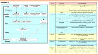
STUDY OF ENVIRONMENTAL DATA
COLLECTION AND ANALYSIS
ASSIGNMENT- 3
S.B.M.GUPTHA -21011NB003
N.SHRAVANI -21011NB007
K.RAHUL -210011NB009
TYPES OF ANALYSIS
1.TIME SERIES ANALYSIS
a) Stationary time series
b)Prediction of time series
c)Spectral analysis
d)Autoregressive moving average models
e)Prediction and modeling of ARMA processes
f) Multivariate ARMA processes
g)State-space models
2. CHAOS AND DYNAMICAL SYSTEM
a)Dynamical systems
b)Henon and logistic maps
c)Lyapunov exponents
d)Fractal dimension
e)Prediction
f) Delay embedding vectors
g)Singular spectrum analysis
h)Recurrence networks
3. APPROXIMATION
a)Trigonometric approximation
b)Multivariate approximation and dimensionality reduction
c)Polynomial approximation
d)Spline approximation and rational approximation
e)Wavelet approximation
f) Greedy algorithms
4. INTERPOLATION
a)Curve fitting
b)interpolation
c)Hermite interpolation
d)Spline interpolation
e)Trigonometric interpolation and fast Fourier transform
f) Bivariate interpolation
5. STATISTICAL METHODS
Linear regression
Multiple regression
Covariance analysis
Discriminant analysis
Cluster analysis
Principal component analysis
Canonical correlation analysis
Factor analysis
6. NUMERICAL METHODS
Numerical integration
Numerical differentiation
Iterative methods
Difference methods
Finite element methods
Wavelet methods
7. Optimization
Newton's method and steepest descent method
The variation method
The simplex method
Fermat rules
Karush-Kuhn-Tucker optimality conditions
Primal and dual pairs of linear optimization
8. Data envelopment analysis
Charnes-Cooper-Rhodes DEA models
Banker-Charnes-Cooper DEA models
One-stage and two-stage methods
Advanced DEA models
Software and case studies
9. Risk assessments
Decision rules under uncertainty
Fractile and triangular methods
The E-constraint method
The uncertainty sensitivity
index method
The partitioned multi objective risk method
Multi objective multistage impact analysis method
Multi objective risk impact analysis method
Life cycle assessments
Classic life cycle assessment
Exergetic life cycle assessment
Ecologically-based life cycle assessment
INTRODUCTION
Among major human interventions on the environment,
land use change in the form of urbanization is by far the
most important. This study is an attempt to evaluate the
impacts of land use change on a tropical environment of a
district in Kerala, India and to suggest possible
management strategies to overcome the negative
consequences.
This report was done by Aneesh, M. R., Mani and Sujith.
Study Area
Thiruvananthapuram, the capital district of the state of
Kerala, has a favourable geographical location with Arabian
Sea in the west and the Western Ghats in the east that
block the moisture laden Monsoon winds from the sea and
causes heavy rainfall. The soils of the district display
significant differences in their properties and spatial
distribution.
A CASE STUDY FROM THIRUVANANTHAPURAM DISTRICT OF KERALA, INDIA
RESULTS AND DISCUSSION
1.Driving forces (D) in the District:
The unprecedented increase in the number and density of population, increase in the proportion of economically active young
population, changes in occupational structure, decrease in man-land ratio, increase in household density, increase in industrial development
and urbanization and associated infrastructural developments were the major driving forces identified in the district.
2. Pressures (P) on the Environment:
Land use change, land conversion, deforestation, filling up of wetlands, negative aspects of industrial- urban and infrastructural
developments, and the generation of pollutants were the noticeable pressures on the environment.
3. State (s) of the environment of the District:
The present state of the district is significantly affected by rising population density, changes in occupational structure, changes in man-
land ratio and household density, industrial- urban and infrastructural developments. As a result the state of the land and water were changed
considerably. Soil degradation and water quality deterioration are
SOIL DEGRADATION INDEX
Analysis of soil degradation indices suggested that soil quality has deteriorated significantly (D.I = -923.47)
Among the different land uses, the highest degradation has happened in the case of clay mining sites, where the D.I is -403.5, followed by urban
areas (D.I= -197.31). Even the conversion from forest to forest plantation has caused considerable soil degradation.
Water Pollution Index (WPI)
Water Pollution Index (WPI) was used to assess the comprehensive status of the water quality of Karamana River. The annual average
water pollution index (WPI) of the river varied from 0.955 in forests to 4.481 in the urban environment.
Among the land uses, the water quality was highly deteriorated in the urban area, which represents impure/severely polluted water. The river
water was moderately polluted in the SMT, whereas the water quality status was much better in the forest area. On the other hand the general
WPI of the river was different from those determined in different land uses.
4.Impacts (I) on the Environment and society :
Biodiversity loss, wild life habitat loss, habitat fragmentation, human- wild life conflict, crop yield decline, increase in water borne
diseases and ill health, changes in LST and changes in micro climate are the impacts that are associated with the identified changes in the state of
the environment of the study area.
5. Response (R):
Although the government has introduced measures like family planning, control on population growth, afforestation, wetland
conservation, protection of paddy lands, urban planning, control on waste disposal in public places and water bodies, green belts development
and the control in the construction of amenities in forest areas, its implementation and execution are not so powerful and effective. These
policies and measures are still confined to papers only and its fruitful execution is still a far dream. Effective measures like strict control on
unscientific land use changes and urbanization, control on waste disposal are lacking in the district.
CONCLUSION
Land use change has resulted in severe soil degradation and water pollution in the Thiruvananthapuram district of Kerala state. Soil degradation
is most severe in the clay mining areas, followed by urban environments whereas the water pollution is extensive in the urban environment
followed by SMT.
PALLIKARANAI MARSHLAND ECOSYSTEM OF CHENNAI, INDIA
INTRODUCTION
Coastal wetlands are a critical environmental resource that
function as wild life habitat and provide various ecosystem
services. Due to rapid socio-economic development and high
population densities, wetlands are increasingly being subjected
to degradation and over-exploitation. The last 3-4 decades have
been marked by rapid deterioration of water quality, increased
pollution and consequent loss of wildlife habitat and
biodiversity.
SOURCES AND DATA
For the Pallikaranai Marshland Ecosystem in Chennai
Metropolitan Region, all the parameters used in the assessment
have been obtained from image processing of the Indian
Remote Sensing satellite digital data for the year 1997 and 2008
for all the 10 wards in the PML area.
NATURAL RESOURCES AND THEIR EXPLOITATION
The coastal and offshore environment of the
Coromandel (Chennai) coast also supports rich biodiversity
and has variety of natural ecosystems. The coastal areas of
CMR have both living and non-living marine and coastal
resources. The non-living resources include sandy beaches,
coastal dune etc., and the living resources include flora and
fauna.
There is a prominent marshland, which appears to
have formed by silting up of a former coastal lagoon
behind a spit or a barrier. The wetland is known as
Pallikaranai marshland (PML). PML. is a few meters above
the sea level and consists of black mud, in which many
water plants grow. In the 19 century, PML existed as a salt
marsh created by the backwaters of Bay of Bengal. With
the construction of Buckingham canal in 1876, the inflow
of water virtually stopped, thereafter the copious inflow of
rain water turned the swamp into a freshwater body
Hierarchical analysis of coastal ecosystems of Chennai. The marshland is an
important ecosystem of Chennai Metropolitan Region. There are no corals or sea
grasses along the coast of CMR.
PML is one of the two major ecological hotspots in the Chennai Metropolitan
Area. The wetland is a low-lying area that is flooded during the northeast
monsoon season and is located in the Kanchipuram District of Tamil Nadu
State, southwest of Chennai . It is partly saline and largely freshwater wetland
. The marshland is characterized by a variety of aquatic grass species and
waterlogged (seasonal and permanent) areas. The most recent flooding of the
marshland and the adjoining residential areas occurred in 2002.
Map showing location of the
Pallikaranai Marshland in
Chennai Metropolitan Region,
The numbers show the location
of prominent buildings and
institutes.
Google earth image of Pallikaranai Marshland. The Buckingham
Canal is also shown. The prominent plume like feature in the
marshland is the garbage dump
Photograph showing the nature of marsh vegetation (grasses) in the Pallikaranai Marshland, CMR. Note the multi-
storied buildings on the margin of the marshland.
Area under Pallikaranai Marshland in sq.km.
The morphological changes in the IML are due to
growth of residential areas.
industries.
IT corridor.
garbage dumps.
The first real effort to assess the environmental status and habitat
quality of the Pallikaranai Marshland was made in 2002, when the
Tamil Nadu Pollution Control Board (TNPCB), commissioned a
study to map the extent of the marshland (Vencatesan 2007). The
second attempt to protect the PML ecosystem was made by the
Tamil Nadu State government in April 2007 when the government
declared 317 ha of the marshland as reserve forest, and the
responsibility was handed over to the state Forest Department.
DPSIR ANALYSIS
CONCLUSION
In recent times, the public's environmental protection awareness has increased remarkably. Several non-governmental organizations
(NGOs) have taken lead in collecting valuable information about existing flora and fauna as well as in putting pressure on the concern government
departments for the conservation and protection of wetlands. Sometimes the NGOs have approached the High Court for the protection of
wetlands.
On the whole, the state of the marshland in Chennai is going from bad to worst and the negative impacts are becoming more severe.
Although human efforts to protect the coastal wetlands have been put into practice, there still seems to be a long way before the goal of
sustainability can be achieved.
STRATEGIC ASSESSMENT OF GROUNDWATER RESOURCE EXPLOITATION USING
DPSIR FRAMEWORK IN GUWAHATI CITY, INDIA
INTRODUCTION
Millions of people on the urban settlements in India rely on groundwater for fulfilling daily water needs. And while groundwater storage is vast,
its replenishment is limited, and many aquifers are exhibiting signs of inadequately controlled pumping. However, efforts to understand the
impacts of a society on the availability, equity, and sustainability of groundwater and its repercussions has received little attention till date.
The Guwahati municipality has an area of 216 km2 with the increase in urban population.The Guwahati Municipal Corporation (GMC), the Assam
Urban Water Supply and Sewerage Board (AUWSSB) and the Public Health Engineering (PHE) departments together supply drinking water to
merely 27% of the city's population, which has more than a million population, and the demand for water is constantly increasing in the city
considering its rapid population growth and urbanization. The urban households who do not have access to this network, have to depend on
their own sources as tube wells, ring wells, bore wells, etc. derived from the groundwater which goes hugely unaccounted for, and this
comprises of around 69% of the city population, with extraction estimated to be 79 million litres a day (MLD), which is beyond the safe yield
level for the city aquifers. Owing to this over-pumping of the groundwater, it is observed that the water table in many parts of the city has been
showing a declining trend, due to which the urban households are increasingly facing the challenge of water accessibility.
DPSIR FRAMEWORK
DRIVERS:
Driving forces represent major social, and economic developments in societies, and the resultant changes in the ways of peoples lives, with
enhanced production.
PRESSURES:
Change in the land cover area
Change in the land cover area is a direct form of pressure inflicted by the driving forces population explosion and urbanization.
In order to explore the changes in the land cover within the study area, a study was carried out by Borthakur and Nath( 2012) in which they took
up three time periods, i.e., 1991, 2000 and 2009, each with an interval of 9 years.
STATE:
Contamination due to solid waste disposal
This form of ‘state’ is under the influence of population explosion, urbanization and weak governance. The solid waste generation is about 350 tons
per day in the city, following which the average composition of municipal waste is mostly organic to the tune of 53.69%, approximately 24%
comprises of paper, plastic, glass and metal, and the rest 23% comprises of inert substances (Central Pollution Control Board, CPCB 2000)
IMPACT:
Vulnerability of the groundwater quality
The most severe threat for the groundwater of the area, to be faced in recent future, is its vulnerability towards pollution; shallow water table
condition combined with high transmissivity of the aquifer material is contaminating the potent environment. Of various pollution sources,
groundwater contamination through well head is also severe in the area.
RESPONSE:
Water supply projects
This form of response is aimed at the driving force, unavailability of supplied water. The Guwahati Metropolitan Development Authority (GMDA)
has tied up with the Central government, the Japan International Cooperation Agency (JICA) and the Asian Development Bank for total funding of
$452 million for taking up four water supply projects which will cover the whole city.
CONCLUSION:
Accessibility to water by urban households in Guwahati city, is greatly influenced by the socio-political factors of population growth, urbanization,
municipal services and groundwater governance as these directly or indirectly impact the groundwater resource causing depletion in its quality and
quantity. The city is practicing groundwater mining and not just drilling. So strict measures should be enforced by the govt. authorities to overcome
the issue.

ASSIGNMENT 3 final.pdf

  • 1.
    STUDY OF ENVIRONMENTALDATA COLLECTION AND ANALYSIS ASSIGNMENT- 3 S.B.M.GUPTHA -21011NB003 N.SHRAVANI -21011NB007 K.RAHUL -210011NB009
  • 2.
    TYPES OF ANALYSIS 1.TIMESERIES ANALYSIS a) Stationary time series b)Prediction of time series c)Spectral analysis d)Autoregressive moving average models e)Prediction and modeling of ARMA processes f) Multivariate ARMA processes g)State-space models
  • 3.
    2. CHAOS ANDDYNAMICAL SYSTEM a)Dynamical systems b)Henon and logistic maps c)Lyapunov exponents d)Fractal dimension e)Prediction f) Delay embedding vectors g)Singular spectrum analysis h)Recurrence networks
  • 4.
    3. APPROXIMATION a)Trigonometric approximation b)Multivariateapproximation and dimensionality reduction c)Polynomial approximation d)Spline approximation and rational approximation e)Wavelet approximation f) Greedy algorithms
  • 5.
    4. INTERPOLATION a)Curve fitting b)interpolation c)Hermiteinterpolation d)Spline interpolation e)Trigonometric interpolation and fast Fourier transform f) Bivariate interpolation
  • 6.
    5. STATISTICAL METHODS Linearregression Multiple regression Covariance analysis Discriminant analysis Cluster analysis Principal component analysis Canonical correlation analysis Factor analysis
  • 7.
    6. NUMERICAL METHODS Numericalintegration Numerical differentiation Iterative methods Difference methods Finite element methods Wavelet methods
  • 8.
    7. Optimization Newton's methodand steepest descent method The variation method The simplex method Fermat rules Karush-Kuhn-Tucker optimality conditions Primal and dual pairs of linear optimization
  • 9.
    8. Data envelopmentanalysis Charnes-Cooper-Rhodes DEA models Banker-Charnes-Cooper DEA models One-stage and two-stage methods Advanced DEA models Software and case studies
  • 10.
    9. Risk assessments Decisionrules under uncertainty Fractile and triangular methods The E-constraint method The uncertainty sensitivity index method The partitioned multi objective risk method Multi objective multistage impact analysis method Multi objective risk impact analysis method
  • 11.
    Life cycle assessments Classiclife cycle assessment Exergetic life cycle assessment Ecologically-based life cycle assessment
  • 12.
    INTRODUCTION Among major humaninterventions on the environment, land use change in the form of urbanization is by far the most important. This study is an attempt to evaluate the impacts of land use change on a tropical environment of a district in Kerala, India and to suggest possible management strategies to overcome the negative consequences. This report was done by Aneesh, M. R., Mani and Sujith. Study Area Thiruvananthapuram, the capital district of the state of Kerala, has a favourable geographical location with Arabian Sea in the west and the Western Ghats in the east that block the moisture laden Monsoon winds from the sea and causes heavy rainfall. The soils of the district display significant differences in their properties and spatial distribution. A CASE STUDY FROM THIRUVANANTHAPURAM DISTRICT OF KERALA, INDIA
  • 13.
    RESULTS AND DISCUSSION 1.Drivingforces (D) in the District: The unprecedented increase in the number and density of population, increase in the proportion of economically active young population, changes in occupational structure, decrease in man-land ratio, increase in household density, increase in industrial development and urbanization and associated infrastructural developments were the major driving forces identified in the district. 2. Pressures (P) on the Environment: Land use change, land conversion, deforestation, filling up of wetlands, negative aspects of industrial- urban and infrastructural developments, and the generation of pollutants were the noticeable pressures on the environment. 3. State (s) of the environment of the District: The present state of the district is significantly affected by rising population density, changes in occupational structure, changes in man- land ratio and household density, industrial- urban and infrastructural developments. As a result the state of the land and water were changed considerably. Soil degradation and water quality deterioration are SOIL DEGRADATION INDEX Analysis of soil degradation indices suggested that soil quality has deteriorated significantly (D.I = -923.47) Among the different land uses, the highest degradation has happened in the case of clay mining sites, where the D.I is -403.5, followed by urban areas (D.I= -197.31). Even the conversion from forest to forest plantation has caused considerable soil degradation.
  • 14.
    Water Pollution Index(WPI) Water Pollution Index (WPI) was used to assess the comprehensive status of the water quality of Karamana River. The annual average water pollution index (WPI) of the river varied from 0.955 in forests to 4.481 in the urban environment. Among the land uses, the water quality was highly deteriorated in the urban area, which represents impure/severely polluted water. The river water was moderately polluted in the SMT, whereas the water quality status was much better in the forest area. On the other hand the general WPI of the river was different from those determined in different land uses. 4.Impacts (I) on the Environment and society : Biodiversity loss, wild life habitat loss, habitat fragmentation, human- wild life conflict, crop yield decline, increase in water borne diseases and ill health, changes in LST and changes in micro climate are the impacts that are associated with the identified changes in the state of the environment of the study area. 5. Response (R): Although the government has introduced measures like family planning, control on population growth, afforestation, wetland conservation, protection of paddy lands, urban planning, control on waste disposal in public places and water bodies, green belts development and the control in the construction of amenities in forest areas, its implementation and execution are not so powerful and effective. These policies and measures are still confined to papers only and its fruitful execution is still a far dream. Effective measures like strict control on unscientific land use changes and urbanization, control on waste disposal are lacking in the district.
  • 15.
    CONCLUSION Land use changehas resulted in severe soil degradation and water pollution in the Thiruvananthapuram district of Kerala state. Soil degradation is most severe in the clay mining areas, followed by urban environments whereas the water pollution is extensive in the urban environment followed by SMT.
  • 16.
    PALLIKARANAI MARSHLAND ECOSYSTEMOF CHENNAI, INDIA INTRODUCTION Coastal wetlands are a critical environmental resource that function as wild life habitat and provide various ecosystem services. Due to rapid socio-economic development and high population densities, wetlands are increasingly being subjected to degradation and over-exploitation. The last 3-4 decades have been marked by rapid deterioration of water quality, increased pollution and consequent loss of wildlife habitat and biodiversity. SOURCES AND DATA For the Pallikaranai Marshland Ecosystem in Chennai Metropolitan Region, all the parameters used in the assessment have been obtained from image processing of the Indian Remote Sensing satellite digital data for the year 1997 and 2008 for all the 10 wards in the PML area.
  • 17.
    NATURAL RESOURCES ANDTHEIR EXPLOITATION The coastal and offshore environment of the Coromandel (Chennai) coast also supports rich biodiversity and has variety of natural ecosystems. The coastal areas of CMR have both living and non-living marine and coastal resources. The non-living resources include sandy beaches, coastal dune etc., and the living resources include flora and fauna. There is a prominent marshland, which appears to have formed by silting up of a former coastal lagoon behind a spit or a barrier. The wetland is known as Pallikaranai marshland (PML). PML. is a few meters above the sea level and consists of black mud, in which many water plants grow. In the 19 century, PML existed as a salt marsh created by the backwaters of Bay of Bengal. With the construction of Buckingham canal in 1876, the inflow of water virtually stopped, thereafter the copious inflow of rain water turned the swamp into a freshwater body Hierarchical analysis of coastal ecosystems of Chennai. The marshland is an important ecosystem of Chennai Metropolitan Region. There are no corals or sea grasses along the coast of CMR.
  • 18.
    PML is oneof the two major ecological hotspots in the Chennai Metropolitan Area. The wetland is a low-lying area that is flooded during the northeast monsoon season and is located in the Kanchipuram District of Tamil Nadu State, southwest of Chennai . It is partly saline and largely freshwater wetland . The marshland is characterized by a variety of aquatic grass species and waterlogged (seasonal and permanent) areas. The most recent flooding of the marshland and the adjoining residential areas occurred in 2002. Map showing location of the Pallikaranai Marshland in Chennai Metropolitan Region, The numbers show the location of prominent buildings and institutes. Google earth image of Pallikaranai Marshland. The Buckingham Canal is also shown. The prominent plume like feature in the marshland is the garbage dump
  • 19.
    Photograph showing thenature of marsh vegetation (grasses) in the Pallikaranai Marshland, CMR. Note the multi- storied buildings on the margin of the marshland. Area under Pallikaranai Marshland in sq.km. The morphological changes in the IML are due to growth of residential areas. industries. IT corridor. garbage dumps. The first real effort to assess the environmental status and habitat quality of the Pallikaranai Marshland was made in 2002, when the Tamil Nadu Pollution Control Board (TNPCB), commissioned a study to map the extent of the marshland (Vencatesan 2007). The second attempt to protect the PML ecosystem was made by the Tamil Nadu State government in April 2007 when the government declared 317 ha of the marshland as reserve forest, and the responsibility was handed over to the state Forest Department.
  • 20.
  • 21.
    CONCLUSION In recent times,the public's environmental protection awareness has increased remarkably. Several non-governmental organizations (NGOs) have taken lead in collecting valuable information about existing flora and fauna as well as in putting pressure on the concern government departments for the conservation and protection of wetlands. Sometimes the NGOs have approached the High Court for the protection of wetlands. On the whole, the state of the marshland in Chennai is going from bad to worst and the negative impacts are becoming more severe. Although human efforts to protect the coastal wetlands have been put into practice, there still seems to be a long way before the goal of sustainability can be achieved.
  • 22.
    STRATEGIC ASSESSMENT OFGROUNDWATER RESOURCE EXPLOITATION USING DPSIR FRAMEWORK IN GUWAHATI CITY, INDIA INTRODUCTION Millions of people on the urban settlements in India rely on groundwater for fulfilling daily water needs. And while groundwater storage is vast, its replenishment is limited, and many aquifers are exhibiting signs of inadequately controlled pumping. However, efforts to understand the impacts of a society on the availability, equity, and sustainability of groundwater and its repercussions has received little attention till date. The Guwahati municipality has an area of 216 km2 with the increase in urban population.The Guwahati Municipal Corporation (GMC), the Assam Urban Water Supply and Sewerage Board (AUWSSB) and the Public Health Engineering (PHE) departments together supply drinking water to merely 27% of the city's population, which has more than a million population, and the demand for water is constantly increasing in the city considering its rapid population growth and urbanization. The urban households who do not have access to this network, have to depend on their own sources as tube wells, ring wells, bore wells, etc. derived from the groundwater which goes hugely unaccounted for, and this comprises of around 69% of the city population, with extraction estimated to be 79 million litres a day (MLD), which is beyond the safe yield level for the city aquifers. Owing to this over-pumping of the groundwater, it is observed that the water table in many parts of the city has been showing a declining trend, due to which the urban households are increasingly facing the challenge of water accessibility. DPSIR FRAMEWORK DRIVERS: Driving forces represent major social, and economic developments in societies, and the resultant changes in the ways of peoples lives, with enhanced production. PRESSURES: Change in the land cover area Change in the land cover area is a direct form of pressure inflicted by the driving forces population explosion and urbanization.
  • 23.
    In order toexplore the changes in the land cover within the study area, a study was carried out by Borthakur and Nath( 2012) in which they took up three time periods, i.e., 1991, 2000 and 2009, each with an interval of 9 years. STATE: Contamination due to solid waste disposal This form of ‘state’ is under the influence of population explosion, urbanization and weak governance. The solid waste generation is about 350 tons per day in the city, following which the average composition of municipal waste is mostly organic to the tune of 53.69%, approximately 24% comprises of paper, plastic, glass and metal, and the rest 23% comprises of inert substances (Central Pollution Control Board, CPCB 2000) IMPACT: Vulnerability of the groundwater quality The most severe threat for the groundwater of the area, to be faced in recent future, is its vulnerability towards pollution; shallow water table condition combined with high transmissivity of the aquifer material is contaminating the potent environment. Of various pollution sources, groundwater contamination through well head is also severe in the area. RESPONSE: Water supply projects This form of response is aimed at the driving force, unavailability of supplied water. The Guwahati Metropolitan Development Authority (GMDA) has tied up with the Central government, the Japan International Cooperation Agency (JICA) and the Asian Development Bank for total funding of $452 million for taking up four water supply projects which will cover the whole city. CONCLUSION: Accessibility to water by urban households in Guwahati city, is greatly influenced by the socio-political factors of population growth, urbanization, municipal services and groundwater governance as these directly or indirectly impact the groundwater resource causing depletion in its quality and quantity. The city is practicing groundwater mining and not just drilling. So strict measures should be enforced by the govt. authorities to overcome the issue.