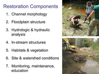
Stream Restoration
Innovations and Opportunities
Greg Jennings, PhD, PE
Professor, Biological & Agricultural Engineering
North Carolina State University
jennings@ncsu.edu
Stream: A system of
fluvial forms & habitats
•    Channel (bed & banks)
•    Floodplain
•    Water
•    Sediment
•    Plants & animals


                             Photo Credit: Eve Brantley, Auburn University
Streams are Ecosystems
•  Communities of organisms and their physical,
   chemical, and biological environments
What makes a stream healthy?
1.  Bed stability & diversity
2.  Sediment transport balance
3.  In-stream habitat & flow diversity
4.  Bank stability (native plant roots)
5.  Riparian buffer (streamside forest)
6.  Active floodplain
7.  Healthy watershed
Healthy Streams?
Stream Impairments
•  Straightening & dredging
•  Floodplain filling
•  Watershed manipulation
•  Sedimentation & stormwater
•  Pollution discharges
•  Utilities & culverts
•  Buffer removal
•  Disdain & neglect
Ecosystem Restoration
§  Activities that initiate or accelerate the
    recovery of ecosystem health, integrity, and
    sustainability (SER, 2004).
Why Restoration?
•  Water quality impairments
•  Habitat loss
•  Ecosystem degradation
•  Land loss
•  Safety concerns
•  Infrastructure damage
•  Flooding
•  Aesthetics
Standards for ecologically successful river restoration
Palmer et al., Journal of Applied Ecology, 2005, 42, 208–217

1.  design of an ecological river restoration project should be
    based on a specified guiding image of a more dynamic,
    healthy river
2.  river’s ecological condition must be measurably improved
3.  river system must be more self-sustaining and resilient to
    external perturbations so that only minimal follow-up
    maintenance is needed
4.  during the construction phase, no lasting harm should be
    inflicted on the ecosystem
5.  pre- and post-assessment must be completed and data
    made publicly available
Outcomes of Ecosystem Restoration
•  Habitats & water quality
•  Natural flow regimes
•  Recreation & aesthetics
•  Public enthusiasm
Restoration Components
 1.  Channel morphology

 2.  Floodplain structure

 3.  Hydrologic & hydraulic
     analysis

 4.  In-stream structures

 5.  Habitats & vegetation

 6.  Site & watershed conditions

 7.  Monitoring, maintenance,
     education
Stream Design Approaches
1.  Threshold Channel
2.  Alluvial Channel
  a.  Regime Equations
  b.  Analogy (Reference
      Reach)
  c.  Hydraulic Geometry
  d.  Analytical Models
3.  Combination of Methods
Threshold
Channels
Alluvial Channels
1.  Movable boundary systems
2.  Complex design approach: assess sediment continuity
    and channel performance for a range of flows
3.  Dependent variables: Width, Depth, Slope, Planform
4.  Independent variables: Sediment inflow, Water inflow,
     Bank composition
5.  Empirical & Analytical approaches should be used
    concurrently
Steady State Equilibrium
dimension, pattern and profile of the river and its
velocity have adjusted to transmit the discharge
and sediment load from its catchment under the
present climate and land use conditions without
any systematic erosion or deposition; namely
regime conditions (Hey)
Alluvial Channels – Analogy Approach
1.  Reference reach: Must have similar bed/bank materials,
    sediment inflow, slope, valley type, and hydrograph
2.  Upstream/downstream of design reach is best
3.  Nearby similar watershed acceptable
4.  Use as a starting point or check (BE CAREFUL)
Alluvial Channels – Hydraulic Geometry
Hydraulic	
  Geometry	
  Regional	
  Curves
                                         10000
                                                                                                           NC	
  Piedmont
                                                                                                           NC	
  Mtn
                                         1000                                                              MD	
  Alleghany
Bankfull	
   Discharge,	
   Q	
  (cfs)


                                                                                                           MD
                                                                                                           NY
                                          100                                                              VT
                                                                                                           OH	
  01
                                                                                                           OH	
  05
                                           10
                                                                                                           OK
                                                                                                           SW	
  OR
                                                                                                           Pacific	
  NW
                                            1
                                                                                                           AZ
                                                 0.1     1                                    10     100
                                                                                                           AZ	
  &	
  NM
                                                             Drainage	
  Area	
  (sq	
  mi)
Hydraulic	
  Geometry	
  Regional	
  Curves
                                         1000
                                                                                                          NC	
  Piedmont
                                                                                                          NC	
  Mtn
                                                                                                          MD	
  Alleghany
Cross-­‐section	
   Area	
  (sq	
  ft)


                                          100                                                             MD
                                                                                                          NY
                                                                                                          VT
                                                                                                          OH	
  01
                                          10
                                                                                                          OH	
  05
                                                                                                          OK
                                                                                                          SW	
  OR
                                                                                                          Pacific	
  NW
                                            1
                                                                                                          AZ
                                                0.1    1                                    10      100
                                                                                                          AZ	
  &	
  NM
                                                           Drainage	
  Area	
  (sq	
  mi)
Combination Approach to Natural
 Channel Design
1.  Existing Conditions – valley, watershed, constraints
2.  Design Goals
3.  Design Criteria
   a.  Regime Equations
   b.  Analogy (Reference Reach)
   c.  Hydraulic Geometry (Regional Curves)
   d.  Other Restoration Projects
4.  Analytical Models
1. Channel Morphology
  •  Dimension (baseflow, bankfull, flood flows)
  •  Pattern (meandering, straight, braided)
  •  Profile (bedform – riffle, run, pool, glide, step)


           Photo Credits: Darrell Westmoreland, North State Environmental, Inc.


2005                South Fork Mitchell River                                     2006
2011   South Fork Mitchell River
High-quality
“reference”
streams serve as
design templates
Natural Stream Channel Stability
(from Leopold)

•  River has a stable dimension, pattern and profile
•  Maintains channel features (riffles, pools, steps)
•  Does not aggrade (fills) or degrade (erodes)
Dimension
(cross-section)

•    Area
•    Width
•    Depth
•    Width/Depth Ratio
•    Entrenchment Ratio
•    Bank Height Ratio
Bankfull Stage: “incipient flooding”
  “corresponds to the discharge at which channel maintenance is the most
  effective, that is, the discharge at which moving sediment, forming or
  removing bars, forming or changing bends and meanders, and generally doing
  work results in the average morphologic characteristics” (Dunne & Leopold,
  1978)


Stream Corridor Restoration: Principles, Processes, and Practices. 1998. Federal Interagency Stream Restoration Working Group.
Terrace
Bankfull
Bankfull Width, Wbkf = 36 ft; Bankfull Area, Abkf = 112 ft2
Mean Depth, dbkf = Abkf / Wbkf = 112 / 36 = 3.1 ft
Width to Depth Ratio, W/d = Wbkf / dbkf = 36 / 3.1 = 11.5
BHR = 5.3 / 2.5 = 2.1
Entrenchment Ratio = Wfpa / Wbkf = 75/15 = 5
Meandering Stream: Alluvial Forms
Riffle     Point Bar
          (deposition)


Glide              Run
          Pool
Sinuosity = stream length / valley length
          K = 1850 / 980 = 1.9


                            Valley Length
Meander Length Ratio = meander length / width = 78/15 = 5.2
  Meander Width Ratio = belt width / width = 57/15 = 3.8
  Radius of Curvature Ratio = radius / width = 23/15 = 1.5


                                           Belt
                                           Width

Meander
Length
Profile (bedform)
Water Surface
                    Riffle Slope
                               Run Slope
                                           Glide Slope
Thalweg                                             Pool Slope


          Pool Spacing, Lp-p


 Riffle Slope Ratio, Srif / Sav
 Pool Slope Ratio, Spool / Sav
 Pool-to-Pool Spacing Ratio, Lp-p / Wbkf
2. Floodplain Structure
•  Regular (every year) flooding to relieve stress
•  Floodwater retention & riparian wetlands
•  Stormwater discharge retention & treatment
Priority 1:
       lift channel


           Incised
           Stream


 Priority 2 & 3:
lower floodplain

Stream Corridor Restoration: Principles, Processes, and Practices.
1998. Federal Interagency Stream Restoration Working Group.
Priority 1: Raise channel to existing valley
     and construct new meandering channel

                                      ER = 15; W/d = 12


Rain will come during and
immediately following construction!

2006              Town Creek Tributary             2007
Entrenchment Ratio = Wfpa / Wbkf = 150/10 = 1.6


2008          Town Creek Tributary
Priority 1: Raise channel to existing valley
    and construct new meandering channel

                               ER = 7; W/d = 14


2008               Purlear Creek                2009
Entrenchment Ratio = Wfpa / Wbkf = 100/14 = 7


2009               Purlear Creek
Priority 2: Excavate lower floodplain and
    construct new meandering channel

                                 ER = 6; W/d = 11


2008              White Slough               2010
Entrenchment Ratio = Wfpa / Wbkf = 72/12 = 6


               White Slough            2010
Priority 2: Excavate lower floodplain and
    construct new meandering channel

                               ER = 5; W/d = 11


2008          Trib to Saugatchee Creek       2008
Priority 2: Excavate lower floodplain and
     construct new meandering channel


2004           NCSU Rocky Branch              2005
2006

NCSU Rocky
  Branch

       2006
2008   NCSU Rocky Branch
Entrenchment Ratio = Wfpa / Wbkf = 48/12 = 4
Priority 3: Excavate narrow floodplain
    benches in confined systems

                            ER = 2.2; W/d = 12


2005          NCSU Rocky Branch           2006
2008   NCSU Rocky Branch
Priority 3: Excavate narrow floodplain
    benches in confined systems

                             ER = 1.6; W/d = 15


2009          Little Shades Creek         2010
Entrenchment Ratio = Wfpa / Wbkf = 60/38 = 1.6
Little Shades Creek   2010
Priority 3. Excavate floodplain benches and
    add structures to maintain straight channel

                            ER = 1.8; W/d = 14


2000          NCSU Rocky Branch             2001
NCSU
Rocky Branch

   2008
3. Hydrologic & Hydraulic Analysis
Qbkf: Bankfull discharge (cfs) appropriate for watershed size,
sediment transport & valley conditions
Vav = Qbkf / Abkf: Bankfull average velocity (ft/s) appropriate for
valley, soils, bed material
τav: Bankfull average applied shear stress (lb/ft2) & local max
stresses appropriate for sediment transport conditions & bed/
bank restistance
ωav: Bankfull average stream power (lb/ft/s) appropriate for
sediment transport conditions
Riffle substrate size distribution appropriate for hydraulic
conditions & habitats
Streambank protection to resist erosion (short-term & long-term)

Asce nc jennings

  • 1.
    Stream Restoration Innovations andOpportunities Greg Jennings, PhD, PE Professor, Biological & Agricultural Engineering North Carolina State University jennings@ncsu.edu
  • 2.
    Stream: A systemof fluvial forms & habitats •  Channel (bed & banks) •  Floodplain •  Water •  Sediment •  Plants & animals Photo Credit: Eve Brantley, Auburn University
  • 3.
    Streams are Ecosystems • Communities of organisms and their physical, chemical, and biological environments
  • 4.
    What makes astream healthy? 1.  Bed stability & diversity 2.  Sediment transport balance 3.  In-stream habitat & flow diversity 4.  Bank stability (native plant roots) 5.  Riparian buffer (streamside forest) 6.  Active floodplain 7.  Healthy watershed
  • 5.
  • 6.
    Stream Impairments •  Straightening& dredging •  Floodplain filling •  Watershed manipulation •  Sedimentation & stormwater •  Pollution discharges •  Utilities & culverts •  Buffer removal •  Disdain & neglect
  • 7.
    Ecosystem Restoration §  Activitiesthat initiate or accelerate the recovery of ecosystem health, integrity, and sustainability (SER, 2004).
  • 8.
    Why Restoration? •  Waterquality impairments •  Habitat loss •  Ecosystem degradation •  Land loss •  Safety concerns •  Infrastructure damage •  Flooding •  Aesthetics
  • 9.
    Standards for ecologicallysuccessful river restoration Palmer et al., Journal of Applied Ecology, 2005, 42, 208–217 1.  design of an ecological river restoration project should be based on a specified guiding image of a more dynamic, healthy river 2.  river’s ecological condition must be measurably improved 3.  river system must be more self-sustaining and resilient to external perturbations so that only minimal follow-up maintenance is needed 4.  during the construction phase, no lasting harm should be inflicted on the ecosystem 5.  pre- and post-assessment must be completed and data made publicly available
  • 10.
    Outcomes of EcosystemRestoration •  Habitats & water quality •  Natural flow regimes •  Recreation & aesthetics •  Public enthusiasm
  • 11.
    Restoration Components 1. Channel morphology 2.  Floodplain structure 3.  Hydrologic & hydraulic analysis 4.  In-stream structures 5.  Habitats & vegetation 6.  Site & watershed conditions 7.  Monitoring, maintenance, education
  • 12.
    Stream Design Approaches 1. Threshold Channel 2.  Alluvial Channel a.  Regime Equations b.  Analogy (Reference Reach) c.  Hydraulic Geometry d.  Analytical Models 3.  Combination of Methods
  • 13.
  • 14.
    Alluvial Channels 1.  Movableboundary systems 2.  Complex design approach: assess sediment continuity and channel performance for a range of flows 3.  Dependent variables: Width, Depth, Slope, Planform 4.  Independent variables: Sediment inflow, Water inflow, Bank composition 5.  Empirical & Analytical approaches should be used concurrently
  • 15.
    Steady State Equilibrium dimension,pattern and profile of the river and its velocity have adjusted to transmit the discharge and sediment load from its catchment under the present climate and land use conditions without any systematic erosion or deposition; namely regime conditions (Hey)
  • 16.
    Alluvial Channels –Analogy Approach 1.  Reference reach: Must have similar bed/bank materials, sediment inflow, slope, valley type, and hydrograph 2.  Upstream/downstream of design reach is best 3.  Nearby similar watershed acceptable 4.  Use as a starting point or check (BE CAREFUL)
  • 17.
    Alluvial Channels –Hydraulic Geometry
  • 18.
    Hydraulic  Geometry  Regional  Curves 10000 NC  Piedmont NC  Mtn 1000 MD  Alleghany Bankfull   Discharge,   Q  (cfs) MD NY 100 VT OH  01 OH  05 10 OK SW  OR Pacific  NW 1 AZ 0.1 1 10 100 AZ  &  NM Drainage  Area  (sq  mi)
  • 19.
    Hydraulic  Geometry  Regional  Curves 1000 NC  Piedmont NC  Mtn MD  Alleghany Cross-­‐section   Area  (sq  ft) 100 MD NY VT OH  01 10 OH  05 OK SW  OR Pacific  NW 1 AZ 0.1 1 10 100 AZ  &  NM Drainage  Area  (sq  mi)
  • 20.
    Combination Approach toNatural Channel Design 1.  Existing Conditions – valley, watershed, constraints 2.  Design Goals 3.  Design Criteria a.  Regime Equations b.  Analogy (Reference Reach) c.  Hydraulic Geometry (Regional Curves) d.  Other Restoration Projects 4.  Analytical Models
  • 21.
    1. Channel Morphology •  Dimension (baseflow, bankfull, flood flows) •  Pattern (meandering, straight, braided) •  Profile (bedform – riffle, run, pool, glide, step) Photo Credits: Darrell Westmoreland, North State Environmental, Inc. 2005 South Fork Mitchell River 2006
  • 22.
    2011 South Fork Mitchell River
  • 23.
    2011 South Fork Mitchell River
  • 24.
  • 25.
    Natural Stream ChannelStability (from Leopold) •  River has a stable dimension, pattern and profile •  Maintains channel features (riffles, pools, steps) •  Does not aggrade (fills) or degrade (erodes)
  • 26.
    Dimension (cross-section) •  Area •  Width •  Depth •  Width/Depth Ratio •  Entrenchment Ratio •  Bank Height Ratio
  • 27.
    Bankfull Stage: “incipientflooding” “corresponds to the discharge at which channel maintenance is the most effective, that is, the discharge at which moving sediment, forming or removing bars, forming or changing bends and meanders, and generally doing work results in the average morphologic characteristics” (Dunne & Leopold, 1978) Stream Corridor Restoration: Principles, Processes, and Practices. 1998. Federal Interagency Stream Restoration Working Group.
  • 28.
  • 29.
    Bankfull Width, Wbkf= 36 ft; Bankfull Area, Abkf = 112 ft2 Mean Depth, dbkf = Abkf / Wbkf = 112 / 36 = 3.1 ft Width to Depth Ratio, W/d = Wbkf / dbkf = 36 / 3.1 = 11.5
  • 30.
    BHR = 5.3/ 2.5 = 2.1
  • 31.
    Entrenchment Ratio =Wfpa / Wbkf = 75/15 = 5
  • 32.
    Meandering Stream: AlluvialForms Riffle Point Bar (deposition) Glide Run Pool
  • 33.
    Sinuosity = streamlength / valley length K = 1850 / 980 = 1.9 Valley Length
  • 34.
    Meander Length Ratio= meander length / width = 78/15 = 5.2 Meander Width Ratio = belt width / width = 57/15 = 3.8 Radius of Curvature Ratio = radius / width = 23/15 = 1.5 Belt Width Meander Length
  • 35.
    Profile (bedform) Water Surface Riffle Slope Run Slope Glide Slope Thalweg Pool Slope Pool Spacing, Lp-p Riffle Slope Ratio, Srif / Sav Pool Slope Ratio, Spool / Sav Pool-to-Pool Spacing Ratio, Lp-p / Wbkf
  • 36.
    2. Floodplain Structure • Regular (every year) flooding to relieve stress •  Floodwater retention & riparian wetlands •  Stormwater discharge retention & treatment
  • 37.
    Priority 1: lift channel Incised Stream Priority 2 & 3: lower floodplain Stream Corridor Restoration: Principles, Processes, and Practices. 1998. Federal Interagency Stream Restoration Working Group.
  • 38.
    Priority 1: Raisechannel to existing valley and construct new meandering channel ER = 15; W/d = 12 Rain will come during and immediately following construction! 2006 Town Creek Tributary 2007
  • 39.
    Entrenchment Ratio =Wfpa / Wbkf = 150/10 = 1.6 2008 Town Creek Tributary
  • 40.
    Priority 1: Raisechannel to existing valley and construct new meandering channel ER = 7; W/d = 14 2008 Purlear Creek 2009
  • 41.
    Entrenchment Ratio =Wfpa / Wbkf = 100/14 = 7 2009 Purlear Creek
  • 42.
    Priority 2: Excavatelower floodplain and construct new meandering channel ER = 6; W/d = 11 2008 White Slough 2010
  • 43.
    Entrenchment Ratio =Wfpa / Wbkf = 72/12 = 6 White Slough 2010
  • 44.
    Priority 2: Excavatelower floodplain and construct new meandering channel ER = 5; W/d = 11 2008 Trib to Saugatchee Creek 2008
  • 45.
    Priority 2: Excavatelower floodplain and construct new meandering channel 2004 NCSU Rocky Branch 2005
  • 46.
    2006 NCSU Rocky Branch 2006
  • 47.
    2008 NCSU Rocky Branch
  • 49.
    Entrenchment Ratio =Wfpa / Wbkf = 48/12 = 4
  • 50.
    Priority 3: Excavatenarrow floodplain benches in confined systems ER = 2.2; W/d = 12 2005 NCSU Rocky Branch 2006
  • 51.
    2008 NCSU Rocky Branch
  • 52.
    Priority 3: Excavatenarrow floodplain benches in confined systems ER = 1.6; W/d = 15 2009 Little Shades Creek 2010
  • 53.
    Entrenchment Ratio =Wfpa / Wbkf = 60/38 = 1.6
  • 54.
  • 55.
    Priority 3. Excavatefloodplain benches and add structures to maintain straight channel ER = 1.8; W/d = 14 2000 NCSU Rocky Branch 2001
  • 56.
  • 57.
    3. Hydrologic &Hydraulic Analysis Qbkf: Bankfull discharge (cfs) appropriate for watershed size, sediment transport & valley conditions Vav = Qbkf / Abkf: Bankfull average velocity (ft/s) appropriate for valley, soils, bed material τav: Bankfull average applied shear stress (lb/ft2) & local max stresses appropriate for sediment transport conditions & bed/ bank restistance ωav: Bankfull average stream power (lb/ft/s) appropriate for sediment transport conditions Riffle substrate size distribution appropriate for hydraulic conditions & habitats Streambank protection to resist erosion (short-term & long-term)