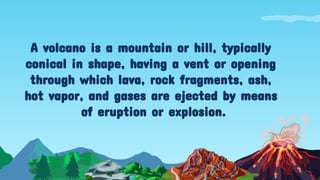
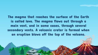
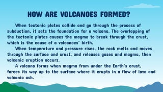
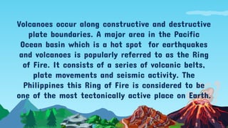
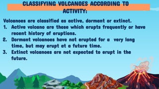
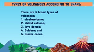
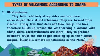
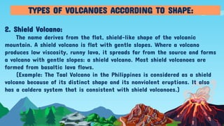
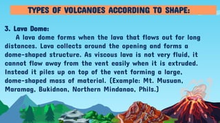
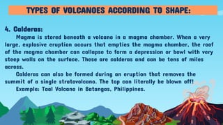
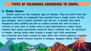
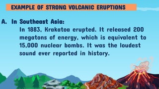
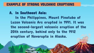
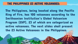
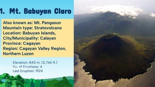
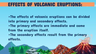
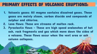
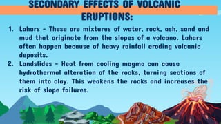
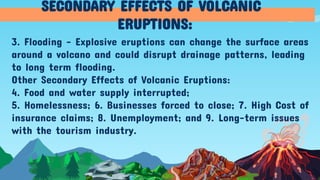
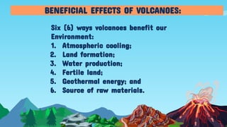
Volcanoes in the
Philippines
Presented by: ADELINE P. DELA CRUZ
For the course Elements in Geography
A volcano is a mountain or hill, typically
conical in shape, having a vent or opening
through which lava, rock fragments, ash,
hot vapor, and gases are ejected by means
of eruption or explosion.
The magma that reaches the surface of the Earth
is called lava. The magma flows out through a
main vent, and in some cases, through several
secondary vents. A volcanic crater is formed when
an eruption blows off the top of the volcano.
HOW ARE VOLCANOES FORMED?
When tectonic plates collide and go through the process of
subduction, it sets the foundation for a volcano. The overlapping of
the tectonic plates causes the magma to break through the crust,
which is the cause of a volcanoes’ birth.
When temperature and pressure rises, the rock melts and moves
through the surface and crust, and releases gases and magma, then
volcanic eruption occurs.
A volcano forms when magma from under the Earth’s crust,
forces its way up to the surface where it erupts in a flow of lava and
volcanic ash.
Volcanoes occur along constructive and destructive
plate boundaries. A major area in the Pacific
Ocean basin which is a hot spot for earthquakes
and volcanoes is popularly referred to as the Ring
of Fire. It consists of a series of volcanic belts,
plate movements and seismic activity. The
Philippines this Ring of Fire is considered to be
one of the most tectonically active place on Earth.
Volcanoes are classified as active, dormant or extinct.
1. Active volcano are those which erupts frequently or have
recent history of eruptions.
2. Dormant volcanoes have not erupted for a very long
time, but may erupt at a future time.
3. Extinct volcanoes are not expected to erupt in the
future.
CLASSIFYING VOLCANOES ACCORDING TO
ACTIVITY:
There are 5 broad types of
volcanoes:
1. stratovolcano;
2. shield volcano;
3. lava domes;
4. Caldera; and
5. cinder cones.
TYPES OF VOLCANOES ACCORDING TO SHAPE:
1. Stratovolcano:
They have relatively steep sides and are more
cone-shaped than shield volcanoes. They are formed from
viscous, sticky lava that does not flow easily. The lava
therefore builds up around the vent forming a volcano with
steep sides. Stratovolcanoes are more likely to produce
explosive eruptions due to gas building up in the viscous
magma. (Example: almost all volcanoes in the Phils.)
TYPES OF VOLCANOES ACCORDING TO SHAPE:
2. Shield Volcano:
The name derives from the flat, shield-like shape of the volcanic
mountain. A shield volcano is flat with gentle slopes. Where a volcano
produces low viscosity, runny lava, it spreads far from the source and forms
a volcano with gentle slopes: a shield volcano. Most shield volcanoes are
formed from basaltic lava flows.
(Example: The Taal Volcano in the Philippines is considered as a shield
volcano because of its distinct shape and its nonviolent eruptions. It also
has a caldera system that is consistent with shield volcanoes.)
TYPES OF VOLCANOES ACCORDING TO SHAPE:
3. Lava Dome:
A lava dome forms when the lava that flows out for long
distances. Lava collects around the opening and forms a
dome-shaped structure. As viscous lava is not very fluid, it
cannot flow away from the vent easily when it is extruded.
Instead it piles up on top of the vent forming a large,
dome-shaped mass of material. (Example: Mt. Musuan,
Maramag, Bukidnon, Northern Mindanao, Phils.)
TYPES OF VOLCANOES ACCORDING TO SHAPE:
4. Calderas:
Magma is stored beneath a volcano in a magma chamber. When a very
large, explosive eruption occurs that empties the magma chamber, the roof
of the magma chamber can collapse to form a depression or bowl with very
steep walls on the surface. These are calderas and can be tens of miles
across.
Calderas can also be formed during an eruption that removes the
summit of a single stratovolcano. The top can literally be blown off!
Example: Taal Volcano in Batangas, Philippines.
TYPES OF VOLCANOES ACCORDING TO SHAPE:
5. Cinder Cones:
Cinder cones are the simplest type of volcano. They are built from the
particles and blobs of congealed lava ejected from a single event. As the
gas-charged lava is blown violently into the air, it breaks into small
fragments that solidify and fall as cinders around the vent to form a
circular or oval cone. A cinder cone is best described as a short steep
volcano that ejects pyroclastic material from a central vent. Its structure
is simple, having steep sides around a single vent with occasional
low-viscosity lava flows around its base after the initial explosive eruption.
Example: Smith Volcano located in Calayan, Cagayan Valley, Phils.
TYPES OF VOLCANOES ACCORDING TO SHAPE:
A. In Southeast Asia:
In 1883, Krakatoa erupted. It released 200
megatons of energy, which is equivalent to
15,000 nuclear bombs. It was the loudest
sound ever reported in history.
EXAMPLE OF STRONG VOLCANIC ERUPTIONS
A. In Southeast Asia:
In the Philippines, Mount Pinatubo of
Luzon Volcanic Arc erupted in 1991. It was
the second-largest volcanic eruption of the
20th century, behind only to the 1912
eruption of Novarupta in Alaska.
EXAMPLE OF STRONG VOLCANIC ERUPTIONS
The Philippines, being located along the Pacific
Ring of Fire, has 100 volcanoes according to the
Smithsonian Institution’s Global Volcanism
Program (GVP), 23 of which are categorized as
active volcanoes. The next slides shall present
the 23 Active Volcanoes in the Philippines.
THE PHILIPPINES 23 ACTIVE VOLCANOES:
23 ACTIVE
VOLCANOES
IN THE PHILIPPINES
*Arranged in alphabetical order
Elevation: 843 m. (2,766 ft.)
No. of Eruptions: 4
Last Eruption: 1924
Also known as: Mt. Pangasun
Mountain type: Stratovolcano
Location: Babuyan Islands,
City/Municipality: Calayan
Province: Cagayan
Region: Cagayan Valley Region,
Northern Luzon
1. Mt. Babuyan Claro
Elevation: 2,170 m. (7,120 ft.)
No. of Eruptions: 3
Last Eruption: 1909
Also spelled as: Banahao, Banajao
Considered as holy mountain, is popular
among pilgrims and mountain climbers.
Mountain type: Stratovolcano complex
Municipalities: Lucban, Majayjay,
Nagcarlan, Rizal, San Pablo, Sariaya, and
Tayabas.
Province: Laguna and Quezon
Region: CALABARZON
2. Mt. Banahaw
Elevation: 1,340 m. (4,400 ft.)
No. of Eruptions: 1
Last Eruption: Sept. 26, 1939
Mountain Type:
Stratovolcano Complex
Location: Biliran Island,
Biliran Province, Leyte
Eastern Visayas Region
Note: This volcano caused
the formation of Biliran
Island.
3. Mt. Biliran
Elevation: 620 m. (2,034 ft.)
No. of Eruptions: 2
Last Eruption: Jan. 4, 1641
Location: Jolo Island
Province: Sulu
Region: BARMM
Note: A tsunami occurred
in 1897, probably caused a
local submarine eruption
by this volcano.
4. Mt.Bud Dajo
Elevation: 1,565 m. (5,135 ft.)
No. of Eruptions: 17
Last Eruption: June 12, 2022
Mt. Type: Stratovolcano
Municipality: Bulusan,
Barcelona, Casiguran, Gubat,
Irosin, Juban
Province: Sorsogon
Region: Bicol
5. Mt. Bulusan
Elevation: 945 m. (3,100 ft.)
No. of Eruptions: 1820 +-30
Mt. Type: Stratovolcano
Location: Southern Leyte
Region: Region VIII
*Cabalian Lake (Lake Danao) is a
500m wide crater lake that
occupies the summit crater of the
volcano.
**Mainit Hot Spring in the
municipality of Anahawan, So.
Leyte has a temperature of 63.4 to
63.9 degrees Centigrade.
6. Mt. Cabalian
Elevation: 1,133 m. (3,717 ft.)
No. of Eruptions: 2
Last Eruption: October 1907
Mt. type: Stratovolcano
Municipality: Gonzaga
Province: Cagayan
Region: Cagayan Valley,
Northern Luzon
Parent Range: Sierra Madre
7. Mt. Cagua
Elevation: 712 m. (2,336 ft.)
No. of Eruptions: 1
Last Eruption: 1857
Also known as: Camiguin Norte to
distinguish it from Camiguin Sur
which is in Mindanao.
Mt. type: Stratovolcano
Location: Camiguin Island,
Calayan, Cagayan
8. Camiguin
Babuyanes
Elevation: 228 m. (748 ft.)
Last Eruption: Jan. 6-9, 1978
No. of Eruptions: 8
1) 1773
2) 1856
3) 1857
4) 1900
5) 1952
6) 1953
7) 1969
8) 1978
Mt. type: Volcanic Islands
Province: Cagayan
Region: Cagayan Valley
9. Mt. Didicas
Elevation: 1,332 m. (4,370 ft.)
No. of Eruptions: 5
Last Eruption: Sept. 1948 to
July 1953
Mt. Type: Stratovolcano
Province: Camiguin
Region: Northern Mindanao
It has 6 hot springs: Ardent
Spring, Tangob, Bugong,
Tagdo, Naasag, and Kiyab.
It has 3 craters: Kanangkaan
crater, Itum Crater, Ilihan
Crater.
10.Mt. Hibok-hibok
Elevation: 1,009 m. (3,310 ft.)
No. of Eruptions: 1
Last Eruption: 1454
Mt. Type: Stratovolcano
Province: Batanes
Region: Cagayan Valley
It is a sacred mountain of the
Ivatan people.
Mythology: 2 contrasting
tales…
11. Mt. Iraya
Elevation: 1,196 m. (3,924 ft.)
No. of Eruptions: 2
Last Eruption: Jan. 4, 1642
Also known as Mt. Asog
Mt. Type: Stratovolcano
City/Municipality: Buhi, Iriga
Province: Camarines Sur
Region: Bicol
12. Mt. Iriga
Elevation: 2,465 m. (8,087 ft.)
No. of Eruptions: 26
Last Eruption: June 3, 2024
Mt. Type: Stratovolcano
City/Municipality: Canlaon, La
Carlota, La Castellana, Murcia,
San Carlos
Provinces: Negros Oriental,
Negros Occidental
Region: Negros Island Region
Etymology: “Kanlaon” means
“place of Laon,” a precolonial
goddess of creation, agriculture
and justice. “Laon” also ancient.
13. Mt.Kanlaon
Elevation: 1,190 m. (3,900 ft.)
No. of Eruptions: 0
Last Eruption: 120 A.D.
Mt. Type: Stratovolcano
City/municipality: Mabini,
Marco
Province: Davao de Oro
Region: Davao, Mindanao
14. Leonard
Kniaseff
Elevation: 1,940 m. (6,360 ft.)
No. of Eruptions: 10
Last Eruption: March 1882
Mt. Type: Stratovolcano
Locally, it is called Palaw a
Magatoring.
City/municipality: Butig
Province: Lanao del Sur
Region: BARMM
15.Mt.Makaturing
Elevation: 2,286 m. (7,500 ft.)
No. of Eruptions: 1
Last Eruption: March 7, 1911
Mt. Type: Stratovolcano
City/Municipality: Tupi
Province: South Cotabato
Region: Soccsksargen
16.Mt. Matutum
Elevation: 2,463 m. (8,081 ft.)
No. of Eruptions: 49
Last Eruption: Sept. 2024
Also Mayon Volcano, famous for
its perfect cone shape, it is the
most active volcano in the Phils.
It is the main landmark of Albay
and the whole Bicol Region.
Mt. type: Stratovolcano
Cities/Municipalities: Camalig,
Daraga, Guinobatan, Legazpi,
Ligao, Malilipot, Santo Domingo,
Tabaco.
Province: Albay
Region: Bicol
17. Mt. Mayon
Elevation: 646 m. (2,119 ft.)
No. of Eruptions: 2
Last Eruption: 1887
Also known as Musuan
Peak, or Mt. Calayan
Mt. Type: Lava Dome
City/Municipality: Maramag
Province: Bukidnon
Region: Northern Mindanao
18. Mt. Musuan
Elevation: 1,824 m. (5,984 ft.)
No. of Eruptions: 1
Last Eruption: Jan. 4, 1640
Mt. Type: Stratovolcano
Municipality: T’boli
Province: South Cotabato
Region: Soccsksargen
*Now Mt. Melibengoy
19.Parker Volcano
Elevation: 1,486 m. ( 4,875 ft.)
No. of Eruptions: 3
Last Eruption: Nov. 30, 2021
Mt. Type: Stratovolcano
Provinces: Pampanga,
Tarlac, Zambales
Region: Central Luzon
Parent Range: Zambales
Mountain Range
*Known for its VEI-6
eruption on June 6, 1991.
20. Mt. Pinatubo
Elevation: 2,815 m. (9,236 ft.)
No. of Eruptions: 8
Last Eruption: July 1916
Mt. Type: Stratovolcano
Province: Lanao del Sur
Regions: BARRM, Soccsksargen,
Lanao del Sur
Parent Range: Piapayungan Range
Also known as: Mt. Piapayungan
21. Mt. Ragang
Elevation: 688 m. (2,257 ft.)
No. of Eruptions: 5
Last Eruption: 1924
Mt. Type: Cinder Cone
A.k.a. Mt. Babuyan
Municipality: Calayan
Province: Cagayan
Region: Cagayan Valley
22. Smith Volcano
Elevation: 311 m. (1,020 ft.)
No. of Eruptions: 33
Last Eruption: June 6, 2024
Mt. Type: Caldera
Location: Talisay and San
Nicolas, Batangas
Etymology: “Taal” is a
Tagalog word in the
Batangueno dialect which
means true, genuine, and
pure.
23. Taal Volcano
•The effects of volcanic eruptions can be divided
into primary and secondary effects.
•The primary effects are immediate and come
from the eruption itself.
•The secondary effects result from the primary
effects.
EFFECTS OF VOLCANIC ERUPTIONS:
1. Volcanic gases: All magma contains dissolved gases. These
gases are mainly steam, carbon dioxide and compounds of
sulphur and chlorine.
2. Lava flows: These are streams of molten rock.
3. Pyroclastic flows - These are high speed avalanches of hot
ash, rock fragments and gas which move down the sides of
a volcano. These flows occur when the vent area or ash
column collapses.
PRIMARY EFFECTS OF VOLCANIC ERUPTIONS:
1. Lahars - These are mixtures of water, rock, ash, sand and
mud that originate from the slopes of a volcano. Lahars
often happen because of heavy rainfall eroding volcanic
deposits.
2. Landslides - Heat from cooling magma can cause
hydrothermal alteration of the rocks, turning sections of
them into clay. This weakens the rocks and increases the
risk of slope failures.
SECONDARY EFFECTS OF VOLCANIC
ERUPTIONS:
3. Flooding - Explosive eruptions can change the surface areas
around a volcano and could disrupt drainage patterns, leading
to long term flooding.
Other Secondary Effects of Volcanic Eruptions:
4. Food and water supply interrupted;
5. Homelessness; 6. Businesses forced to close; 7. High Cost of
insurance claims; 8. Unemployment; and 9. Long-term issues
with the tourism industry.
SECONDARY EFFECTS OF VOLCANIC
ERUPTIONS:
Six (6) ways volcanoes benefit our
Environment:
1. Atmospheric cooling;
2. Land formation;
3. Water production;
4. Fertile land;
5. Geothermal energy; and
6. Source of raw materials.
BENEFICIAL EFFECTS OF VOLCANOES:
Volcanic Eruption can cause heavy damage to human life
and property.
Although volcanic eruptions are threats to human life, but
they have beneficial effects to the area.
The land areas where the eruption occurred would be
enriched with minerals and making the land fertile.
They have helped create the beautiful Philippine Islands
and have boosted tourism activities in these areas.
CONCLUSION:
Famous Quotes on Volcanoes:
“The origin of volcanic energy is one of the blankest mysteries
of science, and it strange indeed, that a class of phenomena so
long familiar to the human race and so zealously studied through
all the ages should be so utterly without explanation.”
By Clarence Edward Dutton (1841-1912), American geologist who was the first head
of the USGS division of volcanic geology (1887). He coined the term “isostacy” for
his explanation that continents rise higher on the Earth’s surface by virtue of their
less dense crustal rock.
https://todayinsci.com/D/Dutton_Clarence/DuttonClarence-Quotations.htm
CREDITS: This presentation template was created by Slidesgo, and
includes icons by Flaticon, and infographics & images by Freepik
THANK
YOU!

ACTIVE VOLCANOES IN THE PHILIPPINES .pdf

  • 1.
    Volcanoes in the Philippines Presentedby: ADELINE P. DELA CRUZ For the course Elements in Geography
  • 2.
    A volcano isa mountain or hill, typically conical in shape, having a vent or opening through which lava, rock fragments, ash, hot vapor, and gases are ejected by means of eruption or explosion.
  • 3.
    The magma thatreaches the surface of the Earth is called lava. The magma flows out through a main vent, and in some cases, through several secondary vents. A volcanic crater is formed when an eruption blows off the top of the volcano.
  • 4.
    HOW ARE VOLCANOESFORMED? When tectonic plates collide and go through the process of subduction, it sets the foundation for a volcano. The overlapping of the tectonic plates causes the magma to break through the crust, which is the cause of a volcanoes’ birth. When temperature and pressure rises, the rock melts and moves through the surface and crust, and releases gases and magma, then volcanic eruption occurs. A volcano forms when magma from under the Earth’s crust, forces its way up to the surface where it erupts in a flow of lava and volcanic ash.
  • 5.
    Volcanoes occur alongconstructive and destructive plate boundaries. A major area in the Pacific Ocean basin which is a hot spot for earthquakes and volcanoes is popularly referred to as the Ring of Fire. It consists of a series of volcanic belts, plate movements and seismic activity. The Philippines this Ring of Fire is considered to be one of the most tectonically active place on Earth.
  • 6.
    Volcanoes are classifiedas active, dormant or extinct. 1. Active volcano are those which erupts frequently or have recent history of eruptions. 2. Dormant volcanoes have not erupted for a very long time, but may erupt at a future time. 3. Extinct volcanoes are not expected to erupt in the future. CLASSIFYING VOLCANOES ACCORDING TO ACTIVITY:
  • 7.
    There are 5broad types of volcanoes: 1. stratovolcano; 2. shield volcano; 3. lava domes; 4. Caldera; and 5. cinder cones. TYPES OF VOLCANOES ACCORDING TO SHAPE:
  • 8.
    1. Stratovolcano: They haverelatively steep sides and are more cone-shaped than shield volcanoes. They are formed from viscous, sticky lava that does not flow easily. The lava therefore builds up around the vent forming a volcano with steep sides. Stratovolcanoes are more likely to produce explosive eruptions due to gas building up in the viscous magma. (Example: almost all volcanoes in the Phils.) TYPES OF VOLCANOES ACCORDING TO SHAPE:
  • 9.
    2. Shield Volcano: Thename derives from the flat, shield-like shape of the volcanic mountain. A shield volcano is flat with gentle slopes. Where a volcano produces low viscosity, runny lava, it spreads far from the source and forms a volcano with gentle slopes: a shield volcano. Most shield volcanoes are formed from basaltic lava flows. (Example: The Taal Volcano in the Philippines is considered as a shield volcano because of its distinct shape and its nonviolent eruptions. It also has a caldera system that is consistent with shield volcanoes.) TYPES OF VOLCANOES ACCORDING TO SHAPE:
  • 10.
    3. Lava Dome: Alava dome forms when the lava that flows out for long distances. Lava collects around the opening and forms a dome-shaped structure. As viscous lava is not very fluid, it cannot flow away from the vent easily when it is extruded. Instead it piles up on top of the vent forming a large, dome-shaped mass of material. (Example: Mt. Musuan, Maramag, Bukidnon, Northern Mindanao, Phils.) TYPES OF VOLCANOES ACCORDING TO SHAPE:
  • 11.
    4. Calderas: Magma isstored beneath a volcano in a magma chamber. When a very large, explosive eruption occurs that empties the magma chamber, the roof of the magma chamber can collapse to form a depression or bowl with very steep walls on the surface. These are calderas and can be tens of miles across. Calderas can also be formed during an eruption that removes the summit of a single stratovolcano. The top can literally be blown off! Example: Taal Volcano in Batangas, Philippines. TYPES OF VOLCANOES ACCORDING TO SHAPE:
  • 12.
    5. Cinder Cones: Cindercones are the simplest type of volcano. They are built from the particles and blobs of congealed lava ejected from a single event. As the gas-charged lava is blown violently into the air, it breaks into small fragments that solidify and fall as cinders around the vent to form a circular or oval cone. A cinder cone is best described as a short steep volcano that ejects pyroclastic material from a central vent. Its structure is simple, having steep sides around a single vent with occasional low-viscosity lava flows around its base after the initial explosive eruption. Example: Smith Volcano located in Calayan, Cagayan Valley, Phils. TYPES OF VOLCANOES ACCORDING TO SHAPE:
  • 13.
    A. In SoutheastAsia: In 1883, Krakatoa erupted. It released 200 megatons of energy, which is equivalent to 15,000 nuclear bombs. It was the loudest sound ever reported in history. EXAMPLE OF STRONG VOLCANIC ERUPTIONS
  • 14.
    A. In SoutheastAsia: In the Philippines, Mount Pinatubo of Luzon Volcanic Arc erupted in 1991. It was the second-largest volcanic eruption of the 20th century, behind only to the 1912 eruption of Novarupta in Alaska. EXAMPLE OF STRONG VOLCANIC ERUPTIONS
  • 15.
    The Philippines, beinglocated along the Pacific Ring of Fire, has 100 volcanoes according to the Smithsonian Institution’s Global Volcanism Program (GVP), 23 of which are categorized as active volcanoes. The next slides shall present the 23 Active Volcanoes in the Philippines. THE PHILIPPINES 23 ACTIVE VOLCANOES:
  • 16.
    23 ACTIVE VOLCANOES IN THEPHILIPPINES *Arranged in alphabetical order
  • 17.
    Elevation: 843 m.(2,766 ft.) No. of Eruptions: 4 Last Eruption: 1924 Also known as: Mt. Pangasun Mountain type: Stratovolcano Location: Babuyan Islands, City/Municipality: Calayan Province: Cagayan Region: Cagayan Valley Region, Northern Luzon 1. Mt. Babuyan Claro
  • 18.
    Elevation: 2,170 m.(7,120 ft.) No. of Eruptions: 3 Last Eruption: 1909 Also spelled as: Banahao, Banajao Considered as holy mountain, is popular among pilgrims and mountain climbers. Mountain type: Stratovolcano complex Municipalities: Lucban, Majayjay, Nagcarlan, Rizal, San Pablo, Sariaya, and Tayabas. Province: Laguna and Quezon Region: CALABARZON 2. Mt. Banahaw
  • 19.
    Elevation: 1,340 m.(4,400 ft.) No. of Eruptions: 1 Last Eruption: Sept. 26, 1939 Mountain Type: Stratovolcano Complex Location: Biliran Island, Biliran Province, Leyte Eastern Visayas Region Note: This volcano caused the formation of Biliran Island. 3. Mt. Biliran
  • 20.
    Elevation: 620 m.(2,034 ft.) No. of Eruptions: 2 Last Eruption: Jan. 4, 1641 Location: Jolo Island Province: Sulu Region: BARMM Note: A tsunami occurred in 1897, probably caused a local submarine eruption by this volcano. 4. Mt.Bud Dajo
  • 21.
    Elevation: 1,565 m.(5,135 ft.) No. of Eruptions: 17 Last Eruption: June 12, 2022 Mt. Type: Stratovolcano Municipality: Bulusan, Barcelona, Casiguran, Gubat, Irosin, Juban Province: Sorsogon Region: Bicol 5. Mt. Bulusan
  • 22.
    Elevation: 945 m.(3,100 ft.) No. of Eruptions: 1820 +-30 Mt. Type: Stratovolcano Location: Southern Leyte Region: Region VIII *Cabalian Lake (Lake Danao) is a 500m wide crater lake that occupies the summit crater of the volcano. **Mainit Hot Spring in the municipality of Anahawan, So. Leyte has a temperature of 63.4 to 63.9 degrees Centigrade. 6. Mt. Cabalian
  • 23.
    Elevation: 1,133 m.(3,717 ft.) No. of Eruptions: 2 Last Eruption: October 1907 Mt. type: Stratovolcano Municipality: Gonzaga Province: Cagayan Region: Cagayan Valley, Northern Luzon Parent Range: Sierra Madre 7. Mt. Cagua
  • 24.
    Elevation: 712 m.(2,336 ft.) No. of Eruptions: 1 Last Eruption: 1857 Also known as: Camiguin Norte to distinguish it from Camiguin Sur which is in Mindanao. Mt. type: Stratovolcano Location: Camiguin Island, Calayan, Cagayan 8. Camiguin Babuyanes
  • 25.
    Elevation: 228 m.(748 ft.) Last Eruption: Jan. 6-9, 1978 No. of Eruptions: 8 1) 1773 2) 1856 3) 1857 4) 1900 5) 1952 6) 1953 7) 1969 8) 1978 Mt. type: Volcanic Islands Province: Cagayan Region: Cagayan Valley 9. Mt. Didicas
  • 26.
    Elevation: 1,332 m.(4,370 ft.) No. of Eruptions: 5 Last Eruption: Sept. 1948 to July 1953 Mt. Type: Stratovolcano Province: Camiguin Region: Northern Mindanao It has 6 hot springs: Ardent Spring, Tangob, Bugong, Tagdo, Naasag, and Kiyab. It has 3 craters: Kanangkaan crater, Itum Crater, Ilihan Crater. 10.Mt. Hibok-hibok
  • 27.
    Elevation: 1,009 m.(3,310 ft.) No. of Eruptions: 1 Last Eruption: 1454 Mt. Type: Stratovolcano Province: Batanes Region: Cagayan Valley It is a sacred mountain of the Ivatan people. Mythology: 2 contrasting tales… 11. Mt. Iraya
  • 28.
    Elevation: 1,196 m.(3,924 ft.) No. of Eruptions: 2 Last Eruption: Jan. 4, 1642 Also known as Mt. Asog Mt. Type: Stratovolcano City/Municipality: Buhi, Iriga Province: Camarines Sur Region: Bicol 12. Mt. Iriga
  • 29.
    Elevation: 2,465 m.(8,087 ft.) No. of Eruptions: 26 Last Eruption: June 3, 2024 Mt. Type: Stratovolcano City/Municipality: Canlaon, La Carlota, La Castellana, Murcia, San Carlos Provinces: Negros Oriental, Negros Occidental Region: Negros Island Region Etymology: “Kanlaon” means “place of Laon,” a precolonial goddess of creation, agriculture and justice. “Laon” also ancient. 13. Mt.Kanlaon
  • 30.
    Elevation: 1,190 m.(3,900 ft.) No. of Eruptions: 0 Last Eruption: 120 A.D. Mt. Type: Stratovolcano City/municipality: Mabini, Marco Province: Davao de Oro Region: Davao, Mindanao 14. Leonard Kniaseff
  • 31.
    Elevation: 1,940 m.(6,360 ft.) No. of Eruptions: 10 Last Eruption: March 1882 Mt. Type: Stratovolcano Locally, it is called Palaw a Magatoring. City/municipality: Butig Province: Lanao del Sur Region: BARMM 15.Mt.Makaturing
  • 32.
    Elevation: 2,286 m.(7,500 ft.) No. of Eruptions: 1 Last Eruption: March 7, 1911 Mt. Type: Stratovolcano City/Municipality: Tupi Province: South Cotabato Region: Soccsksargen 16.Mt. Matutum
  • 33.
    Elevation: 2,463 m.(8,081 ft.) No. of Eruptions: 49 Last Eruption: Sept. 2024 Also Mayon Volcano, famous for its perfect cone shape, it is the most active volcano in the Phils. It is the main landmark of Albay and the whole Bicol Region. Mt. type: Stratovolcano Cities/Municipalities: Camalig, Daraga, Guinobatan, Legazpi, Ligao, Malilipot, Santo Domingo, Tabaco. Province: Albay Region: Bicol 17. Mt. Mayon
  • 34.
    Elevation: 646 m.(2,119 ft.) No. of Eruptions: 2 Last Eruption: 1887 Also known as Musuan Peak, or Mt. Calayan Mt. Type: Lava Dome City/Municipality: Maramag Province: Bukidnon Region: Northern Mindanao 18. Mt. Musuan
  • 35.
    Elevation: 1,824 m.(5,984 ft.) No. of Eruptions: 1 Last Eruption: Jan. 4, 1640 Mt. Type: Stratovolcano Municipality: T’boli Province: South Cotabato Region: Soccsksargen *Now Mt. Melibengoy 19.Parker Volcano
  • 36.
    Elevation: 1,486 m.( 4,875 ft.) No. of Eruptions: 3 Last Eruption: Nov. 30, 2021 Mt. Type: Stratovolcano Provinces: Pampanga, Tarlac, Zambales Region: Central Luzon Parent Range: Zambales Mountain Range *Known for its VEI-6 eruption on June 6, 1991. 20. Mt. Pinatubo
  • 37.
    Elevation: 2,815 m.(9,236 ft.) No. of Eruptions: 8 Last Eruption: July 1916 Mt. Type: Stratovolcano Province: Lanao del Sur Regions: BARRM, Soccsksargen, Lanao del Sur Parent Range: Piapayungan Range Also known as: Mt. Piapayungan 21. Mt. Ragang
  • 38.
    Elevation: 688 m.(2,257 ft.) No. of Eruptions: 5 Last Eruption: 1924 Mt. Type: Cinder Cone A.k.a. Mt. Babuyan Municipality: Calayan Province: Cagayan Region: Cagayan Valley 22. Smith Volcano
  • 39.
    Elevation: 311 m.(1,020 ft.) No. of Eruptions: 33 Last Eruption: June 6, 2024 Mt. Type: Caldera Location: Talisay and San Nicolas, Batangas Etymology: “Taal” is a Tagalog word in the Batangueno dialect which means true, genuine, and pure. 23. Taal Volcano
  • 41.
    •The effects ofvolcanic eruptions can be divided into primary and secondary effects. •The primary effects are immediate and come from the eruption itself. •The secondary effects result from the primary effects. EFFECTS OF VOLCANIC ERUPTIONS:
  • 42.
    1. Volcanic gases:All magma contains dissolved gases. These gases are mainly steam, carbon dioxide and compounds of sulphur and chlorine. 2. Lava flows: These are streams of molten rock. 3. Pyroclastic flows - These are high speed avalanches of hot ash, rock fragments and gas which move down the sides of a volcano. These flows occur when the vent area or ash column collapses. PRIMARY EFFECTS OF VOLCANIC ERUPTIONS:
  • 43.
    1. Lahars -These are mixtures of water, rock, ash, sand and mud that originate from the slopes of a volcano. Lahars often happen because of heavy rainfall eroding volcanic deposits. 2. Landslides - Heat from cooling magma can cause hydrothermal alteration of the rocks, turning sections of them into clay. This weakens the rocks and increases the risk of slope failures. SECONDARY EFFECTS OF VOLCANIC ERUPTIONS:
  • 44.
    3. Flooding -Explosive eruptions can change the surface areas around a volcano and could disrupt drainage patterns, leading to long term flooding. Other Secondary Effects of Volcanic Eruptions: 4. Food and water supply interrupted; 5. Homelessness; 6. Businesses forced to close; 7. High Cost of insurance claims; 8. Unemployment; and 9. Long-term issues with the tourism industry. SECONDARY EFFECTS OF VOLCANIC ERUPTIONS:
  • 45.
    Six (6) waysvolcanoes benefit our Environment: 1. Atmospheric cooling; 2. Land formation; 3. Water production; 4. Fertile land; 5. Geothermal energy; and 6. Source of raw materials. BENEFICIAL EFFECTS OF VOLCANOES:
  • 46.
    Volcanic Eruption cancause heavy damage to human life and property. Although volcanic eruptions are threats to human life, but they have beneficial effects to the area. The land areas where the eruption occurred would be enriched with minerals and making the land fertile. They have helped create the beautiful Philippine Islands and have boosted tourism activities in these areas. CONCLUSION:
  • 47.
    Famous Quotes onVolcanoes: “The origin of volcanic energy is one of the blankest mysteries of science, and it strange indeed, that a class of phenomena so long familiar to the human race and so zealously studied through all the ages should be so utterly without explanation.” By Clarence Edward Dutton (1841-1912), American geologist who was the first head of the USGS division of volcanic geology (1887). He coined the term “isostacy” for his explanation that continents rise higher on the Earth’s surface by virtue of their less dense crustal rock. https://todayinsci.com/D/Dutton_Clarence/DuttonClarence-Quotations.htm
  • 48.
    CREDITS: This presentationtemplate was created by Slidesgo, and includes icons by Flaticon, and infographics & images by Freepik THANK YOU!