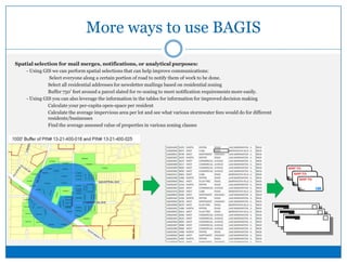
A Guide to BAGISBarrington areaGeographic information Systems
What is the purpose of the BAGIS program?MissionTo facilitate data access, promote the use of spatial technologies, and improve intergovernmental coordination on cooperative issues. To provide basic mapping and data support using local GIS resources for officials and staffTo provide training and support for local staff and officials in learning GIS Software and TechnologyTo assist villages and townships in implementing digital data standards and to help them organize and use that data.________________________________________________________________________________________Resources for members: - Access to hundreds of organized environmental, planning, political, planimetric layers of information - Mapping and Data support as well as  GIS software training for staff and officials-  Access to the BACOG Laptop with ArcMap software for member’s use. - Project support through BAGIS Maps and Data program and GIS consortium________________________________________________________________________________________FREE mapping and printing is available to each member as part of their BACOG membership.  Projects specific to a municipality or township outside basic mapping requests are handled through the GIS Consortium.  Call the BACOG office for more information or to make a request: (847) 381-7871 ________________________________________________________________________________________
What kind of information is available?GIS brings together spatial, mapped layers with tables of information, like you’d see in Excel or Access.  By overlaying information we can see patterns, manage resources, and communicate information more easily.Check out the data layers index at the end of the packet for more information about what’s available.
Accessing the information in BAGISBasic maps can be created and printed for member villages and townships:	 - BAGIS  creates, acquires, maintains , and distributes mapped information to members and data sharing partners	 - BACOG can print maps, or export maps to JPG, PDF, TIFF 	 -  BACOG can also help you with workshops and training on GIS software so you can make maps and data locally	 - Existing information can be provided, new information/projects can be requested through the GIS Consortium
More ways to use BAGISSpatial selection for mail merges, notifications, or analytical purposes:	 - Using GIS we can perform spatial selections that can help improve communications:		 Select everyone along a certain portion of road to notify them of work to be done.		Select all residential addresses for newsletter mailings based on residential zoning		Buffer 750’ feet around a parcel slated for re-zoning to meet notification requirements more easily. 	 - Using GIS you can also leverage the information in the tables for information for improved decision making		Calculate your per-capita open-space per resident		Calculate the average impervious area per lot and see what various stormwater fees would do for different 			residents/businesses		Find the average assessed value of properties in various zoning classes
BAGIS Data Sharing & AcquisitionContracts and Data Sharing:- BAGIS was created to assist in the acquisition, update, and distribution of data for the communities lying in 4 counties with    	many district boundaries.- BAGIS can help facilitate data sharing agreements for use on contractual work with village and townships (getting your engineer/dispatcher/district the appropriate information)2.      Data can be cataloged & distributed through BAGIS, specific to the needs of the agencyData-sharing agreements give access to the data3.      Staff & officials, or their engineers/contractors,  can use the mapping products, software, and data.4.      Digital Data standards can ensure CAD and GIS work done by 3rd party contractors/engineers are captured for use by the village or township.Requiring that information is submitted to your Village/Township on CDs in its NATIVE format (Excel, Access, or CAD– rather than PDF) ensures future usability and a better return-on-investment.
How do I get started?To request a PDF, JPG or TIFF map send an email to j.hoeffler@Bacog.org or call BACOG (847) 381-7871	Questions we’ll ask you:- Do you want it digitally, printed, or both?  If printed – how many prints do you need?	- Black and white? Or Color?	- What size do you want it to be?	- What content do you want on the map?		- Aerial photo, parcel lines, street labels, village/township boundary		- Look at the end of this booklet for the data layer index for a list describing major GIS layers		- Don’t see what you need?  Ask us to check into whether or not that information existsTo get started with ArcGIS Desktop	- Set up a time for training with the BACOG office	 - Most villages and townships have one license of ArcGIS Desktop received as part of a grant in 2001	 - BACOG has a laptop available with ArcMap – the software used by most GIS professionalsDo you just want to use the parcel, zoning & subdivision information in GIS for quick  reference when you have location based inquiries?   ArcExplorer – the free version of ArcMap may be the solution for you.   Call the BACOG office for more information.
So…. what’s available in GIS?The attached index describes some of the basic information available  through the BAGIS program.These include a variety of type of information that can be viewed at a variety of extents.
Basic Data Themes & TypesBase Data – Parcels, roads, addresses…Districts – Library, Fire, School, Congressional…Zoning – Zoning, Overlay Districts, Jurisdictional Boundary Agreements, Facility planning areasTerrain/Elevation – 2’ Contours, LiDAR data, NGS Benchmarks, Section-by-section TINsEnvironmental – Wetlands, Hydrography, Watersheds/Subwatersheds, GroundwaterAerial Photography  & Oblique Imagery         See the Data Layers inventory at the end of this packet for more information on available data
Map Gallery	Lots of local and regional maps already exist:Check online on our Public Map GalleryContact the BACOG office for a username and password to view the Member’s Map Gallery (where local, non-distributable map are filed)The Map Gallery links to BACOG, member’s, and community organization’s PDF and interactive maps are located.Please submit new or updated maps to BACOG by emailing a link or file to j.hoeffler@Bacog.org
Questions? Comments? Suggestions?Contact BACOG

A Guide to the BAGIS Program

  • 1.
    A Guide toBAGISBarrington areaGeographic information Systems
  • 2.
    What is thepurpose of the BAGIS program?MissionTo facilitate data access, promote the use of spatial technologies, and improve intergovernmental coordination on cooperative issues. To provide basic mapping and data support using local GIS resources for officials and staffTo provide training and support for local staff and officials in learning GIS Software and TechnologyTo assist villages and townships in implementing digital data standards and to help them organize and use that data.________________________________________________________________________________________Resources for members: - Access to hundreds of organized environmental, planning, political, planimetric layers of information - Mapping and Data support as well as GIS software training for staff and officials- Access to the BACOG Laptop with ArcMap software for member’s use. - Project support through BAGIS Maps and Data program and GIS consortium________________________________________________________________________________________FREE mapping and printing is available to each member as part of their BACOG membership. Projects specific to a municipality or township outside basic mapping requests are handled through the GIS Consortium. Call the BACOG office for more information or to make a request: (847) 381-7871 ________________________________________________________________________________________
  • 3.
    What kind ofinformation is available?GIS brings together spatial, mapped layers with tables of information, like you’d see in Excel or Access. By overlaying information we can see patterns, manage resources, and communicate information more easily.Check out the data layers index at the end of the packet for more information about what’s available.
  • 4.
    Accessing the informationin BAGISBasic maps can be created and printed for member villages and townships: - BAGIS creates, acquires, maintains , and distributes mapped information to members and data sharing partners - BACOG can print maps, or export maps to JPG, PDF, TIFF - BACOG can also help you with workshops and training on GIS software so you can make maps and data locally - Existing information can be provided, new information/projects can be requested through the GIS Consortium
  • 5.
    More ways touse BAGISSpatial selection for mail merges, notifications, or analytical purposes: - Using GIS we can perform spatial selections that can help improve communications: Select everyone along a certain portion of road to notify them of work to be done. Select all residential addresses for newsletter mailings based on residential zoning Buffer 750’ feet around a parcel slated for re-zoning to meet notification requirements more easily. - Using GIS you can also leverage the information in the tables for information for improved decision making Calculate your per-capita open-space per resident Calculate the average impervious area per lot and see what various stormwater fees would do for different residents/businesses Find the average assessed value of properties in various zoning classes
  • 6.
    BAGIS Data Sharing& AcquisitionContracts and Data Sharing:- BAGIS was created to assist in the acquisition, update, and distribution of data for the communities lying in 4 counties with many district boundaries.- BAGIS can help facilitate data sharing agreements for use on contractual work with village and townships (getting your engineer/dispatcher/district the appropriate information)2. Data can be cataloged & distributed through BAGIS, specific to the needs of the agencyData-sharing agreements give access to the data3. Staff & officials, or their engineers/contractors, can use the mapping products, software, and data.4. Digital Data standards can ensure CAD and GIS work done by 3rd party contractors/engineers are captured for use by the village or township.Requiring that information is submitted to your Village/Township on CDs in its NATIVE format (Excel, Access, or CAD– rather than PDF) ensures future usability and a better return-on-investment.
  • 7.
    How do Iget started?To request a PDF, JPG or TIFF map send an email to j.hoeffler@Bacog.org or call BACOG (847) 381-7871 Questions we’ll ask you:- Do you want it digitally, printed, or both? If printed – how many prints do you need? - Black and white? Or Color? - What size do you want it to be? - What content do you want on the map? - Aerial photo, parcel lines, street labels, village/township boundary - Look at the end of this booklet for the data layer index for a list describing major GIS layers - Don’t see what you need? Ask us to check into whether or not that information existsTo get started with ArcGIS Desktop - Set up a time for training with the BACOG office - Most villages and townships have one license of ArcGIS Desktop received as part of a grant in 2001 - BACOG has a laptop available with ArcMap – the software used by most GIS professionalsDo you just want to use the parcel, zoning & subdivision information in GIS for quick reference when you have location based inquiries? ArcExplorer – the free version of ArcMap may be the solution for you. Call the BACOG office for more information.
  • 8.
    So…. what’s availablein GIS?The attached index describes some of the basic information available through the BAGIS program.These include a variety of type of information that can be viewed at a variety of extents.
  • 9.
    Basic Data Themes& TypesBase Data – Parcels, roads, addresses…Districts – Library, Fire, School, Congressional…Zoning – Zoning, Overlay Districts, Jurisdictional Boundary Agreements, Facility planning areasTerrain/Elevation – 2’ Contours, LiDAR data, NGS Benchmarks, Section-by-section TINsEnvironmental – Wetlands, Hydrography, Watersheds/Subwatersheds, GroundwaterAerial Photography & Oblique Imagery See the Data Layers inventory at the end of this packet for more information on available data
  • 10.
    Map Gallery Lots oflocal and regional maps already exist:Check online on our Public Map GalleryContact the BACOG office for a username and password to view the Member’s Map Gallery (where local, non-distributable map are filed)The Map Gallery links to BACOG, member’s, and community organization’s PDF and interactive maps are located.Please submit new or updated maps to BACOG by emailing a link or file to j.hoeffler@Bacog.org
  • 11.