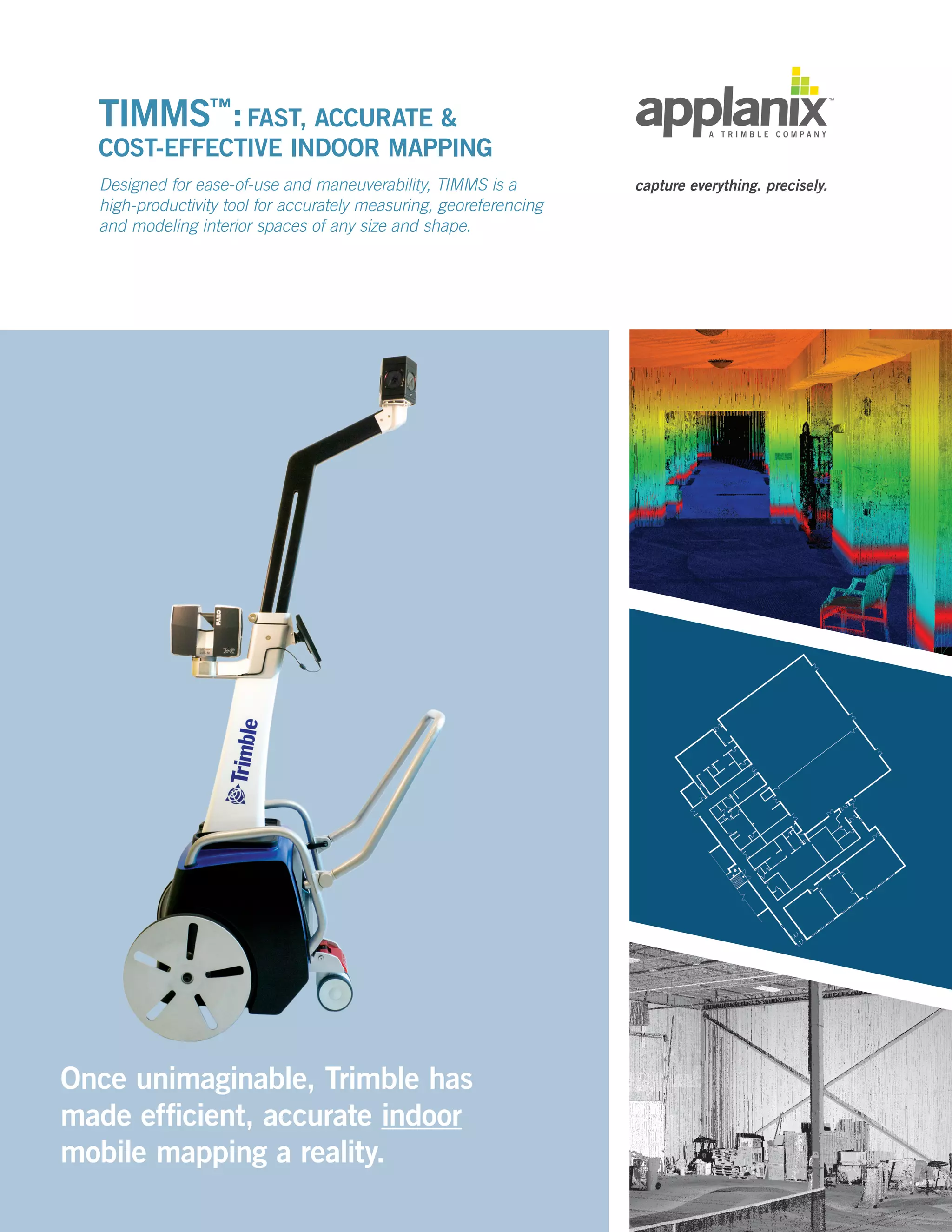
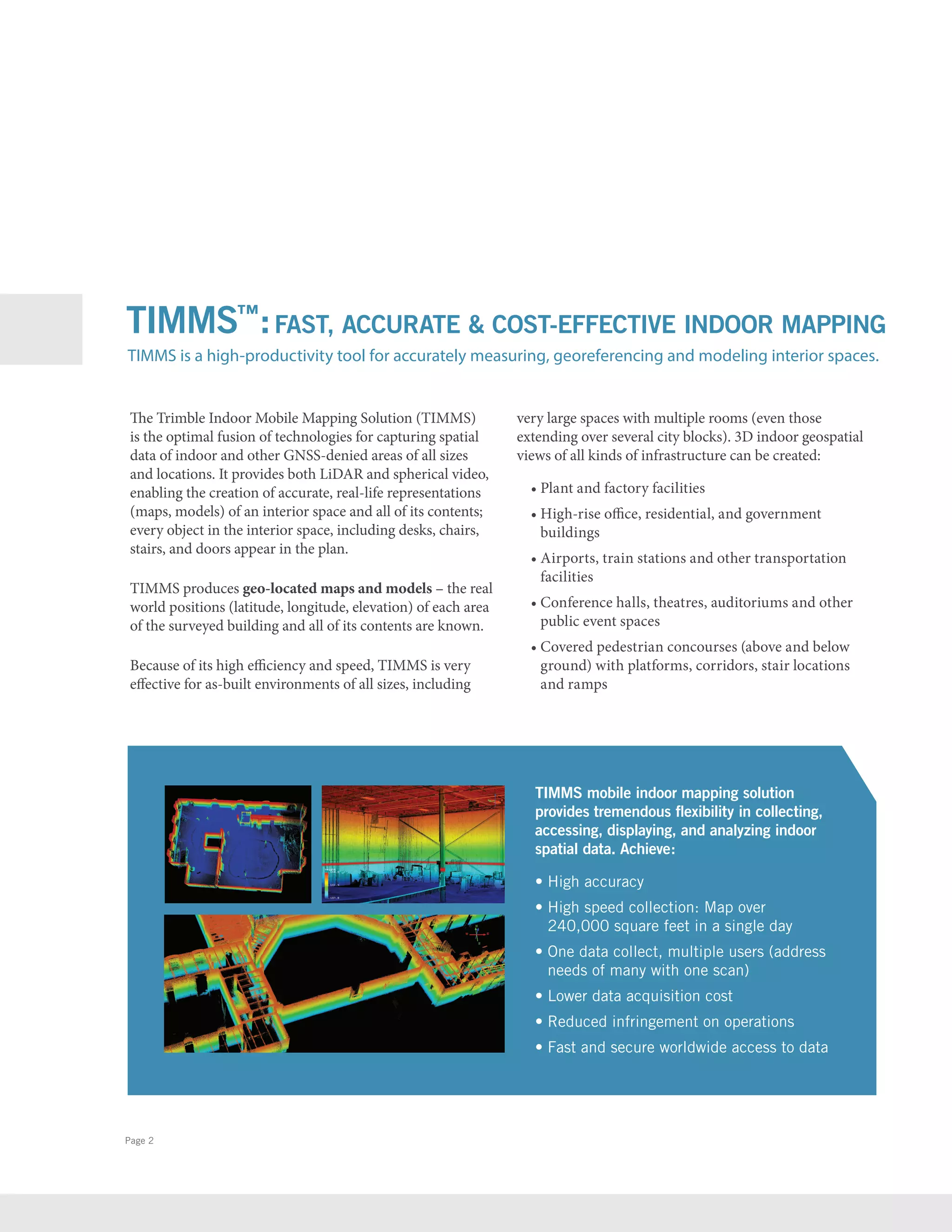
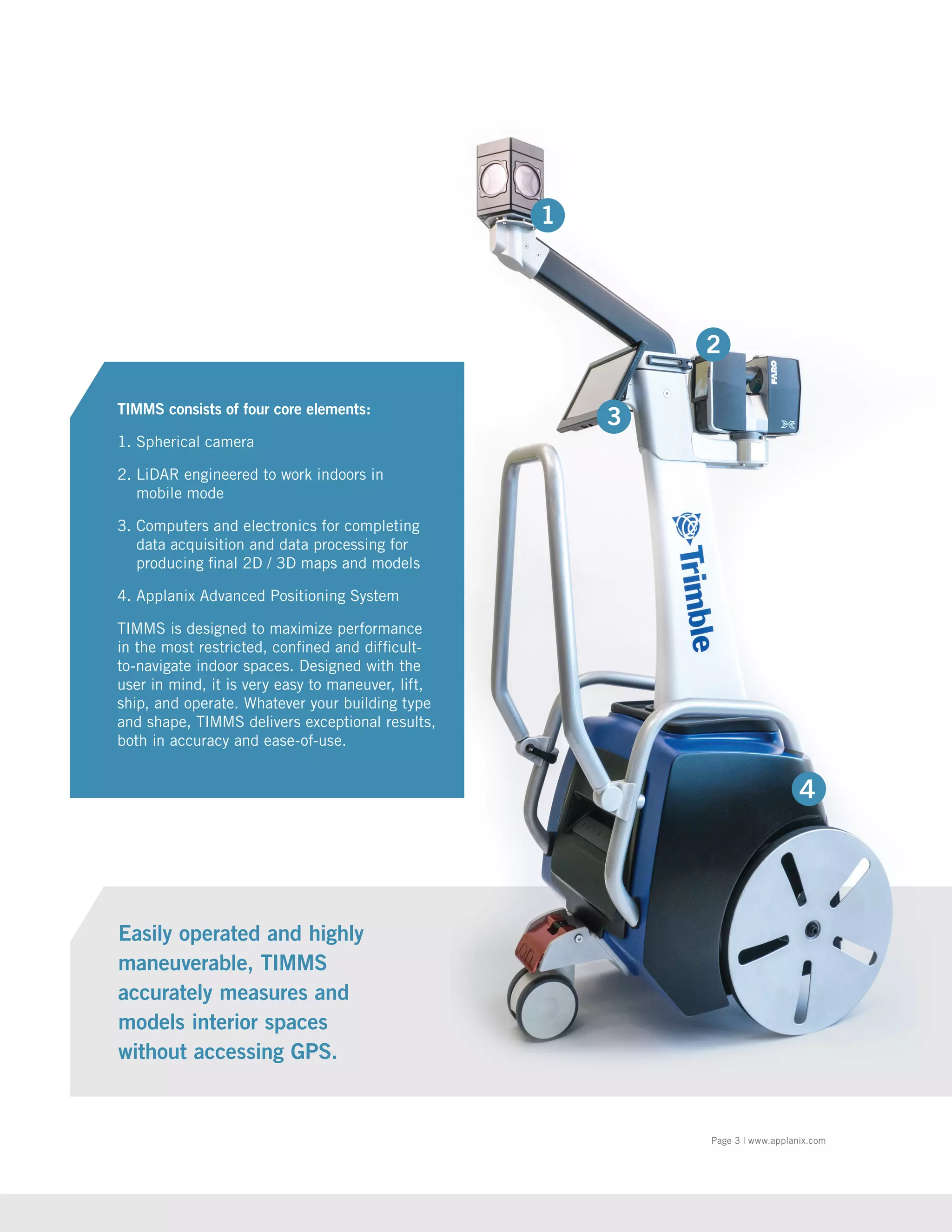
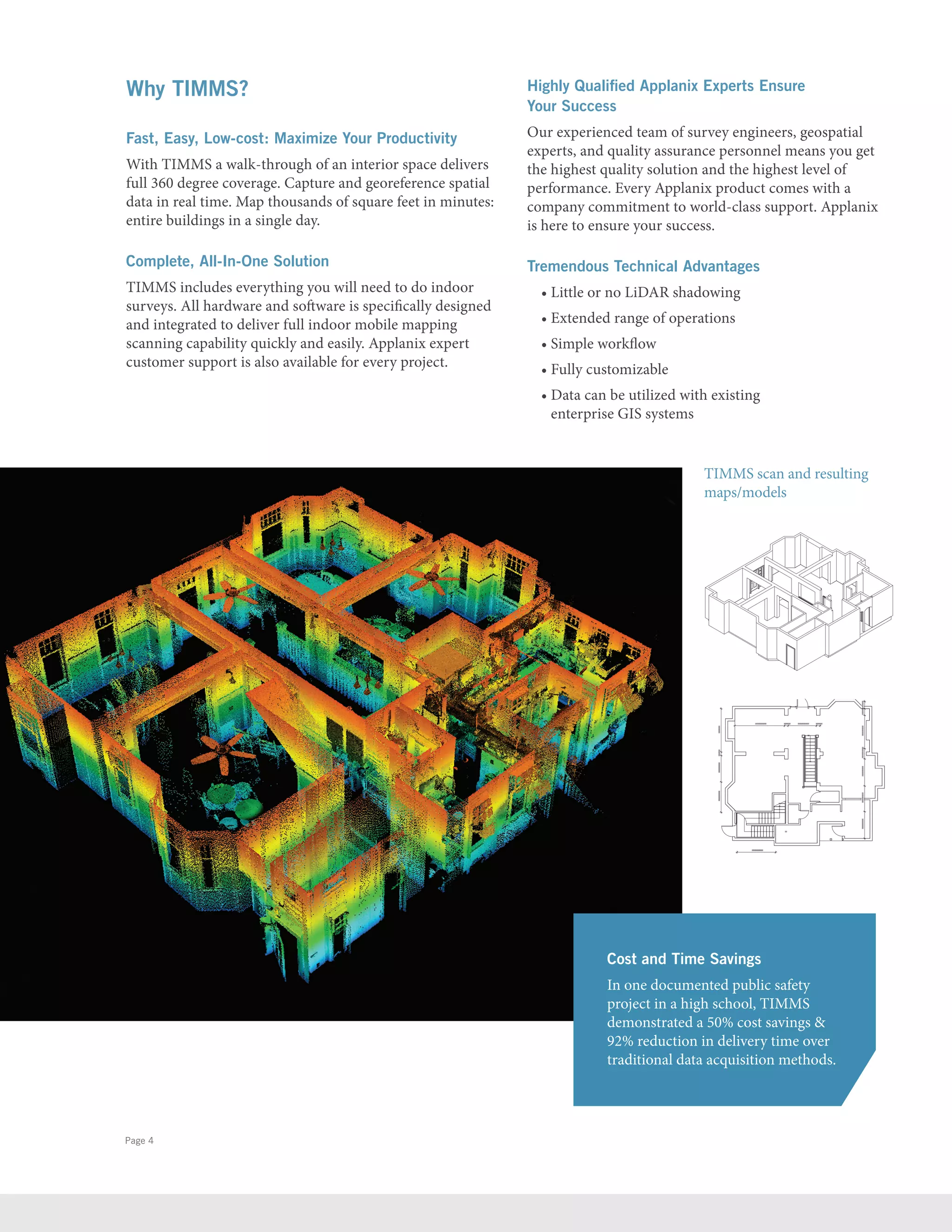
TIMMS is a high-productivity indoor mobile mapping solution that provides accurate, real-life representations of interior spaces through LiDAR and spherical video. It can map thousands of square feet in minutes and entire buildings in a single day. TIMMS produces geo-located maps and 3D models showing the real-world positions of interior areas and contents. The all-in-one system is easy to use and provides comprehensive, cost-effective indoor spatial data collection and analysis.
Facility Condition Assessment And Asset Management With GISJohn Przybyla
This document discusses using facility condition assessments and geographic information systems for asset management. It provides examples of Woolpert's experience conducting facility condition assessments for various organizations. It describes the objectives, approach, tools, and deliverables for facility condition assessments. It also explains how GIS can be used to manage and analyze facility condition assessment data, and provides examples of using GIS for infrastructure lifecycle planning and risk-based asset management.
The future of resilient construction – building information modelingnibtedu
The world of construction and infrastructure has its advantages and disadvantages. One of the most critical aspects in construction engineering is the presence of the word or phenomenon called “disaster”.
O documento fornece dicas para quem deseja ser um empreendedor de sucesso. Ele ressalta a importância de investir no que gosta, buscar capacitação constantemente, e nunca desistir, mesmo quando enfrentar obstáculos. Também enfatiza a necessidade de inovar, agir com honestidade, ser um exemplo de determinação e perseverança, correr riscos calculados, e planejar cuidadosamente os passos do empreendimento.
Es la publicación especializada en la Opinión de los empresarios sobre el comportamiento de las variables e indicadores líderes del comercio en Medellín y el Valle de Aburrá, editada por FENALCO ANTIOQUIA, para quienes saben que la información es la clave en la toma de decisiones.
Es un documento muy bien posicionado, con excelente contenido y presentación. La entrega es gratuita y sobre pedido.
Tiene la característica de ser el único boletín, en el nivel nacional y local, que incluye información del comercio interno de los establecimientos ubicados en Medellín y el Valle de Aburrá, cuyas mediciones se hacen periódicamente a muestras consideradas grandes y con una metodología estadística confiable.
Analiza la evolución de las ventas, los inventarios, los principales problemas y expectativas de los comerciantes. A partir de la información mensual que se obtiene de los 560 establecimientos y firmas encuestadas, y el indicador tradicional de lectura es el porcentaje de respuestas.
Este documento describe los cálculos realizados para preparar soluciones para una práctica de biología molecular. Explica conceptos clave sobre soluciones como solvente, soluto y concentración. Luego detalla los procedimientos y cálculos para preparar soluciones de lisis, alcalina, salina y tampón utilizando compuestos como TRIS, EDTA, glucosa y acetato de sodio. Finalmente resume los resultados y concluye que los procedimientos permitieron preparar soluciones adecuadas sin contaminación para el desarrollo de la práct
Este documento resume las investigaciones del Dr. Tony Buzan sobre los mapas mentales. Buzan se dio cuenta de que no existía una bibliografía efectiva sobre cómo mejorar el aprendizaje y aprovechar las capacidades del cerebro. Llevó a cabo investigaciones en varios países utilizando técnicas como observaciones, cuestionarios y experimentos prácticos. Uno de estos experimentos involucró pedirle a las personas que prepararan una presentación creativa sobre el cerebro en 5 minutos utilizando varios materiales. Los resultados mostraron que la gente tiende a
Mauro Libi Crestani: Avelina se hace presente en el deporte venezolano con el patrocinio al Caracas Fútbol Club y con el apoyo a la carrera-caminata Loyola 5K 2017.
Decision Support System & Group Decision Support SystemNaresh Rupareliya
This document discusses decision support systems and group decision support systems. It defines DSS as applications that help with the intelligence phase of decision making by identifying problems and potential solutions. It describes different types of DSS like status inquiry, data analysis, and model-based systems. It then discusses group decision support systems, how they allow multiple people to collaborate over networks or teleconferencing, and examples of GDSS tools and applications.
This document discusses the EU's regulatory and policy actions around automated and connected vehicles. It defines different levels of vehicle automation from driver assistance to fully autonomous. The EU is working to address challenges around legal frameworks, infrastructure, data, and liability. The GEAR 2030 initiative aims to develop a roadmap for deploying automated vehicles by 2030. Recommendations will focus on systems reaching level 3-4 automation by 2020 related to motorways and traffic. The existing regulatory framework is being reviewed to address issues like road safety, liability, data storage, and connectivity requirements. International cooperation is also occurring to harmonize regulations and research efforts.
El documento describe la importancia de la evaluación de proyectos para la asignación racional de recursos escasos y la solución de problemas económicos. Explica que la evaluación de proyectos clasifica los proyectos según su objetivo y objeto de inversión, y considera flujos de caja, costos y beneficios privados y sociales. Además, destaca que la preparación y evaluación de proyectos es una herramienta clave para la planificación del desarrollo económico de un país.
Esta empresa fornece soluções de videomonitoramento para segurança eletrônica, com equipe especializada que atende desde o planejamento até a implementação de projetos. Ela oferece produtos como gravadores móveis de vídeo e câmeras para veículos em movimento ou locais fixos.
Mg2 Group was formed through the fusion of three companies bringing together experience and innovation in marketing, advertising, and technology. The group offers full-service customized communication solutions across multiple platforms for branding, creative campaigns, and strategic digital intelligence for clients in industries such as fashion, real estate, and franchising. Key services include market analysis, branding development, advertising campaigns, digital strategies, app development, and technology solutions to improve businesses and lives.
O documento descreve um treinamento para recepcionistas com o objetivo de melhorar o atendimento ao cliente. Ele fornece dicas sobre como se portar profissionalmente, preparar-se para o atendimento, tratar bem os clientes por telefone ou pessoalmente e manter a organização da recepção. O treinamento enfatiza a importância de dar atenção ao cliente, resolver seus problemas e criar uma rotina de trabalho para uma prestação de serviço de qualidade.
Este suplemento alimenticio ayuda a reducir grasas y colesterol, mejorar la memoria, tratar la anemia, reconstruir la flora intestinal, fortalecer el sistema nervioso y combatir problemas gastrointestinales. Contiene proteínas de alta calidad y es libre de colesterol, por lo que puede consumirse por personas intolerantes a la leche de vaca. También combate la caída del cabello y controla zonas de orzuela y resequedad.
El documento describe cómo las empresas deben responder a los tiempos de crisis. Resalta la importancia de retener a los clientes existentes y robar clientes de la competencia. También enfatiza agregar valor a través de nuevas tácticas y fortalecer la marca. Finalmente, cita a un autor que argumenta que en tiempos de cambio, solo las empresas flexibles, locas e imaginativas que satisfacen las necesidades de los clientes sobrevivirán.
Un Vistazo Al Mundo De La Literatura Hispanapaulabergen
Este documento presenta una introducción a varios autores hispanos importantes. Habla sobre Miguel de Cervantes y su novela Don Quijote, la poeta chilena Gabriela Mistral y sus poemas, los premios Nobel de Literatura ganados por Mistral y Pablo Neruda, y la obra Cien Años de Soledad del autor colombiano Gabriel García Márquez.
ComEd developed a unique strategy to install nearly 100,000 smart meters across over 2000 high-rise buildings in Chicago's dense Loop district. The strategy involved a soft launch of meters in some buildings to test processes. It then established communication base stations at six substations to facilitate full deployment. ComEd worked closely with building managers, conducting walk-downs of large buildings to ensure good communication coverage before installing all meters in a building over a single appointment. This successful strategy enabled ComEd to deploy most meters within a 6-9 month window.
How innovative cutting edge technology is revolutionizing land surveying and construction. With real-world examples, we show how laser technology such as LiDAR, aerial drone 3d scanning and hyperspectral imaging. Understand how LiDAR and 3d scanning are bringing unprecedented accuracy (to the milimeter) to major construction projects, mining tunnels & shafts, buildings and roads, forensics, aerial mapping, ships and airplanes, airports, industrial manufacturing plants, and more.
What is monitoring, 4 types of monitoring solutions, What is DCIM, What a comprehensive data center infrastructure management solution provides, The true value of DCIM, 4 steps to deploy DCIM, The DCIM ultimate goal
Richard Archer discussed the application of BIM in facilities management. He explained that traditional FM uses separate software that lacks integration, while BIM allows FM teams access to consistent and useful digital information. BIM benefits FM by providing accurate, timely data to relevant parties and improving collaboration. Emerging technologies like cloud computing, mobile/RFID, augmented reality, energy sensors, and 3D printing also support FM. YouBIM was presented as a solution to extract BIM data and metadata into a cloud-based FM platform, integrating data sources and translating information to asset management systems. This allows remote equipment access and monitoring from the YouBIM model.
Know how Cygnet Infotech delivered a robust #ProjectManagement solution that addressed client's daily project planning and management challenges saving cost, manual work and time while improving efficiency.
After diving deep into the client’s business challenges, Cygnet conceptualized a Project Management Solution for effective resource allocation and added transparency in operations.
Three-dimensional (3D) laser scanning
uses light detection and ranging (LIDAR)
measurement techniques to quickly and
accurately collect data on the size and shape
of an object or environment. Through the
years, the cost to purchase and operate
stationary and mobile scanning has decreased
and is now changing the way 3D data is
captured and interpreted.
Paul Drummond, Global Monitoring Sales Manager, Trimble - Presenting at Seism...SmartNet
Seismics and the City – Creating a Greater Christchurch – Envisioning. Engaging. Energising was held on 27th March 2015, Christchurch.
Seismically Smart Buildings: Learning from the past, setting the standard for the future.
This document discusses IBM's support for facility owners through its Maximo and TRIRIGA applications. It describes the key capabilities of Maximo for asset and work management. It also outlines TRIRIGA's modules for real estate management, capital projects, facilities management, and environmental sustainability. The document advocates for improving the handover of building information from design to operations through the use of BIM and standards like COBie.
The document discusses how construction project productivity can be increased through the use of technology. It provides examples of Trimble technology solutions that help drive gains in areas like quality, safety, cost management and productivity. Specific case studies are presented covering infrastructure projects where modeling, machine control, operations execution and management solutions helped optimize planning, operations and monitoring.
Tantek Solutions is a family-run digital engineering company with over 30 years of experience in Ireland and the UK. It provides a full range of services for the architecture, engineering, construction, and operations industries. The company uses the most innovative digital technologies available and differentiates itself by providing a "one stop shop" service from design to project completion.
This document discusses several case studies of integrating facilities management and geographic information systems. It describes how Phoenix Sky Harbor International Airport developed an extensive 2D GIS dataset of interior building features collected through field surveys. It also outlines how Oakland County, Michigan implemented a GIS-centric computerized maintenance management system. Finally, it proposes a concept for the Architect of the Capitol to develop 3D GIS models from CAD floor plans and laser scans, and integrate non-spatial databases and a GIS-enabled CMMS for maintenance and space management.
This document provides a product catalog for construction tools and equipment sold by MVS. It includes sections on measuring devices, layout solutions, lasers, surveying equipment like GPS systems, scanners, robotic total stations, and accessories. The catalog describes the products in detail and provides specifications and applications. It also shares a customer testimonial about using a Trimble robotic total station for layout on a construction project.
The document discusses Durham University's plans to develop smart buildings and an intelligent campus. It outlines definitions of smart buildings and an intelligent campus. Durham University's new Teaching and Learning Centre is highlighted as a flagship smart building project implemented in partnership with SSE Enterprise. The building utilizes building energy management systems, efficient HVAC, electric vehicle charging, and on-site power generation to address challenges of sustainability, student experience, and high-level facilities. Next steps discussed include advancing convergence of technologies and initiating collaborative initiatives to develop the intelligent campus vision.
THE ENGINEERING & CONSTRUCTION SECTOR GETS BIGGER BY THE DAY,nibtedu
As discussed earlier, BIM incorporates every bit of technology, devices, and software,
it provides a great opportunity for owners, architects, cost managers,
project managers, BIM modelers, etc. to leverage software to author 3D models,
create schedules, quantity take-offs, cost-estimation, determine clashes, etc.
East Surrey College required a centralized security management system to monitor its 400+ intruder detectors from a single platform. It chose SynopSYS, which displays real-time status of security devices on intuitive maps. This allows the Facilities Manager to quickly identify and respond to alarms. SynopSYS also integrates with other building systems. The college is satisfied with SynopSYS' flexibility and technical support.
This document discusses how Building Information Modeling (BIM) and Building Information Management (BIM) can be applied throughout the entire lifecycle of a building or asset from design through operation and maintenance. It outlines how a platform called EcoDomus provides lifecycle BIM capabilities by integrating various data sources like BIM models, CMMS, CAFM, and BAS systems. The document also discusses challenges with traditional handover of information from contractors to facility managers and how EcoDomus helps address issues like defining required data, responsibilities, and processes to ensure high quality data handover.
Should I Adopt a Digital Twin? Memoori was joined by Sebastien Coulon, co-founder of SpinalCom to discuss the OT – IT Convergence challenge of moving from Automated Buildings to Digital Buildings and how Digital Twins support the Real Estate Value Chain.
1. TIMMS™
:FAST, ACCURATE &
COST-EFFECTIVE INDOOR MAPPING
Designed for ease-of-use and maneuverability, TIMMS is a
high-productivity tool for accurately measuring, georeferencing
and modeling interior spaces of any size and shape.
capture everything. precisely.
Once unimaginable, Trimble has
made efficient, accurate indoor
mobile mapping a reality.
2. The Trimble Indoor Mobile Mapping Solution (TIMMS)
is the optimal fusion of technologies for capturing spatial
data of indoor and other GNSS-denied areas of all sizes
and locations. It provides both LiDAR and spherical video,
enabling the creation of accurate, real-life representations
(maps, models) of an interior space and all of its contents;
every object in the interior space, including desks, chairs,
stairs, and doors appear in the plan.
TIMMS produces geo-located maps and models – the real
world positions (latitude, longitude, elevation) of each area
of the surveyed building and all of its contents are known.
Because of its high efficiency and speed, TIMMS is very
effective for as-built environments of all sizes, including
very large spaces with multiple rooms (even those
extending over several city blocks). 3D indoor geospatial
views of all kinds of infrastructure can be created:
• Plant and factory facilities
• High-rise office, residential, and government
buildings
• Airports, train stations and other transportation
facilities
• Conference halls, theatres, auditoriums and other
public event spaces
• Covered pedestrian concourses (above and below
ground) with platforms, corridors, stair locations
and ramps
TIMMS is a high-productivity tool for accurately measuring, georeferencing and modeling interior spaces.
TIMMS mobile indoor mapping solution
provides tremendous flexibility in collecting,
accessing, displaying, and analyzing indoor
spatial data. Achieve:
• High accuracy
• High speed collection: Map over
240,000 square feet in a single day
• One data collect, multiple users (address
needs of many with one scan)
• Lower data acquisition cost
• Reduced infringement on operations
• Fast and secure worldwide access to data
Page 2
TIMMS™
:FAST, ACCURATE COST-EFFECTIVE INDOOR MAPPING
3. Page 3 | www.applanix.com
Easily operated and highly
maneuverable, TIMMS
accurately measures and
models interior spaces
without accessing GPS.
TIMMS consists of four core elements:
1. Spherical camera
2. LiDAR engineered to work indoors in
mobile mode
3. Computers and electronics for completing
data acquisition and data processing for
producing final 2D / 3D maps and models
4. Applanix Advanced Positioning System
TIMMS is designed to maximize performance
in the most restricted, confined and difficult-
to-navigate indoor spaces. Designed with the
user in mind, it is very easy to maneuver, lift,
ship, and operate. Whatever your building type
and shape, TIMMS delivers exceptional results,
both in accuracy and ease-of-use.
1
4. Page 4
Why TIMMS?
Fast, Easy, Low-cost: Maximize Your Productivity
With TIMMS a walk-through of an interior space delivers
full 360 degree coverage. Capture and georeference spatial
data in real time. Map thousands of square feet in minutes:
entire buildings in a single day.
Complete, All-In-One Solution
TIMMS includes everything you will need to do indoor
surveys. All hardware and software is specifically designed
and integrated to deliver full indoor mobile mapping
scanning capability quickly and easily. Applanix expert
customer support is also available for every project.
Highly Qualified Applanix Experts Ensure
Your Success
Our experienced team of survey engineers, geospatial
experts, and quality assurance personnel means you get
the highest quality solution and the highest level of
performance. Every Applanix product comes with a
company commitment to world-class support. Applanix
is here to ensure your success.
Tremendous Technical Advantages
• Little or no LiDAR shadowing
• Extended range of operations
• Simple workflow
• Fully customizable
• Data can be utilized with existing
enterprise GIS systems
Cost and Time Savings
In one documented public safety
project in a high school, TIMMS
demonstrated a 50% cost savings
92% reduction in delivery time over
traditional data acquisition methods.
TIMMS scan and resulting
maps/models
5. TIMMS Applications: Turning Data into Decision-Ready Intelligence
Rapid Response / Public Safety / Law Enforcement
Accurate and up to date spatial information of public
buildings offers many safety benefits to responders and
to the public:
• Detailed 360 degree imagery provides responders
with total situational awareness before entering.
Layout and contents are fully known, meaning
no surprises.
• Data is available through the internet behind your
own firewall to multiple decision makers in multiple
locations, enabling informed decisions.
• Data enables detailed preparation and training
for specific buildings / areas.
Commercial Building Management / Space
Utilization / Planning Design
By quickly and accurately determining the current
“as-built” layout and dimensions of existing buildings,
TIMMS delivers critical intelligence for building
management including managing security issues, health
and safety concerns, maintenance, modernization and
restoration planning, and space utilization.
Because of its high efficiency and speed, TIMMS is very
effective for built environments of all sizes, including
very large areas extending over several city blocks
such as malls and underground concourses. This
enables pedestrian traffic planning, retail concession
management, and base mapping for location-based
services of all types.
As-Built Modeling
Increasingly 3D models, 2D floor plans, and Computer
Aided Design (CAD) are being used to increase
productivity in building design, construction, and
maintenance. TIMMS generated interior spatial data –
including building geometry, spatial relationships and
geographic information –facilitates the production of
such models. For Owners/Facility Managers, these jobs
can lead to short and long term operational savings.
6. Page 6
St. Mary’s University College in Calgary was relocated to
the historic Father Lacombe Centre in 1999. The site has
undergone extensive construction and renovation since
then, most recently with the full renovation of the school’s
gymnasium into a brand new athletics centre. The campus
includes several heritage buildings that require ongoing
preservation and documentation.
Building Documentation Needed: The many recent
changes, coupled with the historic nature of the site, meant
that comprehensive and up-to-date plans and blueprints
for most of the buildings simply did not exist. St. Mary’s
required up-to-date building plans that could be used for
campus navigation, safety and emergency planning, and
space allocation.
Solution: InView Solutions, Ltd. used Trimble’s Indoor
Mobile Mapping System (TIMMS) to provide the needed
data. The InView team scanned six major structures on
the St. Mary’s University College Campus in just 20 hours.
From these initial scans, the team created a total of 14 floor
plans to cover all buildings, as well as a full campus virtual
tour. The team later performed a second scan once the
renovations in the new fitness centre were completed.
This dataset was integrated with the original scan to
provide a completely updated model, as well as a before/
after virtual panorama of the facility. The entire process
– from data collection to the production of complete
digital models of the entire campus – took just 55 hours
to complete at a cost saving of over 50% compared to
traditional static methods.
Case Studies
3-Dimensional Indoor Coverage for 50% Less Than Static
Methods at St Mary’s
7. Public Safety: TIMMS Reduces
Cost by More Than 50% and
Time-to-Completion by More
Than 80%
Emergency Planning and Emergency Response are two
important aspects of overall school safety and security,
but both are difficult to act upon without up-to-date and
accurate indoor layout information. Because accurate
blueprints of Northwood-Kensett High School of Worth
County, Iowa were non-existent, first responders were
faced with entering the building “blind” to its structure and
layout, and unsure of where to go and what path to take.
The Challenge: Officials required an easy to use and
highly accurate digital blueprint of the entire school,
with exact distances and measurements of every single
room, closet, hallway and doorway in the structure to
facilitate public safety
The Solution: A simple walk-through with TIMMS of
the school is all it took to achieve full 360 degree indoor
coverage. Georeferenced spatial data was captured
accurately and quickly as the mobile system moved
through the building. Maps and models, covering all
75,000 sq ft in all 90 rooms of the inside of the building,
were created. Scanning took just 5 hours.
Results: Enormous Cost and Time Savings: TIMMS
final product was delivered in 92% less time than static
methods, and the cost of using TIMMS to the school was
50% lower as well.
Page 7 | www.applanix.com
Floor plan created for
Applanix HQ cubicle
TIMMS – 3D LiDAR Based
Model of Philadelphia
Subway Concourse
TIMMS – Spherical
Video of an underground
concourse
The Old Don Jail in Toronto
– All Ceiling Beams/Joists
Observed