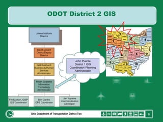
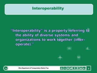
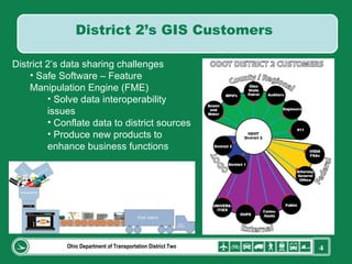
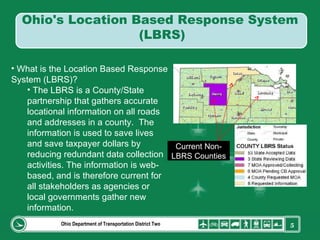
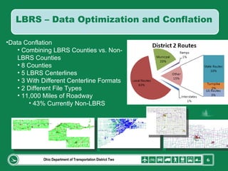
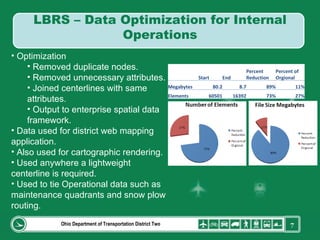
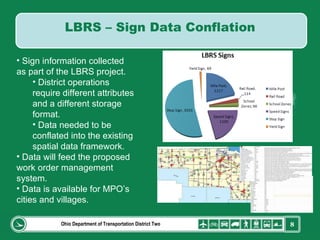
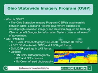
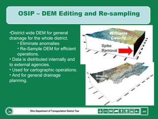
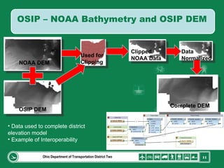
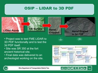
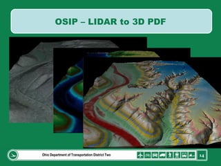
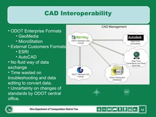
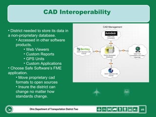
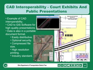
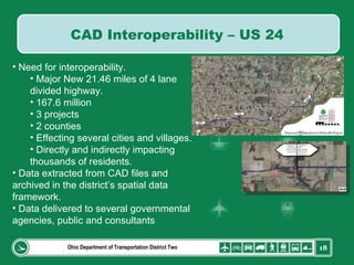
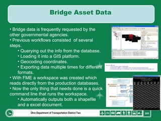
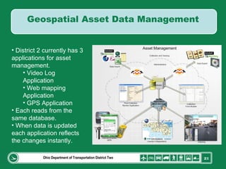
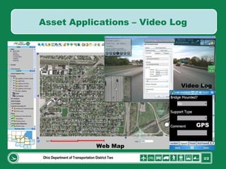
GIS-T 2010 Building a Successful Geospatial Data Sharing Framework: A Ohio DOT Success Story
Ohio Department of Transportation District Two John Puente District 1 GIS Coordinator\ Planning Administrator ODOT District 2 GIS
Ohio Department of Transportation District Two Interoperability
Ohio Department of Transportation District Two District 2’s data sharing challenges Safe Software – Feature Manipulation Engine (FME) Solve data interoperability issues Conflate data to district sources Produce new products to enhance business functions District 2’s GIS Customers
Ohio Department of Transportation District Two What is the Location Based Response System (LBRS)? The LBRS is a County/State partnership that gathers accurate locational information on all roads and addresses in a county.  The information is used to save lives and save taxpayer dollars by reducing redundant data collection activities. The information is web-based, and is therefore current for all stakeholders as agencies or local governments gather new information.  Current Non-LBRS Counties Ohio's Location Based Response System  (LBRS)
Ohio Department of Transportation District Two Data Conflation Combining LBRS Counties vs. Non-LBRS Counties 8 Counties 5 LBRS Centerlines 3 With Different Centerline Formats 2 Different File Types 11,000 Miles of Roadway 43% Currently Non-LBRS LBRS – Data Optimization and Conflation
Ohio Department of Transportation District Two Optimization Removed duplicate nodes. Removed unnecessary attributes. Joined centerlines with same attributes. Output to enterprise spatial data framework. Data used for district web mapping application. Also used for cartographic rendering. Used anywhere a lightweight centerline is required. Used to tie Operational data such as maintenance quadrants and snow plow routing. LBRS – Data Optimization for Internal Operations   Start End Percent Reduction Percent of Orgional Megabytes 80.2 8.7 89% 11% Elements 60501 16392 73% 27%
Ohio Department of Transportation District Two Sign information collected  as part of the LBRS project. District operations require different attributes and a different storage format. Data needed to be conflated into the existing spatial data framework. Data will feed the proposed work order management system. Data is available for MPO’s cities and villages.  LBRS – Sign Data Conflation
Ohio Department of Transportation District Two What is OSIP? The Ohio Statewide Imagery Program (OSIP) is a partnership between State, Local and Federal government agencies to develop high-resolution imagery and elevation data for the State of Ohio to benefit Geographic Information System users at all levels of government. OSIP Products 1FT Color Orthophotography in GeoTIFF and MrSID format 2.5FT DEM in ArcInfo GRID and ASCII grid format, 2M LiDAR postings in LAS format  Optional 6IN Color Orthophotography 2FT and 5FT contours 1M Color Infrared photography.  Ohio Statewide Imagery Program (OSIP)
Ohio Department of Transportation District Two Spike Removal Williams County Williams County District wide DEM for general drainage for the whole district. Eliminate anomalies Re-Sample DEM for efficient operations. Data is distributed internally and to external agencies. Used for cartographic operations. And for general drainage planning. OSIP – DEM Editing and Re-sampling
Ohio Department of Transportation District Two OSIP DEM NOAA DEM Used for Clipping Clipped  NOAA Data Data Normalized  Complete DEM Data used to complete district elevation model Example of Interoperability OSIP – NOAA Bathymetry and OSIP DEM
Ohio Department of Transportation District Two OSIP – NOAA Bathymetry and OSIP DEM
Ohio Department of Transportation District Two LIDAR Points TIN Surface Aerial Cropped Aerial Draped in 3d PDF Project was to test FME LIDAR to 3D PDF functionally and to test the 3d PDF itself. Site was SR 350 at the fort ancient historical site. Final data was delivered to an archeologist working on the site. OSIP – LIDAR to 3D PDF
Ohio Department of Transportation District Two OSIP – LIDAR to 3D PDF
Ohio Department of Transportation District Two ODOT Enterprise Formats GeoMedia MicroStation External Customers Formats ESRI AutoCAD No fluid way of data exchange Time wasted on troubleshooting and data editing to convert data. Uncertainty on changes of standards by ODOT central office. CAD Interoperability
Ohio Department of Transportation District Two District needed to store its data in a non-proprietary database. Accessed in other software products. Web Viewers Custom Reports GPS Units Custom Applications Choose Safe Software’s FME application. Move proprietary cad formats to open sources Insure the district can change no matter how standards change. CAD Interoperability
Ohio Department of Transportation District Two Example of CAD interoperability. CAD to GIS Software for high quality presentations. Data is also in a portable document format. Easily distributive. Optional security. Compressed file size. High resolution printing. Industry standard. CAD Interoperability - Court Exhibits And Public Presentations
Ohio Department of Transportation District Two Need for interoperability. Major New 21.46 miles of 4 lane divided highway.  167.6 million 3 projects 2 counties Effecting several cities and villages. Directly and indirectly impacting thousands of residents. Data extracted from CAD files and archived in the district’s spatial data framework. Data delivered to several governmental agencies, public and consultants CAD Interoperability – US 24
Ohio Department of Transportation District Two ODOT Business Plan Strategy #4: Investing where it counts.  Develop sustainable revenue sources for the entire transportation system and balance investments that preserve and maintain existing assets with those that enhance system capacity. ODOT District 2 is a leader in asset management for several areas. Asset Management
Ohio Department of Transportation District Two Bridge data is frequently requested by the other governmental agencies. Previous workflows consisted  of several steps. Querying out the info from the database. Loading it into a GIS platform. Geocoding coordinates. Exporting data multiple times for different formats. With FME a workspace was created which reads directly from the production databases. Now the only thing that needs done is a quick command line that runs the workspace. Automatically outputs both a shapefile and a excel document. Bridge Asset Data
Ohio Department of Transportation District Two District 2 currently has 3 applications for asset management. Video Log Application Web mapping Application GPS Application Each reads from the same database. When data is updated each application reflects the changes instantly. Geospatial Asset Data Management
Ohio Department of Transportation District Two Web Map Video Log GPS Asset Applications – Video Log
Ohio Department of Transportation District Two Current With advanced interoperability software ODOT district 2 is able to deal with the ever changing GIS technology. Conflate different standards. Retain the enterprise data formats. Supply its customers with the format they require for their system. Automate tasks that would have taken much more time to complete. Future Use FME Server to allow our end-users to upload or download any format they require from a web based form. Implement  ARCServer and publish services for frequent requests. Conclusion
Ohio Department of Transportation District Two Contact Info Fred Judson, GISP ODOT GIS Coordinator [email_address] Thank You Questions

2010 Gist

  • 1.
    GIS-T 2010 Buildinga Successful Geospatial Data Sharing Framework: A Ohio DOT Success Story
  • 2.
    Ohio Department ofTransportation District Two John Puente District 1 GIS Coordinator\ Planning Administrator ODOT District 2 GIS
  • 3.
    Ohio Department ofTransportation District Two Interoperability
  • 4.
    Ohio Department ofTransportation District Two District 2’s data sharing challenges Safe Software – Feature Manipulation Engine (FME) Solve data interoperability issues Conflate data to district sources Produce new products to enhance business functions District 2’s GIS Customers
  • 5.
    Ohio Department ofTransportation District Two What is the Location Based Response System (LBRS)? The LBRS is a County/State partnership that gathers accurate locational information on all roads and addresses in a county. The information is used to save lives and save taxpayer dollars by reducing redundant data collection activities. The information is web-based, and is therefore current for all stakeholders as agencies or local governments gather new information. Current Non-LBRS Counties Ohio's Location Based Response System (LBRS)
  • 6.
    Ohio Department ofTransportation District Two Data Conflation Combining LBRS Counties vs. Non-LBRS Counties 8 Counties 5 LBRS Centerlines 3 With Different Centerline Formats 2 Different File Types 11,000 Miles of Roadway 43% Currently Non-LBRS LBRS – Data Optimization and Conflation
  • 7.
    Ohio Department ofTransportation District Two Optimization Removed duplicate nodes. Removed unnecessary attributes. Joined centerlines with same attributes. Output to enterprise spatial data framework. Data used for district web mapping application. Also used for cartographic rendering. Used anywhere a lightweight centerline is required. Used to tie Operational data such as maintenance quadrants and snow plow routing. LBRS – Data Optimization for Internal Operations   Start End Percent Reduction Percent of Orgional Megabytes 80.2 8.7 89% 11% Elements 60501 16392 73% 27%
  • 8.
    Ohio Department ofTransportation District Two Sign information collected as part of the LBRS project. District operations require different attributes and a different storage format. Data needed to be conflated into the existing spatial data framework. Data will feed the proposed work order management system. Data is available for MPO’s cities and villages. LBRS – Sign Data Conflation
  • 9.
    Ohio Department ofTransportation District Two What is OSIP? The Ohio Statewide Imagery Program (OSIP) is a partnership between State, Local and Federal government agencies to develop high-resolution imagery and elevation data for the State of Ohio to benefit Geographic Information System users at all levels of government. OSIP Products 1FT Color Orthophotography in GeoTIFF and MrSID format 2.5FT DEM in ArcInfo GRID and ASCII grid format, 2M LiDAR postings in LAS format Optional 6IN Color Orthophotography 2FT and 5FT contours 1M Color Infrared photography. Ohio Statewide Imagery Program (OSIP)
  • 10.
    Ohio Department ofTransportation District Two Spike Removal Williams County Williams County District wide DEM for general drainage for the whole district. Eliminate anomalies Re-Sample DEM for efficient operations. Data is distributed internally and to external agencies. Used for cartographic operations. And for general drainage planning. OSIP – DEM Editing and Re-sampling
  • 11.
    Ohio Department ofTransportation District Two OSIP DEM NOAA DEM Used for Clipping Clipped NOAA Data Data Normalized Complete DEM Data used to complete district elevation model Example of Interoperability OSIP – NOAA Bathymetry and OSIP DEM
  • 12.
    Ohio Department ofTransportation District Two OSIP – NOAA Bathymetry and OSIP DEM
  • 13.
    Ohio Department ofTransportation District Two LIDAR Points TIN Surface Aerial Cropped Aerial Draped in 3d PDF Project was to test FME LIDAR to 3D PDF functionally and to test the 3d PDF itself. Site was SR 350 at the fort ancient historical site. Final data was delivered to an archeologist working on the site. OSIP – LIDAR to 3D PDF
  • 14.
    Ohio Department ofTransportation District Two OSIP – LIDAR to 3D PDF
  • 15.
    Ohio Department ofTransportation District Two ODOT Enterprise Formats GeoMedia MicroStation External Customers Formats ESRI AutoCAD No fluid way of data exchange Time wasted on troubleshooting and data editing to convert data. Uncertainty on changes of standards by ODOT central office. CAD Interoperability
  • 16.
    Ohio Department ofTransportation District Two District needed to store its data in a non-proprietary database. Accessed in other software products. Web Viewers Custom Reports GPS Units Custom Applications Choose Safe Software’s FME application. Move proprietary cad formats to open sources Insure the district can change no matter how standards change. CAD Interoperability
  • 17.
    Ohio Department ofTransportation District Two Example of CAD interoperability. CAD to GIS Software for high quality presentations. Data is also in a portable document format. Easily distributive. Optional security. Compressed file size. High resolution printing. Industry standard. CAD Interoperability - Court Exhibits And Public Presentations
  • 18.
    Ohio Department ofTransportation District Two Need for interoperability. Major New 21.46 miles of 4 lane divided highway. 167.6 million 3 projects 2 counties Effecting several cities and villages. Directly and indirectly impacting thousands of residents. Data extracted from CAD files and archived in the district’s spatial data framework. Data delivered to several governmental agencies, public and consultants CAD Interoperability – US 24
  • 19.
    Ohio Department ofTransportation District Two ODOT Business Plan Strategy #4: Investing where it counts. Develop sustainable revenue sources for the entire transportation system and balance investments that preserve and maintain existing assets with those that enhance system capacity. ODOT District 2 is a leader in asset management for several areas. Asset Management
  • 20.
    Ohio Department ofTransportation District Two Bridge data is frequently requested by the other governmental agencies. Previous workflows consisted of several steps. Querying out the info from the database. Loading it into a GIS platform. Geocoding coordinates. Exporting data multiple times for different formats. With FME a workspace was created which reads directly from the production databases. Now the only thing that needs done is a quick command line that runs the workspace. Automatically outputs both a shapefile and a excel document. Bridge Asset Data
  • 21.
    Ohio Department ofTransportation District Two District 2 currently has 3 applications for asset management. Video Log Application Web mapping Application GPS Application Each reads from the same database. When data is updated each application reflects the changes instantly. Geospatial Asset Data Management
  • 22.
    Ohio Department ofTransportation District Two Web Map Video Log GPS Asset Applications – Video Log
  • 23.
    Ohio Department ofTransportation District Two Current With advanced interoperability software ODOT district 2 is able to deal with the ever changing GIS technology. Conflate different standards. Retain the enterprise data formats. Supply its customers with the format they require for their system. Automate tasks that would have taken much more time to complete. Future Use FME Server to allow our end-users to upload or download any format they require from a web based form. Implement ARCServer and publish services for frequent requests. Conclusion
  • 24.
    Ohio Department ofTransportation District Two Contact Info Fred Judson, GISP ODOT GIS Coordinator [email_address] Thank You Questions