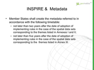
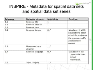
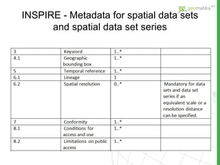
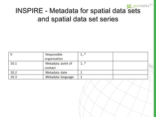
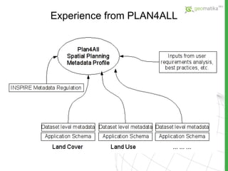
Metadata Karel Janecka, Karel Charvat Department of Mathematics, Faculty of applied Sciences University of West Bohemia Pilsen, Czech Republic kjanecka @ kma.zcu.cz Help Service Remote Sensing charvat @ccss.cz
Agenda Metadata – what is it? About the role of metadata in SDI INSPIRE  &  Metadata Experience from european projects
Metadata – what is it? Metadata is data about data  …  and is a vital component of spatial data.
Metadata – what is it? Metadata shall also include information on the following : the conformity of spatial data sets with the implementing rules conditions applying to access to, and use of, spatial data sets and services and, where applicable, corresponding fees the validity of spatial data sets the public authorities responsible for the establishment,  management, maintenance and distribution of spatial data  sets and services limitations on public access and the reasons for such  limitations
SDI  & Metadata Spatial Data Infrastructure (SDI) is an enabling platform that facilities access to spatial data and sharing spatial resources and tools among different practitioners Metadata play a key role in any spatial data infrastructure initiative  It provides users of spatial data with information about the purpose, quality, actuality and accuracy and many more of spatial datasets.
INSPIRE  &  Metadata The  INSPIRE “Metadata Regulation ” is mandatory for all spatial data themes of the INSPIRE Directive Annexes.  The INSPIRE document  “Technical Guidelines based on EN ISO 19115 and EN ISO 19119 (Revised edition) ” provides technical guidelines for the implementation of the INSPIRE Metadata Regulation The document compares the core requirements of ISO 19115 against those of INSPIRE  the conformance to ISO 19115 does not guarantee the conformance to INSPIRE .
INSPIRE  &  Metadata Member States shall ensure that metadata are created for the spatial data sets and services corresponding to the themes listed in Annexes I, II and III, and that those metadata are kept  up to date.
INSPIRE  &  Metadata Member States shall create the metadata referred to in accordance with the following timetable: not later than two years after the date of adoption of implementing rules in the case of the spatial data sets corresponding to the themes listed in Annexes I and II; not later than five years after the date of adoption of implementing rules in the case of the spatial data sets corresponding to the  themes  listed in Annex III.
INSPIRE  -  Metadata for spatial data sets and spatial data set series
INSPIRE  -  Metadata for spatial data services
Experience from PLAN4ALL The main goal of the Plan4all project is the implementation of the INSPIRE Directive into spatial planning processes. Metadata profile is one of the important Plan4all outputs. On the metadata level the project will focus on metadata profiles for the following spatial data themes:  Land Cover Land Use Utility and Government Services Production and Industrial Facilities Agricultural and Aquaculture Facilities Area Management/Restriction/Regulation Zones and Reporting Units Natural Risk Zones.
Experience from PLAN4ALL As far as metadata are concerned, Plan4all will work on two levels: on the one hand INSPIRE requirements claim for the definition of metadata elements on dataset level, for each spatial data theme, in addition to the mandatory metadata elements set of the INSPIRE Metadata Regulation on the other hand a main objective of the project is the definition of an overall spatial planning metadata profile derived from the metadata profiles on dataset level.
Experience from PLAN4ALL
Thank you for your attention! Karel Janecka , Karel Charvat Department of Mathematics, Faculty of applied Sciences University of West Bohemia Pilsen, Czech Republic kjanecka @ kma.zcu.cz Help Service Remote Sensing charvat @ccss.cz

03 --metadata

  • 1.
    Metadata Karel Janecka,Karel Charvat Department of Mathematics, Faculty of applied Sciences University of West Bohemia Pilsen, Czech Republic kjanecka @ kma.zcu.cz Help Service Remote Sensing charvat @ccss.cz
  • 2.
    Agenda Metadata –what is it? About the role of metadata in SDI INSPIRE & Metadata Experience from european projects
  • 3.
    Metadata – whatis it? Metadata is data about data … and is a vital component of spatial data.
  • 4.
    Metadata – whatis it? Metadata shall also include information on the following : the conformity of spatial data sets with the implementing rules conditions applying to access to, and use of, spatial data sets and services and, where applicable, corresponding fees the validity of spatial data sets the public authorities responsible for the establishment, management, maintenance and distribution of spatial data sets and services limitations on public access and the reasons for such limitations
  • 5.
    SDI &Metadata Spatial Data Infrastructure (SDI) is an enabling platform that facilities access to spatial data and sharing spatial resources and tools among different practitioners Metadata play a key role in any spatial data infrastructure initiative It provides users of spatial data with information about the purpose, quality, actuality and accuracy and many more of spatial datasets.
  • 6.
    INSPIRE & Metadata The INSPIRE “Metadata Regulation ” is mandatory for all spatial data themes of the INSPIRE Directive Annexes. The INSPIRE document “Technical Guidelines based on EN ISO 19115 and EN ISO 19119 (Revised edition) ” provides technical guidelines for the implementation of the INSPIRE Metadata Regulation The document compares the core requirements of ISO 19115 against those of INSPIRE the conformance to ISO 19115 does not guarantee the conformance to INSPIRE .
  • 7.
    INSPIRE & Metadata Member States shall ensure that metadata are created for the spatial data sets and services corresponding to the themes listed in Annexes I, II and III, and that those metadata are kept up to date.
  • 8.
    INSPIRE & Metadata Member States shall create the metadata referred to in accordance with the following timetable: not later than two years after the date of adoption of implementing rules in the case of the spatial data sets corresponding to the themes listed in Annexes I and II; not later than five years after the date of adoption of implementing rules in the case of the spatial data sets corresponding to the themes listed in Annex III.
  • 9.
    INSPIRE - Metadata for spatial data sets and spatial data set series
  • 10.
    INSPIRE - Metadata for spatial data sets and spatial data set series
  • 11.
    INSPIRE - Metadata for spatial data sets and spatial data set series
  • 12.
    INSPIRE - Metadata for spatial data services
  • 13.
    INSPIRE - Metadata for spatial data services
  • 14.
    Experience from PLAN4ALLThe main goal of the Plan4all project is the implementation of the INSPIRE Directive into spatial planning processes. Metadata profile is one of the important Plan4all outputs. On the metadata level the project will focus on metadata profiles for the following spatial data themes: Land Cover Land Use Utility and Government Services Production and Industrial Facilities Agricultural and Aquaculture Facilities Area Management/Restriction/Regulation Zones and Reporting Units Natural Risk Zones.
  • 15.
    Experience from PLAN4ALLAs far as metadata are concerned, Plan4all will work on two levels: on the one hand INSPIRE requirements claim for the definition of metadata elements on dataset level, for each spatial data theme, in addition to the mandatory metadata elements set of the INSPIRE Metadata Regulation on the other hand a main objective of the project is the definition of an overall spatial planning metadata profile derived from the metadata profiles on dataset level.
  • 16.
  • 17.
    Thank you foryour attention! Karel Janecka , Karel Charvat Department of Mathematics, Faculty of applied Sciences University of West Bohemia Pilsen, Czech Republic kjanecka @ kma.zcu.cz Help Service Remote Sensing charvat @ccss.cz