Halfmoon Exit 9 Linkage Study
•
1 like•1,004 views

The purpose of this study is to develop a comprehensive Corridor Improvement Plan (“Plan”) for the Towns of Clifton Park and Halfmoon, in addition to improving the integration of land use and transportation in the area. Collectively, these improvements will create a sense of place and identity for both Towns in a pedestrian friendly, mixed use environment.

Recommended
Recommended
More Related Content
What's hot
Similar to Halfmoon Exit 9 Linkage Study
Similar to Halfmoon Exit 9 Linkage Study (20)
More from Nelson Ronsvalle
More from Nelson Ronsvalle (20)
Recently uploaded
Recently uploaded (20)
Halfmoon Exit 9 Linkage Study
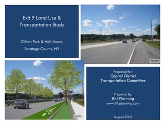
- 1. Exit 9 Land Use & Transportation Study Clifton Park & Half Moon, Saratoga County, NY BEFORE Prepared for: Capital District Transportation Committee Prepared by: BFJ Planning www.BFJplanning.com AFTER August 2008
- 2. Exit 9 Land Use & Transportation Study Clifton Park & Half Moon, Saratoga County, NY Prepared for: Capital District Transportation Committee One Park Place Albany, NY 12205 Prepared by: BFJ Planning 115 Fifth Avenue New York, NY www.BFJplanning.com August 2008
- 3. EXIT 9 LAND USE AND TRANSPORTATION STUDY Table of Contents 1. INTRODUCTION 1 1.1 Study Vision 1 1.2 Study Goals and Objectives 3 2. EXISTING CONDITIONS 5 2.1 Land Use 6 2.2 Zoning 8 2.3 Demographics 11 2.4 Ethnic Characteristics and Social Justice 17 2.5 Transportation 20 3. GENERAL CONCEPTS AND GUIDING PRINCIPLES FOR FUTURE 30 3.1 Connect Land Use and Transportation Decisions 30 3.2 Sustainable Land Use Planning 31 3.3 Complete Streets (CS) 32 3.4 Rethinking Parking 36 3.5 Enhanced Design Standards and Design Guidelines 36 4. RECOMMENDED IMPROVEMENT STRATEGIES 38 4.1 Transportation Strategies 38 4.1.1 Route 146 Traffic Management and Safety 38 4.1.2 Improve Traffic Flow and Safety on Route 9 43 4.1.3 Implement Traffic Flow and Safety Improvements on Sitterly Road 45 BFJ Planning i
- 4. EXIT 9 LAND USE AND TRANSPORTATION STUDY Table of Contents (continued) 4.1.4 Complement Local Road Network 45 4.1.5 Mitigate Barriers Created by I-87 48 4.1.6 Transit Improvements and Park and Ride Facilities 50 4.1.7 Supplement the Existing Trail System with On-Street Pedestrian and Bicycle Facilities 53 4.2 Land Use Strategies 60 4.2.1 Create Higher Densities and Greater Mix of Uses 60 4.2.2 Minimize Impervious Surfaces 62 4.2.3 Transfer of Development Rights 64 4.2.4 Commercial Strip Redevelopment 68 4.3 Aesthetic Strategies 70 5. IMPLEMENTATION AND PHASING 71 5.1 Potential Funding Sources 71 5.1.1 Federal and State Sources 71 5.1.2 Local Sources 74 5.1.3 Private Sources 75 5.2 Implementing the Plan 76 5.2.1 Bi-municipal Exit 9 Coordinating Committee 76 5.2.2 Implementation of Strategies 76 APPENDIX A – Design Guidelines for Clifton Park and Halfmoon 81 APPENDIX B – Creating a Municipal Transfer of Development Rights Program for Clifton Park and Halfmoon 93 APPENDIX C – Exit 9 Land Use & Transportation Study - Summary of Second Planning Workshop 104 BFJ Planning ii
- 5. EXIT 9 LAND USE AND TRANSPORTATION STUDY List of Figures Figure 1.1 Study Vision Figure 2.1: Land Use in Clifton Park and Halfmoon Study Areas Figure 2.2: Zoning in Clifton Park and Halfmoon Study Areas Figure 2.3: Population Trend 1990-2000 Figure 2.4: Population by Age Figure 2.5: Household Income Figure 2.6: Study Area within Traffic Analysis Zones (TAZ) Figure 2.7: Study Area Employees Place of Residence Figure 2.8: Means of Travel to Work in Study Area Figure 2.9: Means of Travel to Work for the Study Area Residents Figure 2.10: Vehicle Ownership Figure 2.11: Race Total Population Figure 2.12: Race Total Population in Census Tract Sub-Blocks Including Study Area Figure 2.13: Annual Average Daily Traffic Volumes Figure 2.14: Existing Pedestrian Infrastructure Figure 2.15: Existing Bicycle Infrastructure Figure 2.16: Intersection Performance for Pedestrians Figure 2.17: Reported Pedestrian and Bicycle Crashes Figure 2.18: Reported Vehicular Crashes Figure 2.19: Transit Ridership Figure 3.1: Before the Complete Streets Concept was applied Figure 3.2: After the Complete Streets Concept was applied Figure 3.3: Complete Street at Route 146 and Clifton Country Road Intersection BFJ Planning iii
- 6. EXIT 9 LAND USE AND TRANSPORTATION STUDY List of Figures (continued) Figure 4.1: Tree-lined median in a multi-lane suburban setting Figure 4.2: Landscaped median on Route 7, Shelburne, VT Figure 4.3: Landscaped median in a multi-lane suburban setting Figure 4.4: Route 146 as a Complete Street Figure 4.5: Sequence of roundabouts in Malta Figure 4.6: Proposed Roundabout at Route 146 and Clifton Country Road Intersection Figure 4.7: Access management Figure 4.8: Example of a landscaped median on Route 9 in Saratoga Figure 4.9: New multi-modal linkages Figure 4.10: Pedestrian and bicycle overpass Figure 4.11: Proposed pedestrian and bicycle connections across I-87 Figure 4.12: Park and Ride Facility Figure 4.13: Potential Improvement of Fire Road P&R Figure 4.14: Proposed pedestrian infrastructure improvements Figure 4.15: Sidewalk and Green Strip Figure 4.16: Accessible Crosswalk Figure 4.17: Crosswalk and Refuge Island Figure 4.18: Crosswalk with Pedestrian Refuge Figure 4.19: Curb Extension and Sitting Area Figure 4.20: Bench Sculpture in Mall Figure 4.21: Covered Pedestrian Walkway Figure 4.22: Street Lighting Figure 4.23: Countdown Pedestrian Signal BFJ Planning iv
- 7. EXIT 9 LAND USE AND TRANSPORTATION STUDY List of Figures (continued) Figure 4.24: Bicycle Lane Figure 4.25: Paved Shoulder Figure 4.26: Bicycle Lane Connecting to Off-Road Trail Figure 4.27: Bicycle Racks in Retail Area Figure 4.28: Proposed bicycle infrastructure improvements Figure 4.29: Sprawl v Compact Development Figure 4.30: Compact Mall Development Figure 4.31: Mixed Use Development Figure 4.32: Landscaped Islands/Bio-Retention Areas Figure 4.33: Pervious Parking Surface Figure 4.34: Transfer of Development Rights Concept Figure 4.35: Transfer of Development Rights: Sending and Receiving Areas Figure 4.36: Existing strip development Figure 4.37: Coordinated circulation and landscaping Figure 4.38: Rebuilding a commercial center step by step Figure 4.39: Landscaped welcome signage Figure 4.40: Banners creating gateway entrance Figure 5.1: Implementing the Improvements Strategies BFJ Planning v
- 8. EXIT 9 LAND USE AND TRANSPORTATION STUDY 1. INTRODUCTION The exit 9 vicinity was one of the first areas to be developed in Saratoga County as a result of the construction of the I-87 Northway. Since that time, the Exit 9 area has evolved into an auto-oriented, largely commercial area for future reports. Land uses have become disjointed and accessible almost exclusively by car. The purpose of this study is to develop a comprehensive Corridor Improvement Plan (“Plan”) for the Towns of Clifton Park and Halfmoon, in addition to improving the integration of land use and transportation in the area. Collectively, these improvements will create a sense of place and identity for both Towns in a pedestrian friendly, mixed use environment. The Plan presents a long-term vision for the area and recommends a number of short, medium and long-term transportation and land use strategies for achieving this vision over time. Transportation strategies developed for the study area address highway, pedestrian, bicycle and public transit modes. Land use, access management and aesthetic strategies support the long-term vision of the study. The Exit 9 vicinity covers land in both the municipalities of Clifton Park and Halfmoon and consists of a primary study area and secondary study area as indicated in Figure 1.1. The primary study area includes lands south of Old Plank Road and Old Route 146, north of Sitterly Road, west of Plant Road and east of Maxwell Road and Maxwell Road extension. The secondary study area includes lands south of Route 146, north of Clifton Park Center Road, east of Moe Road, west of Maxwell Road extension in Clifton Park, and an area of land east of Route 9 and west of Plant Road in Halfmoon. 1.1 Study Vision The vision for the Clifton Park and Halfmoon Exit 9 study area is to develop a series of fully integrated multi-modal corridors, that safely and efficiently transport people, goods and services within and throughout the study area. Local circulation and access will be enhanced within and between both Towns. People will be able to move within the study area on a well connected network of bicycle and pedestrian facilities and convenient and efficient transit services. Conflicts between vehicles, pedestrians, cyclists and transit modes will be minimized and transfer between modes will be improved. Gateways will announce the transition from one distinct area to the next and high quality streetscape and design features will create a sense of place and aesthetically pleasing environment. The Exit 9 area will be an economically viable and a desirable place to live and work. Development will be concentrated around mixed use nodes of residential and commercial / office development. There will be a mix of housing types and densities to accommodate a variety of lifestyles and income levels. BFJ Planning 1 vi
- 9. EXIT 9 LAND USE AND TRANSPORTATION STUDY Figure 1.1: Study Area BFJ Planning 2
- 10. EXIT 9 LAND USE AND TRANSPORTATION STUDY 1.2 Study Goals and Objectives Using information on existing conditions and stakeholders’ input regarding issues in the study area, the project team crafted a set of goals and objectives on which the public reached consensus at the first public workshop on Wednesday January 23, 2008. These goals and objectives guided the development of the recommended short and long-term land use and transportation improvements for the study area. The seven goals and objectives are as follows: 1. Manage and optimize the performances of the transportation system by: • Linking transportation improvements to land use decisions. • Maintain good quality of traffic flow and traffic safety through use of various techniques that may include traffic calming, signal coordination, roundabout designs, access management, and limited capacity improvements. • Incorporating access management techniques that will work to preserve the function of NY 146 and US 9 in serving through trips while providing safe, convenient and consolidated access to adjoining land uses without limiting potential for development. • Creating new road connections to provide alternative routes and relieve congestion. 2. Plan for all travel modes by: • Creating a safe bicycle on-street and off-street network designed for transportation and recreation purposes. Provide convenient connections between the on-road and the off-road network. • Improving pedestrian safety and accessibility with the addition of facilities such as crosswalks, sidewalks, landscaped medians, and advanced signal technologies that take into account diverse needs throughout the study area. • Requiring street improvements and development projects to support all modes of traveling including walking, bicycling and transit. • Exploring possibilities to increase transit service and improve infrastructure and physical conditions to allow for future transit service. • Providing convenient connection among all modes of travel within the study area and a more comprehensive network of roads and road connections. 3. Maintain and improve the quality of life and community character, as well as the commercial vitality by: • Promoting more compact development: discouraging strip roadside development; encouraging interior lot development; encouraging infill development. • Encouraging mixed land uses. BFJ Planning 3
- 11. EXIT 9 LAND USE AND TRANSPORTATION STUDY •Improving accessibility to businesses. •Providing transportation and land use strategies that support the community’s character and balance growth and economic development with livable communities and land preservation. • Concentrating growth and promoting development that supports non-motorized transportation options and reduce dependence on automobile. 4. Enhance aesthetics and create a clear identity for the study area by: • Improving the aesthetics of NY 146 and NY 9 by adding: boulevard routes, landscaped medians, lighting, banners and streetscape improvements in the study area. • Developing gateways signifying the entrance into the towns along NY 146, east and west of Exit 9. 5. Minimize impervious surfaces by: • Encouraging land banking. • Promoting shared parking and off-site parking among uses in proximity to each other with different operating hours. • Permitting higher buildings in exchange for more green space / public gathering areas. 6. Ensure the plan can be implemented by: • Recommending short-term strategies and long-term improvements that complement the land use goals of the community. • Defining those individuals and groups who have roles in the implementation process. • Providing cost estimates for the implementation of each strategy. • Finding creative funding strategies. • Encouraging public/private partnerships • Developing a toolbox of best practices for planning and development. • Establishing an awards program to recognize successful implementation projects. • Creating a benchmarking system that tracks indicators and measures progress towards the study’s objectives. BFJ Planning 4
- 12. EXIT 9 LAND USE AND TRANSPORTATION STUDY 7. Strengthen the ties between the Town of Clifton Park and Halfmoon by: • Establishing a periodic joint review process for the plan and its recommendations. This review may consist of: - exploring grant opportunities to improve the Exit 9 area; - establishing common zoning and planning standards, design guidelines , etc.; - establishing a downtown environment in both Towns; - lobbying the NYS DOT for pedestrian safety improvements in the area; and - lobbying local elected officials for funding 2. EXISTING CONDITIONS The existing conditions inventory and analysis of the study area was undertaken to establish a baseline of how things currently operate and for comparison purposes later in the study to evaluate the advantages and disadvantages of conceptual improvement alternatives in the Exit 9 area. This inventory and analysis included a review of existing land uses and zoning along the corridor, assessment of demographics at local, county and state level, a study of residents place of work and commuting patterns, a review of transit facilities and parking provision, an inventory of study area roadway and intersection geometry and traffic control devices, collection of daily and peak hour traffic volumes, a review of existing pedestrian and bicycle infrastructure and facilities, and a review of safety statistics with the study area. A summary of the pertinent information is presented in this section. BFJ Planning 5
- 13. EXIT 9 LAND USE AND TRANSPORTATION STUDY 2.1 Land Use Understanding how land is being used in both Clifton Park and Halfmoon is essential to developing realistic redevelopment strategies for the Exit 9 area. The study area consists of approximately 10 general land use categories. Commercial/ Retail activities constitute the predominant land use within the study area. The following are the primary land uses identified: • Agricultural: an area primarily used for agricultural and associated activities. • Trailer Park: an area primarily used for residential trailer park. • Single-family residential: an area primarily used for single-family residential purposes. • Multi-family residential: an area used primarily for multi-family residential purposes. • Commercial: an area primarily used for retail purposes. • Industrial: an area primarily used for low impact industrial production. • Public and Community: an area primarily used for activities such as school, library, and community activities. • Open Space and Recreational: an area primarily used for open space and recreational activities. • Parking and Vacant Land: areas primarily used for parking and areas where land is not being used for any particular purpose. BFJ Planning 6
- 14. EXIT 9 LAND USE AND TRANSPORTATION STUDY Figure 2.1: Land Use in Clifton Park and Halfmoon Study Areas BFJ Planning 7
- 15. EXIT 9 LAND USE AND TRANSPORTATION STUDY 2.2 Zoning Zoning provides the municipalities of Clifton Park and Halfmoon with a means to regulate development in such a manner as to protect the health, safety and general welfare of the community. The ability to regulate land use and development is granted to municipalities in Article IX, Section 2, of the New York State Constitution and by the various state enabling statutes. It is essential that both Clifton Park and Halfmoon maintain an accurate zoning code to ensure consistent rules about acceptable development patterns. The primary Zoning Districts located within the study area are as follows: Clifton Park • B-1 and B-2: Business Non-Retail Districts – provide suitable locations for various types of general and professional offices as opposed to retail businesses. • B-4: Highway Business Districts – provide areas for business uses which are mainly automobile oriented. • B-4A: Highway Business/ Residential Retail Districts – provide areas for business uses which are primarily automobile oriented. • PIR: Public/ Institutional/ Recreational Districts – provide for public, institutional and recreational uses and associated activities. • PUD: Planned Unit Development Districts – permit establishment of areas in which one use or diverse uses may be created together, containing both individual building sites and common properties, in compatible and unified development. • R-1: Residential 1 Districts – primarily for suburban residence uses and to accommodate relatively dense residential development at densities appropriate with environmental restrictions, and which transition between the Town’s primary commercial development districts and lower density districts, both in density and allowable uses. • L-C: Land Conservation Districts – delineate, protect and conserve wetlands and streams and their respective regulated adjacent areas as designated by the New York State Department of Environmental Conservation and preserve natural floodplains, as designated by the Town of Clifton Park. BFJ Planning 8
- 16. EXIT 9 LAND USE AND TRANSPORTATION STUDY Halfmoon • C-1: Commercial Districts – provide locations for commercial, retail and service uses. • R-1: Residence Districts – permit residential uses for one and two family dwellings in addition to accessory uses and farm and equestrian facilities. • PDD: Planned Development Districts – provide for land developed as a single interest or as a whole in phases. A PDD may result in open space areas, higher densities, flexibility in design and preservation of key natural features. BFJ Planning 9
- 17. EXIT 9 LAND USE AND TRANSPORTATION STUDY Figure 2.2: Zoning in Clifton Park and Halfmoon Study Areas BFJ Planning 10
- 18. EXIT 9 LAND USE AND TRANSPORTATION STUDY 2.3 Demographics Population According to US Census population estimates for 2006, the Towns of Clifton Park and Halfmoon have populations of 36,447 and 19,687 respectively. This represents a 9% increase in the population of Clifton Park from 2000 to 2006 and a 6% increase in the population of Halfmoon over the same period. The graph below illustrates the population surge that took place in both Clifton Park and Halfmoon in the ten years from 1990 to 2000. Clifton Park experienced a 61% increase in its population over this time, while Halfmoon experienced a 49% increase. The growth experienced by both Towns during this period was far greater than that of the County or State. A rapid surge in population brings challenges in terms of housing, infrastructure and service provisions. In addition, decisions regarding future development and revitalization become critical to the successful creation of, socially, economically and environmentally sustainable communities. A significant increase in population also has a positive impact on tax base, job, business and housing development. The creation of short-term and long-term strategies can help to ensure the development of successful places. Figure 2.3: Population Trend 1990-2000 Source: US Census 1990 and 2000 BFJ Planning 11
- 19. EXIT 9 LAND USE AND TRANSPORTATION STUDY In addition to knowing how many residents live in both Clifton Park and Halfmoon, it is useful to know the age breakdown of the citizens. Age groups require different levels and types of services. A community with a high percentage of senior citizens may expect a higher demand for public transportation and senior related activities, while a community with a high proportion of the 18-64 and 35- 64 cohorts may require services such as day care, youth sports and public health assistance. Both Clifton Park and Halfmoon have comparable population distribution by age to the County and the State. The 18-64 cohorts constitute the majority of the population in both municipalities, and specifically in the study area (approx. 65%). There is a relatively low percentage of the population over the age of 64 (less than 10%). The community will benefit from the high levels of consumption associated with the 35-54 year old age group, resulting from raising a family and buying a home. However, both municipalities must ensure that transportation facilities and options available to all of their citizens are addressed in order to ensure successful, permeable communities. Figure 2.4: Population by Age Source: US Census 2000 BFJ Planning 12
- 20. EXIT 9 LAND USE AND TRANSPORTATION STUDY Income The median household income of Clifton Park and Halfmoon is $69,717 and $46,142, respectively. The median income in Halfmoon is comparable to that of the County, District and State. Clifton Park’s median household income is approximately 34% greater than that in Halfmoon, the County, District and State. The health of household income in both Towns impacts other community dynamics such as home ownership, consumer confidence and buying power and education. This is reflected in the large number of retail outlets located within the study area. Figure 2.5: Household Income Source: US Census 2000 Employment and Commute Pattern Figure 2.6 shows the study area in relation to the Traffic Analysis Zones (TAZ) that are used to assess commuting patterns of the persons residing and/or working in the study area. As can be seen, the study area includes five TAZ zones in their entirety. One additional TAZ (430) is included in our statistics even though it extends beyond the study area. BFJ Planning 13
- 21. EXIT 9 LAND USE AND TRANSPORTATION STUDY Figure 2.6: Study Area within Traffic Analysis Zones (TAZ) Key Study Areas Primary Secondary 441D § ¦ ¨ 87 430A Traffic Analysis Zones (TAZ) 146 C-1 Clifton Park 439 Halfm oon u t 9 439B 439A 430 427A CDTC ² BFJ Planning BFJ Planning 14
- 22. EXIT 9 LAND USE AND TRANSPORTATION STUDY There are 4,196 persons working in the study area as defined by the TAZ’s in Figure 2.6 (also see Figures 2.7 and 2.8). The majority of these (67%) reside in Saratoga County. There is a significant amount of commuting both to and from the Exit 9 vicinity on a daily basis. Of the 4,196 workers in the study area, 3,663 of these workers drive to work alone, 317 carpool, and 55 work at home. Just 137 individuals travel to work via motorcycle, foot or bicycle. Figure 2.7: Study Area Employees Place of Residence Source: CDTC based on TAZ Figure 2.8: Means of Travel to Work in Study Area Total Drive 2-Persons Bike, Walk, Work at Place of Residence Workers Alone Car Pool Motorcycle Home Within Study Area 299 179 8 65 55 Albany County 505 468 14 0 0 Rensselaer County 320 292 4 10 0 Saratoga County 2,795 2,491 259 62 0 Schenectady County 277 233 32 0 0 Total 4,196 3,663 317 137 55 Source: CDTC based on TAZ BFJ Planning 15
- 23. EXIT 9 LAND USE AND TRANSPORTATION STUDY Residents and Commute Pattern There are approximately 2,375 employed residents living inside the study area (as defined by the TAZ’s in Figure 2.6) and work inside or outside of the area. Figure 2.9 shows means of travel to work for the residents in the study area. Only 13% of the Exit 9 area residents work in the study area, while a majority of workers commute to Albany County (42%) and to other parts of Saratoga County (21%). Figure 2.9: Means of Travel to Work for the Study Area Residents Total Drive 2-Persons Bike, Walk, Work at From Location Employed Alone Car Pool Motorcycle Home Residents Study Area 299 179 8 65 55 Rest of Saratoga County 499 442 44 10 0 Albany County 1,008 845 97 0 0 Rensselaer County 185 185 0 0 0 Schenectady County 320 270 45 0 0 Outside Capital District 64 64 0 0 0 Total 2,375 1,985 194 75 55 Source: CDTC based on TAZ Car Ownership The high level of travel by car is reflected in the car ownership levels within the study area (see figure 2.10). Almost 45% of households own one vehicle, while 35% own two vehicles. A further 8% of households own more than two vehicles. This high level of car ownership reflects the lack of alternative modes of transportation within the study area. BFJ Planning 16
- 24. EXIT 9 LAND USE AND TRANSPORTATION STUDY Figure 2.10: Vehicle Ownership Source: US Census 2000 2.4 Ethnic Characteristics and Social Justice On February 11, 1994, an Executive Order 12898, "Federal Actions to Address Environmental Justice in Minority Populations and Low- Income Populations" was issued by the US government. It was created to ensure that federal government activities that may adversely affect human health or the environment do not disproportionately impact minority or low income populations. This Executive Order is closely related to Title VI of the Civil Rights Act of 1964. As a federally funded agency, the Capital District Transportation Committee is required to be in compliance with these federal regulations. For the Capital District, Environmental Justice Target Population Areas are defined as any Traffic Analysis Zone (TAZ) with low income, minority, or Hispanic populations equal to or greater than the regional average. The regional averages based on 2000 U.S. Census population data are: Minority Population = 11.2% Hispanic Population = 2.6% Low Income Population = 8.9% BFJ Planning 17
- 25. EXIT 9 LAND USE AND TRANSPORTATION STUDY Figure 2.11 shows the population breakdown in Traffic Analysis Zones (TAZ) related to our study area. As can be seen, 5% of the total population is Hispanic or Latino. Demographic data indicate that there are several areas of special concern in the study area. TAZ’s 427A, 427B, 438A, 439A, and 440B are shown in Figure 2.12 and all have populations that exceed the Hispanic threshold and in some cases the minority threshold as well. None of these TAZs have populations that exceed the Low Income threshold. Because these areas exceed the regional thresholds for Hispanic/Minority populations, they are therefore considered an Environmental Justice Target Population. Impacts on this population will require special consideration in the project development process. Figure 2.11: Race Total Population Hispanic Not Hispanic Percent Race Total or Latino or Latino Total White alone 145 3,845 3,990 92.5% Black or African American alone 0 105 105 2.4% Asian alone 0 85 85 2.0% All Other 70 64 135 3.1% Total 215 4,099 4,315 100.0% Percent Total 5.0% 95.0% 100.0% Source: CDTC based on TAZ BFJ Planning 18
- 26. EXIT 9 LAND USE AND TRANSPORTATION STUDY Figure 2.12: Race Total Population in Census Tract Sub-Blocks Including Study Area Source: CDTC based on TAZ BFJ Planning 19
- 27. EXIT 9 LAND USE AND TRANSPORTATION STUDY 2.5 Transportation The Exit 9 vicinity was one of the first areas developed in southern Saratoga County resulting from the construction of the Northway (I- 87). Since that time the area has evolved into an auto-oriented, largely commercial area, In addition, the land uses have become disjointed and accessible almost exclusively by motor vehicles. Large lot developments with single commercial/ retail units and vast areas of parking have become characteristic of the Exit 9 study area. These lots are not connected to one another and require customers to return to their cars and drive back onto the busy NY 146 and NY 9 routes in order to gain access to each retail unit. Figure 2.13 illustrates the traffic volumes experienced daily on the primary routes in the study area. A lack of traditional streets, pedestrian and bicycle facilities has also increased the reliance on the car for mobility with the study area. BFJ Planning 20
- 28. EXIT 9 LAND USE AND TRANSPORTATION STUDY Figure 2.13: Annual Average Daily Traffic Volumes Annual Average Daily Traffic Key Study Areas Primary Secondary ¦ ¨ § 87 AADT Less than 5,000 5001 - 10000 146 10001 - 15000 15001 - 20000 20001 - 25000 25001 - 50000 t u 9 50001 - 90000 More Than 90,000 So urce: NYS GIS Clearing house ² C apita l D istrict Transportation C ommittee BFJ Planning BFJ Planning 21
- 29. EXIT 9 LAND USE AND TRANSPORTATION STUDY Bicyclists and Pedestrians Accommodating the pedestrian/ bicyclist and the automobile is essential to a successful redevelopment strategy. Separating the pedestrian/ bicyclist from the automobile completely is not feasible or desirable in an urban setting. It is important for both Clifton Park and Halfmoon to maintain and improve existing pedestrian and bicycle facilities including sidewalks, shoulders, bicycle lanes and crosswalks. In addition, there are major deficits in the provision of both pedestrian and bicycle facilities within the study area as figures 2.14 and 2.15 show. There are significant areas where no pedestrian or bicycle facilities exist. In addition to providing linkages of bicycle routes, walking trails and sidewalks, the Towns should consider safety improvements including signage, signalized crossings, dedicated lanes and bicycle racks. Based on a set of specific characteristics (e.g. number of lanes at intersection, crosswalks present, pedestrian signals, etc.) several signalized intersections were evaluated and rated as to how “pedestrian friendly” they are. Figure 2.16 presents the results of this evaluation. It is clear that almost all of the intersections evaluated are not pedestrian friendly, returning levels of service D and E. Although, the level of service of existing pedestrian and bicycle facilities has been shown to be poor, including the availability of pedestrian and bicycle amenities and infrastructure within the study area, there have been relatively few accidents reported for bicycles and pedestrians in the area. Figure 2.17 indicates that between January 1, 2000 and December 31, 2006, a total of 12 accidents were reported in the study area. Three of these accidents occurred on Route 146, three on Route 9, five on Sitterly Road and one on Moe Road. Of the12 accidents reported during this period, nine occurred at intersections. It is considered a reasonable assumption that the relatively low number of accidents reported is due to the fact that there is little pedestrian and bicycle activity in the area due to the lack of infrastructure and facilities. BFJ Planning 22
- 30. EXIT 9 LAND USE AND TRANSPORTATION STUDY Figure 2.14: Existing Pedestrian Infrastructure BFJ Planning 23
- 31. EXIT 9 LAND USE AND TRANSPORTATION STUDY Figure 2.15: Existing Bicycle Infrastructure BFJ Planning 24
- 32. EXIT 9 LAND USE AND TRANSPORTATION STUDY Figure 2.16: Intersection Performance for Pedestrians BFJ Planning 25
- 33. EXIT 9 LAND USE AND TRANSPORTATION STUDY Figure 2.17: Reported Pedestrian and Bicycle Crashes BFJ Planning 26
- 34. EXIT 9 LAND USE AND TRANSPORTATION STUDY Vehicular Transportation As previously mentioned, the Exit 9 vicinity is primarily auto oriented. This is evident particularly on Route 146 and Route 9. Route 146 contains five lanes of traffic in both directions along stretches of the route. There are left and right turning lanes at major intersections along the route. This coupled with a lack of raised medians, high speed traffic and unsynchronized traffic signals leads to reduced intersection performance and safety concerns. Traffic is heavily congested during peak hours, particularly in the vicinity of the Exit 9 on and off ramps. Figure 2.18 identifies the locations and numbers of traffic accidents reported between January 1, 2000 and December 31, 2006. The intersection of Route 146 with Clifton Country Road has a particularly high occurrence of crashes (106). This is one of the locations where there are large numbers of turning lanes, no raised medians and high volumes of traffic in both directions. There were a total of 837 crashes reported on Route 146 during this period. Route 9 is also heavily utilized, though not as major a route as Route 146. There are a number of highway commercial properties fronting Route 9, all with individual and unconnected driveways. The large numbers of driveways create traffic safety concerns, particularly resulting from the frequent number of turning movements onto and off of the highway. There are also left and right turning lanes along the median of Route 9, which create safety concerns. Figure 2.18 identifies 395 crashes reported on Route 9 during this period. Sitterly Road is also one of the major linkages within the study area. It provides a direct connection between Clifton Park and Halfmoon and an alternative to Route 146. The intersection of Clifton Park Center with Clifton Country Road and Sitterly Road has had 39 reported vehicular crashes during the 2000-2006 period. Section 4 of this Plan identifies a number of recommended improvement strategies for traffic management and safety on Route 146, Route 9 and Sitterly Road. BFJ Planning 27
- 35. EXIT 9 LAND USE AND TRANSPORTATION STUDY Figure 2.18: Reported Vehicular Crashes Source: NYSDOT and Saratoga County BFJ Planning 28
- 36. EXIT 9 LAND USE AND TRANSPORTATION STUDY Transit The Transit Propensity Index in the study area is very low due to a combination of demographics, vehicle ownership levels, and a lack of pedestrian and bicycle infrastructure. The introduction of a local public transit service beyond park and ride based commuter service is highly dependant on changes to these factors. Clifton Park operates a shuttle service for its senior citizens; however, this service is not coordinated with the Capital District Transportation Authority (CDTA) or other transit service providers. CDTA plans to introduce a pilot Route 9 bus service in the coming months. Major obstacles to the service design and implementation along this route include a lack of sidewalks and safe waiting areas along Route 9. Of those currently using public transit, 67% commute to and from work, 34% use it for shopping purposes and 18% travel to and from school. A 61% majority of those travelling via public transit do not own a car, while 28% do so to save money on gas. With increasing gas and parking prices, an opportunity exists to increase the levels of service and encourage more riders to utilize public transit. Figure 2.19: Transit Ridership March 2006 March 2007 Trip Purpose Work 61% 67% Shopping/ Restaurant 33% 34% School 27% 18% Reason for Riding No Car Available 77% 61% Save Money on Gas 14% 28% Cheaper than Parking 12% 16% Environmental 8% 11% Source: CDTC 2007 Regular Route Survey Results Note: Some respondents provided more than one answer. BFJ Planning 29
- 37. EXIT 9 LAND USE AND TRANSPORTATION STUDY There is currently one park and ride facility operational in Clifton Park. This service makes a stop at The Crossings Shopping Mall and is not heavily utilized at the present time. A survey of cars parked in the vicinity of the bus shelter at 3:00pm on April 23, 2008 indicated that approximately 32 cars were utilizing the service. A survey of the car pooling lot at Fire Road at 2:30pm on that day showed 26 cars parked and 74 vacant spaces. It is recommended that the feasibility of expanding the park and ride service to the Fire Road lot be investigated due to its proximity to the Exit 9 freeway interchange. A future Route 9 bus service could also stop at this location. 3. GENERAL CONCEPTS AND GUIDING PRINCIPLES FOR FUTURE These general concepts and principles are intended to act as a frame of reference for the specific improvement strategies recommended in Section 4. 3.1 Connect Land Use and Transportation Decisions The land use/transportation connection lies at the center of smart growth strategies in fighting sprawl. Land use and transportation patterns affect each other in a complex way. According to Smart Growth literature, travel behavior is affected by four independent factors, referred to as the 4 Ds: land use Density, Diversity (land use mix); pedestrian Design and access to regional Destinations. Research has shown that by doubling the residential density (a +100% change) per-household, the number of vehicle trips would be reduced by about 4%. These factors are accumulative, so that a 100% increase in density and diversity and design and destinations can reduce vehicle trips by approximately 15%.1 On the other hand, transportation is a key influence on the settlement patterns and quality of life of a community. For instance, Level of Service (LOS) policies that evaluate only vehicular traffic can have a negative impact on community character by imposing over-sized streets and intersections in areas where the road design should be linked to community character. Broadening the methods used to determine LOS to take into account all travel modes can reduce these negative impacts. 1 http://www.smartgrowthplanning.org BFJ Planning 30
- 38. EXIT 9 LAND USE AND TRANSPORTATION STUDY Network connectivity is another example of the impact of transportation concepts and design on people’s behavior: a multimodal, highly connected road network allows more direct travel between destinations, offers more route options, and makes non-motorized travel more feasible. The study area, grown over time around the transportation network, could greatly benefit from a concentrated land use and transportation plan. 3.2 Sustainable Land Use Planning Land use and transportation are inherently linked. The mix and density of land uses affects transportation behavior and demand. Therefore, developing a sustainable land use plan can influence future transportation provision and patterns in the area. Sustainable Land Use Planning involves finding the correct balance between the social, economic and environmental requirements of a community. In order to ensure viable, long term places where people want to stay and live, we need to discover and maintain that balance for individual communities. The following principles of sustainable land use planning will help to create strategies and recommendations to encourage the redevelopment of Clifton Park and Halfmoon as sustainable communities. 1. Density: The neighborhood is dense enough for local businesses to flourish, for public transportation to be cost effective and to make walking more feasible. A key Smart Growth strategy is to locate new development on vacant infill sites, redevelopment areas, and available grayfield and brownfield sites. One major advantage of developing at such locations is the opportunity to capitalize on their proximity to other regional destinations and to major transportation services, which correlate with reductions in vehicle trip generation per capita. 2. Mixed Income, Mixed Use, Diversity: Housing is provided for everyone who works in the neighborhood: young and old, singles and families, rich and poor. Businesses and residences are located near each other. Areas with a good balance between employment and housing, as well as a mix of retail and non-retail employment, tend to promote shorter trips and more non-motorized trips. Also, there is a general perception that bedroom suburbs that are “dead” during the day and downtown areas that are “dead” at night are socially undesirable and unpleasant. Smart growth strategies for BFJ Planning 31
- 39. EXIT 9 LAND USE AND TRANSPORTATION STUDY dealing with this include allowing neighborhood-serving retail uses and offices to be located in residential areas, and encouraging the development of medium- and high-density housing in or near downtown areas. It is preferable that a mix of uses are located within walking/biking distance or alternatively within short driving distance. 3. Accessibility and Landscape: The neighborhood is attractive (trees and street furniture) and accessible to everyone including people with disabilities. 4. Pedestrian-friendly Design: Sidewalks are provided on all streets. Buildings are placed close to the street to cater to foot traffic, with parking lots relegated to the back of the buildings. 5. Schools and Workplaces are close enough that most residents can walk from their homes. 3.3 Complete Streets (CS) “Complete Streets are designed and operated to enable safe access for all users. Pedestrians, bicyclists, motorists and bus riders of all ages and abilities are able to safely move along and across a complete street.”2 All streets should be considered multi-modal streets in that they should accommodate multiple travel choices, trip purposes and travel lengths. However, differences exist in the design of streets that have mobility as their main function, versus streets that provide access. The street function designation should define the broad purpose of the street, such as the need to primarily move vehicles or primarily provide land access. The street connectivity level for pedestrian and bicycle travel should be designed according to the function of the roadway and the surrounding land uses. An important concept within the CS concept is that streets are not considered in isolation from land use, but are defined in part by the buildings and land uses that are located next to them. Streets are comprised of the area where vehicles move, the area where bicycles and pedestrians move, and the areas where buildings interface with the rest of the street. Designing multi-modal streets ensures that the design of the entire right of way – travel lanes, parking, bike lanes, medians, sidewalks, 2 http://www.completestreets.org BFJ Planning 32
- 40. EXIT 9 LAND USE AND TRANSPORTATION STUDY and street trees – are appropriate to and complement the adjacent land uses. Multi-modal street types and land uses become the primary components of integrated land-use and transportation decisions. In general, the Complete Streets concept calls for: 1. Reduced lane widths to calm traffic and allow for wider sidewalks. 2. Installation of controlled crosswalks to reduce gaps between pedestrian crossing locations. 3. Inclusion of bicycle lanes as separate corridors adjacent to roadways and pedestrian sidewalks. 4. Multi-modal improvements and enhanced urban design amenities that still accommodate anticipated traffic increases resulting from increased development on the corridor. 5. Assessment of parking policies within the study corridor. 6. Potential lane reductions to accommodate a potential bus rapid transit (BRT) line. 7. Developing an attractive streetscape and transportation corridor that is an asset to the community. These strategies contribute to the overall goal of enabling the street to gradually transform from an auto-oriented commercial strip corridor to a vibrant mixed use area with a balance of commercial and residential uses. The following figures show how the Complete Streets concept can be applied to a suburban environment. BFJ Planning 33
- 41. EXIT 9 LAND USE AND TRANSPORTATION STUDY Figure 3.1: Before the Complete Streets Concept was applied – Typical suburban street: Six lanes of traffic, box retailers, unimaginative use of space. Figure 3.2: After the Complete Streets Concept was applied – The road now integrates all modes of transport, it has a landscaped median, treelined sidewalks, dedicated turning lanes, bicycle lanes, on-street parking, and infill development creating a streetscape. Source: www.completestreets.org Figure 3.3 illustrates a proposed view of Route 146 as a Complete Street, with landscaped medians, sidewalks, bicycle lanes, protected crosswalks and bicycle crossings. BFJ Planning 34
- 42. EXIT 9 LAND USE AND TRANSPORTATION STUDY Figure 3.3: Complete Street at Route 146 and Clifton Country Road Intersection BFJ Planning 35
- 43. EXIT 9 LAND USE AND TRANSPORTATION STUDY 3.4 Rethinking Parking Both town codes require large amounts of dedicated parking for individual businesses, residential complexes, and institutions. The result is large “dead” spaces that are visually unattractive and that make it harder for pedestrians to walk to building entrances. In order to encourage the area to become more vibrant and pedestrian/bicycle friendly, there are a number of parking strategies that should be utilized where possible: 1. Lowering parking requirements in the zoning code. 2. Allowing and encouraging shared parking, taking advantage of the fact that different land use types need parking at different times of the day, so the demand at any given time is less than the aggregation of demand of the individual uses (offices and residential developments; residences and institutions; etc.). Allowing off-site parking, to further encourage shared parking. 3. Trying to remove parking in front of the buildings where pedestrian activity takes place and providing parking on the side or the rear. 4. Redesigning and retrofitting of existing parking lots to accommodate high visibility pedestrian crosswalks and walkways, sidewalks and landscaped median curb islands. 5. Provide bicycle parking facilities in parking lots near store entrances to encourage and accommodate bicyclists. These strategies should constitute a framework within which single improvements can be designed and implemented. 3.5 Enhanced Design Standards and Design Guidelines Design guidelines should be set for the whole study area and incorporated in the town codes. These guidelines are intended to be used for two purposes: first, as a design aid by developers proposing new developments or redevelopments and second, as an evaluation tool for the Towns of Clifton Park and Halfmoon in their development approval process. The "Guidelines" are not mandatory, but are provided in order to guide planners, design consultants, developers and Town staff about the design objectives. These guidelines are to be used in conjunction with the development criteria of the Towns Codes and all other adopted standards and regulations. These Design Guidelines should pertain to: BFJ Planning 36
- 44. EXIT 9 LAND USE AND TRANSPORTATION STUDY A. Aesthetic Character: • Facades, Exterior Walls and Entryways • Back and Side Facades • Smaller and Larger Retail Stores • Detail Features • Roofs • Materials and Colors B. Site Design and Relationship to the Surrounding Community: • Landscaping and Buffering • Entrances • Building Setbacks • Parking Lot Design and Orientation • Lighting and Glare • Pedestrian Flows • Outdoor Storage, Trash Collection and Loading Areas • Central Features and Community Spaces • Transportation Consistency Requirements C. These Design Guidelines Should Emphasize: • Incorporating mixed uses; • Respecting human scale development features and creating connections between people; • Preserving open space, natural beauty, and critical environments; • Creating a strong sense of place; • Providing a variety of transportation options; and, • Encouraging desirable employment opportunities. Appendix A outlines detailed Design Guidelines applicable to both Clifton Park and Halfmoon. BFJ Planning 37
- 45. EXIT 9 LAND USE AND TRANSPORTATION STUDY 4. RECOMMENDED IMPROVEMENT STRATEGIES 4.1 Transportation Strategies 4.1.1 Route 146 Traffic Management and Safety Synchronize traffic lights on Route 146 The synchronization of the traffic lights along Route 146 will improve traffic flow along this route. Following the upgrade, commuters should experience a reduction in travel time when driving through coordinated signal systems. Better signal synchronization usually results in fewer collisions since there will be smoother traffic flow and fewer stops. It is also possible that, in the long run, new traffic light synchronization eventually will reduce the number of people who drive faster than the speed limit, thus increasing safety for all road users. Environmentally, these improvements will result in less idling by vehicles, reduced air pollution, less gas consumption and cost savings. Create a raised and landscaped median on Route 146 Landscaping the central median will improve the visual quality of this route and will reinforce the ‘boulevard’ idea. In addition, raising the landscaped median will create a visual narrowing of the route, without reducing the number or width of traffic lanes. This visual narrowing will: • reduce traffic speed, • improve traffic safety, and • improve pedestrian safety and provide a refuge at the central median for pedestrians. Emergency vehicle crossings will be maintained with openings in the median. Protected left turn lanes will also be maintained. The raised landscaped median could also contain edging cuts to improve stormwater infiltration. These two recommendations will enhance the travel experience for both pedestrians and vehicles, improving safety and flow. BFJ Planning 38
- 46. EXIT 9 LAND USE AND TRANSPORTATION STUDY Figure 4.1: Tree-lined median in a multi-lane suburban setting Figure 4.2: Landscaped median on Route 7, Shelburne, VT Figure 4.3: Landscaped median in a multi-lane suburban setting BFJ Planning 39
- 47. EXIT 9 LAND USE AND TRANSPORTATION STUDY Change Route 146 into a Complete Street Following the creation of a raised landscaped median on Route 146, it is recommended that the concept of the complete street is applied to this route as part of a longer-term vision. The creation of a complete street along this route will create a multi-modal street, designed and operated to enable safe access for all users. Pedestrians and bicyclists will be able to move safely along and across the complete street via dedicated pedestrian sidewalks and bicycle lanes on both sides of the street. There will be crosswalks and bicycle crossings parallel to each other at various points along the route (see Figure 4.4). Figure 4.4: Route 146 as a Complete Street BFJ Planning 40
- 48. EXIT 9 LAND USE AND TRANSPORTATION STUDY Introduce Roundabouts to Improve Traffic Flow on Route 146 A large amount of congestion and crashes in the study area occur at intersections, rather than along the links between intersections. Improving intersection performance and safety is thus very important. Roundabouts can be an alternative to traffic signals in appropriate situations for improving safety and operations. Unlike older traffic circles and rotaries, roundabouts have been very effective in reducing crashes at intersections, especially severe crashes, and also in reducing delays, air pollution, and fuel consumption. While the introduction of roundabouts at a number of strategic locations may be a long-term strategy, the identification of these locations is prudent as part of this land use and transportation study. A number of suggested locations where roundabouts may improve flow and reduce traffic congestion are: • At intersection with Route 9 • At Northway Ramps • At Clifton County Road and Maxwell Road intersections The major benefits gained from a roundabout at these locations include: • Better overall traffic operations • Improved business and site circulation • Improved safety for all modes • Aesthetic and beautification opportunities (potential gateway) Figure 4.5: Sequence of roundabouts in Malta Access to existing businesses will be greatly improved, as queuing back and blocking of the access points is reduced or avoided. Delays are significantly shortened and opportunities for U-turns are enhanced. Pedestrian facilities are also improved, and the overall aesthetics have the potential to enhance the character for this shopping center area. Figure 4.6 shows a potential roundabout design for the intersection of Route 146 and Clifton Country Road: BFJ Planning 41
- 49. EXIT 9 LAND USE AND TRANSPORTATION STUDY Figure 4.6: Proposed Roundabout at Route 146 and Clifton Country Road Intersection BFJ Planning 42
- 50. EXIT 9 LAND USE AND TRANSPORTATION STUDY 4.1.2 Improve Traffic Flow and Safety on Route 9 Access Management The municipalities should consider incorporating access management strategies into their zoning regulations, particularly along Route 9. Access Management can be defined as the systematic control of access to land development to enhance safety and promote efficiency along the corridor. This is an important strategy that should be used to preserve and enhance mobility and safety. Defining where and how vehicles access an arterial highway can affect vehicle speeds, bicycle and pedestrian travel, reduce conflict points, and improve roadway safety for all modes. Figure 4.7: Access management Because of their land use authority, the municipalities have an important responsibility regarding access management even if the highway is a State Route. General access management practices that are recommended where land is being (re)developed along the corridor include: • Consolidation of driveways: commercial property owners should be encouraged to combine and share their driveways. All driveways along an arterial shall require a special permit and are allowed on a temporary basis only. If and when an alternate access can be found in the future, the driveway would then be discontinued. • Parcels/parking areas interconnectivity: all commercial properties along Route 9 must provide a vehicular connection to adjacent properties to allow vehicles to drive from one to the other without driving back onto the main highway. If no connection can be provided in the short term, the applicant must provide an easement for a future connection. When the neighboring property owner comes to the municipalities for a site plan approval or building approval, the municipality can then require the connection. These interconnections may eventually lead to the equivalent of a service road between the commercial properties. • Providing service roads behind parcels: subdivision plans must include side streets connecting to Route 9, and no new driveways should be allowed onto the highway. The side streets (collectors) must connect as much as possible to other local roads to form a network that allows flexibility and distributes the traffic over several roads. If no connection can be achieved in the short term, the applicant must provide easements for future connections. • Providing uniform driveway definition and width. BFJ Planning 43
- 51. EXIT 9 LAND USE AND TRANSPORTATION STUDY • Prohibiting certain movements where appropriate: left turns into or out of a driveway are particularly disruptive. • Use of median treatments and turn lanes to control access - e.g. landscaped medians would eliminate uncontrolled left turns. The highway commercial properties fronting Route 9 represent ideal targets for access management. Synchronize traffic lights on Route 9 The synchronization of the traffic lights along Route 9 will improve traffic flow along this route. Create a raised and landscaped median on Route 9 As with the proposed median along Route 146, raising and landscaping the central median will improve the visual aesthetics of this route and will improve traffic flow and safety. Raising and landscaping the median will create a visual narrowing of the route, thereby slowing traffic without reducing the number or width of traffic lanes. Figure 4.8: Example of a landscaped median on Route 9 in Saratoga Introduce roundabouts to improve traffic flow on Route 9 BFJ Planning 44
- 52. EXIT 9 LAND USE AND TRANSPORTATION STUDY As previously discussed in relation to Route 146, providing intersection performance and safety is very important. Roundabouts provide better overall traffic operations; improved circulation; improved safety for all modes and aesthetic beautification. Roundabouts can also provide a safer alternative to U-turns for traffic wishing to turn around. One suggested location for a roundabout in this area is at the intersection of Route 146 and Route 9. 4.1.3 Implement Traffic Flow and Safety Improvements on Sitterly Road Turning Lanes Create protected left turn lanes on Sitterly Road to improve traffic flow and safety; the intersection of Sitterly Road with Woodin Road is a prime example. Shared Use Trail Continue the shared use trail for bicycles and pedestrians along Sitterly Road, from Moe Road to Route 9. Provide pedestrian level lighting along this route to enhance safety. Roundabouts A roundabout at the intersection of Sitterly Road, Clifton Park Center Road and the Mall, could improve traffic flow and would act as a traffic calming measure at this location. 4.1.4 Complement Local Road Network BFJ Planning 45
- 53. EXIT 9 LAND USE AND TRANSPORTATION STUDY Rather than increasing capacity along Route 146 and widening it in Clifton Park and Halfmoon, we propose to shift traffic from Route 146 to alternative roads, and therefore relieve congestion. The primary routes identified for initial multimodal connectivity are: 1. Maxwell Road extension to Clifton Park Center Road 2. From Moe Road (School) to Maxwell Road Extension (north road) 3. From Moe Road (Library) to Maxwell Road Extension (south road) 4. Reconnecting Old Plank Road across I-87 5. From Old Plant Road behind Lowe’s to US 9 6. Birch Briar Village Extension to Plank Road 7. Sitterly Road extension to Plank Road BFJ Planning 46
- 54. EXIT 9 LAND USE AND TRANSPORTATION STUDY Figure 4.9: New multi-modal linkages BFJ Planning 47
- 55. EXIT 9 LAND USE AND TRANSPORTATION STUDY 4.1.5 Mitigate Barriers Created by I-87 Improve Existing at Grade Connections • Provide dedicated bicycle paths and pedestrian sidewalks on both sides of Route 146 in the I-87 Interchange area, to provide a safe pedestrian and bicycle environment and reduce the barrier effect of the Northway. • Improve the safety conditions of the pedestrian and bicycle experience under I-87 along Route 146 through landscaping and lighting, making the route more user friendly and safe. Create New Pedestrian and Bicycle Overpass and/or Underpass Reduce the barrier created by the I-87 by making it easier for pedestrians to cross over the route, particularly reconnecting old road alignments and the commercial areas, so that it is possible to shop at the malls on both sides of I-87 without the use of a car. A possible means of creating additional crossing points is to: • Erect a pedestrian overpass, reconnecting Old Route 146; • Create a pedestrian and bicycle underpass connecting Clifton Park Center and the Crossings Mall. Crossing the Northway by Car Reconnect Old Plank Road across the I-87 with a tunnel to provide congestion relief on Route 146. Figure 4.10: Pedestrian and bicycle overpass BFJ Planning 48
- 56. EXIT 9 LAND USE AND TRANSPORTATION STUDY Figure 4.11: Proposed pedestrian and bicycle connections across I-87 BFJ Planning 49
- 57. EXIT 9 LAND USE AND TRANSPORTATION STUDY 4.1.6 Transit Improvements and Park and Ride Facilities It is necessary to improve transit availability and services in Clifton Park and Halfmoon in Figure 4.12: Park and Ride Facility order to encourage greater ridership. Transit improvements will tend to reduce traffic volumes on Route 9 and Route 146, thereby contributing to the traffic management on these routes. Transit will also offer an alternative for those travelers who have no access to the automobile or who cannot afford the costs of operating a car. Even though both Clifton Park and Halfmoon have very low densities and low transit propensities, the study area does include a concentration of commercial uses and service jobs that would benefit from transit access. Transit improvements will therefore be focused on the immediate Exit 9 area and will rely on walk access for the service jobs in the primary study area and on park-and-ride access for the greater area made up of both Towns. The pedestrian improvements discussed in the complete street sections and in subsequent chapters are important components of the transit improvement plan. Given that future bus service will be concentrated around the intersections of Route 146 with I- 87 and with Route 9, priority should be given to any pedestrian improvements within a radius of half a mile from these intersections. Route 9 CDTA Bus Route CDTA plans to implement a bus route along Route 9 on a pilot basis. This service is subject to annual performance reviews and would be discontinued if it does not meet its target ridership measurement. This route would connect all major towns and destinations served by this important highway. It would provide a transit alternative to residents commuting in the Route 9 corridor and reduce traffic volumes on Route 9 as a result. Potential bus stops along Route 9 may be considered just north of Route 146 where bus riders could walk to the Park-and-Ride lot on Fire Road and to other destinations along Route 146. There may also be a demand for a bus stop somewhere between Sitterly Road and Halfmoon Road; however, any bust stop needs to be carefully coordinated with pedestrian amenities such as continuous sidewalks. Investigating the feasibility of a new bus route should include the consideration that implementing the increased densities and the mix of uses proposed within the land use strategies will possibly transform the Exit 9 area in a transit-supportive district. Added jobs, housing and retail near transit have been demonstrated to increase transit ridership and reduce vehicle trip generation per household. This growth would help to meet thresholds of effectiveness for intended transit modes in order to support capital investment and operating costs for the new bus line. Doubling the population density within a half-mile of a transit station can increase peak BFJ Planning 50
- 58. EXIT 9 LAND USE AND TRANSPORTATION STUDY period transit ridership by about 19%, while doubling employment within a quarter-mile of the station can increase peak period transit ridership by over 20%.3 Park and Ride Facilities It is necessary to improve the numbers of commuters using the Park and Ride facilities in the study area. A significant increase in the number of commuters utilizing the park-and-ride service would have a positive impact on the peak period traffic flow in the area, mostly on I-87. Figure 4.13 shows how the P&R lot on Fire Road could be expanded and improved to serve the NX buses operating along the Northway. This lot would be more efficient for the express buses to get in and out of the area. Occupancy checks at both P&R facilities indicate that there is enough parking capacity at the Fire Road lot. As shown in the figure, the lot can be expanded towards the north and a bus turnaround could be created so that the buses could return fairly quickly to the Northway. Route 9 bus service could also stop here. The improvement of this facility may be achieved by: • Promotion of the park and ride facility • Improve signage to and at the facility • Posting of a bus schedule and route map at the parking facility and possibly at key locations throughout the Towns (e.g coffee shops, church, etc.) It should be noted that other planning efforts are underway to study potential transit improvements in the Route 9/I-87 corridor. One is the high-speed rail study that may also evaluate restructuring and improving the NX service and the other is the I-87/Route 9 interconnection study in which the scope of work is currently being developed. 3 http://www.smartgrowthplanning.org BFJ Planning 51
- 59. EXIT 9 LAND USE AND TRANSPORTATION STUDY Figure 4.13: Potential Improvement of Fire Road P&R BFJ Planning 52
- 60. EXIT 9 LAND USE AND TRANSPORTATION STUDY 4.1.7 Supplement the Existing Trail System with On-Street Pedestrian and Bicycle Facilities The study area needs to be pedestrian and bicycle friendly in order to meaningfully encourage people to use alternative modes of transport for short trips. Thus, in addition to the off-road trail system, it is necessary to identify additional on-street networks for bicycles and pedestrians in order to provide safe and viable transportation alternatives. These routes should link to existing pedestrian and bicycle routes and to the existing trail system in order to create a connected network for use by pedestrians and cyclists throughout the Towns of Clifton Park and Halfmoon (see pedestrian and bicycle infrastructure improvements overleaf). The previously introduced concept of “Complete Streets” calls for an integrated vision of the way the road is perceived, designed and used. Pedestrian and bicycle circulation should be part of the roadway design as much as vehicular circulation is and should accommodate uses of all ages and abilities. To encourage walking and bicycling, pedestrian and bicycle facilities should be coordinated with streetscape improvements, land use strategies and circulation improvements to make the pedestrian and bicycle journey safer and more interesting. BFJ Planning 53
- 61. EXIT 9 LAND USE AND TRANSPORTATION STUDY Figure 4.14: Proposed pedestrian infrastructure improvements BFJ Planning 54
- 62. EXIT 9 LAND USE AND TRANSPORTATION STUDY Continuous Pedestrian Network A key goal of the smart growth movement is to create places that people enjoy walking around in. The minimum requirement is to provide a continuous pedestrian network of sidewalks, trails and safe crosswalks along the major streets and highways. Figures 4.15 through 4.18 show examples of basic pedestrian amenities. Figure 4.15: Sidewalk and Green Strip Figure 4.16: Accessible Crosswalk Figure 4.17: Crosswalk and Refuge Island Figure 4.18: Crosswalk with Pedestrian Refuge BFJ Planning 55
- 63. EXIT 9 LAND USE AND TRANSPORTATION STUDY Mall Pedestrianization Install pedestrian amenities in the mall areas, such as landscaping and benches to encourage walking and resting. Providing shade trees, planter strips, landscaping, benches, and other amenities can make a substantial qualitative difference in the pedestrian environment. Figure 4.19: Curb Extension and Sitting Area Figure 4.21: Covered Pedestrian Walkway Figure 4.22: Street Lighting Figure 4.20: Bench Sculpture in Mall BFJ Planning 56
- 64. EXIT 9 LAND USE AND TRANSPORTATION STUDY Count Down Pedestrian Signal Introduce new signal heads to alert the people crossing the road as to how much time they have left to complete the crossing. Figure 4.23: Countdown Pedestrian Signal Bicycle Network Create an on-street network of bicycle lanes and shoulders to complement and connect to the off-street trail system. Provide bicycle racks at commercial locations. Bicycles can extend the distances people can travel without autos. They can also work well with buses for multi-modal trips. The design challenge for accommodating bicycles is that they are vehicles and should be separated from pedestrians, and yet are too slow and vulnerable to mix well with the motorized traffic stream on high speed and high volume streets. The best strategy for accommodating bicycle trips is to provide adequate bicycle lanes and to educate the driving public on the need to share the road with bicyclists. Figures 4.24 through 4.27 show examples of bicycle amenities. BFJ Planning 57
- 65. EXIT 9 LAND USE AND TRANSPORTATION STUDY Figure 4.24: Bicycle Lane Figure 4.25: Paved Shoulder Figure 4.26: Bicycle Lane Connecting to Off-Road Trail Figure 4.27: Bicycle Racks in Retail Area BFJ Planning 58
- 66. EXIT 9 LAND USE AND TRANSPORTATION STUDY Figure 4.28: Proposed bicycle infrastructure improvements BFJ Planning 59
- 67. EXIT 9 LAND USE AND TRANSPORTATION STUDY 4.2 Land Use Strategies 4.2.1 Create Higher Densities and Greater Mix of Uses Concentrate Development Figure 4.29: Sprawl v Compact Development Land use strategies such as increasing density and concentrating growth in designated zones in the study area will address a number of goals and objectives of the study. Concentrating development in designated areas results in increased population density, allowing for more efficient provision and use of infrastructure and services. The concentration of residential and commercial facilities gives a “town centre feel” to the area and creates walkable neighborhoods. Possible strategies to accomplish concentration of growth include zoning changes in designated areas, such as: • density bonuses, high lot coverage and low setback requirements; increasing as-of-right density; • lowering parking requirements, encouraging shared parking and disincentives for single-purpose and reserved parking; • reducing curb cuts and consolidate access to properties; • encourage mixed use developments (residential over commercial/ retail), and traditional, village-style development; • encourage a greater range of housing alternatives, including compact senior housing; • encourage the creation of larger public open spaces rather than individual lot green space; • encourage public anchors- such as a new Town Hall facility for Clifton Park. BFJ Planning 60
- 68. EXIT 9 LAND USE AND TRANSPORTATION STUDY It is recommended that development in concentrated growth nodes be compliant with design standards and guidelines. The Exit 9 Land Use and Transportation Study includes illustrated design guidelines for new development in residential and commercial / mixed-use areas. These could be included in the Comprehensive Plans for both Towns. Some examples may include: • form based zoning (i.e. the creation of streetscapes through street lines, building height guidelines, street width requirements, etc.); • guidelines on architectural style and materials; • encouragement of LEED neighborhood concepts; • encouragement of mixed-use developments (e.g. residential over retail/commercial) to extend the active hours of the neighborhood; • parking and access with emphasis on shared driveways and parking to the side and rear of buildings; • maintenance of existing trees where possible in addition to quality site landscaping; • reduction of green space on individual lots in favor of municipal parks; • encouragement of cluster development for residential subdivisions; • encouragement of shared parking and allowing off-site parking. The areas that will be redeveloped with infill or higher densities and a mix of uses will be designed as “nodes” of opportunity within the study area. These areas have been identified as suitable locations for concentrated development and improvement. In general, the nodes identified are located at existing commercial areas or in close proximity to good transportation links and hubs, allowing for easy access and further transit improvements. The location of these nodes also allows for future expansion of these areas and the creation of links between other development clusters. BFJ Planning 61
- 69. EXIT 9 LAND USE AND TRANSPORTATION STUDY Figure 4.30: Compact Mall Development Figure 4.31: Mixed Use Development 4.2.2 Minimize Impervious Surfaces Excessive impervious surfaces contribute to the degradation of the built and natural environment. Consequences of low-density sprawl, the resultant reliance on cars for transportation and the associated parking requirements include increased emissions, run-off, and loss of habitat. Development in mixed-use, compact centers provides a variety of housing and travel choices, thereby reducing car reliance and typically requiring less parking. The creation of greener streets, the landscaping of medians, improving landscaping elements of proposed new developments, etc., contribute to the reduction in impervious surfaces. The existing oversupply of parking infrastructure in Clifton Park and Halfmoon could be better utilized for more intensive urban BFJ Planning 62