SlideShare a Scribd company logo
1 of 4
Problem Format
SN. #2.
Title Natural Language search tool for Web GIS
Problem Statement To design and develop a Natural language based search system
for searching about attribute/information about
datasets/features in a web GIS using open source tools and
libraries.
Desired Outcome A search box for the Web GIS portal using which a user can
search any information available in the datasets through
natural language search method.
Dataset Will be provided a group of sample dataset
Domain NLP, Search engine, Indexing
Challenge Converting Natural language to a searchable data model,
developing the search functionality using Natural language
inputs
Usage It will enhance user experience since user may be novice to GIS
and can easily interact to get desired information in natural
language
User Citizens, Users who are using Bhuvan
Expected Numbers of Users Millions
Role of User To visit the Bhuvan Applications for getting useful information
for satellite derived data
Technicality NLP models, Indexing methods, Search mechanisms
Available Solutions (if Yes,
reasons for not using them)
No
Domain Expert(s) Anju Bajpai, T. P. Girish Kumar
Elaborated Problem Statement
In this problem, a student is expected to use open source tools and libraries to develop a web based
GIS application for Natural language based search system for searching about attribute/information
contained in datasets/features. For this the student has to :-
 Design a search box where a user can type his question in natural language i.e., English in
this case. For ex:-“Which is the longest river in Maharashtra?” As soon as he presses enter
the natural language phrase should be converted to a meaningful Query after removing stop
words, stemming and making a bag of words model and relevant results showing the list of
long rivers in descending order of length with name should be displayed. Also the top ranked
river feature should be zoomed to fit extent of a map shown in the right side of the page(As
shown in figure 1). As soon as the user clicks on the map, it should open a full view GIS page
in a new window with the same Zoom Boundary Extent. Student can use OSM services which
are free as WMS layer for map visualisation.
The following are some of the elements of any question asked by a user:-
1. Location
2. Time
3. Thing
4. People
5. Event
6. Phenomenon
For Example:-
1. Which is the most populated(4) city(1)?
2. Which is the Nearest Temple(3) to my location(1)?
3. Show me the shortest route to the nearest parking to my location(1)?
4. When(2) does COVID-19(5) reach highest number of cases(4) in
Maharashtra(1)?
 Additionally a speech to text converter can also be used (optional feature) using tools like
Web Speech API for making it directly recognizing the speech, then converting to natural
language text and then further processing to search for a specific feature.
 A Recommendation of similar results can also be provided to the users (desirable feature).
For example, if a user is interested in Taj Mahal, you can also help them discover other
important monuments of historical importance or other monuments located in Agra, or built
during that period/by the same King.
 Also a chart can be drawn based on the results selected in the result list(optional feature)
Figure -1
Data Available:- The dataset is vector data i.e., Shapefiles of OSM data of Western India Region
consisting of various maps like
1. Roads
2. Railways
3. POI
4. Buildings
5. Water
6. Waterways
7. Transport
8. Places of Worship
9. Natural
10. Landuse
11. Places
It is further classified into following categories:-
1. Physical
 1.1 Highway
 1.2 Cycleway
 1.3 Tracktype
 1.4 Waterway
 1.5 Railway
 1.6 Aeroway
 1.7 Aerialway
 1.8 Power
 1.9 Man Made
 1.10 Leisure
 1.11 Amenity
 1.12 Shop
 1.13 Tourism
 1.14 Historic
 1.15 Landuse
 1.16 Military
 1.17 Natural
2. Non Physical
 2.1 Route
 2.2 Boundary
 2.3 Sport
 2.4 Abutters
 2.5 Accessories
 2.6 Properties
 2.7 Restrictions
Data can be downloaded from the following URL:-
https://download.geofabrik.de/asia/india.html
More details on this can be found in the following hyperlink:-
https://query2map.toolforge.org/osmhack.php?lat=23&lon=78&name=India
Also, COVID-19 data with date/time and location information has been provided in CSV format.
Evaluation Criteria
Evaluation will be done based on the following criteria
1. Performance of Search Results
2. Details provided about the feature
3. Accuracy of Search
4. Accuracy of Natural Language understanding
5. Interoperability with other sources of Data
6. Additional features will have extra marks
The Students should submit their complete source codes along with the installation procedure so
that same can be replicated for evaluation. Also, a link has to be provided to view their installed
applications. After evaluating the applications on the above criteria, a virtual meet will be held for
top 10 candidates/ teams etc. through Google Meet for final assessment based on the presentation
of their work.
Incremental Problem
1. Integrate the census data along with district
https://download.geofabrik.de/asia/india.html
2. Landuse Integration for NLP query enhancements

More Related Content

Similar to Natural Language search tool for Web GIS

Android and iOS Hybrid Applications for Surabaya Public Transportation Route
Android and iOS Hybrid Applications for Surabaya Public Transportation Route Android and iOS Hybrid Applications for Surabaya Public Transportation Route
Android and iOS Hybrid Applications for Surabaya Public Transportation Route Editor IJCATR
 
Android and iOS Hybrid Applications for Surabaya Public Transportation Route
Android and iOS Hybrid Applications for Surabaya Public Transportation RouteAndroid and iOS Hybrid Applications for Surabaya Public Transportation Route
Android and iOS Hybrid Applications for Surabaya Public Transportation RouteEditor IJCATR
 
IRJET- Voice based Retrieval for Transport Enquiry System
IRJET- Voice based Retrieval for Transport Enquiry SystemIRJET- Voice based Retrieval for Transport Enquiry System
IRJET- Voice based Retrieval for Transport Enquiry SystemIRJET Journal
 
Topic15 GeoInfoMap by 10525309D
Topic15 GeoInfoMap by 10525309DTopic15 GeoInfoMap by 10525309D
Topic15 GeoInfoMap by 10525309Dlsgi4321
 
Open trip planner status update may 2011
Open trip planner status update may 2011Open trip planner status update may 2011
Open trip planner status update may 2011bibianamchugh
 
Intro GIS.pptx
Intro GIS.pptxIntro GIS.pptx
Intro GIS.pptxSamiDan2
 
OpenStreetMap louis liu
OpenStreetMap   louis liuOpenStreetMap   louis liu
OpenStreetMap louis liuAidIQ
 
Presentationsfk2010
Presentationsfk2010Presentationsfk2010
Presentationsfk2010James DuPont
 
World Bank funded Gis based web enabled environment database of Gujarat
World Bank funded Gis based web enabled environment database of GujaratWorld Bank funded Gis based web enabled environment database of Gujarat
World Bank funded Gis based web enabled environment database of GujaratMandar Mehta
 
Open Source GIS
Open Source GISOpen Source GIS
Open Source GISJoe Larson
 
Unit 4 Data Input and Analysis.pptx
Unit 4 Data Input and Analysis.pptxUnit 4 Data Input and Analysis.pptx
Unit 4 Data Input and Analysis.pptxe20ag004
 
Concepts and Methods of Embedding Statistical Data into Maps
Concepts and Methods of Embedding Statistical Data into MapsConcepts and Methods of Embedding Statistical Data into Maps
Concepts and Methods of Embedding Statistical Data into MapsMohammad Liton Hossain
 
Geospatial Native Title Information: Reality, not a Dream
Geospatial Native Title Information: Reality, not a DreamGeospatial Native Title Information: Reality, not a Dream
Geospatial Native Title Information: Reality, not a DreamSteven James
 
Humanitarian OpenStreetMap Team [H.O.T.] Training for SBTF
Humanitarian OpenStreetMap Team [H.O.T.] Training for SBTFHumanitarian OpenStreetMap Team [H.O.T.] Training for SBTF
Humanitarian OpenStreetMap Team [H.O.T.] Training for SBTFStandby Task Force
 
The development of a Geographic Information System for traffic route planni...
The development of a  Geographic  Information System for traffic route planni...The development of a  Geographic  Information System for traffic route planni...
The development of a Geographic Information System for traffic route planni...Matthew Pulis
 
Bus tracking application project report
Bus tracking application project reportBus tracking application project report
Bus tracking application project reportAbhishek Singh
 
Gps enabled android application for bus
Gps enabled android application for busGps enabled android application for bus
Gps enabled android application for buseSAT Publishing House
 
TraXsi Documentaton - Final Year University Project
TraXsi Documentaton - Final Year University ProjectTraXsi Documentaton - Final Year University Project
TraXsi Documentaton - Final Year University ProjectAaron Gleeson
 

Similar to Natural Language search tool for Web GIS (20)

Android and iOS Hybrid Applications for Surabaya Public Transportation Route
Android and iOS Hybrid Applications for Surabaya Public Transportation Route Android and iOS Hybrid Applications for Surabaya Public Transportation Route
Android and iOS Hybrid Applications for Surabaya Public Transportation Route
 
Android and iOS Hybrid Applications for Surabaya Public Transportation Route
Android and iOS Hybrid Applications for Surabaya Public Transportation RouteAndroid and iOS Hybrid Applications for Surabaya Public Transportation Route
Android and iOS Hybrid Applications for Surabaya Public Transportation Route
 
IRJET- Voice based Retrieval for Transport Enquiry System
IRJET- Voice based Retrieval for Transport Enquiry SystemIRJET- Voice based Retrieval for Transport Enquiry System
IRJET- Voice based Retrieval for Transport Enquiry System
 
Topic15 GeoInfoMap by 10525309D
Topic15 GeoInfoMap by 10525309DTopic15 GeoInfoMap by 10525309D
Topic15 GeoInfoMap by 10525309D
 
Open trip planner status update may 2011
Open trip planner status update may 2011Open trip planner status update may 2011
Open trip planner status update may 2011
 
Intro GIS.pptx
Intro GIS.pptxIntro GIS.pptx
Intro GIS.pptx
 
OpenStreetMap louis liu
OpenStreetMap   louis liuOpenStreetMap   louis liu
OpenStreetMap louis liu
 
Presentationsfk2010
Presentationsfk2010Presentationsfk2010
Presentationsfk2010
 
World Bank funded Gis based web enabled environment database of Gujarat
World Bank funded Gis based web enabled environment database of GujaratWorld Bank funded Gis based web enabled environment database of Gujarat
World Bank funded Gis based web enabled environment database of Gujarat
 
Open Source GIS
Open Source GISOpen Source GIS
Open Source GIS
 
Unit 4 Data Input and Analysis.pptx
Unit 4 Data Input and Analysis.pptxUnit 4 Data Input and Analysis.pptx
Unit 4 Data Input and Analysis.pptx
 
Concepts and Methods of Embedding Statistical Data into Maps
Concepts and Methods of Embedding Statistical Data into MapsConcepts and Methods of Embedding Statistical Data into Maps
Concepts and Methods of Embedding Statistical Data into Maps
 
Geospatial Native Title Information: Reality, not a Dream
Geospatial Native Title Information: Reality, not a DreamGeospatial Native Title Information: Reality, not a Dream
Geospatial Native Title Information: Reality, not a Dream
 
Humanitarian OpenStreetMap Team [H.O.T.] Training for SBTF
Humanitarian OpenStreetMap Team [H.O.T.] Training for SBTFHumanitarian OpenStreetMap Team [H.O.T.] Training for SBTF
Humanitarian OpenStreetMap Team [H.O.T.] Training for SBTF
 
The development of a Geographic Information System for traffic route planni...
The development of a  Geographic  Information System for traffic route planni...The development of a  Geographic  Information System for traffic route planni...
The development of a Geographic Information System for traffic route planni...
 
Bus tracking application project report
Bus tracking application project reportBus tracking application project report
Bus tracking application project report
 
Gps enabled android application for bus
Gps enabled android application for busGps enabled android application for bus
Gps enabled android application for bus
 
Usability
UsabilityUsability
Usability
 
Guide cane
Guide caneGuide cane
Guide cane
 
TraXsi Documentaton - Final Year University Project
TraXsi Documentaton - Final Year University ProjectTraXsi Documentaton - Final Year University Project
TraXsi Documentaton - Final Year University Project
 

Recently uploaded

Blooming Together_ Growing a Community Garden Worksheet.docx
Blooming Together_ Growing a Community Garden Worksheet.docxBlooming Together_ Growing a Community Garden Worksheet.docx
Blooming Together_ Growing a Community Garden Worksheet.docxUnboundStockton
 
Introduction to AI in Higher Education_draft.pptx
Introduction to AI in Higher Education_draft.pptxIntroduction to AI in Higher Education_draft.pptx
Introduction to AI in Higher Education_draft.pptxpboyjonauth
 
18-04-UA_REPORT_MEDIALITERAСY_INDEX-DM_23-1-final-eng.pdf
18-04-UA_REPORT_MEDIALITERAСY_INDEX-DM_23-1-final-eng.pdf18-04-UA_REPORT_MEDIALITERAСY_INDEX-DM_23-1-final-eng.pdf
18-04-UA_REPORT_MEDIALITERAСY_INDEX-DM_23-1-final-eng.pdfssuser54595a
 
Class 11 Legal Studies Ch-1 Concept of State .pdf
Class 11 Legal Studies Ch-1 Concept of State .pdfClass 11 Legal Studies Ch-1 Concept of State .pdf
Class 11 Legal Studies Ch-1 Concept of State .pdfakmcokerachita
 
“Oh GOSH! Reflecting on Hackteria's Collaborative Practices in a Global Do-It...
“Oh GOSH! Reflecting on Hackteria's Collaborative Practices in a Global Do-It...“Oh GOSH! Reflecting on Hackteria's Collaborative Practices in a Global Do-It...
“Oh GOSH! Reflecting on Hackteria's Collaborative Practices in a Global Do-It...Marc Dusseiller Dusjagr
 
Kisan Call Centre - To harness potential of ICT in Agriculture by answer farm...
Kisan Call Centre - To harness potential of ICT in Agriculture by answer farm...Kisan Call Centre - To harness potential of ICT in Agriculture by answer farm...
Kisan Call Centre - To harness potential of ICT in Agriculture by answer farm...Krashi Coaching
 
BASLIQ CURRENT LOOKBOOK LOOKBOOK(1) (1).pdf
BASLIQ CURRENT LOOKBOOK  LOOKBOOK(1) (1).pdfBASLIQ CURRENT LOOKBOOK  LOOKBOOK(1) (1).pdf
BASLIQ CURRENT LOOKBOOK LOOKBOOK(1) (1).pdfSoniaTolstoy
 
Paris 2024 Olympic Geographies - an activity
Paris 2024 Olympic Geographies - an activityParis 2024 Olympic Geographies - an activity
Paris 2024 Olympic Geographies - an activityGeoBlogs
 
Solving Puzzles Benefits Everyone (English).pptx
Solving Puzzles Benefits Everyone (English).pptxSolving Puzzles Benefits Everyone (English).pptx
Solving Puzzles Benefits Everyone (English).pptxOH TEIK BIN
 
How to Make a Pirate ship Primary Education.pptx
How to Make a Pirate ship Primary Education.pptxHow to Make a Pirate ship Primary Education.pptx
How to Make a Pirate ship Primary Education.pptxmanuelaromero2013
 
ECONOMIC CONTEXT - LONG FORM TV DRAMA - PPT
ECONOMIC CONTEXT - LONG FORM TV DRAMA - PPTECONOMIC CONTEXT - LONG FORM TV DRAMA - PPT
ECONOMIC CONTEXT - LONG FORM TV DRAMA - PPTiammrhaywood
 
A Critique of the Proposed National Education Policy Reform
A Critique of the Proposed National Education Policy ReformA Critique of the Proposed National Education Policy Reform
A Critique of the Proposed National Education Policy ReformChameera Dedduwage
 
call girls in Kamla Market (DELHI) 🔝 >༒9953330565🔝 genuine Escort Service 🔝✔️✔️
call girls in Kamla Market (DELHI) 🔝 >༒9953330565🔝 genuine Escort Service 🔝✔️✔️call girls in Kamla Market (DELHI) 🔝 >༒9953330565🔝 genuine Escort Service 🔝✔️✔️
call girls in Kamla Market (DELHI) 🔝 >༒9953330565🔝 genuine Escort Service 🔝✔️✔️9953056974 Low Rate Call Girls In Saket, Delhi NCR
 
Alper Gobel In Media Res Media Component
Alper Gobel In Media Res Media ComponentAlper Gobel In Media Res Media Component
Alper Gobel In Media Res Media ComponentInMediaRes1
 
Biting mechanism of poisonous snakes.pdf
Biting mechanism of poisonous snakes.pdfBiting mechanism of poisonous snakes.pdf
Biting mechanism of poisonous snakes.pdfadityarao40181
 
Introduction to ArtificiaI Intelligence in Higher Education
Introduction to ArtificiaI Intelligence in Higher EducationIntroduction to ArtificiaI Intelligence in Higher Education
Introduction to ArtificiaI Intelligence in Higher Educationpboyjonauth
 
_Math 4-Q4 Week 5.pptx Steps in Collecting Data
_Math 4-Q4 Week 5.pptx Steps in Collecting Data_Math 4-Q4 Week 5.pptx Steps in Collecting Data
_Math 4-Q4 Week 5.pptx Steps in Collecting DataJhengPantaleon
 

Recently uploaded (20)

Blooming Together_ Growing a Community Garden Worksheet.docx
Blooming Together_ Growing a Community Garden Worksheet.docxBlooming Together_ Growing a Community Garden Worksheet.docx
Blooming Together_ Growing a Community Garden Worksheet.docx
 
Introduction to AI in Higher Education_draft.pptx
Introduction to AI in Higher Education_draft.pptxIntroduction to AI in Higher Education_draft.pptx
Introduction to AI in Higher Education_draft.pptx
 
Model Call Girl in Tilak Nagar Delhi reach out to us at 🔝9953056974🔝
Model Call Girl in Tilak Nagar Delhi reach out to us at 🔝9953056974🔝Model Call Girl in Tilak Nagar Delhi reach out to us at 🔝9953056974🔝
Model Call Girl in Tilak Nagar Delhi reach out to us at 🔝9953056974🔝
 
9953330565 Low Rate Call Girls In Rohini Delhi NCR
9953330565 Low Rate Call Girls In Rohini  Delhi NCR9953330565 Low Rate Call Girls In Rohini  Delhi NCR
9953330565 Low Rate Call Girls In Rohini Delhi NCR
 
18-04-UA_REPORT_MEDIALITERAСY_INDEX-DM_23-1-final-eng.pdf
18-04-UA_REPORT_MEDIALITERAСY_INDEX-DM_23-1-final-eng.pdf18-04-UA_REPORT_MEDIALITERAСY_INDEX-DM_23-1-final-eng.pdf
18-04-UA_REPORT_MEDIALITERAСY_INDEX-DM_23-1-final-eng.pdf
 
Class 11 Legal Studies Ch-1 Concept of State .pdf
Class 11 Legal Studies Ch-1 Concept of State .pdfClass 11 Legal Studies Ch-1 Concept of State .pdf
Class 11 Legal Studies Ch-1 Concept of State .pdf
 
“Oh GOSH! Reflecting on Hackteria's Collaborative Practices in a Global Do-It...
“Oh GOSH! Reflecting on Hackteria's Collaborative Practices in a Global Do-It...“Oh GOSH! Reflecting on Hackteria's Collaborative Practices in a Global Do-It...
“Oh GOSH! Reflecting on Hackteria's Collaborative Practices in a Global Do-It...
 
Kisan Call Centre - To harness potential of ICT in Agriculture by answer farm...
Kisan Call Centre - To harness potential of ICT in Agriculture by answer farm...Kisan Call Centre - To harness potential of ICT in Agriculture by answer farm...
Kisan Call Centre - To harness potential of ICT in Agriculture by answer farm...
 
BASLIQ CURRENT LOOKBOOK LOOKBOOK(1) (1).pdf
BASLIQ CURRENT LOOKBOOK  LOOKBOOK(1) (1).pdfBASLIQ CURRENT LOOKBOOK  LOOKBOOK(1) (1).pdf
BASLIQ CURRENT LOOKBOOK LOOKBOOK(1) (1).pdf
 
Paris 2024 Olympic Geographies - an activity
Paris 2024 Olympic Geographies - an activityParis 2024 Olympic Geographies - an activity
Paris 2024 Olympic Geographies - an activity
 
Solving Puzzles Benefits Everyone (English).pptx
Solving Puzzles Benefits Everyone (English).pptxSolving Puzzles Benefits Everyone (English).pptx
Solving Puzzles Benefits Everyone (English).pptx
 
How to Make a Pirate ship Primary Education.pptx
How to Make a Pirate ship Primary Education.pptxHow to Make a Pirate ship Primary Education.pptx
How to Make a Pirate ship Primary Education.pptx
 
ECONOMIC CONTEXT - LONG FORM TV DRAMA - PPT
ECONOMIC CONTEXT - LONG FORM TV DRAMA - PPTECONOMIC CONTEXT - LONG FORM TV DRAMA - PPT
ECONOMIC CONTEXT - LONG FORM TV DRAMA - PPT
 
A Critique of the Proposed National Education Policy Reform
A Critique of the Proposed National Education Policy ReformA Critique of the Proposed National Education Policy Reform
A Critique of the Proposed National Education Policy Reform
 
call girls in Kamla Market (DELHI) 🔝 >༒9953330565🔝 genuine Escort Service 🔝✔️✔️
call girls in Kamla Market (DELHI) 🔝 >༒9953330565🔝 genuine Escort Service 🔝✔️✔️call girls in Kamla Market (DELHI) 🔝 >༒9953330565🔝 genuine Escort Service 🔝✔️✔️
call girls in Kamla Market (DELHI) 🔝 >༒9953330565🔝 genuine Escort Service 🔝✔️✔️
 
Alper Gobel In Media Res Media Component
Alper Gobel In Media Res Media ComponentAlper Gobel In Media Res Media Component
Alper Gobel In Media Res Media Component
 
Biting mechanism of poisonous snakes.pdf
Biting mechanism of poisonous snakes.pdfBiting mechanism of poisonous snakes.pdf
Biting mechanism of poisonous snakes.pdf
 
Model Call Girl in Bikash Puri Delhi reach out to us at 🔝9953056974🔝
Model Call Girl in Bikash Puri  Delhi reach out to us at 🔝9953056974🔝Model Call Girl in Bikash Puri  Delhi reach out to us at 🔝9953056974🔝
Model Call Girl in Bikash Puri Delhi reach out to us at 🔝9953056974🔝
 
Introduction to ArtificiaI Intelligence in Higher Education
Introduction to ArtificiaI Intelligence in Higher EducationIntroduction to ArtificiaI Intelligence in Higher Education
Introduction to ArtificiaI Intelligence in Higher Education
 
_Math 4-Q4 Week 5.pptx Steps in Collecting Data
_Math 4-Q4 Week 5.pptx Steps in Collecting Data_Math 4-Q4 Week 5.pptx Steps in Collecting Data
_Math 4-Q4 Week 5.pptx Steps in Collecting Data
 

Natural Language search tool for Web GIS

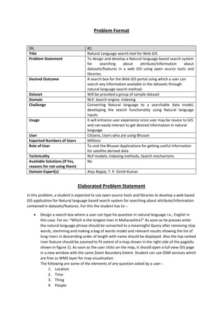
  • 1. Problem Format SN. #2. Title Natural Language search tool for Web GIS Problem Statement To design and develop a Natural language based search system for searching about attribute/information about datasets/features in a web GIS using open source tools and libraries. Desired Outcome A search box for the Web GIS portal using which a user can search any information available in the datasets through natural language search method. Dataset Will be provided a group of sample dataset Domain NLP, Search engine, Indexing Challenge Converting Natural language to a searchable data model, developing the search functionality using Natural language inputs Usage It will enhance user experience since user may be novice to GIS and can easily interact to get desired information in natural language User Citizens, Users who are using Bhuvan Expected Numbers of Users Millions Role of User To visit the Bhuvan Applications for getting useful information for satellite derived data Technicality NLP models, Indexing methods, Search mechanisms Available Solutions (if Yes, reasons for not using them) No Domain Expert(s) Anju Bajpai, T. P. Girish Kumar Elaborated Problem Statement In this problem, a student is expected to use open source tools and libraries to develop a web based GIS application for Natural language based search system for searching about attribute/information contained in datasets/features. For this the student has to :-  Design a search box where a user can type his question in natural language i.e., English in this case. For ex:-“Which is the longest river in Maharashtra?” As soon as he presses enter the natural language phrase should be converted to a meaningful Query after removing stop words, stemming and making a bag of words model and relevant results showing the list of long rivers in descending order of length with name should be displayed. Also the top ranked river feature should be zoomed to fit extent of a map shown in the right side of the page(As shown in figure 1). As soon as the user clicks on the map, it should open a full view GIS page in a new window with the same Zoom Boundary Extent. Student can use OSM services which are free as WMS layer for map visualisation. The following are some of the elements of any question asked by a user:- 1. Location 2. Time 3. Thing 4. People
  • 2. 5. Event 6. Phenomenon For Example:- 1. Which is the most populated(4) city(1)? 2. Which is the Nearest Temple(3) to my location(1)? 3. Show me the shortest route to the nearest parking to my location(1)? 4. When(2) does COVID-19(5) reach highest number of cases(4) in Maharashtra(1)?  Additionally a speech to text converter can also be used (optional feature) using tools like Web Speech API for making it directly recognizing the speech, then converting to natural language text and then further processing to search for a specific feature.  A Recommendation of similar results can also be provided to the users (desirable feature). For example, if a user is interested in Taj Mahal, you can also help them discover other important monuments of historical importance or other monuments located in Agra, or built during that period/by the same King.  Also a chart can be drawn based on the results selected in the result list(optional feature) Figure -1 Data Available:- The dataset is vector data i.e., Shapefiles of OSM data of Western India Region consisting of various maps like 1. Roads 2. Railways 3. POI 4. Buildings 5. Water
  • 3. 6. Waterways 7. Transport 8. Places of Worship 9. Natural 10. Landuse 11. Places It is further classified into following categories:- 1. Physical  1.1 Highway  1.2 Cycleway  1.3 Tracktype  1.4 Waterway  1.5 Railway  1.6 Aeroway  1.7 Aerialway  1.8 Power  1.9 Man Made  1.10 Leisure  1.11 Amenity  1.12 Shop  1.13 Tourism  1.14 Historic  1.15 Landuse  1.16 Military  1.17 Natural 2. Non Physical  2.1 Route  2.2 Boundary  2.3 Sport  2.4 Abutters  2.5 Accessories  2.6 Properties  2.7 Restrictions Data can be downloaded from the following URL:- https://download.geofabrik.de/asia/india.html More details on this can be found in the following hyperlink:- https://query2map.toolforge.org/osmhack.php?lat=23&lon=78&name=India Also, COVID-19 data with date/time and location information has been provided in CSV format. Evaluation Criteria Evaluation will be done based on the following criteria
  • 4. 1. Performance of Search Results 2. Details provided about the feature 3. Accuracy of Search 4. Accuracy of Natural Language understanding 5. Interoperability with other sources of Data 6. Additional features will have extra marks The Students should submit their complete source codes along with the installation procedure so that same can be replicated for evaluation. Also, a link has to be provided to view their installed applications. After evaluating the applications on the above criteria, a virtual meet will be held for top 10 candidates/ teams etc. through Google Meet for final assessment based on the presentation of their work. Incremental Problem 1. Integrate the census data along with district https://download.geofabrik.de/asia/india.html 2. Landuse Integration for NLP query enhancements