SlideShare a Scribd company logo
1 of 30
GOVERNMENT OF ANDHRA PRADESH
WATER RESOURCES DEPARTMENT
PROJECT : ATATURK DAM, TURKEY
G.Siva Rajendra Prasad (ID No 57)
B. Narasimha Rao (ID No 58)
ATATURK DAM, TURKEY
Introduction
Mesopotamia, as it is called the land between two rivers, has
been the cradle of many civilizations by use of the waters of the Euphrates-Tigris
Rivers and their tributaries. The Mesopotamian civilizations were dating back to
10,000 B.C. The Sumerians, Acadians, Babylonians and Assyrians are the well
known ancient civilizations of the Mesopotamia. They had constructed efficient
hydraulic systems for irrigation and flood control purposes supporting millions of
people in their times. For example the Sumerians and Babylonians carried water by
canals to their lands and cities from the Euphrates.
As a matter of fact, the need for the development systems for
the natural resources of the region aroused soon after the Second World War. In
the second half of the 20th century; modern water storages, hydraulic plants and
irrigation systems were built in countries sharing the Euphrates-Tigris Basin.
Water facilities were constructed by Turkey and Syria based on the Euphrates and
by Turkey, Iraq and Iran based on the Tigris.
CHARACTERISTICS OF THE EUPHRATES-TIGRIS BASIN
The Euphrates-Tigris basin is basically fed from snow
precipitation over the mountains of Turkey, Iraq and Iran. The Euphrates is the
longest river of western Asia. It originates from Mount Ararat at 4,500 m above
sea level nearby Lake Van. Then it goes to south by losing 2 meters per kilometer
in elevation in Turkey and crosses into Syria. After flowing southeast almost 680
km within Syria’s borders, it enters to Iraq at Al Qaim. By traveling 360 km from
the border, it reaches a giant alluvial delta at Ramali. After this point, the river
traverses the deserted regions of Iraq. Meanwhile it loses some of its water due to
both natural and manmade desert depressions and arrangements. Then, the
Euphrates becomes a tangle of channels at the downstream near Nasriyah. Some of
these channels drain into Lake of Hammar and others join the Tigris at Qurna.
The Tigris, the second largest river in western Asia, arises
near Lake Hazar at 1,150 m above sea level in eastern Turkey. Before flowing to
Iraq by constituting the Turkish-Syrian boundary for 2 km, it is being fed by
several tributaries in Turkey. Also, the river has significant contribution of several
tributaries along Iraq. Then the Euphrates and Tigris meet together forming a river
almost a kilometer wide and 190 km long which is named as Shatt-al- Arab. Due to
the contribution to the Tigris River via the lesser Zab, Diyalah and Kharun rivers,
Iran is considered to be a co-riparian of the Tigris- Euphrates system. Even tough
being a part of the drainage basin, Saudi Arabia have no contribution to or border
with the Euphrates. The Euphrates and Tigris rivers, as the main parts of a single
trans-boundary river system are linked at Shatt-al-Arab and constitute a delta.
The particular property of the hydrological flow conditions of
the Euphrates-Tigris Rivers is the irregularity between and within the years. The
extreme discharge due to snow melting especially on April and May causes severe
flooding and inundation of large areas. Unfortunately, these are not the only results
of this maximum discharge period. It also means that the loss of extra water is
needed during the drought seasons for irrigation and power generation purposes.
So the construction of retaining structures to regulate river flows and making use
of the extensive discharge for the irrigation works and hydropower generation are
necessarily needed. Therefore, by constructing large dams, it is possible to evaluate
the abundant water of the Euphrates and Tigris in wet seasons into a scarce
commodity because of heavy consumption for irrigation, hydropower generation in
summer period. In other words, the rational water and land resources development
effort should be achieved by managing the Euphrates-Tigris River systems,
properly.
Southeastern Anatolia Project (GAP)
The potential to develop the Euphrates and Tigris river basins for
hydroelectricity generation was recognized in the 1920s by Mustafa Kemal
Ataturk, the founder of the modern Turkish Republic. Modernizing Turkey
required increased supply of electricity. Following a number of surveys initiated in
1958, two detailed reconnaissance reports were presented in the mid-1960s on the
potential for irrigation and energy production in the Euphrates River basin. At the
end of the 1960s, the Government of Turkey saw the possibility of making use of
the water and land resources in the South-eastern Anatolia region on a grander
scale. Based on a contract signed in 1968 between the DSI (Directorate of State
Hydraulic works) and a joint venture of consulting firms, a study was undertaken
for the development of the water resources of the lower Euphrates basin to
generate hydroelectricity and irrigate arable lands.
In 1969, an interim report was submitted to the DSI by the joint
venture, evaluating 22 different combinations of four mainstream dams of
alternative heights and various irrigation schemes. The consultants recommended a
scheme consisting of Karakaya, Low Golkoy, and Middle Karababa dams and
power stations, the Bedir Dam on a tributary river, and two pumping plants for
irrigation diversions from the Middle Karababa reservoir. The final report,
submitted in 1970, presented the recommended scheme for the lower Euphrates
River, called the Lower Firat (Euphrates) Project. This was the only detailed plan
for the development of the South-eastern Anatolia region in existence at the time.
The Lower Firat Project was planned as a multipurpose project
for irrigation and hydropower development. The project was justified on the basis
of five national concerns.
Firstly, the project was planned as a means to meet Turkey’s
future requirements for agricultural production. Production was projected to
increase by more than 4%/year for the foreseeable future. At the time, the lower
Euphrates basin was the largest non-irrigated agricultural area in Turkey,
encompassing about 20% of all potentially irrigable land in the country. The
planned irrigation schemes were supposed to make possible a 30-fold increase in
agricultural productivity.
Secondly, the project would make the region contribute
materially to national economic growth. At the time, other economically more
developed regions in Turkey heavily subsidized the region both directly and
indirectly. Irrigation development would transform the region from an
unproductive frontier region into an important wealth-producing national asset.
Irrigation was expected to generate more indirect benefits than any other kind of
development in the region.
Thirdly, construction of mainstream dams exclusively for
irrigation purposes was expected to be difficult to justify. Therefore, the dam
projects would also “create attractive opportunities for developing low-cost
hydroelectric energy”. The hydropower plants would enable an extension of the
interconnected energy system in Turkey and thereby add to national energy
supplies. The national need for electricity was high: as much as 60% of the Turkish
population was without electricity and national per capita consumption was
approximately one-tenth of that of Western Europe. About 86% of the national
electricity demand came from the more populated and industrialized western part
of the country. Whereas in the south-western and northern Turkish provinces,
water resources were relatively restricted and partly exploited, in the eastern
provinces, they were much more abundant, especially in the Euphrates River basin.
The Lower Firat Project would involve the transmission of large amounts of power
from the eastern to the western parts of the country, mainly to Istanbul, Ankara,
and Izmir.
Fourthly, the project would enable Turkey to claim its
riparian rights to the flow of the Euphrates for beneficial uses, i.e. large-scale
irrigation. At the time, no water treaty existed among the riparian countries that
could regulate the use of the river. According to DSI, “In the absence of a water
treaty among riparian interests, precedence of beneficial use becomes an important
criterion in the adjudication of water rights”. Lastly, the project would also benefit
the region’s economy. The regional economy, almost entirely based on agriculture,
was “stagnant and deteriorating”, because population growth in the region
absorbed any small increases in agricultural productivity that was achieved.
In 1977, the decision was taken to merge the Lower Firat
Project with other plans for hydropower and agricultural development in the basins
of the Euphrates and Tigris rivers into an overall package, named Guneydogu
Anadolu Projesi or GAP. In 1980, GAP was presented as a package of 13 related
projects for hydropower generation and irrigation, seven on the Euphrates and six
on the Tigris. Underlying the formulation of GAP was the Turkish Government’s
ambition to make maximum use of the great potential for hydropower and irrigated
agriculture in the South-eastern Anatolia region recognized in the early 1970s.
Since 1975, the national electricity supply had fallen short of meeting domestic
demand, which had increased, particularly in western Turkey, as a result of rapidly
growing industries and expanding urban areas (SPO, 1988b). Moreover, the leap in
world petroleum prices during the 1970s promoted a revision of the initial energy
and pumping projects in Turkey (Kolars and Mitchell, 1991).
Turning GAP into an integrated multi-sectoral development project
In the 1980s, Turkey decided to reformulate the GAP concept into
“an integrated multi- sectoral development project”. Development of the region
would involve not only irrigated agriculture and hydropower generation but also
related sectors, including industry, infrastructure, transportation, education, health,
and social sectors. A multi-sectoral development approach would also ensure a
more rapid socio-economic development process. By simultaneously developing
the region’s infrastructure, service sectors, and general working conditions for the
construction workers, the dam projects could be implemented in a more timely and
cost-effective manner. Also, integration of the physical, economic, and socio-
cultural aspects of GAP would better justify the high cost of the physical
investments and would maximize the contribution of GAP to national
development, according to PMU/SPO. In 1987, the GAP Master Plan study was
initiated with the purpose of formulating the new objectives, strategies, and
timetables of GAP.
The Master Plan officially recognized a number of development
problems in the South-eastern Anatolia region. The region was seen to experience
low levels of education, income, and health services, and high migration rates from
rural areas to larger cities within and outside the region. The Plan also recognized a
distortion of land distribution and ownership, lack of proper planning and
management for resource utilization, unfavorable climatic and topographic
conditions, and low soil productivity. Against this background, the Master Plan has
formulated the development objectives and strategies of GAP.
Regional development objectives according to the GAP Master Plan
Firstly, GAP aims to reduce socio-economic disparities
between the region and the rest of Turkey. Improvements in regional socio-
economic conditions and social welfare fundamentally depend on the development
of agriculture and related industries. The traditional agricultural system will be
modernized through the adoption of modern irrigation technologies, mechanized
farming practices, and a diversified crop pattern oriented towards cash crops.
Agro-related industries will be established to process the agricultural products and
to supply agricultural inputs. The Master Plan also envisages an expansion of the
livestock, fishery and forestry sectors, and the development of various industries
and service sectors, such as the manufacturing industry and the engineering, trade,
banking, and finance sectors. These developments, in turn, are expected to lead to
improved employment opportunities in high-paying jobs, increased average
income levels, and the immigration of outside technical and administrative staff to
the region, thus stimulating further socio-economic development.
Secondly, GAP aims to increase the region’s contribution to the
country’s economic growth and export earnings. The region will be transformed
into an open export base from which agricultural and related products will be sent
to domestic and international markets. The success of the export industry will
depend on agricultural diversification into exportable cash crops, development of
related industries and the generation of hydropower.
Thirdly, GAP aims to increase socio-political stability in the
region, where the population is mainly of Kurdish origin. Through improved social
welfare, the Government hopes to discourage separatism and to ‘harmonize’ the
social and political identity of the region with the rest of Turkey.
Lastly, GAP aims to support urban and industrial development also
in other parts of Turkey, mainly in the west. The hydroelectricity to be produced in
the GAP region is anticipated to far exceed any foreseeable demand by local
industries, and most villages in the region were already served with electricity at
the end of 1980s.
Ataturk Dam:
The Ataturk Dam is located on the Euphrates River in Bozova,
south-east Turkey. Ataturk dam is the world's fourth largest rock fill dam which
provides hydropower and irrigation in Turkey. The dam is constructed across the
Euphrates River. The construction of dam began in 1983 and was completed in
1990. Initially it was called Karababa dam. It is named in honour of Mustafa Kenal
Ataturk, the founder of the Turkish republic.
The Euphrates receives most of its water in the form of rainfall and
melting snow, resulting in peak volumes during the months April through
May. Discharge in these two months accounts for 36 percent of the total annual
discharge of the Euphrates, while low runoff occurs in summer and autumn. The
average natural annual flow of the Euphrates has been determined from early- and
mid-twentieth century records as 20.9 cubic kilometers at Keban, 36.6 cubic
kilometers at Hīt and 21.5 cubic kilometers at Hindiya. The mean annual flow of
the Euphrates (Firat) River is estimated to be 33.6 BCM. Some 98% of the
Euphrates River runoff originates in the highlands of Turkey, while the rest of its
catchment in lower arid regions makes little contribution to the river. The main
features that distinguish the hydrologic regime of the Euphrates-Tigris River
system are their annual and seasonal fluctuations, with large floods originating
from the snow-melt in spring.
Modifications to the Karababa /Ataturk Dam project over time
In 1970, the Karababa Dam, later renamed the Ataturk Dam, was
proposed on the site of the present dam. The Karababa Dam was presented in three
alternative designs: the Low, Middle, and High Karababa Dam. These differed
significantly in design, with heights of 85, 112, and 169 m respectively. The
Middle Karababa Dam design was the most highly recommended. The Low
Karababa Dam alternative was never seriously considered, and the High Karababa
Dam would be more expensive, require high initial investments, face certain
leakage problems, be vulnerable to any major flood wave, and have an enormous
dead storage volume believed to be far greater than required.
The Middle Karababa Dam was planned as part of the Lower
Firat Project, which comprised four dams on the lower reach of the Turkish
Euphrates River. These were the Karakaya, Low Golkoy, and Middle Karababa
dams on the mainstream, and the Bedir Dam on a tributary river.
The Middle Karababa Dam was planned to serve three main
functions.
• Firstly, it would be the only dam project to provide water to the planned
irrigation area of 700,000 ha of the Lower Firat Project. On average,8600
million m^3 of irrigation water per year would be diverted from the reservoir
through two separate conveyance systems to the Urfa-Harran, Lower
Mardin, Siverek- Hilvan, Upper Mardin, and the Nusaybin-Cizre schemes.
Irrigation water would be supplied during the dry season and late summer
months in order to prolong the growing season.
• Secondly, the Middle Karababa Dam would generate electricity with an
installed power capacity of 800 MW. At full irrigation, the average annual
energy output would be 3325 GWh. Most of the electricity would be
transmitted to other parts of Turkey; only a smaller share would be supplied
locally.
• Thirdly, the dam would benefit downstream users by releasing an almost
uniform regulated flow, which would reduce the river’s high annual flow
variation and virtually eliminate the floods that occur in April and May of
most years.
• Lastly, it would create opportunities for the transportation of goods,
envelopment of fisheries, and “other corollary uses”.
Adoption of the High Karababa Dam
The formulation of GAP in 1977 necessitated a revision of the
original Lower Firat Project. By excluding the Low Golkoy Dam of 500 MW and
adding two turbines and 57 m to the Karababa Dam height, the generation capacity
of the Karababa Dam increased from 800 to 2100 MW. Moreover, the total
planned irrigation area was to be extended to 800,000 ha, by revising and
complementing the Lower Firat irrigation scheme with two new irrigation
schemes, namely the Adiyaman-Katha and Baziki-Suruc schemes. The expected
high cost of this expansion motivated the adoption of the High Karababa Dam,
which was now considered more economic than the Low Golkoy and Middle
Karababa dams together. As a result, the Middle Karababa Dam was rejected in
favour of the High Karababa Dam alternative. The proposed Low Golkoy Dam
was no longer needed, and the Bedir Dam and pumping plant were also excluded.
Instead, a new dam downstream of the High Karababa Dam was proposed, the
Birecik Dam. In total, the Euphrates River would be impounded by three
mainstream dams below the existing Keban Dam: the Karakaya, High Karababa,
and Birecik Dams. A number of smaller tributary dams were also proposed. The
High Karababa Dam was planned to irrigate the total planned 800,000 ha in the
Euphrates River basin within the region, through three separate tunnels.
Ataturk Dam and hydropower scheme
Key data
1. Hydrology
Catchment area …………………………..92,240 km^2
Annual inflow …………….………………26,585 MCM
2. Reservoir
Retention water level ……………………..EL 542.0 m
Minimum operating level….. …………….EL 526.0 m
Maximum water level………….. ………...EL 544.15 m
Active storage ……………………………..12,700 MCM
Reservoir capacity …………………………48,700 MCM
Reservoir area ……………………………..817 km^2
3. Diversion structures
Number of tunnels, concrete-lined…………. 3 No’s
Length ……………………………………….4, 100 m
Diameter ……………………………………. 8.0 m
Discharge capacity………………………….. 3,900 m3
/s
4. Dam
Type ……………………………………..Rock-fill with central core
Height above lowest foundation ………..169 m
Crest length…………………………….. 1,664 m
Elevation of top of dam …………………EL 549.0 m
Volume of dam ………………………….84.5 MCM
5. Spillway
Type …………………………………….. Controlled overflow spillway
Type of gates ………………………………6 radial gates
Size of gates ……………………………….16 m × 18 m
Discharge capacity …………………………16,800 m3
/s
6. Power intake
Type ……………………………………Concrete gravity dam, 8 blocks
Type of gates …………………………..8 roller gates
Size of gates ……………………………7.5 m × 7.5 m
7. Penstocks
Number of penstocks …………………8
Length……………………………… Between 515 and 640 m
Diameter ………………………………7.25 m
8. Powerhouse
Location …………………………..Adjacent to the dam toe
Size (l × w × h) ……………………257 m × 53 m × 49 m
Net head ……………………………151 m
Valves …………………………….8 Butterfly
Turbines…………………………. 8 Francis
Rated space …………………….....150 rpm
Turbine discharge …………………1,748 m 3 /s
Installed capacity………………….. 8 × 300 = 2,400 MW
Annual energy total ……………….8,900 GWh
Settlement of dam
The construction of the dam was started with the
construction of the upstream coffer dam beginning of September 1985. The
construction of the main body of the dam itself was started by December 1986, and
completed in only 3 years and 8 months, which is much less than the originally
estimated 5–5.5 years, by August. The fill of the dam contains high plasticity clay
for the impervious zone, natural and processed alluvium for the filter zones, basalt
and placated lime-stone for the shell zones.
As the reservoir level started to rise, settlement problems
started to occur along the crest reaching considerable levels by May 1992 and the
weathered vesicular basalt used in the rock-fill section of the dam started to slake
seriously. The elevation of the crest has fallen down to such an extent that now the
upper part of the dam is being reconstructed to the original height of 549 m in
order to maintain the 7 m freeboard and keep the dam operational. The settlement
and slaking problems of the dam were investigated both in the field and the
laboratory using soil and rock mechanical techniques. Standard proctor tests were
run to determine the optimum moisture content at which the highest dry density
(best compaction) is obtained during compaction of the impervious clay core.
Consolidation tests were performed on undisturbed compacted clay core samples
to determine if the field compaction of the clay core was done to the standards
determined in the laboratory. Unconfined compression tests were run on the two
different (sound aphanitic and weathered vesicular) basalts used in the rock-fill
section of the dam to determine their unconfined compressive strengths. Slake
durability tests were run on the same basalts to determine their durability under
wetting and drying cycles. Petro graphic and X-ray analysis were done so as to
study the mineralogical contents of the two basalts and in turn, to determine the
cause of rapid slaking of the vesicular textured weathered basalt. The consolidation
test results show that, the field compaction of the impervious clay core of the dam
was not done to the standards determined through the proctor tests in the
laboratory. The unconfined compressive strength of the sound aphanitic basalt is
more than ten times greater than the weathered vesicular basalt, and while the
former has extremely high durability the latter only has medium durability.
Because of nontronite (iron montmorillonite) and secondary calcite amygdules
filling the vesicles, the weathered vesicular basalt used in the rock-fill section is
slaking badly causing additional settlement and landslides both in the clay core
which is already settling and the rock-fill section of the dam. With the continuing
slaking, the present reconstruction of the crest up to the theoretically intended
height of 549 m to maintain the 7 m freeboard and keep the dam operational seems
only to be a temporary solution.
Employment during construction
Employment opportunities in the GAP region have been
historically limited because of limited economic development. With the beginning
of the construction of the Ataturk Dam and the associated hydraulic infrastructure,
the area became a magnet for people seeking employment, from both within and
outside the region. The private sector companies that carried out all the
construction suddenly opened a new vista for employment for skilled and non-
skilled personnel.
The contractor for the construction of the Ataturk Dam
and HP was ATA Insaat Sanayi ve Ticaret AS. The construction of the dam started
in November 1983 with only 89 workers. The total number of workers employed
during construction of the dam was 16 431, of whom 466 were technical staff, and
the rest skilled and unskilled workers (nearly 1000 of them sub-contracted).
Between November 1983 and May 1996, there was an average of 3100
persons/month of work.
The technical and skilled staff came to the region from other
parts of Turkey, as local people had neither the knowledge nor the skill to construct
such a large and complex structure. Most of the skilled workers who migrated to
the dam site had gained their knowledge and experience during the construction of
other similar structures such as the Keban, Karakaya and Altintas Dams. Local
people represented 95% of all the workers employed, but all of them were initially
recruited as unskilled employees. The Directorate of Machinery trained many
unskilled personnel, who later worked as drivers, machinery operators (light,
medium and heavy), carpenters, turners, metal workers, etc.
The number of people working on construction of the dam
increased steadily with time. As noted earlier, the number of employees in
November 1983, when the construction started, was 89 but a year later, by October
1984, the number had increased to more than 1000 workers. At the peak of
construction, which was reached in October 1988, the number of workers was
7688. The number started to decline steadily thereafter, and had decreased by half
in about two years. By May 1996, the number had reduced to only 281 workers.
The estimated number of people hired during the construction of the
Ataturk Dam was 16,400. If this number is multiplied by a factor of 7 (average
number of persons per family in south-east Turkey), some 114 800 people living in
the region were sustained by the income generated by the employment created
during construction of the Ataturk Dam.
LAND ACQUISITION AND RESETTLEMENT
The Ataturk Dam as being the largest sub-structure of the GAP
have been affected a large area and many people. Its reservoir affects 143 villages.
Approximately 45,000 people have been influenced by the project in some way
according to the registration, population documents and etc. Some of those people
may have been the ones that migrated to the big cities due to the negative
economical conditions and still had some registered land in the project region.
Ataturk Dam Expropriation which is the largest expropriation project of Turkey
governs 81,700 hectares of land. The expropriation process of Ataturk Dam was
carried by General Directorate of State Hydraulics between 1983 and 1996. Totally
the expropriation compensation of 25,700 parcel (43,400 ha) which approximately
equals a value of 494 Trillion TL (in 2004 unit prices) have been paid to the
owners. Also people, who thought that the compensation payment is
underestimated, have sued General Directorate of State Hydraulics to increase the
compensation payment. These payments that belong to the ended suits are
approximately 163 Trillion TL (in 2004 unit prices).
. The Directorate of Rural Affairs has estimated that 1129 families
had to be displaced because of the Ataturk Dam project during the period 1988 to
1997.Out of this number, 44% were to be resettled in rural areas, and the balance
of 56% in urban areas. 100% of the population had been fully compensated, but
only 30% of the population had been resettled (344 families), and 70% still had to
be resettled (369 families in rural areas, and 416 families in urban areas). It is
estimated that an average family consists of 10 persons. However, the records of
DSI do not include the total number of families that have to be resettled. The
records note only that the number of families that were involuntarily resettled from
1988 to July 2000 was 344 (133 in rural areas, and 211 in urban areas), and that the
number of families waiting to be resettled is rural areas was 333. The families to be
resettled in urban areas were not included.
New Economic Activities
It was natural that several new economic activities were generated
during the construction and operation of the Ataturk Dam and the associated
hydraulic infrastructures. Among these activities were fishing and fishing-related
industry (boat-building, fishing-net construction and repair, fish processing and
marketing,etc.), agricultural production through pumped irrigation directly from
the reservoir, transportation through ferry boats in the reservoir, tourism (new
hotels and restaurants); developments in the agro-industrial and industrial sectors,
etc.
Fishing and Fishing-related Industries
The south-east region of Turkey is arid. Accordingly, most
of the agriculture practiced is still rain-fed, and fishing and fishing-related
activities were basically unknown to most people before the construction of the
dam and the reservoir. The GAP Administration and DSI are aware of the
economic, social and environmental impacts, both positive and negative, that may
directly occur as a result of the construction of water projects in general. One of
the important tasks of DSI as a planning and implementing agency is to advise
local populations as to how best to take advantage of the newly available water
resources for their own benefit as well as for the benefit of the communities
concerned. These include income-generating activities, use of new varieties of
food that were not locally available earlier, improvements in water supply and
sanitation facilities, crop diversification and increase in agricultural yields,
promotion of fishery, etc. DSI is also the institution that is responsible for carrying
out activities related to water conservation and maximizing the economic benefits
from the water projects. The assessment of the impacts of the reservoir included its
characterization; limn logical studies, fish production, recreational activities, etc. In
the case of the Ataturk Dam, the Department of Operations and Maintenance,
Water Products Branch of DSI, prepared an Assessment of Water Products and
Fishing Ground in the Ataturk Dam Lake (DSI, 1995). Among the main objectives
were definition of the characteristics of the lake, study of the flora as well as any
structure that would be covered by the water in the reservoir, conduct of the
necessary limn logical studies, estimation of fish production in the reservoir,
including stock assessment and feeding requirements, establishment of a Water
Products Station, and provision of necessary support to establish a cooperative for
Fishermen. The fieldwork on which the assessment was based was carried out
between May 1992 and March 1993. Laboratory work was conducted between
July and November 1993, and the report was completed in 1994. Limn logical
studies in the dam concluded that there was no fish of economic importance in the
reservoir. The stock of existing species was very low and there were considerable
problems in terms of hatching. Accordingly, it was decided to introduce large fish
populations (especially carp) in the reservoir, using 5–6 cm fingerlings from the
Elazig-Keban Water Products Centre. In 1991, 200 000 carp fingerlings were
released into the lake. The number of fingerlings released increased subsequently
to 6,00,000 in 1992, and then to 20,00,000 each year in 1993 and 1994. On the
basis of data currently available, it appears that the density of fish in the Ataturk
Reservoir is less than has been observed in the Karakaya and Keban reservoirs.
This is to be expected and is primarily due to the fact that the Ataturk reservoir is
new and thus the amount of nutrients available for .sh production is low. On the
basis of investigations carried out by DSI, the fish stock in the Ataturk Reservoir
was about 850 tons/year when the assessment referred to earlier was carried out.
This stock comprised mainly varieties such as biyikli, bizir, in, sis, cultured carp,
fresh water scud, and bass. According to the DSI reports, there are many bays in
Adiyaman at present in the Ataturk Reservoir. The report noted that it should be
possible to establish successfully cage fishing in these bays. In fact, cage fishing is
considered to be an important potential economic activity for people living near the
reservoir. However, this may have some water-quality implications which need to
be considered carefully.
Irrigated Agriculture
Before the irrigation started, the main crops of the region were
wheat and barley. In 1995, about 30 000 ha were irrigated with cotton as the main
crop. By 1997, Evaluation of Impacts of the Ataturk Dam 459 approximately
60,000 ha were cultivated with a gross agricultural output value (GAOV) of $125
million/year. The increase in cotton production has already spurred development in
cotton-related agro-industries, such as cotton ginning, manufacture of cotton-seed
oil, cloth mills, etc. Economic and social activities have further increased in
Sanliurfa. An improvement in the lifestyle of the farmer’s benefited by irrigation in
the plain is already visible. Development in Sanliurfa can be de.ned before
irrigation and after irrigation.
Industrial Activities
As a direct result of developments stemming from the
construction of the Ataturk Dam, industrial and commercial activities are
accelerating rapidly in the region. The urban centers in the region have witnessed
explosive growth in immigration because of enhanced employment potential,
including self-employment. Construction activities have increased substantially, as
have commercial activities for both formal and informal sectors. Transportation
and communication links within the region, as well as between the region and the
rest of Turkey, have opened up new potential for economic and industrial activities
that simply did not exist earlier. Because of increasing demand, frequency of
commercial flights between the urban centers of the GAP region and the rest of
Turkey has expanded exponentially in recent years. Such increased and improved
transportation and communication linkages are likely to enhance the
socioeconomic development of the region at a rapid rate in the coming years. A
good example of industrial and commercial development is Sanliurfa. The city has
already established an industrial zone which is now almost full, as a result of which
a second zone of about 11,000 decors is now being developed. A free zone for
exports and imports would be developed in this second zone. The first zone is
mainly occupied by agro-industrial activities that are cotton-related, e.g. cotton
ginning, textiles, cotton-seed oil, etc. Prior to the construction of the Ataturk Dam,
such activities were extremely limited. These agro-industries are not only
generating employment that is improving the living conditions of many people but
also are providing major value-added service products which were not available
earlier. In the process, they are buying the raw materials from the farmers, which
further boost the economy of the region. A secondary benefit of the new agro-
industrial development is that the workers employed need housing, markets and
other services which are boosting further the employment conditions of the region.
The Ataturk Dam has thus directly contributed to a ‘win–win’ situation, whose
socioeconomic benefits now encompass not only the GAP region but also the rest
of the country through a variety of direct and indirect pathways.
The GAP region is now at an early phase of industrial
development. The levels of education and training that are now prevalent in the
region are still significantly below the national average, though in recent years the
gaps between the two have been closing. While at present a very significant
number of unskilled laborers can be absorbed in the labour force, the region will
increasingly need more and more skilled labour, if the sustainability of
employment generation conditions is to be ensured. On the basis of the available
evidence, it is clear that many of the unskilled labourers are progressive learning
new skills, which increases their salaries and employment opportunities. Both of
these are of course strong incentives to learn new skills. In spite of these advances,
however, it is now clear that the region is already suffering from a shortage of
skilled workers. As new industries are established and existing ones are
modernized, demand for skilled labour will accelerate. This demand can be met by
increasing the training facilities available in the region and by migration of skilled
workers from other parts of Turkey to the region. This is likely to put inflationary
pressure on wages for skilled labour, which could reduce one of the important
economic advantages Turkey has at present. Equally, dependence on skilled
workers from outside the region will assure that the workers in the region will be
increasingly restricted to low-paid and undesirable jobs. This could create social
tension between the low-paid local workers and highly paid employees coming
from outside the region. Thus, viewed from any direction, the best solution would
be to take appropriate and timely steps to increase the education and skills of the
local workers. While increasing industrialization has ensured many benefits for the
people of the region, it also is bringing in its wake certain social and environmental
costs. The main concern at present is the negative environmental and social
impacts of wastewater management practices. Proper wastewater treatment by any
industry is now a rare exception rather than the norm. The situation is serious for
the industrial zone in Sanliurfa because of the high concentration of industrial
activities in the area. Even though the Sanliurfa industrial estate is 15 km away
from the city, the continuation of indiscriminate discharge of wastewater could
have major social and health costs in the coming years for a variety of reasons.
First, even though Sanliurfa is at a reasonable distance from the industrial estate,
groundwater in the area may become contaminated with industrial waste products
over the years. Depending on the gradient of the flow, the region’s groundwater
may become contaminated by industrial waste products, not just in Sanliurfa but in
the various cities where industrial development is being encouraged. Second, the
industrial estate may be 15 km away from Sanliurfa, but it is located near some
villages and a nearby stream, which serves as a source of water for some people.
The people and the ecosystems of the nearby villages are likely to bear the first
adverse health and environmental impacts of the existing wastewater discharges.
In the near term, monitoring of the quality of wastewater discharges and
groundwater near the estate is necessary. Over the short to medium term, it is
necessary to prepare and then implement a plan for wastewater treatment for the
industrial zone. There was not time to analyze the wastewater situation in any
depth. However, even if there had been, this would not still have been possible
because of the absence of data on the quantity and quality of wastewater generated.
However, prima facie, there appears to be a good case to construct a communal
wastewater plant for the industrial estate. Some discussions have already taken
place with the World Bank and the Islamic Development Bank for a possible loan
to construct a wastewater treatment plant. A strategy for wastewater management
for the industrial estate of Sanliurfa should now receive priority attention. This is
because a second zone is in the process of establishment, which is likely to
increase the magnitude of the overall problem. The experience with the Sanliurfa
industrial zone project indicates that any new similar project in the region must
consider a wastewater and solid waste management plan from the very beginning
of the planning process.
References
• http://www.greenstrategy.se/wp-content/uploads/2013/05/Brismar-
NRF.pdf
• Impact of the Ataturk Dam Lake on Agro-Meteorological Aspects of The
South-eastern Anatolia Region Using Remote Sensing and GIS Analysis
• https://www.britannica.com/topic/Ataturk-Dam
• https://pdfs.semanticscholar.org/2050/e31f75c776feef498a3c66b790b95347
5cef.pdf

More Related Content

Similar to Ataturk dam report

Inter linking of river in india...
Inter linking of river in india...Inter linking of river in india...
Inter linking of river in india...Puspendu Samanta
 
Inter linking of river in india
Inter linking of river in indiaInter linking of river in india
Inter linking of river in indiaPuspendu Samanta
 
Suitability of egyptian deserts for sustainable urban development
Suitability of egyptian deserts for sustainable urban developmentSuitability of egyptian deserts for sustainable urban development
Suitability of egyptian deserts for sustainable urban developmentAlexander Decker
 
Water Resources of Pakistan
Water Resources of Pakistan Water Resources of Pakistan
Water Resources of Pakistan h9Abdurrahman
 
River Interlinking Projects for Socio Economic Transformation
River Interlinking Projects for Socio Economic TransformationRiver Interlinking Projects for Socio Economic Transformation
River Interlinking Projects for Socio Economic TransformationShailesh Herale
 
Mullaperiyar dam voice of 3.5 million
Mullaperiyar dam voice of 3.5 millionMullaperiyar dam voice of 3.5 million
Mullaperiyar dam voice of 3.5 millionVimal Kumar
 
S5c7 chapter 7-facts and figures related to floods in india.
S5c7 chapter 7-facts and figures related to floods in india.S5c7 chapter 7-facts and figures related to floods in india.
S5c7 chapter 7-facts and figures related to floods in india.Shivu P
 
Hydro potential in pakistan wapda 2008
Hydro potential in pakistan   wapda 2008Hydro potential in pakistan   wapda 2008
Hydro potential in pakistan wapda 2008zubeditufail
 
Hydro potential in pakistan wapda 2008
Hydro potential in pakistan   wapda 2008Hydro potential in pakistan   wapda 2008
Hydro potential in pakistan wapda 2008zubeditufail
 
Analyzing the Effectiveness of Modern Irrigation Methods in Iraq
Analyzing the Effectiveness of Modern Irrigation Methods in IraqAnalyzing the Effectiveness of Modern Irrigation Methods in Iraq
Analyzing the Effectiveness of Modern Irrigation Methods in IraqDr. Amarjeet Singh
 
Analyzing the Effectiveness of Modern Irrigation Methods in Iraq
Analyzing the Effectiveness of Modern Irrigation Methods in IraqAnalyzing the Effectiveness of Modern Irrigation Methods in Iraq
Analyzing the Effectiveness of Modern Irrigation Methods in IraqDr. Amarjeet Singh
 
The impact of ilisu dam on duhok water intake on tigris river
The impact of ilisu dam on duhok water intake on tigris riverThe impact of ilisu dam on duhok water intake on tigris river
The impact of ilisu dam on duhok water intake on tigris riverMehdi Fasihi Harandi
 
development of water resources in INDIA and neighboring countries
development of water resources in INDIA and neighboring countriesdevelopment of water resources in INDIA and neighboring countries
development of water resources in INDIA and neighboring countriesJisha John
 
Interlinking of rivers in India
Interlinking of rivers in IndiaInterlinking of rivers in India
Interlinking of rivers in IndiaAditya Kumar
 
NATO Book - Peace Canal on the Golan Heights
NATO Book - Peace Canal on the Golan HeightsNATO Book - Peace Canal on the Golan Heights
NATO Book - Peace Canal on the Golan Heightsboazwachtel
 
Hydroelectric energy
Hydroelectric energy Hydroelectric energy
Hydroelectric energy ameermudasar
 

Similar to Ataturk dam report (20)

Inter linking of river in india...
Inter linking of river in india...Inter linking of river in india...
Inter linking of river in india...
 
Inter linking of river in india
Inter linking of river in indiaInter linking of river in india
Inter linking of river in india
 
Suitability of egyptian deserts for sustainable urban development
Suitability of egyptian deserts for sustainable urban developmentSuitability of egyptian deserts for sustainable urban development
Suitability of egyptian deserts for sustainable urban development
 
Interlinking of rivers (NRLP)
Interlinking of rivers (NRLP)Interlinking of rivers (NRLP)
Interlinking of rivers (NRLP)
 
SE4ALL Doc Fin
SE4ALL Doc FinSE4ALL Doc Fin
SE4ALL Doc Fin
 
Water Resources of Pakistan
Water Resources of Pakistan Water Resources of Pakistan
Water Resources of Pakistan
 
INTERLINKING OF RIVERS
INTERLINKING OF             RIVERSINTERLINKING OF             RIVERS
INTERLINKING OF RIVERS
 
River Interlinking Projects for Socio Economic Transformation
River Interlinking Projects for Socio Economic TransformationRiver Interlinking Projects for Socio Economic Transformation
River Interlinking Projects for Socio Economic Transformation
 
Mullaperiyar dam voice of 3.5 million
Mullaperiyar dam voice of 3.5 millionMullaperiyar dam voice of 3.5 million
Mullaperiyar dam voice of 3.5 million
 
S5c7 chapter 7-facts and figures related to floods in india.
S5c7 chapter 7-facts and figures related to floods in india.S5c7 chapter 7-facts and figures related to floods in india.
S5c7 chapter 7-facts and figures related to floods in india.
 
Hydro potential in pakistan wapda 2008
Hydro potential in pakistan   wapda 2008Hydro potential in pakistan   wapda 2008
Hydro potential in pakistan wapda 2008
 
Hydro potential in pakistan wapda 2008
Hydro potential in pakistan   wapda 2008Hydro potential in pakistan   wapda 2008
Hydro potential in pakistan wapda 2008
 
Analyzing the Effectiveness of Modern Irrigation Methods in Iraq
Analyzing the Effectiveness of Modern Irrigation Methods in IraqAnalyzing the Effectiveness of Modern Irrigation Methods in Iraq
Analyzing the Effectiveness of Modern Irrigation Methods in Iraq
 
Analyzing the Effectiveness of Modern Irrigation Methods in Iraq
Analyzing the Effectiveness of Modern Irrigation Methods in IraqAnalyzing the Effectiveness of Modern Irrigation Methods in Iraq
Analyzing the Effectiveness of Modern Irrigation Methods in Iraq
 
The impact of ilisu dam on duhok water intake on tigris river
The impact of ilisu dam on duhok water intake on tigris riverThe impact of ilisu dam on duhok water intake on tigris river
The impact of ilisu dam on duhok water intake on tigris river
 
development of water resources in INDIA and neighboring countries
development of water resources in INDIA and neighboring countriesdevelopment of water resources in INDIA and neighboring countries
development of water resources in INDIA and neighboring countries
 
Turkey gap scheme
Turkey gap schemeTurkey gap scheme
Turkey gap scheme
 
Interlinking of rivers in India
Interlinking of rivers in IndiaInterlinking of rivers in India
Interlinking of rivers in India
 
NATO Book - Peace Canal on the Golan Heights
NATO Book - Peace Canal on the Golan HeightsNATO Book - Peace Canal on the Golan Heights
NATO Book - Peace Canal on the Golan Heights
 
Hydroelectric energy
Hydroelectric energy Hydroelectric energy
Hydroelectric energy
 

Recently uploaded

UNIT - IV - Air Compressors and its Performance
UNIT - IV - Air Compressors and its PerformanceUNIT - IV - Air Compressors and its Performance
UNIT - IV - Air Compressors and its Performancesivaprakash250
 
AKTU Computer Networks notes --- Unit 3.pdf
AKTU Computer Networks notes ---  Unit 3.pdfAKTU Computer Networks notes ---  Unit 3.pdf
AKTU Computer Networks notes --- Unit 3.pdfankushspencer015
 
VIP Call Girls Service Hitech City Hyderabad Call +91-8250192130
VIP Call Girls Service Hitech City Hyderabad Call +91-8250192130VIP Call Girls Service Hitech City Hyderabad Call +91-8250192130
VIP Call Girls Service Hitech City Hyderabad Call +91-8250192130Suhani Kapoor
 
Introduction to Multiple Access Protocol.pptx
Introduction to Multiple Access Protocol.pptxIntroduction to Multiple Access Protocol.pptx
Introduction to Multiple Access Protocol.pptxupamatechverse
 
UNIT-II FMM-Flow Through Circular Conduits
UNIT-II FMM-Flow Through Circular ConduitsUNIT-II FMM-Flow Through Circular Conduits
UNIT-II FMM-Flow Through Circular Conduitsrknatarajan
 
Porous Ceramics seminar and technical writing
Porous Ceramics seminar and technical writingPorous Ceramics seminar and technical writing
Porous Ceramics seminar and technical writingrakeshbaidya232001
 
Java Programming :Event Handling(Types of Events)
Java Programming :Event Handling(Types of Events)Java Programming :Event Handling(Types of Events)
Java Programming :Event Handling(Types of Events)simmis5
 
Introduction to IEEE STANDARDS and its different types.pptx
Introduction to IEEE STANDARDS and its different types.pptxIntroduction to IEEE STANDARDS and its different types.pptx
Introduction to IEEE STANDARDS and its different types.pptxupamatechverse
 
Call Girls Service Nagpur Tanvi Call 7001035870 Meet With Nagpur Escorts
Call Girls Service Nagpur Tanvi Call 7001035870 Meet With Nagpur EscortsCall Girls Service Nagpur Tanvi Call 7001035870 Meet With Nagpur Escorts
Call Girls Service Nagpur Tanvi Call 7001035870 Meet With Nagpur EscortsCall Girls in Nagpur High Profile
 
(SHREYA) Chakan Call Girls Just Call 7001035870 [ Cash on Delivery ] Pune Esc...
(SHREYA) Chakan Call Girls Just Call 7001035870 [ Cash on Delivery ] Pune Esc...(SHREYA) Chakan Call Girls Just Call 7001035870 [ Cash on Delivery ] Pune Esc...
(SHREYA) Chakan Call Girls Just Call 7001035870 [ Cash on Delivery ] Pune Esc...ranjana rawat
 
Extrusion Processes and Their Limitations
Extrusion Processes and Their LimitationsExtrusion Processes and Their Limitations
Extrusion Processes and Their Limitations120cr0395
 
VIP Call Girls Service Kondapur Hyderabad Call +91-8250192130
VIP Call Girls Service Kondapur Hyderabad Call +91-8250192130VIP Call Girls Service Kondapur Hyderabad Call +91-8250192130
VIP Call Girls Service Kondapur Hyderabad Call +91-8250192130Suhani Kapoor
 
The Most Attractive Pune Call Girls Manchar 8250192130 Will You Miss This Cha...
The Most Attractive Pune Call Girls Manchar 8250192130 Will You Miss This Cha...The Most Attractive Pune Call Girls Manchar 8250192130 Will You Miss This Cha...
The Most Attractive Pune Call Girls Manchar 8250192130 Will You Miss This Cha...ranjana rawat
 
MANUFACTURING PROCESS-II UNIT-5 NC MACHINE TOOLS
MANUFACTURING PROCESS-II UNIT-5 NC MACHINE TOOLSMANUFACTURING PROCESS-II UNIT-5 NC MACHINE TOOLS
MANUFACTURING PROCESS-II UNIT-5 NC MACHINE TOOLSSIVASHANKAR N
 
Sheet Pile Wall Design and Construction: A Practical Guide for Civil Engineer...
Sheet Pile Wall Design and Construction: A Practical Guide for Civil Engineer...Sheet Pile Wall Design and Construction: A Practical Guide for Civil Engineer...
Sheet Pile Wall Design and Construction: A Practical Guide for Civil Engineer...Dr.Costas Sachpazis
 
APPLICATIONS-AC/DC DRIVES-OPERATING CHARACTERISTICS
APPLICATIONS-AC/DC DRIVES-OPERATING CHARACTERISTICSAPPLICATIONS-AC/DC DRIVES-OPERATING CHARACTERISTICS
APPLICATIONS-AC/DC DRIVES-OPERATING CHARACTERISTICSKurinjimalarL3
 
Introduction and different types of Ethernet.pptx
Introduction and different types of Ethernet.pptxIntroduction and different types of Ethernet.pptx
Introduction and different types of Ethernet.pptxupamatechverse
 
Top Rated Pune Call Girls Budhwar Peth ⟟ 6297143586 ⟟ Call Me For Genuine Se...
Top Rated  Pune Call Girls Budhwar Peth ⟟ 6297143586 ⟟ Call Me For Genuine Se...Top Rated  Pune Call Girls Budhwar Peth ⟟ 6297143586 ⟟ Call Me For Genuine Se...
Top Rated Pune Call Girls Budhwar Peth ⟟ 6297143586 ⟟ Call Me For Genuine Se...Call Girls in Nagpur High Profile
 
SPICE PARK APR2024 ( 6,793 SPICE Models )
SPICE PARK APR2024 ( 6,793 SPICE Models )SPICE PARK APR2024 ( 6,793 SPICE Models )
SPICE PARK APR2024 ( 6,793 SPICE Models )Tsuyoshi Horigome
 

Recently uploaded (20)

UNIT - IV - Air Compressors and its Performance
UNIT - IV - Air Compressors and its PerformanceUNIT - IV - Air Compressors and its Performance
UNIT - IV - Air Compressors and its Performance
 
AKTU Computer Networks notes --- Unit 3.pdf
AKTU Computer Networks notes ---  Unit 3.pdfAKTU Computer Networks notes ---  Unit 3.pdf
AKTU Computer Networks notes --- Unit 3.pdf
 
VIP Call Girls Service Hitech City Hyderabad Call +91-8250192130
VIP Call Girls Service Hitech City Hyderabad Call +91-8250192130VIP Call Girls Service Hitech City Hyderabad Call +91-8250192130
VIP Call Girls Service Hitech City Hyderabad Call +91-8250192130
 
Introduction to Multiple Access Protocol.pptx
Introduction to Multiple Access Protocol.pptxIntroduction to Multiple Access Protocol.pptx
Introduction to Multiple Access Protocol.pptx
 
UNIT-II FMM-Flow Through Circular Conduits
UNIT-II FMM-Flow Through Circular ConduitsUNIT-II FMM-Flow Through Circular Conduits
UNIT-II FMM-Flow Through Circular Conduits
 
Porous Ceramics seminar and technical writing
Porous Ceramics seminar and technical writingPorous Ceramics seminar and technical writing
Porous Ceramics seminar and technical writing
 
Java Programming :Event Handling(Types of Events)
Java Programming :Event Handling(Types of Events)Java Programming :Event Handling(Types of Events)
Java Programming :Event Handling(Types of Events)
 
Introduction to IEEE STANDARDS and its different types.pptx
Introduction to IEEE STANDARDS and its different types.pptxIntroduction to IEEE STANDARDS and its different types.pptx
Introduction to IEEE STANDARDS and its different types.pptx
 
Call Girls Service Nagpur Tanvi Call 7001035870 Meet With Nagpur Escorts
Call Girls Service Nagpur Tanvi Call 7001035870 Meet With Nagpur EscortsCall Girls Service Nagpur Tanvi Call 7001035870 Meet With Nagpur Escorts
Call Girls Service Nagpur Tanvi Call 7001035870 Meet With Nagpur Escorts
 
(SHREYA) Chakan Call Girls Just Call 7001035870 [ Cash on Delivery ] Pune Esc...
(SHREYA) Chakan Call Girls Just Call 7001035870 [ Cash on Delivery ] Pune Esc...(SHREYA) Chakan Call Girls Just Call 7001035870 [ Cash on Delivery ] Pune Esc...
(SHREYA) Chakan Call Girls Just Call 7001035870 [ Cash on Delivery ] Pune Esc...
 
Extrusion Processes and Their Limitations
Extrusion Processes and Their LimitationsExtrusion Processes and Their Limitations
Extrusion Processes and Their Limitations
 
VIP Call Girls Service Kondapur Hyderabad Call +91-8250192130
VIP Call Girls Service Kondapur Hyderabad Call +91-8250192130VIP Call Girls Service Kondapur Hyderabad Call +91-8250192130
VIP Call Girls Service Kondapur Hyderabad Call +91-8250192130
 
The Most Attractive Pune Call Girls Manchar 8250192130 Will You Miss This Cha...
The Most Attractive Pune Call Girls Manchar 8250192130 Will You Miss This Cha...The Most Attractive Pune Call Girls Manchar 8250192130 Will You Miss This Cha...
The Most Attractive Pune Call Girls Manchar 8250192130 Will You Miss This Cha...
 
MANUFACTURING PROCESS-II UNIT-5 NC MACHINE TOOLS
MANUFACTURING PROCESS-II UNIT-5 NC MACHINE TOOLSMANUFACTURING PROCESS-II UNIT-5 NC MACHINE TOOLS
MANUFACTURING PROCESS-II UNIT-5 NC MACHINE TOOLS
 
Sheet Pile Wall Design and Construction: A Practical Guide for Civil Engineer...
Sheet Pile Wall Design and Construction: A Practical Guide for Civil Engineer...Sheet Pile Wall Design and Construction: A Practical Guide for Civil Engineer...
Sheet Pile Wall Design and Construction: A Practical Guide for Civil Engineer...
 
APPLICATIONS-AC/DC DRIVES-OPERATING CHARACTERISTICS
APPLICATIONS-AC/DC DRIVES-OPERATING CHARACTERISTICSAPPLICATIONS-AC/DC DRIVES-OPERATING CHARACTERISTICS
APPLICATIONS-AC/DC DRIVES-OPERATING CHARACTERISTICS
 
Introduction and different types of Ethernet.pptx
Introduction and different types of Ethernet.pptxIntroduction and different types of Ethernet.pptx
Introduction and different types of Ethernet.pptx
 
Top Rated Pune Call Girls Budhwar Peth ⟟ 6297143586 ⟟ Call Me For Genuine Se...
Top Rated  Pune Call Girls Budhwar Peth ⟟ 6297143586 ⟟ Call Me For Genuine Se...Top Rated  Pune Call Girls Budhwar Peth ⟟ 6297143586 ⟟ Call Me For Genuine Se...
Top Rated Pune Call Girls Budhwar Peth ⟟ 6297143586 ⟟ Call Me For Genuine Se...
 
SPICE PARK APR2024 ( 6,793 SPICE Models )
SPICE PARK APR2024 ( 6,793 SPICE Models )SPICE PARK APR2024 ( 6,793 SPICE Models )
SPICE PARK APR2024 ( 6,793 SPICE Models )
 
Roadmap to Membership of RICS - Pathways and Routes
Roadmap to Membership of RICS - Pathways and RoutesRoadmap to Membership of RICS - Pathways and Routes
Roadmap to Membership of RICS - Pathways and Routes
 

Ataturk dam report

  • 1. GOVERNMENT OF ANDHRA PRADESH WATER RESOURCES DEPARTMENT PROJECT : ATATURK DAM, TURKEY G.Siva Rajendra Prasad (ID No 57) B. Narasimha Rao (ID No 58)
  • 2. ATATURK DAM, TURKEY Introduction Mesopotamia, as it is called the land between two rivers, has been the cradle of many civilizations by use of the waters of the Euphrates-Tigris Rivers and their tributaries. The Mesopotamian civilizations were dating back to 10,000 B.C. The Sumerians, Acadians, Babylonians and Assyrians are the well known ancient civilizations of the Mesopotamia. They had constructed efficient hydraulic systems for irrigation and flood control purposes supporting millions of people in their times. For example the Sumerians and Babylonians carried water by canals to their lands and cities from the Euphrates. As a matter of fact, the need for the development systems for the natural resources of the region aroused soon after the Second World War. In the second half of the 20th century; modern water storages, hydraulic plants and irrigation systems were built in countries sharing the Euphrates-Tigris Basin. Water facilities were constructed by Turkey and Syria based on the Euphrates and by Turkey, Iraq and Iran based on the Tigris. CHARACTERISTICS OF THE EUPHRATES-TIGRIS BASIN The Euphrates-Tigris basin is basically fed from snow precipitation over the mountains of Turkey, Iraq and Iran. The Euphrates is the longest river of western Asia. It originates from Mount Ararat at 4,500 m above sea level nearby Lake Van. Then it goes to south by losing 2 meters per kilometer in elevation in Turkey and crosses into Syria. After flowing southeast almost 680
  • 3. km within Syria’s borders, it enters to Iraq at Al Qaim. By traveling 360 km from the border, it reaches a giant alluvial delta at Ramali. After this point, the river traverses the deserted regions of Iraq. Meanwhile it loses some of its water due to both natural and manmade desert depressions and arrangements. Then, the Euphrates becomes a tangle of channels at the downstream near Nasriyah. Some of these channels drain into Lake of Hammar and others join the Tigris at Qurna. The Tigris, the second largest river in western Asia, arises near Lake Hazar at 1,150 m above sea level in eastern Turkey. Before flowing to Iraq by constituting the Turkish-Syrian boundary for 2 km, it is being fed by several tributaries in Turkey. Also, the river has significant contribution of several tributaries along Iraq. Then the Euphrates and Tigris meet together forming a river almost a kilometer wide and 190 km long which is named as Shatt-al- Arab. Due to the contribution to the Tigris River via the lesser Zab, Diyalah and Kharun rivers, Iran is considered to be a co-riparian of the Tigris- Euphrates system. Even tough being a part of the drainage basin, Saudi Arabia have no contribution to or border with the Euphrates. The Euphrates and Tigris rivers, as the main parts of a single trans-boundary river system are linked at Shatt-al-Arab and constitute a delta. The particular property of the hydrological flow conditions of the Euphrates-Tigris Rivers is the irregularity between and within the years. The extreme discharge due to snow melting especially on April and May causes severe flooding and inundation of large areas. Unfortunately, these are not the only results of this maximum discharge period. It also means that the loss of extra water is needed during the drought seasons for irrigation and power generation purposes. So the construction of retaining structures to regulate river flows and making use of the extensive discharge for the irrigation works and hydropower generation are necessarily needed. Therefore, by constructing large dams, it is possible to evaluate
  • 4. the abundant water of the Euphrates and Tigris in wet seasons into a scarce commodity because of heavy consumption for irrigation, hydropower generation in summer period. In other words, the rational water and land resources development effort should be achieved by managing the Euphrates-Tigris River systems, properly. Southeastern Anatolia Project (GAP) The potential to develop the Euphrates and Tigris river basins for hydroelectricity generation was recognized in the 1920s by Mustafa Kemal Ataturk, the founder of the modern Turkish Republic. Modernizing Turkey required increased supply of electricity. Following a number of surveys initiated in 1958, two detailed reconnaissance reports were presented in the mid-1960s on the potential for irrigation and energy production in the Euphrates River basin. At the end of the 1960s, the Government of Turkey saw the possibility of making use of the water and land resources in the South-eastern Anatolia region on a grander scale. Based on a contract signed in 1968 between the DSI (Directorate of State Hydraulic works) and a joint venture of consulting firms, a study was undertaken for the development of the water resources of the lower Euphrates basin to generate hydroelectricity and irrigate arable lands. In 1969, an interim report was submitted to the DSI by the joint venture, evaluating 22 different combinations of four mainstream dams of alternative heights and various irrigation schemes. The consultants recommended a scheme consisting of Karakaya, Low Golkoy, and Middle Karababa dams and power stations, the Bedir Dam on a tributary river, and two pumping plants for irrigation diversions from the Middle Karababa reservoir. The final report, submitted in 1970, presented the recommended scheme for the lower Euphrates
  • 5. River, called the Lower Firat (Euphrates) Project. This was the only detailed plan for the development of the South-eastern Anatolia region in existence at the time. The Lower Firat Project was planned as a multipurpose project for irrigation and hydropower development. The project was justified on the basis of five national concerns. Firstly, the project was planned as a means to meet Turkey’s future requirements for agricultural production. Production was projected to increase by more than 4%/year for the foreseeable future. At the time, the lower Euphrates basin was the largest non-irrigated agricultural area in Turkey, encompassing about 20% of all potentially irrigable land in the country. The planned irrigation schemes were supposed to make possible a 30-fold increase in agricultural productivity. Secondly, the project would make the region contribute materially to national economic growth. At the time, other economically more developed regions in Turkey heavily subsidized the region both directly and indirectly. Irrigation development would transform the region from an unproductive frontier region into an important wealth-producing national asset. Irrigation was expected to generate more indirect benefits than any other kind of development in the region. Thirdly, construction of mainstream dams exclusively for irrigation purposes was expected to be difficult to justify. Therefore, the dam projects would also “create attractive opportunities for developing low-cost hydroelectric energy”. The hydropower plants would enable an extension of the interconnected energy system in Turkey and thereby add to national energy supplies. The national need for electricity was high: as much as 60% of the Turkish population was without electricity and national per capita consumption was
  • 6. approximately one-tenth of that of Western Europe. About 86% of the national electricity demand came from the more populated and industrialized western part of the country. Whereas in the south-western and northern Turkish provinces, water resources were relatively restricted and partly exploited, in the eastern provinces, they were much more abundant, especially in the Euphrates River basin. The Lower Firat Project would involve the transmission of large amounts of power from the eastern to the western parts of the country, mainly to Istanbul, Ankara, and Izmir. Fourthly, the project would enable Turkey to claim its riparian rights to the flow of the Euphrates for beneficial uses, i.e. large-scale irrigation. At the time, no water treaty existed among the riparian countries that could regulate the use of the river. According to DSI, “In the absence of a water treaty among riparian interests, precedence of beneficial use becomes an important criterion in the adjudication of water rights”. Lastly, the project would also benefit the region’s economy. The regional economy, almost entirely based on agriculture, was “stagnant and deteriorating”, because population growth in the region absorbed any small increases in agricultural productivity that was achieved. In 1977, the decision was taken to merge the Lower Firat Project with other plans for hydropower and agricultural development in the basins of the Euphrates and Tigris rivers into an overall package, named Guneydogu Anadolu Projesi or GAP. In 1980, GAP was presented as a package of 13 related projects for hydropower generation and irrigation, seven on the Euphrates and six on the Tigris. Underlying the formulation of GAP was the Turkish Government’s ambition to make maximum use of the great potential for hydropower and irrigated agriculture in the South-eastern Anatolia region recognized in the early 1970s. Since 1975, the national electricity supply had fallen short of meeting domestic
  • 7. demand, which had increased, particularly in western Turkey, as a result of rapidly growing industries and expanding urban areas (SPO, 1988b). Moreover, the leap in world petroleum prices during the 1970s promoted a revision of the initial energy and pumping projects in Turkey (Kolars and Mitchell, 1991). Turning GAP into an integrated multi-sectoral development project In the 1980s, Turkey decided to reformulate the GAP concept into “an integrated multi- sectoral development project”. Development of the region would involve not only irrigated agriculture and hydropower generation but also related sectors, including industry, infrastructure, transportation, education, health, and social sectors. A multi-sectoral development approach would also ensure a more rapid socio-economic development process. By simultaneously developing the region’s infrastructure, service sectors, and general working conditions for the construction workers, the dam projects could be implemented in a more timely and cost-effective manner. Also, integration of the physical, economic, and socio- cultural aspects of GAP would better justify the high cost of the physical investments and would maximize the contribution of GAP to national development, according to PMU/SPO. In 1987, the GAP Master Plan study was initiated with the purpose of formulating the new objectives, strategies, and timetables of GAP. The Master Plan officially recognized a number of development problems in the South-eastern Anatolia region. The region was seen to experience low levels of education, income, and health services, and high migration rates from rural areas to larger cities within and outside the region. The Plan also recognized a distortion of land distribution and ownership, lack of proper planning and management for resource utilization, unfavorable climatic and topographic
  • 8. conditions, and low soil productivity. Against this background, the Master Plan has formulated the development objectives and strategies of GAP. Regional development objectives according to the GAP Master Plan Firstly, GAP aims to reduce socio-economic disparities between the region and the rest of Turkey. Improvements in regional socio- economic conditions and social welfare fundamentally depend on the development of agriculture and related industries. The traditional agricultural system will be modernized through the adoption of modern irrigation technologies, mechanized farming practices, and a diversified crop pattern oriented towards cash crops. Agro-related industries will be established to process the agricultural products and to supply agricultural inputs. The Master Plan also envisages an expansion of the livestock, fishery and forestry sectors, and the development of various industries and service sectors, such as the manufacturing industry and the engineering, trade, banking, and finance sectors. These developments, in turn, are expected to lead to improved employment opportunities in high-paying jobs, increased average income levels, and the immigration of outside technical and administrative staff to the region, thus stimulating further socio-economic development. Secondly, GAP aims to increase the region’s contribution to the country’s economic growth and export earnings. The region will be transformed into an open export base from which agricultural and related products will be sent to domestic and international markets. The success of the export industry will depend on agricultural diversification into exportable cash crops, development of related industries and the generation of hydropower. Thirdly, GAP aims to increase socio-political stability in the region, where the population is mainly of Kurdish origin. Through improved social
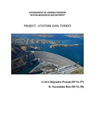
  • 9. welfare, the Government hopes to discourage separatism and to ‘harmonize’ the social and political identity of the region with the rest of Turkey. Lastly, GAP aims to support urban and industrial development also in other parts of Turkey, mainly in the west. The hydroelectricity to be produced in the GAP region is anticipated to far exceed any foreseeable demand by local industries, and most villages in the region were already served with electricity at the end of 1980s. Ataturk Dam: The Ataturk Dam is located on the Euphrates River in Bozova, south-east Turkey. Ataturk dam is the world's fourth largest rock fill dam which provides hydropower and irrigation in Turkey. The dam is constructed across the Euphrates River. The construction of dam began in 1983 and was completed in 1990. Initially it was called Karababa dam. It is named in honour of Mustafa Kenal Ataturk, the founder of the Turkish republic.
  • 10. The Euphrates receives most of its water in the form of rainfall and melting snow, resulting in peak volumes during the months April through May. Discharge in these two months accounts for 36 percent of the total annual discharge of the Euphrates, while low runoff occurs in summer and autumn. The average natural annual flow of the Euphrates has been determined from early- and mid-twentieth century records as 20.9 cubic kilometers at Keban, 36.6 cubic kilometers at Hīt and 21.5 cubic kilometers at Hindiya. The mean annual flow of the Euphrates (Firat) River is estimated to be 33.6 BCM. Some 98% of the Euphrates River runoff originates in the highlands of Turkey, while the rest of its catchment in lower arid regions makes little contribution to the river. The main features that distinguish the hydrologic regime of the Euphrates-Tigris River system are their annual and seasonal fluctuations, with large floods originating from the snow-melt in spring.
  • 11. Modifications to the Karababa /Ataturk Dam project over time In 1970, the Karababa Dam, later renamed the Ataturk Dam, was proposed on the site of the present dam. The Karababa Dam was presented in three alternative designs: the Low, Middle, and High Karababa Dam. These differed significantly in design, with heights of 85, 112, and 169 m respectively. The Middle Karababa Dam design was the most highly recommended. The Low Karababa Dam alternative was never seriously considered, and the High Karababa Dam would be more expensive, require high initial investments, face certain leakage problems, be vulnerable to any major flood wave, and have an enormous dead storage volume believed to be far greater than required. The Middle Karababa Dam was planned as part of the Lower Firat Project, which comprised four dams on the lower reach of the Turkish Euphrates River. These were the Karakaya, Low Golkoy, and Middle Karababa dams on the mainstream, and the Bedir Dam on a tributary river. The Middle Karababa Dam was planned to serve three main functions. • Firstly, it would be the only dam project to provide water to the planned irrigation area of 700,000 ha of the Lower Firat Project. On average,8600 million m^3 of irrigation water per year would be diverted from the reservoir through two separate conveyance systems to the Urfa-Harran, Lower Mardin, Siverek- Hilvan, Upper Mardin, and the Nusaybin-Cizre schemes. Irrigation water would be supplied during the dry season and late summer months in order to prolong the growing season.
  • 12. • Secondly, the Middle Karababa Dam would generate electricity with an installed power capacity of 800 MW. At full irrigation, the average annual energy output would be 3325 GWh. Most of the electricity would be transmitted to other parts of Turkey; only a smaller share would be supplied locally. • Thirdly, the dam would benefit downstream users by releasing an almost uniform regulated flow, which would reduce the river’s high annual flow variation and virtually eliminate the floods that occur in April and May of most years. • Lastly, it would create opportunities for the transportation of goods, envelopment of fisheries, and “other corollary uses”. Adoption of the High Karababa Dam The formulation of GAP in 1977 necessitated a revision of the original Lower Firat Project. By excluding the Low Golkoy Dam of 500 MW and adding two turbines and 57 m to the Karababa Dam height, the generation capacity of the Karababa Dam increased from 800 to 2100 MW. Moreover, the total planned irrigation area was to be extended to 800,000 ha, by revising and complementing the Lower Firat irrigation scheme with two new irrigation schemes, namely the Adiyaman-Katha and Baziki-Suruc schemes. The expected high cost of this expansion motivated the adoption of the High Karababa Dam, which was now considered more economic than the Low Golkoy and Middle Karababa dams together. As a result, the Middle Karababa Dam was rejected in favour of the High Karababa Dam alternative. The proposed Low Golkoy Dam was no longer needed, and the Bedir Dam and pumping plant were also excluded. Instead, a new dam downstream of the High Karababa Dam was proposed, the
  • 13. Birecik Dam. In total, the Euphrates River would be impounded by three mainstream dams below the existing Keban Dam: the Karakaya, High Karababa, and Birecik Dams. A number of smaller tributary dams were also proposed. The High Karababa Dam was planned to irrigate the total planned 800,000 ha in the Euphrates River basin within the region, through three separate tunnels. Ataturk Dam and hydropower scheme Key data 1. Hydrology Catchment area …………………………..92,240 km^2 Annual inflow …………….………………26,585 MCM 2. Reservoir Retention water level ……………………..EL 542.0 m Minimum operating level….. …………….EL 526.0 m Maximum water level………….. ………...EL 544.15 m Active storage ……………………………..12,700 MCM Reservoir capacity …………………………48,700 MCM Reservoir area ……………………………..817 km^2 3. Diversion structures Number of tunnels, concrete-lined…………. 3 No’s Length ……………………………………….4, 100 m Diameter ……………………………………. 8.0 m Discharge capacity………………………….. 3,900 m3 /s
  • 14. 4. Dam Type ……………………………………..Rock-fill with central core Height above lowest foundation ………..169 m Crest length…………………………….. 1,664 m Elevation of top of dam …………………EL 549.0 m Volume of dam ………………………….84.5 MCM 5. Spillway Type …………………………………….. Controlled overflow spillway Type of gates ………………………………6 radial gates Size of gates ……………………………….16 m × 18 m Discharge capacity …………………………16,800 m3 /s 6. Power intake Type ……………………………………Concrete gravity dam, 8 blocks Type of gates …………………………..8 roller gates Size of gates ……………………………7.5 m × 7.5 m 7. Penstocks Number of penstocks …………………8 Length……………………………… Between 515 and 640 m Diameter ………………………………7.25 m 8. Powerhouse Location …………………………..Adjacent to the dam toe Size (l × w × h) ……………………257 m × 53 m × 49 m Net head ……………………………151 m
  • 15. Valves …………………………….8 Butterfly Turbines…………………………. 8 Francis Rated space …………………….....150 rpm Turbine discharge …………………1,748 m 3 /s Installed capacity………………….. 8 × 300 = 2,400 MW Annual energy total ……………….8,900 GWh
  • 16.
  • 17. Settlement of dam The construction of the dam was started with the construction of the upstream coffer dam beginning of September 1985. The construction of the main body of the dam itself was started by December 1986, and completed in only 3 years and 8 months, which is much less than the originally estimated 5–5.5 years, by August. The fill of the dam contains high plasticity clay for the impervious zone, natural and processed alluvium for the filter zones, basalt and placated lime-stone for the shell zones. As the reservoir level started to rise, settlement problems started to occur along the crest reaching considerable levels by May 1992 and the weathered vesicular basalt used in the rock-fill section of the dam started to slake seriously. The elevation of the crest has fallen down to such an extent that now the upper part of the dam is being reconstructed to the original height of 549 m in
  • 18. order to maintain the 7 m freeboard and keep the dam operational. The settlement and slaking problems of the dam were investigated both in the field and the laboratory using soil and rock mechanical techniques. Standard proctor tests were run to determine the optimum moisture content at which the highest dry density (best compaction) is obtained during compaction of the impervious clay core. Consolidation tests were performed on undisturbed compacted clay core samples to determine if the field compaction of the clay core was done to the standards determined in the laboratory. Unconfined compression tests were run on the two different (sound aphanitic and weathered vesicular) basalts used in the rock-fill section of the dam to determine their unconfined compressive strengths. Slake durability tests were run on the same basalts to determine their durability under wetting and drying cycles. Petro graphic and X-ray analysis were done so as to study the mineralogical contents of the two basalts and in turn, to determine the cause of rapid slaking of the vesicular textured weathered basalt. The consolidation test results show that, the field compaction of the impervious clay core of the dam was not done to the standards determined through the proctor tests in the laboratory. The unconfined compressive strength of the sound aphanitic basalt is more than ten times greater than the weathered vesicular basalt, and while the former has extremely high durability the latter only has medium durability. Because of nontronite (iron montmorillonite) and secondary calcite amygdules filling the vesicles, the weathered vesicular basalt used in the rock-fill section is slaking badly causing additional settlement and landslides both in the clay core which is already settling and the rock-fill section of the dam. With the continuing slaking, the present reconstruction of the crest up to the theoretically intended height of 549 m to maintain the 7 m freeboard and keep the dam operational seems only to be a temporary solution.
  • 19.
  • 20.
  • 21. Employment during construction Employment opportunities in the GAP region have been historically limited because of limited economic development. With the beginning of the construction of the Ataturk Dam and the associated hydraulic infrastructure, the area became a magnet for people seeking employment, from both within and outside the region. The private sector companies that carried out all the construction suddenly opened a new vista for employment for skilled and non- skilled personnel. The contractor for the construction of the Ataturk Dam and HP was ATA Insaat Sanayi ve Ticaret AS. The construction of the dam started in November 1983 with only 89 workers. The total number of workers employed during construction of the dam was 16 431, of whom 466 were technical staff, and the rest skilled and unskilled workers (nearly 1000 of them sub-contracted). Between November 1983 and May 1996, there was an average of 3100 persons/month of work.
  • 22. The technical and skilled staff came to the region from other parts of Turkey, as local people had neither the knowledge nor the skill to construct such a large and complex structure. Most of the skilled workers who migrated to the dam site had gained their knowledge and experience during the construction of other similar structures such as the Keban, Karakaya and Altintas Dams. Local people represented 95% of all the workers employed, but all of them were initially recruited as unskilled employees. The Directorate of Machinery trained many unskilled personnel, who later worked as drivers, machinery operators (light, medium and heavy), carpenters, turners, metal workers, etc. The number of people working on construction of the dam increased steadily with time. As noted earlier, the number of employees in November 1983, when the construction started, was 89 but a year later, by October 1984, the number had increased to more than 1000 workers. At the peak of construction, which was reached in October 1988, the number of workers was 7688. The number started to decline steadily thereafter, and had decreased by half in about two years. By May 1996, the number had reduced to only 281 workers. The estimated number of people hired during the construction of the Ataturk Dam was 16,400. If this number is multiplied by a factor of 7 (average number of persons per family in south-east Turkey), some 114 800 people living in the region were sustained by the income generated by the employment created during construction of the Ataturk Dam.
  • 23. LAND ACQUISITION AND RESETTLEMENT The Ataturk Dam as being the largest sub-structure of the GAP have been affected a large area and many people. Its reservoir affects 143 villages. Approximately 45,000 people have been influenced by the project in some way according to the registration, population documents and etc. Some of those people may have been the ones that migrated to the big cities due to the negative economical conditions and still had some registered land in the project region. Ataturk Dam Expropriation which is the largest expropriation project of Turkey governs 81,700 hectares of land. The expropriation process of Ataturk Dam was carried by General Directorate of State Hydraulics between 1983 and 1996. Totally the expropriation compensation of 25,700 parcel (43,400 ha) which approximately equals a value of 494 Trillion TL (in 2004 unit prices) have been paid to the owners. Also people, who thought that the compensation payment is underestimated, have sued General Directorate of State Hydraulics to increase the compensation payment. These payments that belong to the ended suits are approximately 163 Trillion TL (in 2004 unit prices). . The Directorate of Rural Affairs has estimated that 1129 families had to be displaced because of the Ataturk Dam project during the period 1988 to 1997.Out of this number, 44% were to be resettled in rural areas, and the balance of 56% in urban areas. 100% of the population had been fully compensated, but only 30% of the population had been resettled (344 families), and 70% still had to be resettled (369 families in rural areas, and 416 families in urban areas). It is estimated that an average family consists of 10 persons. However, the records of DSI do not include the total number of families that have to be resettled. The records note only that the number of families that were involuntarily resettled from
  • 24. 1988 to July 2000 was 344 (133 in rural areas, and 211 in urban areas), and that the number of families waiting to be resettled is rural areas was 333. The families to be resettled in urban areas were not included. New Economic Activities It was natural that several new economic activities were generated during the construction and operation of the Ataturk Dam and the associated hydraulic infrastructures. Among these activities were fishing and fishing-related industry (boat-building, fishing-net construction and repair, fish processing and marketing,etc.), agricultural production through pumped irrigation directly from the reservoir, transportation through ferry boats in the reservoir, tourism (new hotels and restaurants); developments in the agro-industrial and industrial sectors, etc. Fishing and Fishing-related Industries The south-east region of Turkey is arid. Accordingly, most of the agriculture practiced is still rain-fed, and fishing and fishing-related activities were basically unknown to most people before the construction of the dam and the reservoir. The GAP Administration and DSI are aware of the economic, social and environmental impacts, both positive and negative, that may directly occur as a result of the construction of water projects in general. One of the important tasks of DSI as a planning and implementing agency is to advise local populations as to how best to take advantage of the newly available water resources for their own benefit as well as for the benefit of the communities concerned. These include income-generating activities, use of new varieties of
  • 25. food that were not locally available earlier, improvements in water supply and sanitation facilities, crop diversification and increase in agricultural yields, promotion of fishery, etc. DSI is also the institution that is responsible for carrying out activities related to water conservation and maximizing the economic benefits from the water projects. The assessment of the impacts of the reservoir included its characterization; limn logical studies, fish production, recreational activities, etc. In the case of the Ataturk Dam, the Department of Operations and Maintenance, Water Products Branch of DSI, prepared an Assessment of Water Products and Fishing Ground in the Ataturk Dam Lake (DSI, 1995). Among the main objectives were definition of the characteristics of the lake, study of the flora as well as any structure that would be covered by the water in the reservoir, conduct of the necessary limn logical studies, estimation of fish production in the reservoir, including stock assessment and feeding requirements, establishment of a Water Products Station, and provision of necessary support to establish a cooperative for Fishermen. The fieldwork on which the assessment was based was carried out between May 1992 and March 1993. Laboratory work was conducted between July and November 1993, and the report was completed in 1994. Limn logical studies in the dam concluded that there was no fish of economic importance in the reservoir. The stock of existing species was very low and there were considerable problems in terms of hatching. Accordingly, it was decided to introduce large fish populations (especially carp) in the reservoir, using 5–6 cm fingerlings from the Elazig-Keban Water Products Centre. In 1991, 200 000 carp fingerlings were released into the lake. The number of fingerlings released increased subsequently to 6,00,000 in 1992, and then to 20,00,000 each year in 1993 and 1994. On the basis of data currently available, it appears that the density of fish in the Ataturk Reservoir is less than has been observed in the Karakaya and Keban reservoirs. This is to be expected and is primarily due to the fact that the Ataturk reservoir is
  • 26. new and thus the amount of nutrients available for .sh production is low. On the basis of investigations carried out by DSI, the fish stock in the Ataturk Reservoir was about 850 tons/year when the assessment referred to earlier was carried out. This stock comprised mainly varieties such as biyikli, bizir, in, sis, cultured carp, fresh water scud, and bass. According to the DSI reports, there are many bays in Adiyaman at present in the Ataturk Reservoir. The report noted that it should be possible to establish successfully cage fishing in these bays. In fact, cage fishing is considered to be an important potential economic activity for people living near the reservoir. However, this may have some water-quality implications which need to be considered carefully. Irrigated Agriculture Before the irrigation started, the main crops of the region were wheat and barley. In 1995, about 30 000 ha were irrigated with cotton as the main crop. By 1997, Evaluation of Impacts of the Ataturk Dam 459 approximately 60,000 ha were cultivated with a gross agricultural output value (GAOV) of $125 million/year. The increase in cotton production has already spurred development in cotton-related agro-industries, such as cotton ginning, manufacture of cotton-seed oil, cloth mills, etc. Economic and social activities have further increased in Sanliurfa. An improvement in the lifestyle of the farmer’s benefited by irrigation in the plain is already visible. Development in Sanliurfa can be de.ned before irrigation and after irrigation.
  • 27. Industrial Activities As a direct result of developments stemming from the construction of the Ataturk Dam, industrial and commercial activities are accelerating rapidly in the region. The urban centers in the region have witnessed explosive growth in immigration because of enhanced employment potential, including self-employment. Construction activities have increased substantially, as have commercial activities for both formal and informal sectors. Transportation and communication links within the region, as well as between the region and the rest of Turkey, have opened up new potential for economic and industrial activities that simply did not exist earlier. Because of increasing demand, frequency of commercial flights between the urban centers of the GAP region and the rest of Turkey has expanded exponentially in recent years. Such increased and improved transportation and communication linkages are likely to enhance the socioeconomic development of the region at a rapid rate in the coming years. A good example of industrial and commercial development is Sanliurfa. The city has already established an industrial zone which is now almost full, as a result of which a second zone of about 11,000 decors is now being developed. A free zone for exports and imports would be developed in this second zone. The first zone is mainly occupied by agro-industrial activities that are cotton-related, e.g. cotton ginning, textiles, cotton-seed oil, etc. Prior to the construction of the Ataturk Dam, such activities were extremely limited. These agro-industries are not only generating employment that is improving the living conditions of many people but also are providing major value-added service products which were not available earlier. In the process, they are buying the raw materials from the farmers, which further boost the economy of the region. A secondary benefit of the new agro- industrial development is that the workers employed need housing, markets and
  • 28. other services which are boosting further the employment conditions of the region. The Ataturk Dam has thus directly contributed to a ‘win–win’ situation, whose socioeconomic benefits now encompass not only the GAP region but also the rest of the country through a variety of direct and indirect pathways. The GAP region is now at an early phase of industrial development. The levels of education and training that are now prevalent in the region are still significantly below the national average, though in recent years the gaps between the two have been closing. While at present a very significant number of unskilled laborers can be absorbed in the labour force, the region will increasingly need more and more skilled labour, if the sustainability of employment generation conditions is to be ensured. On the basis of the available evidence, it is clear that many of the unskilled labourers are progressive learning new skills, which increases their salaries and employment opportunities. Both of these are of course strong incentives to learn new skills. In spite of these advances, however, it is now clear that the region is already suffering from a shortage of skilled workers. As new industries are established and existing ones are modernized, demand for skilled labour will accelerate. This demand can be met by increasing the training facilities available in the region and by migration of skilled workers from other parts of Turkey to the region. This is likely to put inflationary pressure on wages for skilled labour, which could reduce one of the important economic advantages Turkey has at present. Equally, dependence on skilled workers from outside the region will assure that the workers in the region will be increasingly restricted to low-paid and undesirable jobs. This could create social tension between the low-paid local workers and highly paid employees coming from outside the region. Thus, viewed from any direction, the best solution would be to take appropriate and timely steps to increase the education and skills of the local workers. While increasing industrialization has ensured many benefits for the
  • 29. people of the region, it also is bringing in its wake certain social and environmental costs. The main concern at present is the negative environmental and social impacts of wastewater management practices. Proper wastewater treatment by any industry is now a rare exception rather than the norm. The situation is serious for the industrial zone in Sanliurfa because of the high concentration of industrial activities in the area. Even though the Sanliurfa industrial estate is 15 km away from the city, the continuation of indiscriminate discharge of wastewater could have major social and health costs in the coming years for a variety of reasons. First, even though Sanliurfa is at a reasonable distance from the industrial estate, groundwater in the area may become contaminated with industrial waste products over the years. Depending on the gradient of the flow, the region’s groundwater may become contaminated by industrial waste products, not just in Sanliurfa but in the various cities where industrial development is being encouraged. Second, the industrial estate may be 15 km away from Sanliurfa, but it is located near some villages and a nearby stream, which serves as a source of water for some people. The people and the ecosystems of the nearby villages are likely to bear the first adverse health and environmental impacts of the existing wastewater discharges. In the near term, monitoring of the quality of wastewater discharges and groundwater near the estate is necessary. Over the short to medium term, it is necessary to prepare and then implement a plan for wastewater treatment for the industrial zone. There was not time to analyze the wastewater situation in any depth. However, even if there had been, this would not still have been possible because of the absence of data on the quantity and quality of wastewater generated. However, prima facie, there appears to be a good case to construct a communal wastewater plant for the industrial estate. Some discussions have already taken place with the World Bank and the Islamic Development Bank for a possible loan to construct a wastewater treatment plant. A strategy for wastewater management
  • 30. for the industrial estate of Sanliurfa should now receive priority attention. This is because a second zone is in the process of establishment, which is likely to increase the magnitude of the overall problem. The experience with the Sanliurfa industrial zone project indicates that any new similar project in the region must consider a wastewater and solid waste management plan from the very beginning of the planning process. References • http://www.greenstrategy.se/wp-content/uploads/2013/05/Brismar- NRF.pdf • Impact of the Ataturk Dam Lake on Agro-Meteorological Aspects of The South-eastern Anatolia Region Using Remote Sensing and GIS Analysis • https://www.britannica.com/topic/Ataturk-Dam • https://pdfs.semanticscholar.org/2050/e31f75c776feef498a3c66b790b95347 5cef.pdf