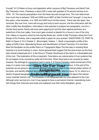
FucueE 10.13 Pattern of tcour and deposition within canyons of Big Thompson and North Fork.
Big Thampson rivers. Floedway is about 200 in wide with grastats of 24 percent ishroba et al,
1979 . 19. The heavist peecipitation from this fload secured enough time. The river determines
how much time is between 1930 and 2040 hours MDT at Glen Comfort and "enough"; it may be a
few years, a few decades, or a 1930 and 2200 hours at Clen Haven. There was lute oppor. few
centuries. But over time, rivers will occupy and turity to wam anyone. Uie this intormation with the
other modify their floodplains. information in this exercise to prepare two paragraphs, one On a
shorter tiene period, floods will cover parts apguing for and the other againet parchave of a
waterfront of the tiver valley. How much gets covered is deterlot for a houne in one of the miny
river valleys er canyons mined by how big the floods are. similar to Big Thompson along the Front
Range of the Fockies. Uae a aeparate sheet is paper for your anwwer. QUESTIONS (10, PART D)
Refer to Figure 2.10 in Chapter 2 . Blooningted, Indiana. 1. Sketh a toposraphic profile of the
valley of Griffy Creck. Meandering Rivers and Identification of Flood Township 16 in the East.
Mark the floodplain oe the profile Plains on Topographic Maps The first step in avoiding flood
hazards is to avoid building in rivers. Some geoscientists suggest that the area known as the food
plain should instead jast be 2. Is the Drive-in Theater (Southwest of the dami) in a floodcalled part
of the river. The implication of this is important. Food plains are natural parts of river syotems that
do not happen to be covered by water alf of the time. When flood plains are covered by watec,
however, the damage to unprepared (and in some 3. E Payne Cemetery (east-central part of the
mapy in a cases even prepared) people and communities can be disastrous. In this part of the
exescise we are going to use several diffenent topographic maps in the colored plates section of
the book, and identify differtent flood plains on the maps. First, refer to Figure 10.14, which is a
sketch of typical topographic features seen along a flood plain. Note on this figure that natural
rivens meander (bend) a lot. The floodplain is the topograptically low area adjacent to the river.
Although when we look at a river it may appeat to have a permanent charnel, meandering rivers
will change their channels and erode and redeposit over their entire floodplain, givem.
FucueE 1013 Pattern of tcour and deposition within canyons .pdf
1. FucueE 10.13 Pattern of tcour and deposition within canyons of Big Thompson and North Fork.
Big Thampson rivers. Floedway is about 200 in wide with grastats of 24 percent ishroba et al,
1979 . 19. The heavist peecipitation from this fload secured enough time. The river determines
how much time is between 1930 and 2040 hours MDT at Glen Comfort and "enough"; it may be a
few years, a few decades, or a 1930 and 2200 hours at Clen Haven. There was lute oppor. few
centuries. But over time, rivers will occupy and turity to wam anyone. Uie this intormation with the
other modify their floodplains. information in this exercise to prepare two paragraphs, one On a
shorter tiene period, floods will cover parts apguing for and the other againet parchave of a
waterfront of the tiver valley. How much gets covered is deterlot for a houne in one of the miny
river valleys er canyons mined by how big the floods are. similar to Big Thompson along the Front
Range of the Fockies. Uae a aeparate sheet is paper for your anwwer. QUESTIONS (10, PART D)
Refer to Figure 2.10 in Chapter 2 . Blooningted, Indiana. 1. Sketh a toposraphic profile of the
valley of Griffy Creck. Meandering Rivers and Identification of Flood Township 16 in the East.
Mark the floodplain oe the profile Plains on Topographic Maps The first step in avoiding flood
hazards is to avoid building in rivers. Some geoscientists suggest that the area known as the food
plain should instead jast be 2. Is the Drive-in Theater (Southwest of the dami) in a floodcalled part
of the river. The implication of this is important. Food plains are natural parts of river syotems that
do not happen to be covered by water alf of the time. When flood plains are covered by watec,
however, the damage to unprepared (and in some 3. E Payne Cemetery (east-central part of the
mapy in a cases even prepared) people and communities can be disastrous. In this part of the
exescise we are going to use several diffenent topographic maps in the colored plates section of
the book, and identify differtent flood plains on the maps. First, refer to Figure 10.14, which is a
sketch of typical topographic features seen along a flood plain. Note on this figure that natural
rivens meander (bend) a lot. The floodplain is the topograptically low area adjacent to the river.
Although when we look at a river it may appeat to have a permanent charnel, meandering rivers
will change their channels and erode and redeposit over their entire floodplain, givem