
Recommended
Recommended
More Related Content
Similar to Geospatial Mapping and Analysis of the Distribution of Public Primary Healthcare Centers in Kaduna State, Nigeria.
Similar to Geospatial Mapping and Analysis of the Distribution of Public Primary Healthcare Centers in Kaduna State, Nigeria. (20)
More from ijtsrd
More from ijtsrd (20)
Recently uploaded
Recently uploaded (20)
Geospatial Mapping and Analysis of the Distribution of Public Primary Healthcare Centers in Kaduna State, Nigeria.
- 1. International Journal of Trend in Scientific Research and Development (IJTSRD) Volume 7 Issue 5, September-October 2023 Available Online: www.ijtsrd.com e-ISSN: 2456 – 6470 @ IJTSRD | Unique Paper ID – IJTSRD60069 | Volume – 7 | Issue – 5 | Sep-Oct 2023 Page 1001 Geospatial Mapping and Analysis of the Distribution of Public Primary Healthcare Centers in Kaduna State, Nigeria Peter Danjuma Averik, Andrew Adesola Obafemi, Gladys Chineze Emenike Department of Geography and Environmental Management, University of Port Harcourt, Port Harcourt, Nigeria ABSTRACT This study investigated the geospatial analysis and mapping of the distribution of public primary healthcare centers (PPHCs) in Kaduna State, Nigeria. The study adopted a cross-sectional survey design and employed purposive and systematic random sampling techniques to select three LGAs in each of the three Senatorial zones of Kaduna State. At the State (Subnational), Senatorial, and Local Government Areas (LGAs) levels, a three-step hierarchical geospatial analysis was carried out using nearest neighbor analysis. The coordinates of the PPHCs that the Global Positioning Systems had gathered in the study area were used in the study. In order to determine the distribution pattern of the PPHCs, additional analysis was performed using the coordinates imported into the ArcGIS interface. While the nearest neighbor analysis was used to examine the distribution, patterns present in the location of the PPHCs, descriptive statistics were used to describe the nature of the distribution. Findings showed that at significant spatial scales, the point pattern of PPHCs was random in Kaduna State (z=1.046; p=0.296); Kaduna North Senatorial Zone (z=0.215; p=0.82); Kaduna Central Senatorial Zone (z=1.387; p=0.165) and Kaduna South Senatorial Zone (z= 1.093; p=0.274), while at the LGA level variations were observed with a few clustered and dispersed and yet majority showed random distribution. The World Health Organization's recommendation of 5km for distances between and among PPHCs was exceeded at all levels, according to the Nearest Neighbor Analysis. For instance, the observed mean distance for the senatorial pattern is 5.28 km, 7.29 km, and 7.14 km, respectively, for the senatorial zones of Kaduna North, Kaduna Central, and Kaduna South. According to the study's findings, the distribution pattern was skewed and suggested a non-proportional type. Therefore, it is recommended that additional electoral wards should be created or PPHCs should be built in the underserved LGAs while taking the center's accessibility and population density into consideration. How to cite this paper: Peter Danjuma Averik | Andrew Adesola Obafemi | Gladys Chineze Emenike "Geospatial Mapping and Analysis of the Distribution of Public Primary Healthcare Centers in Kaduna State, Nigeria." Published in International Journal of Trend in Scientific Research and Development (ijtsrd), ISSN: 2456-6470, Volume-7 | Issue-5, October 2023, pp.1001-1015, URL: www.ijtsrd.com/papers/ijtsrd60069.pdf Copyright © 2023 by author (s) and International Journal of Trend in Scientific Research and Development Journal. This is an Open Access article distributed under the terms of the Creative Commons Attribution License (CC BY 4.0) (http://creativecommons.org/licenses/by/4.0) KEYWORDS: Accessibility, Environmental Health, Geographic Information System, Spatial Justice, Sustainable Development and Ward Health System 1. INTRODUCTION Sustainable development depends on and results from good health. Everyone should be able to fully enjoy their right to health as a fundamental human right in order to lead socially and economically productive lives (FRN, 2020). Worldwide health systems still fall short of offering care that is easily accessible, of high quality, all-inclusive, and integrated. There is growing interest in primary health care utilization and access in developing countries as the global health community sets ambitious goals of universal health coverage and health equity in accordance with the 2030 agenda for sustainable development (UN DESA, 2022). To plan and support interventions for complex healthcare system, systems, a wide range of stakeholders, including development organizations, global funding agencies, policy planners, and decision-makers need a better understanding of primary healthcare systems (WHO, 2017a). As a result, there is a need to close the knowledge gaps regarding strategic data on national and subnational levels in developing countries related to front-line primary healthcare systems (WHO, 2017b). The complexity of ensuring universal health is exacerbated by population dynamics because the task IJTSRD60069
- 2. International Journal of Trend in Scientific Research and Development @ www.ijtsrd.com eISSN: 2456-6470 @ IJTSRD | Unique Paper ID – IJTSRD60069 | Volume – 7 | Issue – 5 | Sep-Oct 2023 Page 1002 is constantly changing due to population change. In order to effectively address changes in population growth, composition, and distribution, health systems must adapt. How to balance community epidemiological needs with how they relate health to population dynamics is the challenge facing policy- makers in the health sector. To achieve this, they must democratize the healthcare systems by delegating power to district-based healthcare organizations that can better serve the needs of local communities. All health, population, and development policies must have as their primary objective listening to people and taking into account their concerns in service delivery, research and development, and resource allocation (WHO, 1993). Primary healthcare systems are designed to serve a specific population and are a major concern for the world's population, which is primarily growing in developing nations. As a result, there may come a time when the infrastructure and public facilities in place are unable to adequately serve the population that is constantly growing (Shrestha, 2010; MHFW, 2020). Population growth places a heavy strain on infrastructure, particularly healthcare facilities, which in turn overstretches staffing levels (Clairin, 1992; Lambo, 2007). The state of health facilities and facilities should be constantly monitored for improved service delivery and viable improvement in the standard of life of the citizenry, as spatiotemporal variability in population is a result of natural increase and migration. According to the WHO, the evaluation and discussion of population patterns must be an integral part of health planning (WHO, 1993; Egwemi, 2010). In agreement with WHO, the United Nations declared that everyone has the right to a standard of living that is sufficient for their own health and the welfare of their families, including access to food, clothing, housing, medical care, essential social services, and public employment in their country. If the right to health is violated, it can frequently make it more difficult to exercise other human rights, like the right to an education or the right to a job, and vice versa (UN, 2015; WHO, 2008; OHCHR, 2002). Okafor (2008) noted that treating people and places equally can sometimes be unfair and unjust; equity requires treating everyone equally under the same circumstances, even when those circumstances may justify allocating resources inequitably. In other words, it is just, fair, and equitable to distribute resources (such as healthcare services) unevenly depending on the situation or degree of need. If spatial inequality is not guided by the equity principle, i.e., if it is not a reflection of spatial variations in need, then spatial inequality is equivalent to spatial injustice. Geographic Information Systems (GIS) have made it possible to measure geographic accessibility for the past 20 years. It has long been used to manage the vast geospatial data sets about the locations and intensities of environmental hazards as well as to map the uneven spatial distribution of those hazards. Furthermore, Geographic Information Science (GISc) and spatial analysis techniques are particularly well suited to environmental health investigations and have had a significant influence on environmental health studies for many years (Maantay and McLafferty, 2011). Mansour (2016) also noted that GIS may be used to evaluate the geographic distribution of health services, particularly the efficacy of health facility coverage in relation to population density. According to the World Health Organization, environmental risk factors like pollution, chemical exposure, climate change, and ultraviolet radiation are responsible for more than 100 diseases and injuries (WHO, 2018). In order to understand how environmental factors, affect health, geography and spatial relationships are crucial (Maantay & McLafferty, 2011). Primary Healthcare is vital healthcare that is universally accessible to all people in the Community through their participation and at a cost that the Community and Country can afford to maintain at every stage of their development in the spirit of self- reliance and self-determination. It is based on practical, scientifically sound, and socially acceptable methods and technology. It is the first point of contact between individuals, families, and communities and the national health system, which aims to provide healthcare as close to people's homes and places of employment as possible. Better health for all is primary healthcare's ultimate objective. In the International Conference on Primary Health's declaration, this ideal healthcare model was adopted. The World Health Organization's mission of "Health for All" was founded on this ideal healthcare model, which was adopted in the declaration of the International Conference on Primary Health Care held in Alma Ata in 1978 (WHO, 1978) In the past, Nigeria ran the District Health System just like many other developing nations, particularly those in sub-Saharan Africa. However, in the latter, there was no distinct boundary and uniformity of the "district" because all LGAs divided themselves into what they considered to be districts. Because of this, the Federal Government of Nigeria revived the National Primary Health Care Development Agency (NPHCDA) and introduced the Ward Health System
- 3. International Journal of Trend in Scientific Research and Development @ www.ijtsrd.com eISSN: 2456-6470 @ IJTSRD | Unique Paper ID – IJTSRD60069 | Volume – 7 | Issue – 5 | Sep-Oct 2023 Page 1003 (WHS), which is the policy of allocating at least one functional PHC per electoral ward (10,000 to 30,000 people), in response to UNICEF and WHO's 1992 recommendation that "community mobilization would greatly be assisted" (WHO, 1992, FMoH, 1988, and NPHCDA 1990 cited in Abosede et al., 2012). In order to achieve UHC through community participation, as mandated by the National Health Act, Kaduna State adopted and put into practice the Ward Health System (NPHCDA 2010, 2018, FGN 2014, and FMoH 2016). As a result, the state, which has 255 electoral wards and 23 LGAs, has 255 "model" public PHCs, one in each ward. The private and public healthcare sectors coexist in Kaduna State's pluralistic healthcare delivery system. There are 5,263 healthcare facilities in Kaduna State, including public, private, and faith-based organizations, according to the state's 2018 Health Facility Census Report. 1,937 hospitals—secondary, primary, and health clinics—are among these facilities. Two hundred fifty-five (255) PHCs have received upgrades and modern equipment as part of the state's infrastructure development to enable them to offer round-the-clock services in accordance with the one (1) PHC per ward strategy (KDSDP, 2020; NPHCDA, 2010). In Kaduna State, however, in spite of the infrastructure and prior efforts on government-owned facilities, healthcare delivery is still below-optimal with many citizens lacking access to basic primary healthcare services due to unfair distribution (distributive injustice). Where these services were available, the quality remained a major concern and in some cases was very expensive and difficult for the communities' predominately low-income population to afford. Despite this outstanding development, the industry still faces infrastructure gaps. In terms of implementing Primary Health Care Under One Roof, the state placed sixth out of seven states in the North- West geopolitical zone, indicating poor health indicators (NPHCDA, 2015). Additionally, Kaduna State was found to be among the worst states in Nigeria for residents in need of healthcare, according to a report on the state of primary healthcare service delivery in Nigeria from 2019–2021. The report, which was on the analysis and ranking of health system performance across states, provided an overview of the 36 states of Nigeria's health delivery system as well as an assessment of each state's compliance with the National Health Act and National Health Policy (Sphcn, 2022). Furthermore, according to the Kaduna State Bureau of Statistics (KDBS) report for 2021, only 0.5% of Kaduna state's populace has access to sanitation services that are properly managed. Moreover, there is a lack of political commitment to effective health leadership and health development, particularly at the local government level. Both the health management information system and the referral systems are underdeveloped and do not include the private sector. There are no research budget lines, and neither the state nor the LGAs carry out health research (KDSG, 2010; KSDP, 2015). However, one of the most fundamental conditions for the placement and distribution of PPHCs is accessibility to PHCs. Health equity research rarely addresses location- related issues because it typically focuses on describing and analyzing how social determinants affect health outcomes (Pons-Vigués et al., 2014). The aforementioned suggests that Kaduna State's population access to primary healthcare facilities requires adequate attention and at the very least, nearly equitable distribution. 2. Related Work The United Nations Department of Economic and Social Affairs (UNDESA, 2022) observed that health systems around the World continue to fall short of offering accessible and all-inclusive healthcare. Therefore, the poor performance of the primary healthcare system has attracted several studies in most countries. Some researchers have made an effort to study accessibility to healthcare services and facilities at the national or regional level (Okafor, 1987; Adesanya et al., 2002; Adagbasa, 2008; Arokoyu & Weje, 2015). While most researchers carried out their studies at very small or local scales, rural or urban only (Aminu & Dinye 2014; Joshua et al., 2015; Agofure & Sarki, 2017; Abubakar & Adamu, 2020; Usman, 2020; Idoko, et al., 2021; Mshana et al., 2023). For instance, Ishaq (1994) studied the Impact of the Primary Health Care Delivery Policy in Zaria L.G.A of Kaduna state. Olajuyin et al., (1997) investigated the effect of location on the utilization of healthcare centers in the Irewole local government area of Osun State, Nigeria. Massoud (2007) conducted research on the Implementation of the Primary Health Care Delivery System in Birnin-Gwari L.G.A, Kaduna State. Abbas (2009) did an analysis of the accessibility and utilization of healthcare facilities in Kachia Local Government Area of Kaduna State. Abbas, et al., (2012) investigated the spatial distribution of healthcare centers in Chikun local government area of Kaduna state, Nigeria using the Geographic Information Systems (GIS) technique in healthcare management planning. Njoku and Akpan (2013) in their study evaluated the locational efficiency of available health facilities in Ikot-
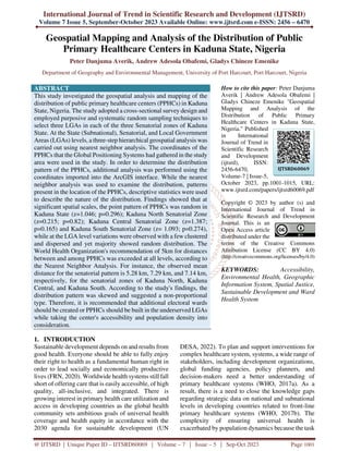
- 4. International Journal of Trend in Scientific Research and Development @ www.ijtsrd.com eISSN: 2456-6470 @ IJTSRD | Unique Paper ID – IJTSRD60069 | Volume – 7 | Issue – 5 | Sep-Oct 2023 Page 1004 Ekpene LGA, Akwa Ibom State to ascertain the distributional pattern of the healthcare centers in the study area. These studies did not consider the use of geo-information to generate the distribution pattern of healthcare at the subnational scale. Michael & Alonge (2021) conducted a qualitative analysis of the “One PHC per ward” in Ekiti state, Nigeria not from a geographical perspective but a sociological point of view. While Lawal & Anyim (2019) researched modelling geographic accessibility to all types of PHC facilities in Akwa Ibom state in the Niger Delta region of Nigeria and produced a Map. To date, it has been repeatedly demonstrated that substantial subnational spatial variations in the delivery and utilization of healthcare are concealed by national or regional aggregate data (UNDP Nigeria, 2016). Consequently, data from studies conducted at the national or regional levels are frequently inappropriate for state and local policymaking and intervention. The data at the LGA scale is also insufficient for planning PPHCs and services at the state level. Furthermore, there has not been much research done into the specific geographic patterns and accessibility of Kaduna State's health facilities. As a result, the state (subnational) level of this study's analysis focused on the nature of variation in the distribution and accessibility of PPHCs on a hierarchical scale at the state (subnational), senatorial, and LGA levels with maps. 3. Study Area The research area was Kaduna state and is between latitudes 09o 02' N through 11o 32' N and longitudes 06o 15' E through 08o 38' E. (See below Figure 3.1 for the Map of the study area). It is a highly populated (third in the country) area with a population of 6.06 million (2006 census), and at the end of 2020, the state's population is estimated at 9,476,053; and geographically large (45,711.2 km2 ), is well-suited for the analysis and geospatial mapping of the distribution of PPHCs (NPHCDA, 2015; KDSG, 2010 & 2012; KDSDP, 2020; NPC, 2009). The state was created on May 27, 1967, and occupies part of the central position of the Northern part of Nigeria (with Kaduna as its capital) and the North-West geo-political zone. It shares common borders with Katsina State to the North, Nasarawa State and the Federal Capital Territory, Abuja to the South, Kano, and Bauchi States to the Northeast, Zamfara State to the Northwest, Niger State to the West, and Plateau State to the Southeast. Administratively, the study area has 3 senatorial zones, 23 LGAs, and 255 electoral wards. The population is culturally very diverse with distinct differences in religion, ethnicity, traditions and social norms between the predominantly Hausa/Muslim population in the northern part of the State and Christians of a variety of ethnic groups to the south. Over 60 ethnic groups namely, Adara (Kudara), Atyap (Kataf), Bajju (Kaje), Fulani, Gbagyi (Gwari), Gwandara, Gwong (Kagoma), Ham (Jaba), Hausa, Igbo, Ninkyop (Kaninkon), Ninzo, Numana, Nyenkpa (Yeskwa), Oegworok (Kagoro), Tsam (Chawai) and Yoruba among others populate the state (KDSG 2010 and 2017; Hayab, 2015). Figure 1: Kaduna State showing the 23 Local Government Areas (study area) Source: Adapted from the Administrative Map of Kaduna State
- 5. International Journal of Trend in Scientific Research and Development @ www.ijtsrd.com eISSN: 2456-6470 @ IJTSRD | Unique Paper ID – IJTSRD60069 | Volume – 7 | Issue – 5 | Sep-Oct 2023 Page 1005 The entire Kaduna state is underlain by a basement complex of igneous and metamorphic rocks of mainly Jurassic to Pre-Cambrian ages. The basement complex rocks are essentially granites, gneisses, migmatites, schists, and quartzites (Benett, 1979;13 cited in Kaduna North, 2003 Wikipedia). The typical red-brown to red- yellow tropical ferruginous soils and savannah grassland with a few scattered trees and woody shrubs make up the soils and vegetation in this region (Ogbozige et al, 2018). The vegetation is divided into two areas: the southern Guinea and northern Guinea savannahs (Abaje, 2007). The tropical dry-and-wet type of climate found in Kaduna State is classified as Aw by Koppen's. The dry season runs from mid-October of one calendar year to April of the following, while the wet season is from April through mid-October with a peak in August (Abaje, et al., 2015). The state as a whole receives about 1323mm of rainfall on average annually (Oladipo, 1993). 4. Method and Materials This study adopted a cross-sectional survey design and employed purposive and systematic random sampling techniques to select three LGAs in each of the three Senatorial zones of the study area. The main GIS-based procedures included geo-referencing, which involved scanning and importing the administrative map of the study area into the ArcGIS 10.3 version of software. By using geo-referencing, we can connect a coordinate reference system to a space object or raster object that hasn't been associated with a location. This makes it possible to combine different independent GIS datasets as an overlay of geographic data. The scanned map was therefore geo-referenced. The geo-referenced map was digitized on-screen under the following themes: Local government areas and the political ward as polygon, LGA and ward boundary as lines, and road. The second major process was digitizing whereby the geo-referenced map was digitized on-screen under the following themes, the Local government areas and the political ward as polygon, LGA and ward boundary as lines and road network as lines. All attribute data for the primary health care facilities obtained from the various health care management through inventory using the checklist were typed in Microsoft excel and saved as CSV (comma deliminated) format for analysis. Attribute data are acquired data resources often organized in a database format, usually in tabular form and stored in a database management system. The geographic coordinates of the PPHCs in Kaduna state were collected using the handheld GPS (Averik, et al., 2023). The coordinates were structured into Microsoft Excel and exported into ArcGIS 10.3 interface. As such, all the shape files holding the relevant data layers were then spatially overlaid to create a combination of visual map of polygon, line and point feature classes. The study further built on the output map of the PPHCs distribution to determine the spatial pattern. Hence, the Nearest Neighbor Analysis (NNA) inferential statistical tool in ArcGIS10.3 was used to investigate the spatial pattern in the data. This tool automatically calculated for the LGAs the average nearest neighbor ratio by dividing the observed average distance by the expected average distance. NNA is the method of exploring pattern in the location data by comparing mean distance (Do) of phenomena to the same expected mean distance (De) usually under random distribution. The locations of the public PHCs were used to determine whether the spaces are concentrated or evenly distributed. The NNA formula is as follows: The NNA will always have or return five (5) values; observed mean distance (Do), expected mean distance (De), nearest neighbor ratio, z-score, and p-value. A negative Z-score indicates clustering, while a positive Z-score means disperse or evenness. Moreover, the Z-score usually returns a range of values between -2.58 to 2.58. Therefore, a negative Z-score less than -2.58 indicates a significant clustering at 0.01 probability level. On the other hand, a positive Z-score greater than 2.58 indicates a significant regularity or dispersal at 0.01 probability level (Getis and Ord 1998). The NNA is observed at three (3) scales; State, Senatorial zones and LGAs knowing that scale of observation can influence the point pattern of distribution. 5. Results and Discussions The Spatial distribution of PPHCs is presented using hierarchical scale Maps from State, Senatorial and LGAs as follows;
- 6. International Journal of Trend in Scientific Research and Development @ www.ijtsrd.com eISSN: 2456-6470 @ IJTSRD | Unique Paper ID – IJTSRD60069 | Volume – 7 | Issue – 5 | Sep-Oct 2023 Page 1006 Figure 2: Kaduna State showing the distribution of PPHCs. Figure 3: Kaduna North Senatorial Zone showing the distribution of PPHCs
- 7. International Journal of Trend in Scientific Research and Development @ www.ijtsrd.com eISSN: 2456-6470 @ IJTSRD | Unique Paper ID – IJTSRD60069 | Volume – 7 | Issue – 5 | Sep-Oct 2023 Page 1007 Figure 4: Kaduna Central Senatorial Zone showing the distribution of PPHCs Figure 5: Map Kaduna South Senatorial Zone showing the distribution of PPHCs
- 8. International Journal of Trend in Scientific Research and Development @ www.ijtsrd.com eISSN: 2456-6470 @ IJTSRD | Unique Paper ID – IJTSRD60069 | Volume – 7 | Issue – 5 | Sep-Oct 2023 Page 1008 Figures 2, 3, 4, and 5 show the visual distribution of PPHCs in Kaduna State and the three senatorial zones. The primary healthcare centers are not equitably and equally distributed across the study area with clustered distribution of these centers in Kaduna North and Kaduna South LGAs, this might be attributed to the denser population and urbanization. This goes in line with Lou and Wang (2009) that said a series of locational factors may be responsible for the distribution of Health Care facilities in an area, the factors may include: population size, availability of good roads, mode of transport, etc. Also, this agrees with the findings of Abbas et al., (2012) which revealed that there was inequality in the distribution of healthcare facilities in Chikun LGA of Kaduna State. The public health centers were found to be clustered along the Eastern part of Chikun LGA in Kamazou, Kujama, Kakau, and Sabon Gaya districts while 6 (33.4%) of the public health centres were found in the southern part of the study area in Chikun and Gwagwada districts and none existed at the northwestern part of the study area. A similarity can also be drawn with the study conducted by Ismail et al., (2014) that revealed uneven distribution of health facilities in Giwa LGA of Kaduna state and Tofa LGA in Kano State. 5.1. Point Pattern of Spatial Distribution The pattern of PPHCs distribution for the twenty-three (23) LGAs are in our work (Averik, et al., 2023), while the pattern of PPHCs distribution and the average nearest neighbor summary for Kaduna state, the three (3) Senatorial zones and the average nearest neighbor summary for the 23 LGAs are presented below; Table 2: Showing the Average Nearest Neighbor Summary for Kaduna state Observed Mean Distance: 6337.7871 Meters Expected Mean Distance: 6125.1234 Meters Nearest Neighbor Ratio: 1.034720 Z-score: 1.046008 P-value: 0.295557 ___________________ Source: Author’s Fieldwork, 2022. Given the z-score of 1.04600845106, the pattern does not appear to be significantly different than random. Figure 6: Pattern of distribution of PPHCs in Kaduna State. Source: Author’s Fieldwork, 2022. Table 3: Showing the Average Nearest Neighbor Summary for Kaduna North Senatorial Zone Observed Mean Distance: 5280.2070 Meters Expected Mean Distance: 5216.6301 Meters Nearest Neighbor Ratio: 1.012187 Z-score: 0.214956 P-value: 0.829802 ___________________ Source: Author’s Fieldwork, 2022.
- 9. International Journal of Trend in Scientific Research and Development @ www.ijtsrd.com eISSN: 2456-6470 @ IJTSRD | Unique Paper ID – IJTSRD60069 | Volume – 7 | Issue – 5 | Sep-Oct 2023 Page 1009 Given the z-score of 0.214956021769, the pattern does not appear to be significantly different than random. Figure 7: Pattern of Distribution of PPHCs in Kaduna North Senatorial Zone. Source: Author’s Fieldwork, 2022. Table 4: Average Nearest Neighbor Summary of PPHCs in the LGAs in Kaduna North Senatorial Zone S/No LGA NNA EMD (Meters) OMD (Meters) z-score p-value Remark 1 Ikara 1.320652 4867.6339 6428.4511 1.840290 0.065726 Dispersed 2 Kubau 1.120258 7545.1688 8452.5382 0.763031 0.445445 Random 3 Kudan 1.387313 3161.6655 4386.2211 2.343114 0.019124 Dispersed 4 Lere 1.365194 7002.0219 9559.1201 2.317134 0.020496 Dispersed 5 Makarfi 1.119391 3676.2367 4115.1445 0.722272 0.470127 Random 6 Sabon Gari 0.741291 2566.5768 1902.5807 -1.565100 0.117559 Random 7 Soba 0.856683 7124.8858 6103.7710 -0.909335 0.363173 Random 8 Zaria 1.200324 2353.3936 2824.8352 1.381770 0.167042 Random Source: Author’s Fieldwork, 2022. Table 5: Showing the Average Nearest Neighbor Summary for Kaduna Central Senatorial Zone Observed Mean Distance: 7290.7563 Meters Expected Mean Distance: 7952.2074 Meters Nearest Neighbor Ratio: .916822 Z-score: -1.387228 P-value: 0.165372 ___________________ Source: Author’s Fieldwork, 2022.
- 10. International Journal of Trend in Scientific Research and Development @ www.ijtsrd.com eISSN: 2456-6470 @ IJTSRD | Unique Paper ID – IJTSRD60069 | Volume – 7 | Issue – 5 | Sep-Oct 2023 Page 1010 Given the z-score of -1.38722754983, the pattern does not appear to be significantly different than random. Figure 8: Pattern of Distribution of PPHCs in Kaduna Central Senatorial Zone Source: Author’s Fieldwork, 2022. Table 6: Summary of Spatial Pattern of Near Neighbor Analysis of LGAs in Kaduna Central Senatorial Zone S/No LGA NNA EMD (Meters) OMD (Meters) z-score p-value Remark 1 Birnin Gwari 1.372924 12437.7346 17076.0585 2.256060 0.024067 Dispersed 2 Chikun 0.79956 9838.7326 7866.7163 -1.328290 0.184082 Random 3 Giwa 1.332850 8035.6011 10710.2549 1.801047 0.071695 Dispersed 4 Igabi 1.290995 8812.2582 11376.5794 1.928443 0.053800 Dispersed 5 Kaduna North 0.323911 3884.2823 1258.1608 -4.480490 0.000007 Clustered 6 Kaduna South 0.115970 9824.2735 1139.3253 -5.858525 0.000000 Clustered 7 Kajuru 1.195593 7849.1951 9384.4458 1.183273 0.236701 Random Source: Author’s Fieldwork, 2022. Table 7: Showing the Average Nearest Neighbor Summary for Kaduna South Senatorial Zone Observed Mean Distance: 7138.3177 Meters Expected Mean Distance: 6726.1799 Meters Nearest Neighbor Ratio: 1.061274 Z-score: 1.093363 P-value: 0.274234 Source: Author’s Fieldwork, 2022.
- 11. International Journal of Trend in Scientific Research and Development @ www.ijtsrd.com eISSN: 2456-6470 @ IJTSRD | Unique Paper ID – IJTSRD60069 | Volume – 7 | Issue – 5 | Sep-Oct 2023 Page 1011 Given the z-score of 0.09336308168, the pattern does not appear to be significantly different than random. Figure 9: Pattern of Distribution of PPHCs in Kaduna South Senatorial Zone Source: Author’s Fieldwork, 2022 Table 8: Summary of Spatial Pattern of Near Neighbor Analysis of LGAs in Kaduna South Senatorial Zone S/No LGA NNA EMD (Meters) OMD (Meters) z-score p-value Remark 1 Jaba 1.131 885 3034.4804 3434.6837 0.797861 0.424951 Random 2 Jema’a 0.989941 5882.7484 5823.5756 -0.066660 0.946853 Random 3 Kachia 0.991762 9824.2735 9743.3373 -0.054596 0.956460 Random 4 Kagarko 1.240297 6862.1498 8466.4540 1.453716 0.146025 Random 5 Kaura 0.993020 3481.8370 3457.5351 -0.042224 0.966320 Random 6 Kauru 0.1534758 7991.7337 12265.3784 3.393006 0.000691 Dispersed 7 Sanga 1.436827 5341.7440 7675.1618 2.771639 0.005577 Dispersed 8 Zangon Kataf 1.148779 7785.9726 8944.3651 0.943996 0.345172 Random Source: Author’s Fieldwork, 2022. The distribution pattern of PPHCs in the study area was determined by the average nearest neighbor in the ArcGIS 10.3 software interface. The average nearest neighbor analysis calculates the nearest neighbor index, which is a measure of the distance between each facility centroid and its nearest neighbor’s centroid location; it then averages all these nearest neighbor distances. These parameters were used as the basis for determining whether the distribution is random, dispersed, or clustered. The average nearest neighbor summary for the study area (spatial pattern of the PPHCs, the average nearest neighbor statistics, and the results) is presented in Figures 6, 7, 8, and 9; and Tables 2, 3, 5, and 7 above. Tables 4, 6, and 8 show the summary of spatial patterns of Near Neighbor Analysis of LGAs in the 3 senatorial zones in Kaduna State. The summary shows the average nearest neighbor summary for the study area; the significant level and the critical level indicate a random distribution pattern of healthcare facilities in the area. Furthermore, the spatial pattern of PPHCs in the study area was statistically proven to be random in thirteen (13) LGAs including Zaria, Sabon-Gari, Makarfi, Soba, Kubau, Kajuru, Chikun, Zangon-Kataf, Kaura, Jema’a, Jaba, Kagarko and Kachia; dispersedly distributed in Eight (8) LGAs, which are Kudan, Ikara, Lere, Kauru, Sanga, Giwa, Birnin-Gwari and Igabi, and clustered in two (2) LGAs in Kaduna North and Kaduna South. It is possible to deduce that the clustered pattern of PPHC facilities in Kaduna North and Kaduna South LGAs can be attributed majorly to the fact that they had developed prior to the concept of PHC (WHO recommended 5km distance interval) with houses occupying everywhere as such most of the occupants were unwilling to give out their property or land for
- 12. International Journal of Trend in Scientific Research and Development @ www.ijtsrd.com eISSN: 2456-6470 @ IJTSRD | Unique Paper ID – IJTSRD60069 | Volume – 7 | Issue – 5 | Sep-Oct 2023 Page 1012 the proper siting of the PPHCs, this is in addition to lack of political will to pay compensation in the side of the government to ensure spatial justice in the distribution of the facility (Massoud, 2007). Also, the clustered pattern may be due to political reasons, whereby most of the facilities are located within limited locations where the human population is dense. This corroborates with the study of Kibon and Ahmed (2013), who discovered that pattern of healthcare facilities in Kano Metropolis Kano State, Nigeria is clustered and haphazardly distributed. 6. Conclusion and Recommendations The study concluded that the distribution of PPHCs in Kaduna State is being characterized by significant disparity as lack of proportional distribution is observed in the nearest neighbor analysis. It is therefore recommended that Government should build more PPHCs or create additional electoral wards in the identified underserved LGAs bearing in mind the population density and accessibility of the facilities. Acknowledgement I wish to thank my Supervisors and HOD for their guidance and scholarly advice in my research. I acknowledge the encouragement and useful contributions of Associate Prof. Ndabula Christopher and Dr. Mark Ogoro of the Department of Geography in Federal University, Dutsin-Ma, Katsina State and the Department of Geography and Environmental Management, University of Port Harcourt, Nigeria respectively. I deeply appreciate the unconditional support of Mrs Salamatu Peter Averik during the fieldwork. Funding The study had no external funding. Competing interests The authors have no competing interests. References [1] Abaje, I. B. (2007). Introduction to soils and vegetation. Kafanchan: Personal Touch Productions. [2] Abaje, I. B., Sawa, B. A., Iguisi, E. O., and Ibrahim, A. A. (2015). Assessment of Rural Communities’ Adaptive Capacity to Climate Change in Kaduna State, Nigeria. Journal of Environment and Earth Science, 5(20), http://www.iiste.org/ Accessed: 19/08/2023 [3] Abbas, I. I., Auta, S. Z., and Na’Iya, Y. M. (2012). Health Care Facilities Mapping and Database Creation Using GIS in Chikun Local Government, Kaduna State, Nigeria. Global Journal of Human Social Science Geography & Environmental Geosciences, 12 (10) [4] Abbas, S. (2009). An analysis of accessibility and utilization of health care facilities in Kachia Local Government Area of Kaduna State. Unpublished M.Sc. Dissertation. Department of Geography, Ahmadu Bello University. Zaria. [5] Abubakar, I. A., and Adamu, U. (2020). Spatial Analysis of Distribution Patterns of Healthcare Facilities in Nangere Local Government Area of Yobe State, Nigeria. The International Journal of Humanities & Social Studies DOI:10.24940/theijhss/2020/v8/i9/HS2007-080 [6] Abosede, O. A., Campbell, P. C., Olufunlayo, T., and Sholeye, O. O. (2012). Establishing a Sustainable Ward Health System in Nigeria: Are Key Implementers Well Informed? J Community Med Health Educ. 2 (7):164 Accessed: 12/09/2022 [7] Adagbasa, E. (2008). Measuring Physical Accessibility to Public Health Centres Using GIS. An Unpublished MSc. Thesis, Department of Geography, University of Ibadan, Ibadan, [8] Adesanya, A., Adeniji, K., and Daramola, A. Y. (2002). Transport Perspective of poverty inNigeria a multi–dimensional perspective. Edited by Ajakaiye, D.O., and Olomola, A.S 235-283. [9] Agofure, O., and Sarki, E. (2017). Utilization of Primary Health Care Services in Jaba Government Area of Kaduna State, Nigeria. http://dx.doi.org/10.4314/ejhs.v27i4.5 Accessed: 05/01/2018 [10] Aminu, S., and Dinye, R. D. (2014). Acess to healthcare in rural communities in Ghana: a study of some selected communities in the Pru district. European Journal of Research in Social Sciences, 2(4):133-138. http://www.idpublications.org/ejrss-vol-no-4- 2014/ Accessed: 27/11/2021 [11] Arokoyu, S. B., and Weje, I. I. (2015). “Spatial Distribution of Health Facilities in the South- South, Nigeria.” ARPN Journal of Science and Technology. 5(2). [12] Averik, P. D., Obafemi, A. A., and Emenike, G. C. (2023). Spatio-Demographic Accessibility of Public Primary Healthcare Centers in Kaduna State, North-western, Nigeria. An Unpublished Ph.D. Thesis, Department of Geography and Environmental Management, University of Port Harcourt, Port Harcourt, Nigeria.
- 13. International Journal of Trend in Scientific Research and Development @ www.ijtsrd.com eISSN: 2456-6470 @ IJTSRD | Unique Paper ID – IJTSRD60069 | Volume – 7 | Issue – 5 | Sep-Oct 2023 Page 1013 [13] Clairin, C.J. (1992). Population of tropical Africa: Longman, London. [14] Egwemi, V. (2010). The Political Economy of Health infrastructure decay in Nigeria: A paper presented during the 53rd ANG conference, Ayingba, Kogi State. [15] Federal Government of Nigeria, (FGN) (2014). National Health Act. The Federal Republic of Nigeria, Official Gazette. [16] Federal Government of Nigeria, (FGN) (1988). The National Health Policy and Strategy to Achieve Health for All Nigerians. Lagos. [17] Federal Republic of Nigeria, (FRN) (2010). The Federal Republic of Nigeria 2006 Population and Housing Census. Priority Table Vol. III. Abuja: National Population Commission. [18] Getis, A. and Ord, J. K. (1996). Local Spatial Statistics: an overview in spatial analysis and modeling in a GIS environment, edited by Longley, P. and Batty, M. John Wiley and sons: New York. [19] Hayab, P. (2015). People Groups of Kaduna State, North Central Nigeria. https://philiphayab.blogspot.com/2015/08/kadu na-state-north-central-nigeria.html Accessed: 22/01/2021 [20] Idoko, E. O., Mamman, M., and Aribgede (2021). Analysis of Spatial Distribution of Primary Healthcare Facilities in selected LGAs in Nasarawa State Nigeria. Journal of Agricultural Economics, Environment and Social Science 7(1):61-77: http://www.jaeess.com.ng/ Accessed:21/05/2023 [21] Ishaq, S. J. (1994). Impact of Primary Health Care Delivery Policy: A Case Study of Zaria L.G.A Health Units. Unpublished National Diploma Project, Dept. of Public Administration, Kaduna State Polytechnic, Zaria. [22] Isma’il, M., Ibrahim J.M., Abubakar, S., Idoma, K., Akhadelor, M. O., Amina, M., and Abdulkadir, M.Y. (2014). Analysis of Accessibility to Healthcare Facilities in Giwa and Tofa Local Government Areas of Nigeria: GIS Approach. Journal of Scientific Research and Reports. 3(22):2900-2915, Article No. JSRR.2014.22.007 DOI:10.9734/JSRR/2014/8183 [23] Joshua, S., Abu, J. I., Laah, J. G., and Ali, A. Y. (2015). An Assessment of the Primary Health Care Services and Utilization in Igabi Local Government Area of Kaduna State. International Journal of Advancements in Research & Technology. 4(7): 2278-7763 https://www.academia.edu/15159403 Accessed:03/04/2023. [24] Kaduna North. (2023). In Wikipedia. https://en.wikipedia.org/wiki/Kaduna_North Accessed: 15/07/2023. [25] Kaduna State Bureau of Statistics (KDBS) (2021). Kaduna State SDGs Watch: The Sustainable Goals Report Development 2021. https://The-Sustainable-Development-Goals- Report-2021.pdf Accessed: 04/04/2023 [26] Kaduna State Bureau of Statistics (KDBS) (2018). Statistics Year Book. [27] Kaduna State Development Plan (KDSDP) (2020). Kaduna State Planning and Budget Commission, State Development Plan 2021 – 2025, Kaduna. https://www.opengovpartnership.org/wp- content/uploads/gravity_forms/24- 6fb2e5a17f4b4b4e72048871008bb9f3/2021/10/ KADUNA-SDP-2021-20251.pdf Accessed:27/11/2021 [28] Kaduna State Government (KDSG), (2017). Kaduna State Government Demographics, Kaduna. https://kdsg.gov.ng/demographics/ Accessed: 04/09/2023 [29] Kaduna State Government (KDSG), (2012). Kaduna State Ministry of Lands and Survey, Kaduna. [30] Kaduna State Government (KDSG), (2010). Kaduna State Ministry of Health, Strategic Health Development Plan, 2010-2015, Kaduna. [31] Kibon, U. A. and Ahmed, M. (2013). Distribution of Primary Health Care Facilities in Kano Metropolis Using GIS (Geographic Information System). Research Journal of Environmental and Earth Sciences, 5, 167-176. [32] Lambo, E. (2015). First Annual Primary Health Care Lecture, Organized by the National Primary Health Care Development Agency (NPHCDA), Primary Health Care: Realities, Challenges and the Way Forward. Abuja. Primary health care: Realities, challenges and the way forward, A paper presented at the first annual primary health care lecture, Abuja. http://nigeriahealthwatch.com/wpcontent/uploa
- 14. International Journal of Trend in Scientific Research and Development @ www.ijtsrd.com eISSN: 2456-6470 @ IJTSRD | Unique Paper ID – IJTSRD60069 | Volume – 7 | Issue – 5 | Sep-Oct 2023 Page 1014 ds/bskpdfmanager/1160_2015_Primary_Health _Care_Presentation_Final_NPHCDA_1216.pdf Accessed: 15/05/2023. [33] Lawal, O., and Anyiam, F. E. (2019). Modelling geographic accessibility to Primary Health Care Facilities: combining open data and geospatial analysis, Geo-spatial Information Science, 22:3, 174-184, DOI:10.1080/10095020.2019.1645508 [34] Luo, W., and Wang, F. (2003). Measures of spatial accessibility to health care in a GIS environment: synthesis and a case study in the Chicago region. Environment and Planning B: Planning and Design 30: 865-884 [35] Maantay, J. and Mclafferty, S. (2011). Geospatial Analysis of Environmental Healthhttps://www.researchgate.net/publication /252764682_Geospatial_Analysis_of_Environ mental_Health Accessed: 16/05/2023 [36] Mansour, S. (2016). Spatial analysis of public health facilities in Riyadh Governorate, Saudi Arabia: a GIS-based study to assess geographic variations of service provision and accessibility, Geo-spatial Information Science, 19:1, 26-38, DOI:10.1080/10095020.2016.1151205 Accessed: 05/05/2023 [37] Massoud, O. (2007). Implementation of Primary Health Care Delivery System in Birnin-Gwari L.G.A, Kaduna State. Savanna. 20(2). [38] Ministry of Health and Family Welfare, (MHFW) (2020). Primary Health Centres. PIB Delhi, India. https://pib.gov.in/PressReleasePage.aspx?PRID =1656190 Accessed: 07/05/2023 [39] Michael, T., and Alonge, S. K. (2021). Qualitative Analysis of One Primary Health Care per Ward in Ekiti State, Nigeria. African Journal of Biomedical Research. 24(2):291-297 [40] https://www.researchgate.net/publication/35279 9959_Qualitative_Analysis_of_One_Primary_ Health_Care_per_Ward_in_Ekiti_State_Nigeri a#full-text Accessed: 15/05/2023 [41] Mshana, G., Hieronimo, P., Mbilinyi, B. (2023). Assessment of spatial distribution and accessibility level of healthcare facilities for a period of 30 years from 1990 to 2020; the case of Morogoro municipality, Tanzania. Tanzania Journal of Health Research, 24(1):1-13. https://doi.org/10.4314/thrb.v24i1.4 Accessed: 09/05/2023 [42] National Population Commission (NPC) (2009). The Federal Republic of Nigeria official Gazette Lagos, the Federal Government Printers, 24 (94): 187. [43] National Population Commission (NPC) (2006). Population Census, Federal Republic of Nigeria official Gazette, Lagos, the Federal Government Printer Nigeria. [44] National Primary Health Care Development Agency (NPHCDA) (2010). Minimum Standards for Primary Healthcare in Nigeria. Abuja, Nigeria. [45] National Primary Health Care Development Agency (NPHCDA) (2018). Ward Health System. Abuja, Nigeria. https://nphcda.gov.ng/publications/ Accessed: 05/07/2022. [46] National Primary Health Care Development Agency (NPHCDA) (2015). Primary Health Care Under One Roof Implementation Scorecard III Report. Abuja, Nigeria. https://niftng.com/wp-content/.../04/PHCUOR- Scorecard-3-Narrative-Report-final.pdf Accessed: 09//04/2023 [47] Njoku, E. A. and Akpan, P. E. (2013). Locational Efficiency of Healthcare Facilities in Ikot -Ekpene Local Government of Akwa- Ibom State: The Role of Geographical Information System (GIS). Journal of Educational and Social Research MCSER Publishing, Rome-Italy. 3(9). [48] Office of the United Nations High Commissioner for Human Rights (OHCHR) (2002) The Right to Heath: Factsheet 31 https://www.ohchr.org/Documents/Publications /Factsheet31.pdf Accessed: 28/05/2023 [49] Ogbozige, F. J., Adie, F. J., & Abubakar, U. A. (2018). Water Quality Assessment and Mapping Using Inverse Distance Weighted Interpolation: A Case of River Kaduna, Nigeria. Nigerian Journal of Technology 37(1):249-261 DOI:10.4314/njt.v37i1.33 Accessed: 20/09/2023 [50] Oladipo, E. O., (1993). A comprehensive approach to drought and desertification in Northern Nigeria. Natural Hazards, 8: 235-261. [51] Okafor, S. I. (2008). Location, Distribution and Questions of Social Justice. An Inaugural Lecture. Ibadan: University of Ibadan
- 15. International Journal of Trend in Scientific Research and Development @ www.ijtsrd.com eISSN: 2456-6470 @ IJTSRD | Unique Paper ID – IJTSRD60069 | Volume – 7 | Issue – 5 | Sep-Oct 2023 Page 1015 [52] Okafor, S. I. (1987). Inequalities in the distribution of health care facilities in Nigeria. In Health and Disease in Tropical Africa ed. Akhtar, R. London: Gordon and Breach, 383- 401 [53] Olajuyin, L.O., Olayiwola, L.M. and Adeyinka, S.A. (1997). Locational Analysis of Heal Facilities: A Case Study of Irewole Local Government Area (1940-1985). Ife Planning Journal: A Journal of Ife Community Development Study TEAM (ICOMDEST) 1(1), 1-13. [54] Pons-Vigués, M., Diez, E. and Morrison J. (2014). Social and health policies or interventions to tackle health inequalities in European cities: A scoping review. BMC Public Health. 14:198. https://bmcpublichealth,biomedcentral.com/arti cles/10.1186.1471-2458-14-198 Accessed:16/04/2023 [55] Shrestha, J. (2010). Evaluation of Access to Primary Healthcare A case study of Yogyakarta, Indonesia. https://www.semanticscholar.org Accessed:27/11/2021 [56] Sphcn (2022). The State of Primary Health Care Service Delivery in Nigeria 2019 – 2021. https://sphcn.ng/wp- content/uploads/2022/07/Final-State-of- Primary-Health-Care-Service-Delivery-In- Nigeria-2019-2021-v.compressed.pdf Accessed: 07/04/2023 [57] Usman, A. A, Mustapha, A. K., and Muhammad, C. (2020). Analysis of distribution, capacity and utilization of public health facilities in Borno, North-Eastern Nigeria. The Pan African Medical Journal. http://www.panafrican-med- journal.com/content/article/35/39/full Accessed: 13/05/2023 [58] United Nations (UN) (2015): UN General Assembly, Universal Declaration of Human Rights. https://www.un.org/en/udhrbook/pdf/udhr_boo klet_en_web.pdf Accessed: 22/05/2023 [59] United Nations Department of Economic and Social Affairs (UN DESA) (2022). The Sustainable Development Goals Report 2022 - July 2022. New York, USA: UN DESA. © UN DESA. https://unstats.un.org/sdgs/report/2022/ Accessed: 08/05/2023 [60] United Nations Development Program (UNDP Nigeria) (2016). National Human Development Report 2016: Human Security and Human Development in Nigeria. Abuja, Nigeria: United Nations Development Program National Human Development Report 2016 | Human Development Reports (undp.org) Accessed:15/10/2022 [61] World Health Organization (WHO) (2017b). Primary health care systems (PRIMASYS): case study from South Africa. World Health Organization. License: CC BY-NC-SA 3.0 IGO https://apps.who.int/iris/handle/10665/341145 Accessed: 27/11/2021 [62] World Health Organization (WHO) (2017a). Primary health care systems (PRIMASYS): case study from Uganda. Geneva: World Health Organization. License: CC BY-NC-SA 3.0 IGO. https://apps.who.int/iris/rest/bitstreams/134441 2/retrieve Accessed: 27/11/2021 [63] World Health Organization (WHO) (1993). Health, population and development. https://apps.who.int/iris/bitstream/handle/10665 /171847/EB93_inf.Doc6_eng.pdf?sequence=1 &isAllowed=y Accessed: 03/05/2023 [64] World Health Organization (WHO) (1978). Primary health care: report of the International Conference on Primary Health Care, Alma-Ata, USSR, 6-12 September 1978 / jointly sponsored by the World Health Organization and the United Nations Children's Fund. World Health Organization. https://apps.who.int/iris/handle/10665/39228 Accessed: 07/04/2023 [65] World Health Organization (WHO) (2018). Preventing disease through healthy environments Ten facts on preventing disease through healthy environments. https://www.who.int/news-room/facts-in- pictures/detail/preventing-disease-through- healthy-environments Accessed: 16/05/2023 [66] World Health Organization (WHO) (2008). Closing the gap in a generation: Health equity through action on the social determinants of health. https://apps.who.int/iris/bitstream/handle/10665 /43943/9789241563703_eng.pdf Accessed:29/05/2023. [67] World Health Organization (WHO) (1992). The Report of WHO Review: 10.