
Recommended
Recommended
More Related Content
What's hot
What's hot (20)
Viewers also liked
Viewers also liked (15)
Similar to Selecting sites for mixed-use ventura_sample with intro
Similar to Selecting sites for mixed-use ventura_sample with intro (20)
More from Evan Evangelopoulos
More from Evan Evangelopoulos (6)
Recently uploaded
Recently uploaded (20)
Selecting sites for mixed-use ventura_sample with intro
- 1. MXD Intro-9 Proposed Commerce and Mixed-Use land use zones based on the application of the identified mixed-use impact criteria
- 2. Recommendations for Distributing Mixed-Use in the City of Ventura INTRODUCTORY NOTE MIXED-USE CRITERIA The study which was part of the City of Ventura's General Plan Refinement effort, provides a methodology to answer the question "to mix-use or not to mix- use." Just like Hamlet's "to be or not to be" the study attempts to provide an answer to this often difficult question regarding mixed-use. Many cities face a lot of resistance, make an effort, try, or struggle to identify whether to incorporate mixed-use or not. Although the criteria in this study do not include parking they do include fundamental characteristics of mixed use and commerce areas including economic development reasons. These mixed-use criteria are: • Walkability potential (fundamentally tied to mixed-use), • Impacts to surrounding character (very important to the community), • Increasing supportable household numbers for the retail areas (possible percentage mixed-use could contribute to the specific commerce area supportable housing needs), and • Infrastructure funds available (for improving pedestrian and biking infrastructure). To a lesser extent the study also considered opportunities for employee housing. WALKABILITY POTENTIAL & RETAIL AREA SUPPORTABLE HOUSEHOLDS When it comes to the walkability potential of a neighborhood with a retail (commerce) center, the study displays not only the full number of required supportable households of each retail area but also the number of supportable households within a quarter mile distance from the retail area (the tree-like structure for every commerce area incorporated in the study). This is important because it identifies the percentage of supportable households of a specific retail area within a .25-mile walkable distance. This way it is apparent what percentage of a retail area could be supported by pedestrian transportation (home to store). The jurisdiction can then plan or else target desired increases in pedestrian transportation per commerce area by stating for example a desired 5% increase (on top of current numbers) in walkability in these areas within the next 20 years and planning on adding so many more households within the .25 mile distance. In other words the study creates targets for increased walkability.
- 3. INFRASTRUCTURE PRIORITIES By using the criteria presented above, the study selected potential walkable neighborhoods within the whole city. This helps the city figure out where to focus when it comes to infrastructure. In other words, and this is the other possible benefit of the study, the city map that circles potential mixed use areas, is a map that sets funding/infrastructure priorities for the city. Another example of prioritizing few areas throughout a city as potential walkable neighborhoods is the awarded City of Cincinnati Form-Based Code. COMMUNITY HESITATION As an overall assessment, by providing a reason for mixed-use, the study attempted and succeeded (at least for now) in navigating community hesitation to mixed-use in commerce areas. It appeased City Council members who considered mixed-use randomly distributed, and similarly community members who thought their neighborhood would be overrun by mixed-use. The study was able to take community mixed-use hesitation and transform it into an opportunity for the community by organizing mixed-use distribution, and appeasing community members from thoughts of widespread mixed-use application throughout their city. It was overwhelmingly approved by the Ventura City Council on September 12, 2016. POTENTIAL APPLICATION TO OTHER JURISDICTIONS Other jurisdictions could use the same or similar methodology to organize mixed-use throughout their city and: o Pinpoint/select priority areas as potential walkable/mixed-use neighborhoods, o Prioritize infrastructure improvements, o Leave alone local single-family areas, o Provide housing options in selected areas, o Set walkability targets, and o Direct/manage/assess household supportability of commerce areas towards higher future walkability rates. The following presents the study as approved by the City of Ventura City Council on September 12, 2016 with some headings expanded for better comprehension. As a sample, this presentation includes only two General Plan Commerce-designated areas which illustrate application of the mixed-use criteria. The complete study presented the majority of General Plan Commerce- designated areas within the City of Ventura. Evan Evangelopoulos, MCRP, MLA November, 2016
- 4. MXD Intro- 3 Purpose and Summary Purpose The Ventura City Council has authorized staff and a Council Adhoc Committee to re-evaluate the suitability of the combination of commerce with residential (known as mixed-use) throughout the City in accordance with the following goals set at the August 4, 2014 Council hearing: • Clear distinction between Commerce, Industrial, and Mixed Use land use designations, • Re-evaluate density and scale that fit Ventura’s character, • Confirmation and prioritization of priority “focus” areas, and • Pursue Code Refinement effort By December 2014, the City Council had created the Council Adhoc Committee (made up of Council members Heitmann, Weir, and Morehouse) to assist and guide staff on this effort titled the General Plan Refinement Program. Staff and the Adhoc Committee met for 16 meetings during 2014, 2015, and early 2016 to evaluate and make recommendations for General Plan refinement before returning to the full Council for review and initiation. Summary Existing Commerce land use-designated areas in the General Plan correspond to C-1, C-1a, C-2, MXD, PO, RPD, CPD, T4, T5, and T6 zones in the zoning code. CPD and PO Commerce designated zones are the only zones not allowing residential. To evaluate the suitability of mixed-use development in commerce areas, staff developed a list of potential opportunities and constraints associated with mixed-use development followed by recommendations and the following General Plan modifications: City of Ventura General Plan Refinement Part I Recommendations for the Distribution of Residential Uses in Commerce-Designated Areas • A new General Plan Commerce designation that does not permit residential and replaces most of existing Commerce designations. The underlying existing zoning will remain the same but the residential use option will be removed from C-1, C-1A, C-2 zones. The new General Plan Commerce land use designation will permit mixed-use residential only under a new mixed-use overlay zone in the zoning code. This mixed-use overlay zone will allow residential in specified Commerce-designated areas. • A revised Industry designation that does not allow residential use. • A new General Plan Mixed-Use designation that allows mix of commerce and residential. The proposed Mixed-Use Designations coincide with the existing Midtown Corridors Development Code specified required mixed-use designations. The goal of the Mixed-Use Designation is to ensure a close connection between mixed-use and a pedestrian-oriented area instead of scattering mixed use throughout the City. Where deemed appropriate, the existing MXD zones, in the 4 instances where they occur, will either remain part of the existing specific plan (i.e. Saticoy-Wells), or staff will study options to implement in the zoning ordinance, based upon the City Council direction at the July 25, 2016 hearing.
- 5. MXD Intro-4 Background Commerce-Designated Areas in the 2005 General Plan General Plan Commerce designated areas are scattered throughout town. Areas adjacent to highways, highway exit and entry ramps, the center of the City, central locations in residential neighborhoods, and along major vehicular routes seem to be where some areas of Commerce concentration exist. Commerce land use-designated areas defined by the 2005 General Plan occur: • On the Westside along Ventura Avenue as the old main route to Ojai and today connects to Highway 33 • In Downtown, which is the center of the City • Along Thompson Avenue as one of the main vehicular corridors in the City which used to be the old US Highway 1 route • Along Main Street from Downtown through Five Points to the point where East Main merges with 101. This is one of the main vehicular corridors in the City • Along Victoria Avenue on the 1.3-mile segment that connects the Santa Paula Freeway (Highway 126) with US 101 • In the Johnson Drive/North Bank area next to the Johnson Drive/Highway 101 point of connection • Along and around Seaward Avenue in Pierpont as the center of the Pierpont Community with beach access • Around Ventura’s Harbor Smaller and dispersed concentrations of Commerce-designated areas exist along major routes or as centers of neighborhoods: • Loma Vista Road • Telegraph Road • Telephone Road • Wells Avenue There is no Mixed-Use designated land use at the General Plan. In Commerce designated land use areas only the C-1, C-1a, C-2, MXD, and RPD zones allow residential and mixed-use development. Zones T4, T5, and T6 in the form-based code districts of the City also allow residential and mixed use. PO or CPD zones do not allow residential or mixed use. The following maps present an Overview of General Plan Commerce land use-designated areas throughout the City and the zones where residential and mixed use is permitted.
- 6. MXD Intro-5 Overview of General Plan Commerce land use designated areas in the City of Ventura
- 7. MXD Intro‐6 Zones that allow residential and exclusively mixed‐use zones in the City of Ventura zoning code Zones that support housing opportunities in combination with commercial use or other use options are C‐1, C‐1A, C‐2, MXD, HMXD, CMXD, T4, T5, and T6.
- 8. MXD Intro-7 Overview of Commerce Area and Urban Center Classifications The following classifications offer an understanding of trade area requirements and in the Robert Gibbs classification system, the supportable households per type of urban center. Such information is useful in understanding the requirements of commercial areas in terms of supporting buyers (residents, workers, and visitors) and as a technical tool in assessing and projecting the area range and supportable households of Ventura’s commerce areas. A. Urban Center Classification according to Robert J. Gibbs, AICP, ASLA (Gibbs Planning Group, Inc.) Types Size in sq.ft. Trade Area Range in miles Supportable Households Anchors Corner Stores: 1,500-3,000 sq. ft. - 1,000 Convenience store Convenience Centers: 10,000-30,000 sq.ft. 1.5 2,000 Pharmacy or small specialty store Neighborhood Centers 70,000-90,000 sq.ft. 1-2 6-8,000 Supermarket Community Centers: 250-350k to 500k sq.ft. 4-6 16-20,000 Department/Home improvement store Regional Centers: 400k-2 million sq.ft. 10-12 average - Multiple large anchors B. Commerce Area classification according to the International Council of Shopping Centers (ICSC) Types Size in sq.ft. Trade Area Range in miles Supportable Households Anchors Strip/Convenience: <30k sq.ft. 1 - Convenience store Neighborhood Centers: 30-125k sq.ft. 3 - Supermarket Community Centers: 125-400k sq.ft. 3-6 - Discount store, supermarket, drug, large-specialty discount Regional Mall: 400-800k sq.ft. 5-15 - Full-line or junior department store, mass merchant, discount department store and/or fashion apparel store. Super Regional Malls: 800k+ sq.ft. 5-25 - Full-line or junior department store, mass merchant, discount department store and/or fashion apparel store.
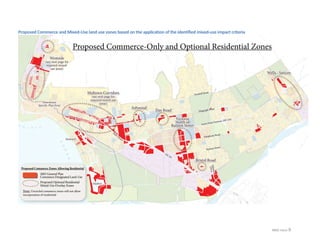
- 9. MXD Intro-8 Mixed-Use Designation Criteria Overview1. The International Council of Shopping Centers (ICSC) provides the following definition of mixed- use: A mixed-use development is a real estate project with planned integration of some combination of retail, office, residential, hotel, recreation or other functions. It is pedestrian-oriented and contains elements of a live-work-play environment. It maximizes space usage, has amenities and architectural expression, and tends to mitigate traffic and sprawl. 2. Staff-assessed potential mixed-use impacts Potential opportunities and constraints were used to evaluate compatibility of mixed-use. These were established based on the commerce and urban center classification systems, supportable household characteristics, aspects of mixed-use development in the definition above, local character, and possible finance implications. Simultaneously, based on these characteristics, mixed-use is envisioned as a contributor to a pedestrian-oriented area. Mixed-use impacts can be assessed as: Mixed-Use Potential Opportunities • Increase of supportable households in proximity to a commerce center (sustain and enhance local businesses and economic growth) • Provision of proximal housing for office, retail, and commerce employees thus decreasing commute time (lessen air quality impacts, improve the job/housing balance) • Increase in walkability around the commerce designated area and a pedestrian-oriented environment with walkable destinations to a larger number of residents and workers (healthy community, reduce auto dependency, and reduce air quality impacts) Mixed-Use Potential Constraints • May alter the character of existing single family neighborhoods (careful selection of sites, decide % of residential, and reliance on design review) • Implications for more City funds for capital improvements such as sidewalks, intersections, bicycle lanes, and walkable-friendly roadway improvements (updating development impact fees to better tailor to these types of improvements may be desirable) Application of the above opportunities and constraints criteria on Commerce areas served the Adhoc Committee and Staff in their preliminary identification of compatible Commerce and Mixed-Use land use zones throughout the City. The following map displays the summary of the proposed Commerce and Mixed-Use zones:
- 10. MXD Intro-9 Proposed Commerce and Mixed-Use land use zones based on the application of the identified mixed-use impact criteria
- 11. MXD Intro-10
- 12. MXD Intro-11 General Plan Refinement Recommendations A. COMMERCE In order to apply the commerce and mixed-use recommendations, two new designations would succeed the current Commerce designation in the General Plan: • A new General Plan Commerce designation that does not permit residential and replaces most of existing Commerce designations. The underlying existing zoning will remain the same but the residential use option will be removed from C-1, C-1A, C-2 zones. The new General Plan Commerce land use designation will permit mixed-use residential only under a new mixed-use overlay zone in the zoning code. This mixed-use overlay zone will allow residential in specified Commerce-designated areas. • A new General Plan Mixed-Use designation that allows mix of commerce and residential. The proposed Mixed-Use Designations coincide with the existing Midtown Corridors Development Code specified required mixed-use designations. The goal of the Mixed-Use Designation is to ensure a close connection between mixed-use and a pedestrian-oriented area instead of scattering mixed use throughout the City. Where deemed appropriate, the existing MXD zones, in the 4 instances where they occur, will either remain part of the existing specific plan (i.e. Saticoy-Wells), or staff will study options to implement in the zoning ordinance. Specifically, the recommended text changes are: New Commerce Designation1. Definition (underlined text is the proposed): Commerce – (T4 General Urban through T6 Urban Core, neighborhood center downtown, regional center, town center or village center) encourages a wide range of building types of anywhere from two to six stories (depending on neighborhood characteristics) that house a mix of functions, including commercial, entertainment, office, and limited housing in zoning code-specified areas. Commerce Designation with Limited Housing Option: These parts of commerce areas will be controlled by the mixed-use overlay zone specified in the Zones section below.
- 13. MXD Intro-12 Definition: Mixed-use designates an area that integrates a mix of compatible commercial and residential uses and creates a pedestrian oriented urban environment through a mix of residential density, specified design standards, and compatible commercial and/or professional uses. Where specified, the residential component is designed as either vertical (upper floors on a ground floor commercial space) or horizontal (typically the rear portion of the site). The overall design of a mixed-use development should create an integrated, complementary urban environment and feel. B. INDUSTRY Proposed changes in the Industry land-use definition in the General Plan (crossed-out text marks words for removal): Industry – (T2 Rural through T6 Urban Core) encourages intensive manufacturing, processing, warehousing and similar uses, as well as light, clean industries and support offices; also encourages workplace-serving retail functions and work-live residences where such secondary functions would complement and be compatible with industrial uses. Primarily large-scale buildings. Also can be developed as Transit Oriented Development, employment center or working village with a mix of uses. C. PUBLIC AND INSTITUTIONAL Proposed changes in the Public and Institutional definition in the General Plan (crossed-out text marks words for removal): Public and Institutional -- accommodates civic functions such as government offices, hospitals, libraries, schools and public green space. With changing demographics for an aging population it is important for the community to keep convalescent hospitals and rest home uses. By adjusting the designation definition, it broadens the institutional uses to not just public. This provides adjustments for convalescent homes to be consistent with the land use designation. Zone Ordinance Recommendations General Plan land use designations are implemented by zoning ordinances. The Zoning Code can address the General Plan designations that allow residential with a new overlay zone or use of existing zone (or both): • A Mixed-Use Overlay Zone will specify areas to incorporate a possible residential component in Commerce-designated areas. • A Mixed-Use Zone will serve all Mixed-Use-designations. New Mixed-Use Designation2.
- 14. MXD Intro-13 The following are two definitions that would be inserted into the zoning ordinance (these are nearly identical texts differing only in the underlined phrases): Mixed-Use Overlay Zone1. Purpose Statement: The intent of this overlay is to allow for greater flexibility in the utilization of land within certain Commerce-designated areas in the City of Ventura, through allowance for optional single mixed- use buildings and multi-building mixed-use developments that are in compliance with the goals and visions of the General Plan. Single mixed-use buildings and multi-building mixed-use developments are intended to maintain an X amount of commercial use while incorporating a Y amount of residential use, allow for efficient use of land and public services, encourage pedestrian oriented development, human interaction, and sense of place; create safe, attractive and convenient environments; and increase development alternatives. Mixed-Use Zone2. Purpose Statement: The intent of this zone is to allow for greater flexibility in the utilization of land within the Mixed- Use designated areas in the City of Ventura, through allowance for mixed-use single buildings and multi-building mixed-use developments that are in compliance with the goals and visions of the General Plan. Single mixed-use buildings and multi-building mixed-use developments are intended to maintain an X amount of commercial use while incorporating a Y amount of residential use, allow for efficient use of land and public services, encourage pedestrian oriented development, human interaction, and sense of place; create safe, attractive and convenient environments; and increase development alternatives. Note: Where limited Commerce areas are proposed to allow for "optional residential," the zoning ordinance would be amended to define the amount (percentage) of residential to commercial use allowed. Only as a projection, the 2005 General Plan has assumed 25% commercial, typically as ground floor or frontage, and 75% residential, typically as stories above or to the rear of the property. These percentages were set based upon the analysis of General Plan: providing the increased residential use to serve the current and expanded retail and services sector of our local economy. Commerce and Industry footnotes from General Plan Table 3-1 - Potential Development Based on Carrying Capacity of Land Area, state that:
- 15. MXD Intro-14 1. Commerce residential unit capacity is for property within a Corridor, District or Neighborhood Center and assumes buildout to the maximum FAR and that 25% of floor area would be commercial (with remainder residential). 2. Industry residential unit capacity is for property within a Corridor, District, or Neighborhood Center and assumes buildout to the maximum FAR and that 75% of floor area would be industrial (with the remainder) residential. There are market forces at play as well however and although the 2005 General Plan provides assessments of future residential and commercial development growth (2005 General Plan Table 3.1 - Potential Development Based on Carrying Capacity of Land Area, Table 3.2 - Predicted Development Intensity & Pattern, and Figure 3-1 – Infill Areas), it recognizes the role of market forces in shaping future growth in the City: The actual distribution of future growth in the City may vary based on market forces and other factors. The districts, corridors, and neighborhood center areas, shown on Figure 3- 1 Infill Areas, could accommodate more development and/or a different mix of development than shown in Table 3-2. To demonstrate this, Table 3-1 shows the potential development based on the overall carrying capacity of the land. The General Plan Refinement included analysis of supportable households necessary for viable commercial areas, and in most cases affirmed the General Plan, that more residential units are needed to support the local economy. The Adhoc Committee requested the percentages be re- considered but didn't provide a recommendation, waiting for the City Council to direct the percentages sought. When the City Council considers the appropriate percentage, the Housing Element must be considered to ensure adequate sites remain to accommodate the RHNA. To give the City Council the flexibility to make percentage adjustments while still remaining compliant with the Housing Element, one option would be to allow for greater percentage of residential, even to 100%, only on those properties contained in the Housing Element identified land inventory site so long as the proposed project will provide the residential units per the assigned affordable income categories.
- 16. MXD Intro-15 Recommendations per Commerce - Designated Area
- 17. MXD Intro-16
- 18. MXD Intro-17 EAST SIDE (5 areas) COLLEGE/ POINSETTIA (4 areas) MIDTOWN/ SEAWARD (6 areas) VICTORIA/ MONTALVO (4 areas)
- 19. City of Ventura General Plan Refinement Part I Recommendations for the Distribution of Residential Uses in Commerce-Designated areas East Side Commerce – 5 Areas Commerce-designated areas and residential addresses in Ventura’s East Side. Each of the 5 areas identified below will be analyzed individually in the following pages. 3,815 Residential Addresses in Serra 2,681 Residential Addresses in Wells (includes Parklands, UC Hansen Specific Plan Areas and 10 County addresses) 2,445 Residential Addresses in Juanamaria SATICOY COMMERCE AREA TELEPHONE/ CACHUMA COMMERCE AREA KIMBALL/ TELEGRAPH COMMERCE AREA WELLS CORRIDOR COMMERCE AREA .5 miles.250 N 3,651 Residential Addresses in Saticoy (Includes 227 County Addresses) PETIT/ TELEPHONE COMMERCE AREA Wells Saticoy Serra Juanamaria Residential address count extent General Plan-designated Commerce area Wells General Plan Planning Community
- 20. MXD ES - 2 0.25-mile Pedestrian Range in East Side Commerce Areas 0.25 mile (5-minute walk) pedestrian range and housing unit count in east side Commerce areas General Plan-designated Commerce area SATICOY COMMERCE AREA (401 units within .25 miles) TELEPHONE/ CACHUMA COMMERCE AREA (573 units within .25 miles) KIMBALL/ TELEGRAPH COMMERCE AREA (506 units within .25 miles) WELLS CORRIDOR COMMERCE AREA (1,152 units within .25 miles) .5 miles.250 N Wells Saticoy Serra Juanamaria .25 mile distances from edges of Commerce areas and internal circulation PETIT/ TELEPHONE COMMERCE AREA (1,144 units within .25 miles) Wells General Plan Planning Community
- 21. MXD ES - 3 Wells Corridor Commerce Area Commerce-designated areas in Wells: Wells Corridor Commerce Area Current Commerce Size and Supportable Households The Wells Corridor Commerce-designated area includes about 50,000 sq.ft. of built space. Based on the City’s business license records the Commerce area includes a gas station, convenient store, restaurant, bank, and medical offices with an estimated 86 employees. At this size, the Commerce area is at the convenience center level requiring about 2,000 households to be supportable within a range of 1.5 miles. If it reaches the neighborhood center level with a grocery store as an anchor and other tenants, the commerce area will require about 6,000 to 8,000 households to be supportable within a range of 2 -3 miles. N .5 miles.250 WELLS CORRIDOR COMMERCE AREA Parklands Specific Plan: 499 units 2,681 Residential Addresses within the Wells community (includes Parklands & UC Hansen Specific Plan Areas and 10 County addresses) Residential Address Count Extent City Boundaries Wells Saticoy 1,725 Residential Addresses within Saticoy east of South Saticoy Avenue UC Hansen Specific Plan: 195 units including 32 worker/ farmer housing
- 22. MXD ES - 4 However, at a range of 2 miles around the Commerce area includes Wells, Saticoy, and Juanamaria combined with 8,582 households or 22,056 people at an estimated density of 2.57 Ventura persons per household. Within .25 miles or a 5 minute walk from the Commerce area edges there are 1,152 households, more than half needed to support the current Commerce area. Within the Wells community, the total address counts are 2,486. Wells and east Saticoy –east of Saticoy Avenue-- communities combined include 4,406 households which could not potentially support a neighborhood center with a supermarket. Such an option appears even less viable with the presence of the existing supermarket at the Telephone/Petit Commerce area within a distance of only 1.5 to 2 miles from east Saticoy households. A neighborhood center with a supermarket in the Wells Commerce area would require at least 2,000 additional supportable households in both Wells and east Saticoy to a total of 6,406 supportable households. 0.25 mile (5-minute walk) pedestrian range and housing unit count in Wells Commerce area
- 23. MXD ES - 5 Zoning along the Wells Corridor Commerce Area *Perhaps future annexation; City pre-zoned already as T5.4, Urban Center Zone Mixed-Use Potential Impact Staff Comments • A minimum of 2,000 additional households might be needed in Wells and east Saticoy (east of South Saticoy Avenue) to support a grocery store. Based on the current household numbers only small retail seems supportable. Mixed-use will increase the number of supportable households for the existing or future commercial components. • Additional mixed-use development could be beneficial to the senior citizens in the assisted living facilities and non-medical home care establishments at the west corner of Wells and Telegraph Roads by offering destination options within a walkable proximity thus improving quality of life. Parklands Specific Plan Mixed-Use Area Senior Housing and Care Recommended for Public and Institutional UC Hansen Specific Plan Area WELLS CORRIDOR COMMERCE AREA
- 24. MXD ES - 6 • Mixed use would likely not impact the aesthetic character of existing single family neighborhoods because the Commerce area is large enough --0.5 miles long-- and bound by SR 126/ Santa Paula Freeway, Wells Road, and Telegraph Road on three sides. Staff Recommendation A Mixed-use overlay is recommended for the Wells Commerce-designated area along with infrastructure improvements to address walkability. Wells Corridor Commerce Area WELLS CORRIDOR COMMERCE AREA Parklands Specific Plan Mixed-Use Area Senior Housing and Care
- 25. MXD ES - 7 HELI (HOUSING ELEMENT INVENTORY) SITES IN THE WELLS CORRIDOR COMMERCE AREA HELI designated areas in Wells Corridor Commerce Area 2016 HELI (Housing Element Inventory) NUMBER OF UNITS Number of parcels: 5 Total number of units: 186 (2016 status) Very Low & Low Units: 43 Moderate Units: 5 Above Moderate Units: 138 Notes: 1. 111 Very Low & Low Units were left out of 2 planned projects 2. Above Moderate Units include 111 planned new units in Site Nos. 3 and 5 currently in the planning process, and 27 potential units in Site Nos. 1 and 4 3. 111 Very Low & Low units remain unmet need 4. 2013 status of the 5 parcels: Total units: 181 Very Low & Low Units: 154 Moderate Units: 0 Above Moderate Units: 27 1. 2. 3. 4. 5.
- 26. MXD ES - 8 Telephone/Cachuma Commerce Area Telephone/Cachuma Commerce Area Current Commerce Size and Supportable Households The Telephone/Cachuma Commerce-designated area includes about 42,000 sq. ft. of built space with about 32 businesses and offices and approximately 76 employees. Businesses include hair stylists, liquor store, bookkeeping, pet grooming, cosmetologist, Italian fast food restaurant, certified massage therapist, bar, veterinary clinic, bicycle repairs/sales, auto wash, restaurant, beauty shop, laundromat, fraternal organization, retail store, animal hospital, bar cocktail lounge, Mexican restaurant, takeout pizza, optometrist, state farm insurance, and dentist. Based on the number and types of businesses, as well as the lack of a large anchor store, the center is at the convenience center level requiring a trade range of about 1.5 miles and about 2,000 supportable households. .5 miles.250 N 3,815 Residential Addresses in Serra 3,651 Residential Addresses in Saticoy (Includes 227 County Addresses) SCANDIA (TELEPHONE/ CACHUMA) COMMERCE AREA Residential Address Count Extent City Boundaries Saticoy Serra Juanamaria Wells
- 27. MXD ES - 9 Within .25 miles or a 5 minute walk from the Commerce area edges there are 573 households which is about one quarter of the supportable households. The number of households within 1.5 miles includes about 3,651 residential addresses in Saticoy and 3,815 residential addresses in Serra Planning Community, enough to support this center. Wells Planning Community with 2,486 residential addresses could be considered part of Scandia Center trade range due to the proximity of the South Saticoy Avenue overpass. Juanamaria Planning Community however is at a two mile distance on either side of the Commerce area and is considered beyond its trade range. 0.25 mile (5-minute walk) pedestrian range and housing unit count in the Telephone/Cachuma Commerce Area
- 28. MXD ES - 10 Zoning in proximity to the Telephone/Cachuma Commerce Area Mixed-Use Potential Impact Staff Comments • There are enough households in the area to support the Telephone/Cachuma Commerce area. • The small size of the center and lack of higher density zoning create a dependency on the automobile and make mixed-use less significant in creating a walkable environment. • The Commerce area is surrounded by single-family surrounding areas and mixed-use will likely impact the character of the area. Staff Recommendation TELEPHONE/CACHUMA (SCANDIA) COMMERCE- DESIGNATED AREA
- 29. MXD ES - 11 Mixed use is not recommended for the Telephone/Cachuma Commerce-designated area. HELI (HOUSING ELEMENT INVENTORY) SITES IN TELEPHONE/CACHUMA COMMERCE AREA HELI designated areas in Telephone/Cachuma Commerce Area 2013 HELI NUMBER OF UNITS (Unchanged status in 2015 HELI update) Parcel Number: 089-0-100-170 Total number of units: 10 Very Low & Low Units: 0 Moderate Units: 0 Above Moderate Units: 10 TELEPHONE/ CACHUMA SCANDIA (COMMERCE AREA) HELI Site