
Recommended
More Related Content
Similar to Detail exploration plan for bakhud project
Similar to Detail exploration plan for bakhud project (10)
Recently uploaded
Recently uploaded (20)
Detail exploration plan for bakhud project
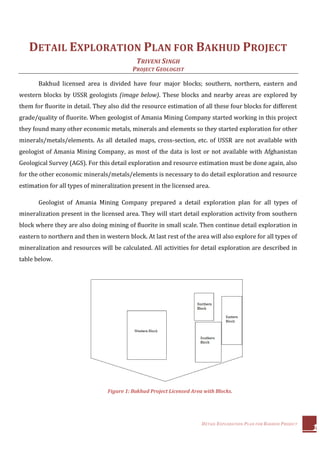
- 1. DETAIL EXPLORATION PLAN FOR BAKHUD PROJECT 1 DETAIL EXPLORATION PLAN FOR BAKHUD PROJECT TRIVENI SINGH PROJECT GEOLOGIST Bakhud licensed area is divided have four major blocks; southern, northern, eastern and western blocks by USSR geologists (image below). These blocks and nearby areas are explored by them for fluorite in detail. They also did the resource estimation of all these four blocks for different grade/quality of fluorite. When geologist of Amania Mining Company started working in this project they found many other economic metals, minerals and elements so they started exploration for other minerals/metals/elements. As all detailed maps, cross-section, etc. of USSR are not available with geologist of Amania Mining Company, as most of the data is lost or not available with Afghanistan Geological Survey (AGS). For this detail exploration and resource estimation must be done again, also for the other economic minerals/metals/elements is necessary to do detail exploration and resource estimation for all types of mineralization present in the licensed area. Geologist of Amania Mining Company prepared a detail exploration plan for all types of mineralization present in the licensed area. They will start detail exploration activity from southern block where they are also doing mining of fluorite in small scale. Then continue detail exploration in eastern to northern and then in western block. At last rest of the area will also explore for all types of mineralization and resources will be calculated. All activities for detail exploration are described in table below. Figure 1: Bakhud Project Licensed Area with Blocks.
- 2. DETAIL EXPLORATION PLAN FOR BAKHUD PROJECT 2 S. No. Activities Description Requirements Starting Date Duration 1 Detail sampling on grid (25 X 25 mts.) of southern block This detail sampling will be of soil and rock chips and with the results of these samples anomaly map will prepare for all types of mineralization. Team of 2 geologists with 2 labours and a 4x4 vehicle Second last week of August 2 - 3 months 2 Remote Sensing Study of big area from Landsat8 images. landsat8 Images (Already Purchased) Already Started 2 - 3 months 3 Drilling in southern block Drilling in southern block for resource estimation of all minerals and metals. As soon machines will arrive can start drilling. 2 - 3 drilling machines with its complete crew. Bentonite Clay. As soon new drilling machines will arrive Bakhud 4 - 5 months 4 Resource Estimation of southern block During drilling all the map and cross sections will prepared for all metals and mineral then with that all calculation for resource estimation will be done. Depends upon drilling 1 month 5 Stream Sampling of complete lisence area Detail sampling for searching the major source of all heavy metals/minerals/elements. This can be done after a month of remote sensing work and continue with other activities. Team of 2 geologists with 2 labours and a 4x4 vehicle After a month of remote sensing Depends upon the size of the marked area. 6 Detail sampling on grid (25 X 25 mts.) of eastern block and all adjoining areas This detail sampling will be of soil and rock chips and with the results of these samples anomaly map will prepare for all types of mineralization. Team of 2 geologists with 2 labours and a 4x4 vehicle second last month of drilling in southern block 5 - 6 months 7 Drilling in eastern block and adjoining areas Drilling in eastern block and adjoining areas for resource estimation of all minerals and metals. 2 - 3 drilling machines with its complete crew. Bentonite Clay. After complition drilling of southern block 10 - 12 months 8 Resource Estimation of eastern block and adjoining areas During drilling all the map and cross sections will prepared for all metals and mineral then with that all calculation for resource estimation will be done. Depends upon drilling 1 month 9 Detail sampling on grid (25 X 25 mts.) of nothern block and all adjoining areas This detail sampling will be of soil and rock chips and with the results of these samples anomaly map will prepare for all types of mineralization. Team of 2 geologists with 2 labours and a 4x4 vehicle second last month of drilling in eastern block 5 - 6 months 10 Drilling in nothern block and adjoining areas Drilling in nothern block and adjoining areas for resource estimation of all minerals and metals. 2 - 3 drilling machines with its complete crew. Bentonite Clay. After complition drilling of eastern block 8 - 10 months 11 Resource Estimation of nothern block and adjoining areas During drilling all the map and cross sections will prepared for all metals and mineral then with that all calculation for resource estimation will be done. Depends upon drilling 1 month 12 Detail sampling on grid (25 X 25 mts.) of western block and all adjoining areas This detail sampling will be of soil and rock chips and with the results of these samples anomaly map will prepare for all types of mineralization. Team of 2 geologists with 2 labours and a 4x4 vehicle second last month of drilling in nothern block 10 - 12 months 13 Drilling in western block and adjoining areas Drilling in western block and adjoining areas for resource estimation of all minerals and metals. 2 - 3 drilling machines with its complete crew. Bentonite Clay. After complition drilling of northern block 13 - 15 months 14 Resource Estimation of western block and adjoining areas During drilling all the map and cross sections will prepared for all metals and mineral then with that all calculation for resource estimation will be done. Depends upon drilling 1 month 15 Detail sampling on grid (25 X 25 mts.) in rest of the licensed area Area for sampling will be marked on the basis of remote sensing analysis and stream sampling resuslts Team of 2 geologists with 2 labours and a 4x4 vehicle second last month of drilling in western block Depends upon the size of the marked area. 16 Drilling in rest of the licensed area. Drilling in the rest of the area for resource estimation of all minerals and metals. 2 - 3 drilling machines with its complete crew. Bentonite Clay. Depends upon sampling results in the area. Depends upon sampling results in the area. 17 Resource Estimation of all metals and minerals in rest of the area. During drilling all the map and cross sections will prepared for all metals and mineral then with that all calculation for resource estimation will be done. Depends upon drilling Depends upon sampling results in the area.
- 3. DETAIL EXPLORATION PLAN FOR BAKHUD PROJECT 3 All activities for detail exploration are completely depends upon the availability of the required things. Following are some important things which can make delay to start or in progress of detail exploration: Availability of 4X4 Vehicle: For detail sampling it is must that one 4X4 vehicle always available for team of 2 geologists and goes with them while sampling. Availability of Labors: During detail sampling at least 2 labors are required who can do digging for sample and carry them while traversing. Availability of water: For drilling water is must, so it is extremely important to have a proper supply of water to all drilling machines. Drilling is not possible without water so if it is not available of have any issues then drilling may stops. In the rock formation there is several location which are highly fractured, so those places have water loss. These places with fractures can fix with cement but not always. So we must keep this in mind the water consumption is not always same and may increase a lot. Availability of Drilling machines: At present there is only one drilling machine is available which is not capable to drill more 3 – 4 meters and maximum 20 – 30 meters in a month. It is in plan to purchase 2 new drill machines, so it is important that those machines must be available at site soon. These machines must be capable to drill minimum 10 – 20 meters in a day otherwise the complete drilling program will delayed because of their slow progress and other activities will also delayed, as one activity depends upon other activity in detail exploration. Availability of drilling crew: Drilling crew must have good experience in drilling and recording all data while drilling. In drilling crew there are two most important persons who are driller and logger. Both of these works can be done by one person also but that person must be having good experience in this. These persons must be educated so they can easily make all records while drilling and can understand things easily. If this crew is not available on time even drilling machine are available it is not possible to drill and it is also must to have some more skilled persons than machines as when one will go on vacation other can take his place and continue drilling. All these above requirements are must for detail exploration work for complete license area of Bakhud Project.
- 4. DETAIL EXPLORATION PLAN FOR BAKHUD PROJECT 4 For boosting all detail exploration activities so exploration can be completed soon the only way is to increases the available resources; number of junior geologist, drilling machines and other technicians. Following are the most important things for completing detail exploration and get the complete resources soon: More Number of Junior Geologists: For completing all detail exploration activities it is most important to collect all types of geological data as soon as possible. This is only possible when number of junior geologist will increase. With more junior geologist data collection (grid sampling, drill core logging, etc.) will be fast and all data can be collected in less time. For data processing and interpretation two senior geologists are enough. More Drilling Machines: For resource estimation drilling is must, so number of drilling machines can be increased to do resource estimation of all present metals, minerals and elements in less time. When more drilling machines will work more data can be generated in less time and can be processed for resource estimation of all present metals, minerals and elements. CONCLUSION AND DISCUSSION Detail exploration is must in Bakhud Project as it was first explored only for fluorite not for other precious and base metals. All these metals and minerals are much expensive and can give more revenue than fluorite. So everything must be systematically explored for exploitation and for not losing anything economical. As the rock formations have some clay stones which are very soft and limestone which is highly fractures. Because of these two reasons there are always some issues in drilling machine; clay stone becomes clay and washed with water, so with this much core is lost and with high fractures high loss of water. With core loss it is impossible to get any data and as these clay stones have high alteration and in eastern-block have very good mineralization, so losing that core means we can’t get information of that mineralized zones. Both of these issues can be solved with ‘Bentonite Clay’. From this core recovery will increase and water consumption will decrease. So it is highly recommended to use this bentonite clay for drilling.