
Recommended
More Related Content
Similar to Basics and ga geography
Similar to Basics and ga geography (20)
Recently uploaded
Recently uploaded (20)
Basics and ga geography
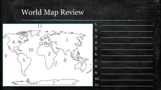
- 1. World Map Review 1. ______________________ 2. ______________________ 3. ______________________ 4. ______________________ 5. ______________________ 6. ______________________ 7. ______________________ 8. ______________________ 9. ______________________ 10. ______________________ 11. ______________________
- 2. The Southeast g f h e c a b d i j a. ______________________ b. ______________________ c. ______________________ d. ______________________ e. ______________________ f. ______________________ g. ______________________ h. ______________________ i. ______________________ j. ______________________ k. ______________________ k
- 3. Hemispheres ▪ Hemi- half ▪ Sphere- solid circular figure
- 4. Continents
- 5. Nation
- 6. Region
- 7. Georgia's Location Georgia is located in which two hemispheres? Georgia is located on what continent? Georgia is located in which nation? Georgia is located in which region of the United States?
- 9. Five Physical Regions of Georgia ▪ 1: Blue Ridge ▪ 2: Ridge andValley ▪ 3: Appalachian Plateau ▪ 4: Piedmont ▪ 5: Coastal Plain
- 10. Physical Map of Georgia a b c d e f g • A: Fall Line • B: Barrier Islands • C: Okefenokee Swamp • D: Appalachian Mts. • E: Blue Ridge Mts. • F: Savannah River • G: Chattahoochee River
- 11. In which region would you find these landforms?
- 12. Appalachian Plateau ▪ Location – Farthest NW corner of GA ▪ Climate – Mild summers; cooler winters due to higher elevation; some snow and ice in winter ▪ Resources/Agriculture – Not good for farming – Some corn and soybeans grown here ▪ Features & Facts – Smallest region – Lookout Mountain & Cloudland Canyon – Caving is popular ▪ Economics – Most profitable industries are tourism and forestry – Coal, iron ore, and limestone mined here
- 13. In which region would you find these landforms?
- 14. Coastal Plains ▪ Location? – Southern half of the state; largest region – Stretches from east to west state boundaries ▪ Climate? – Humid and subtropical – Long, hot summers and mild winters ▪ Resources/Agriculture – Fertile soil; most of state’s crops – Peanuts, Vidalia onions, pecans, soybeans, cotton – tourism ▪ Features & Facts – Barrier islands & Okefenokee swamp – Inner Plains (farmland) & Outer Plains (coast & swampland) ▪ Economics – Pulp & paper industry – Commercial fishing – Tourism near barrier islands – Deepwater ports
- 15. In which region would you find these landforms?
- 16. Blue Ridge ▪ Location – Northeast corner – Southern Appalachian Mts. ▪ Climate – Most rainfall. Savannah and Chattahoochee rivers originate here – Cooler due to higher elevation ▪ Resources/Agriculture – Small farms in valleys produce apples, corn, other vegetables – Pastures home to large animals ▪ Features & Facts – Brasstown Bald, Georgia’s highest peak – Beginning of the Appalachian trail – Dahlonega; 1st gold rush town ▪ Economics – Harvesting timber – Historically: mining gold
- 17. In which region would you find these landforms?
- 18. Piedmont ▪ Location – North of Coastal Plains – Stretches from east to west state boundaries ▪ Climate – Hot summers, mild winters – Some snow possibility ▪ Resources/Agriculture – A lot of agricultural production; cotton, soy, wheat, poultry/eggs, hogs, cattle/beef, peaches (along Fall Line) ▪ Features & Facts – Gently rolling hills; “foot of the hills” – Red clay – Urban cities of Atlanta, Columbus, Augusta, and Macon. Most populous region. – Stone Mountain ▪ Economics – A lot of manufacturing and large scale farming – National & international businesses
- 19. In which region would you find these landforms?
- 20. Ridge and Valley ▪ Location – Northwest GA; east of Appalachian Plateau ▪ Climate – Similar to Appalachian Plateau ▪ Resources/Agriculture – 4% of valley is used as pasture & farmland – Corn, soybeans, wheat, cotton – Pine timber ▪ Features & Facts – Dalton, the carpet capital of the world – Numerous caves ▪ Economics – Textile & carpets – Some mining
- 21. Quick Review ▪ Smallest? – Appalachian Plateau ▪ Largest? – Coastal Plains ▪ Most Populated? – Piedmont ▪ Carpets? – Ridge and Valley ▪ Gold? – Blue Ridge ▪ Most rainfall? – Blue Ridge • Peaches? • Piedmont & Coastal Plains (mostly along Fall Line) • Peanuts? • Coastal Plains • Swamp? • Coastal Plains • Brasstown Bald? • Blue Ridge • Lookout Mountain? • Appalachian Plateau ▪ Mining? – Appalachian Plateau (and a little Valley & Ridge) ▪ Cattle & Poultry? – Piedmont
- 22. Think About It ▪ Savannah was one of Georgia’s first permanent settlements. Why do you think colonists chose this location back in the 1700s?
- 23. Savannah River ▪ Forms the eastern border between Georgia and South Carolina ▪ Historically – Explored by De Soto – Good settlement location for natives and first Georgians ▪ Today: – Shipping – Cooling nuclear power plants – Hydroelectric power – Drinking water
- 24. Chattahoochee River ▪ Partially forms Georgia’s western border with Alabama ▪ Historically use for… – Transportation for Native Americans – Too difficult to use for transportation today ▪ Currently used for… – industry, drinking water (especially for ATL), and recreation
- 25. Barrier Islands ▪ A 100 mile line of islands. ▪ Called barrier islands because they block beaches from wind, sand, and water erosion. ▪ Nationally protected parks and seashores ▪ Historically used for missions, forts, and plantations.
- 26. Okefenokee Swamp ▪ Largest freshwater swamp in North America (700 square miles) ▪ War between colonists and natives fought here ▪ Used to be a source of timber, until FDR turned the swamp into a wildlife refuge area.
- 27. The Fall Line ▪ Natural boundary between the Coastal Plain and Piedmont regions ▪ Significant drop in elevation from north to south, creating a line of waterfalls – Because it was the end of navigable waters for early settlers, many explorers set up forts & towns along the Fall Line ▪ Used to be the location of the Atlantic coast in the Mesozoic era ▪ Used for mills and hydroelectric power
- 28. Appalachian Mountains ▪ Found in northern regions of the state ▪ Rounded and weathered, after millions of years of erosion ▪ Brasstown Bald – highest peak in the state – found in Blue Ridge region ▪ Gold found near Dahlonega in 1828 began the state’s gold rush
- 29. What are the different ways Georgia utilizes TRANSPORTAITON?
- 30. Georgia's Transportation Systems ▪ Economic impact – Local impact: provide job opportunities – Helps the development of cities – Brings tourists to the state – Domestic and international trade (exports and imports)
- 31. How did water affect Georgia’s development?
- 32. Historical Importance of Water ▪ Chattahoochee, Savannah, and St. Mary’s rivers create natural boundaries for Georgia ▪ Natives & early settlers used rivers for food and transportation ▪ Water used for rice and cotton farming ▪ Ports of Savannah & Brunswick used for trade ▪ Rivers transported goods & people as settlers expanded into native lands
- 33. Georgia’s Climate ▪ Mostly mild/moderate, with subtropical temperatures near the coast. ▪ 4 distinct seasons ▪ Mild climate=major companies, longer growing seasons, natural irrigation ▪ Vertical climate: the temperature drops as the elevation rises ▪ Precipitation: – Snow melts and runs off into streams and lakes – Avg. 42-50 inches of rain per year
- 34. Multiple Choice Review ▪ Why is the population of Georgia heavily concentrated in the Atlanta area? A) Atlanta has a larger geographic area than other cities. B) Agricultural areas are more productive than urban areas. C) Other parts of the state have tried to maintain their historic populations. D) The airport and highway systems make Atlanta a major transportation hub.
- 35. Multiple Choice Review ▪ Which terms best describes the Piedmont region of Georgia today? A) broad treeless plains, richest soil in Georgia B) heavily forested, highest elevation in Georgia C) gently sloping land, lowest elevation in Georgia D) rolling farmland, most heavily populated region of Georgia
- 36. Multiple Choice Review ▪ Which best describes the fall line in Georgia? A) the nickname of Georgia's border with Florida B) the natural border between the Piedmont and the mountains C) a man-made boundary dividing the Piedmont from the coastal plain D) a zone several miles wide that marks the prehistoric ocean's shoreline
- 37. Multiple Choice Review Which list gives the correct location of Georgia? A. Northeastern United States, North America, Northern Hemisphere B. MidAtlantic United States, North America, Southern Hemisphere C. Southeastern United States, North America, Eastern Hemisphere D. Southeastern United States, North American, Western Hemisphere
- 38. Multiple Choice Review ▪ Because of the climate in Georgia, early colonists found Georgia to be a good place for ▪ A) the king to reside. ▪ B) the first American colony. ▪ C) growing crops to send to England. ▪ D) hiring people to work in England.
- 39. Multiple Choice Review ▪ What is the importance of the Okefenokee Swamp to Georgia? ▪ A) It once served as a buffer zone between the United States and the French Empire. ▪ B) It was the site of the first settlement of Native American Indians in the state of Georgia. ▪ C) It contains miles of inland waterways used to link parts of the state together for transportation of goods produced in Georgia. ▪ D) It provides habitats for endangered and threatened species such as the red-cockaded woodpecker and a wide variety of other wildlife species.
- 40. Multiple Choice Review ▪ Beginning in the 1990s, Georgia, Alabama, and Florida, entered into a legal battle involving the environment. Each state was claiming ownership of a natural resource. ▪ Which of these would MOST likely be the source of this legal battle? ▪ A) Savannah River ▪ B) Barrier Islands ▪ C) Okefenokee Swamp ▪ D) Chattahoochee River
- 41. Multiple Choice Review ▪ Which of the following describes similarities between regions 1, 2, 3, and 5? ▪ A. They are relatively flat. ▪ B. The have sparse populations. ▪ C. They are mostly mountainous. ▪ D. They are the oldest geographic regions.