SlideShare a Scribd company logo
1 of 7
Download to read offline
IESO 2014 – Study Case A. The Geological Journey of Charles Darwin – pg. 1
Charles Darwin was a modern naturalist with a passion for Geology, even if most people would think of him as a
biologist. He believed in the words of Alexander von Humboldt: “It is by isolating facts that travellers (…) have given
birth to so many false ideas (…). The great geological phenomena are subject to the same laws, as well as the forms
of plants and animals”. He studied with some of the first scientific geologists, like John Stevens Henslow, Adam
Sedwick (the Geology Museum of Cambridge University is devoted to this man that took Darwin to his fieldtrips)
and Charles Lyell (who insisted upon Darwin the importance and urgency of publishing his Origin of Species). In
fact, the only paid job in Darwin’s life was the position of Secretary of the Geological Society of London.
The offer of Captain Fitzroy to travel with him, onboard HMS Beagle, gave Darwin an opportunity to explore the
Earth. When Darwin chose a little bunch of books for his luggage, he took Lyell’s Principles of Geology where he read:
“A sketch of the progress of Geology is the history of a constant and violent struggle between new opinions and
ancient doctrines…” When the Beagle set sail from Davenport on 27 December 1831, he wanted to play a role on
this history. Moreover, when he arrived to Falmouth 2 October 1836, almost five years later, he had done even more:
his contributions to Geology, being important, where to be shadowed by his contributions to Biology.
During the Beagle expedition, Darwin made many important geological observations and interpretations –some still
accepted. However, he also passed across geological phenomena impossible to understand with the knowledge and
tools of the day. Therefore, following Charles Darwin and the Beagle is still a trip of geological exploration.
Figure1.Voyage of the Beagle. Key : 1 Plymouth - 2 Tenerife - 3 Cape Verde - 4 Bahia - 5 Rio de Janeiro - 6 Montevideo - 7 Falkland
Islands - 8 Valparaiso - 9 Callao / Lima - 10 Galapagos - 11 Tahiti - 12 New Zealand - 13 Sydney - 14 Hobart - 15 King Sound –
16 Cocos (Keeling) Islands - 17 Mauritius - 18 Cape Town - 19 Bahia - 20 Azores
Paper 1
The Geological Journey of
Charles Darwin
IESO 2014 – Study Case A. The Geological Journey of Charles Darwin – pg. 2
1. The Beagle main target was mapping. To take precise measures it carries some 28 precision chronographs
(the best then manufactured). Watches (= pengukur waktu/jam) were essential (and still are useful) to
measure…
a) Navigation distance
b) Geographic Latitude
c) Geographic Longitude
d) Tide amplitude
e) Coastal drift
f) Sea Altitude
g) Relative Humidity
h) Atmospheric pressure
2. Mark ALL the tectonic plates that the Beagle crossed in its route…
a) African
b) Antarctic
c) Arabian
d) Atlantic
e) Australian
f) Cocos
g) Eurasian
h) Indian
i) Nazca
j) North-American
k) Pacific
l) South-American
3. Between the voyages of Christopher Columbus (1492-1493) and Charles Darwin (1831-1832) had passed
some 350 years. Assuming that tectonic activity (pergerakan lempeng) has remained constant, Darwin found
an Atlantic Ocean approximately…
a) 300 m wider
b) 100 m wider
c) 10 m wider
d) Equal in width
e) 10 m narrower
f) 100 m narrower
g) 300 m narrower
h) Impossible to know even today
Modern ocean navigation gets
important information from
meteorological agencies and
models. For instance, many
institutions, using different
physical and mathematical
models, predict the trajectory of
hurricanes. A common way to
ensemble the diversity of
predictions is a Spaghetti Plot
(figure 2). Each individual
forecasts is represented by one
line, and merged into one image.
4. The purpose of a spaghetti plot is
to give the user some idea of the…
a) Width of the hurricane
b) Reliability of the prediction
c) Straightness of trajectories
d) Time of arrival of hurricanes
e) Area affected by hurricane
5. Which of the three areas
marked (ditandai dengan huruf besar)
in figure 2 provides the shortest
term prediction within this
diagram
a) A
b) B
c) C
d) None
A
B
C
Figure2. Spaghetti plot for tropical storm Irene, August 2011
IESO 2014 – Study Case A. The Geological Journey of Charles Darwin – pg. 3
After a visit to Cape Verde Islands, the Beagle
sailed across the Atlantic Ocean and that included
the visit to St. Paul’s Rocks (figure 3). St.Paul’s
Rocks (Brazil) is uninhabited set or rocky islets in
the Atlantic Ocean, very close to the equator
(00º55' N 29º20). The Beagle docked on the islets
on 16 February 1832 and Darwin set to explore a
place that was to challenge his geological
knowledge. Darwin wrote “Is not this the first
Island in the Atlantic which has been shown not
to be of volcanic origin?” and “unlike anything
which I have met with”. Late in 20th century the
samples that Darwin had taken in the spot where
identified as “mylonited amphibole-rich
peridotites”. Mylonites were defined in the 1880s,
peridotites in the 1840s and plate tectonics did not
arrive until the 20th century. Hence, we can feel like the astonished Darwin.
6. According with General Atmosphere Circulation models, which wind direction should dominate in St. Pauls
Rocks?
a) Northward
b) Eastward
c) Southward
d) Westward
7. Given the composition of a peridotite, an igneous rock rich in olivine, and given the setting of St. Paul’s Rocks,
the most likely origin of them must be a fragment of…
a) South-America or Africa continental lithosphere, trapped during the first phases of splitting.
b) Some old subduction zone in the Atlantic coast, when the ocean was narrower.
c) Mantle brought to the surface during the splitting of Africa and America.
d) The Earth’s outer core brought to the surface by deep convection.
8. Mylonites are metamorphic rocks produced by friction and pressure. These rocks can be related to…
a) Ocean ridge volcanism
b) Transform fault movement
c) Subduction friction
d) A triple point between three plates
On 22 August 1832, the Beagle was sailing from Montevideo to Bahia, North of Cape St Antonio (approx. 36º S 56º
W).
9. Given the Earth radius is 6371 km and the sky was very similar to present, how far should the Beagle travel
to see both  Ursae Polaris (the Northern Star) and  Octantis (very close to the Southern Cross)?
a) 6371 km northwards
b) 4000 km northwards
c) 2000 km northwards
d) 6371 km westwards
e) 4000 km eastwards
f) 2000 km southwards
g) 4000 km southwards
h) 6371 km southwards
The Beagle arrived in Buenos Aires (Argentina) 311 days after its departure from Britain, on 2 Nov 1832. Until
January 1833, Darwin had countless occasions to explore the Atlantic Argentina coast, the Pampa and the Patagonian
regions. This rather flat area, covered by loess, hides a complex geologic history and structure. Study the following
idealized profile and answer the following questions (figure 4).
Cape Verde
St Paul Rocks, Brazil
Fernando de Norohna,
Brazil
Figure 3. The route of the Beagle across the Atlantic Ocean, with
indication of the islands that Darwin could explore.
Salvador de Bahia,
Brazil
IESO 2014 – Study Case A. The Geological Journey of Charles Darwin – pg. 4
10. Loess is a deposit that covers huge extensions of Patagonia. The thin dust is transported by the wind but it’s
produced from…
a) Settled volcanic ashes
b) Alluvial flooded plains
c) Glacial dust
d) Coastal plain dunes
11. The present concentration of a hypothetic radioactive isotope (xxGx) related to original concentration has been
measured in geological units 2, 8 and 9. The half-life (t½) of xxGx is 50 million years. The geological unit 2 was
formed… ago (1 Ma = 1 million years).
a) 10 Ma
b) 30 Ma
c) 50 Ma
d) 70 Ma
e) 90 Ma
f) 110 Ma
12. The origin of geological unit 2 is necessarily related to…
a) A sedimentary process
b) An intrusive process
c) A faulting process
d) A volcanic process
e) An edaphic process
f) A glacial process
g) An orthomagmatic dike
h) A plutonic process
13. Which of the three disconformities shown in Figure 4 could be an angular discordance?
a) A
b) B
c) C
d) None
Figure 4. LEFT: Schematic section of the geological units in a region of the Atlantic Coast of South America. Key: 1. Loess. 2. Igneous
rock with concentration of [xxGx]=70% of original. 3. Sandstone with rodents teeth and contact metamorphism on top.4. Nummulithic
Limestone. 5. Late Mesozoic Clay with Ammonites. 6. Limestone. 7. Folded Schist. 8. Granite ([xxGx]=4.42% of original). 9. Aplite
([xxGx]=6.25% of original). A, B and C. Disconformities. RIGHT: Blank disintegration diagram for isotope xxGx .
6
7
8
1
2
3
4
5
9
A
B
C
0 50 100 150 200 250
Time in millions of years (Ma)
ParentAtoms%
IESO 2014 – Study Case A. The Geological Journey of Charles Darwin – pg. 5
14. Which of the following pairs of units in Figure 4 show evidence of a marine regression? (Mark all the right
answers)
a) 9>8
b) 8>7
c) 7>6
d) 6>5
e) 5>4
f) 4>3
g) 3>2
h) 2>1
i) None
15. Referring to Figure 4, which of the following is closest to the age of the folding of unit 7? (You will need to
plot the graph)( Anda harus membuat grafik peluruhan atomnya terlebih dahulu )
a) 125-150 Ma
b) 150-175 Ma
c) 175-200 Ma
d) 200-225 Ma
e) 225-250 Ma
After exploring the Atlantic coast of South-America, the Beagle paid a second visit to Tierra del Fuego and sailed
toward the Pacific Ocean, across the Beagle Channel.
16. In this area, Darwin could have experienced the Antarctic Circumpolar Current (ACC) but could not suspect the
existence of the Antarctic Bottom Waters (AABW). Which of the following is most correct?
a. ACC is a valuable wind for sailing and AABW is dangerous due to the presence of icebergs
b. ACC was active in the times of Darwin and AABW is a recent current due to climate warming and Antarctic
ice melting.
c. ACC is very saline and AABW has a very low salinity
d. ACC is a wind driven current and AABW is a density driven current
17. The Beagle channel is a valley excavated by Pleistocene glaciers and consequently it can be described as…( Selat
Beagle pada awalnya adalah lembah yang terbentuk akibat gerusan glasier pada zaman Pleistocene dan karena itu dapat
digambarkan sebagai ….)
a. A glacial eroded horn
b. A fjord inundated by sea level rise
c. A periglacial environment
d. A fluvial invasion of glacial crevasses
e. An isostatic subsidence valley
On 20th February 1835 the Beagle was in Valdivia when an earthquake hit the region. Darwin wrote in his journal:
“This day has been remarkable in the annals of Valdivia for the most severe earthquake which the oldest inhabitants
remember”. By 5th March, he landed in Concepcion (Chile) 36º52' S 73º01' W and found "That not a house in
Concepcion or Talcuhano (the port) was standing, that seventy villages were destroyed, and that a great wave had
almost washed away the ruins of Talcuhano".
18. Given the three seismograms and the provided map, choose the location of the epicentre.
[Choose a, b, c ,d or e in your answer sheet]
S2
S3
S1
a
d
b
c
e
Figure5.A. Map of a region of Chile, with the Pacific Ocean to the West and the Andes to the East. S1, S2 and S3 are three seismic stations.
The points a-e show possible epicenters of an earthquake. B. Seismograms registered in stations S1-S3, with indication of the arrival times of
P and S waves (in seconds).
IESO 2014 – Study Case A. The Geological Journey of Charles Darwin – pg. 6
Along the journey, the Beagle visited many kilometres of coast. Look at figure 6 to answer questions 19 and 20:
19. Which drawing is the best representation of the Atlantic coast of Santa Fe (Argentina)?
[Choose a, b, c or d in your answer sheet]
20. Which drawing is the best representation of the Pacific coast of Concepción (Chile)?
[Choose a, b, c or d in your answer sheet]
Galapagos Islands are a milestone for Darwin and any later
biologist. From an Earth Science point of view, they also
represent a rather special setting. The geological setting in
Galápagos is similar to Hawaii
21. Which of the following statements best describe the
Galápagos Geological setting?
a) They are on a Benioff plane
b) They are on a mantle plume
c) They are on a lithosphere isostasy rift
d) They are on one transform fault
22. The volcanism of Galapagos Islands is…
a) Of the same age in all the islands
b) Of random age in the archipelago
c) Older in the west
d) Younger in the west
e) Older in the east
f) Younger in the east
By the time the Beagle arrived in the Cocos-Keeling Islands, Darwin had observed a lot of evidence of uplifting
processes (seashells in mountains, volcanic islands, etc.) and he felt there must be evidence of subsidence somewhere
to guarantee some Earth equilibrium. In fact, The Structure and Distribution of Coral Reefs was published in 1842 as the
first part of the geology of the voyage of the Beagle. In his map of coral reefs he identified two main types of reefs:
“Red for active volcanoes and blue for fringing reefs”. In the Cocos-Keeling Islands, Fitzroy probed the reef and
produced a precise chart that remained the standard until World War II.
This precise survey and his observations allowed Darwin to develop an explanation of reef and atoll formation that
is still accepted.
Figure 6. Four simplified hypothetic types of coast profiles.
Figure 7. Simplified tectonic setting of Galapagos Islands.
Arrows show plate movement.
IESO 2014 – Study Case A. The Geological Journey of Charles Darwin – pg. 7
23. The red reefs (enclosed with dotted lines) of Darwin’s map are essentially related to
a) Subduction zones
b) Dorsal zones
c) Hot spots
d) Transforming faults
e) Continental lithosphere
24. The atolls are formed in…
a) Extinct volcanoes uplifted due to mantle plumes push
b) The crater of active volcanoes, producing atoll ring of corals
c) The slopes of extinct, subsiding volcanoes, with the corals growing to reach sun light
d) Active volcanoes of low temperature
e) Active explosive volcanoes
Along the trip, Darwin didn’t pay much attention to stars, but it’s sure
that Fitzroy did. On Sunday, 21 Aug 1836, the Beagle crossed the
Equator in his return trip to England. Along the trip, they could very
often observe the constellations of the celestial equator, such as
Orion. Among the stars of Orion, some are rather prominent stars, as
Betelgeuse and Rigel.
25. Identify Betelgeuse in the map.
[Choose a letter from A to H in your answer sheet]
26. Identify Rigel in the map.
[Choose a letter from A to H in your answer sheet]
Cocos – Keeling Islands
Figure 8. Darwin's map of coral reefs. Some of his "red" reefs, associated to active volcanoes, are enclosed with doted lines. Some of his "blue"
reefs, or fringe reefs, are enclosed with solid lines. Cocos-Keeling Islands are also marked.
Figure 9. Simplified stellar map of
constellation Orion

More Related Content

What's hot

Part 5 geology - gradulaism or catastrophism
Part 5   geology - gradulaism or catastrophismPart 5   geology - gradulaism or catastrophism
Part 5 geology - gradulaism or catastrophismdontmonkeywithgod
 
Budget of work of earth and life science
Budget of work of earth and life scienceBudget of work of earth and life science
Budget of work of earth and life scienceJohndy Ruloma
 
Venusian Habitable Climate Scenarios: Modeling Venus Through Time and Applica...
Venusian Habitable Climate Scenarios: Modeling Venus Through Time and Applica...Venusian Habitable Climate Scenarios: Modeling Venus Through Time and Applica...
Venusian Habitable Climate Scenarios: Modeling Venus Through Time and Applica...Sérgio Sacani
 
The geologic time scale
The geologic time scaleThe geologic time scale
The geologic time scaleShahid Hussain
 
Continent shapes outline
Continent shapes outlineContinent shapes outline
Continent shapes outlineLori Welsh
 
Introduction to Geomorphology
Introduction to GeomorphologyIntroduction to Geomorphology
Introduction to GeomorphologyShoaib Ahmed
 
Summative assessment 1 week 1 (final)
Summative assessment 1 week 1 (final)Summative assessment 1 week 1 (final)
Summative assessment 1 week 1 (final)MykelCaete
 
McClymont_Alastair-Publication_List
McClymont_Alastair-Publication_ListMcClymont_Alastair-Publication_List
McClymont_Alastair-Publication_ListAlastair McClymont
 
Oxford dictionary earth science
Oxford dictionary earth scienceOxford dictionary earth science
Oxford dictionary earth scienceWael Sharba
 
Geological time scale.
Geological time scale.Geological time scale.
Geological time scale.Awais Bakshy
 
Honors geo. ch 1 (p.p.) pt. 1
Honors geo. ch 1 (p.p.) pt. 1Honors geo. ch 1 (p.p.) pt. 1
Honors geo. ch 1 (p.p.) pt. 1tobin15
 
Plate tectonics the oceans part iiic no text
Plate tectonics the oceans part iiic no textPlate tectonics the oceans part iiic no text
Plate tectonics the oceans part iiic no textWilliam Szary
 
Class 11 Cbse Geography Syllabus 2012-13
Class 11 Cbse Geography Syllabus 2012-13Class 11 Cbse Geography Syllabus 2012-13
Class 11 Cbse Geography Syllabus 2012-13Sunaina Rawat
 
Class 11 Cbse Geography Syllabus 2011-12
Class 11 Cbse Geography Syllabus 2011-12Class 11 Cbse Geography Syllabus 2011-12
Class 11 Cbse Geography Syllabus 2011-12Sunaina Rawat
 

What's hot (20)

Part 5 geology - gradulaism or catastrophism
Part 5   geology - gradulaism or catastrophismPart 5   geology - gradulaism or catastrophism
Part 5 geology - gradulaism or catastrophism
 
Nasa
NasaNasa
Nasa
 
Budget of work of earth and life science
Budget of work of earth and life scienceBudget of work of earth and life science
Budget of work of earth and life science
 
ES_1976_BSc_Allen_Ralph_P (1)
ES_1976_BSc_Allen_Ralph_P (1)ES_1976_BSc_Allen_Ralph_P (1)
ES_1976_BSc_Allen_Ralph_P (1)
 
Venusian Habitable Climate Scenarios: Modeling Venus Through Time and Applica...
Venusian Habitable Climate Scenarios: Modeling Venus Through Time and Applica...Venusian Habitable Climate Scenarios: Modeling Venus Through Time and Applica...
Venusian Habitable Climate Scenarios: Modeling Venus Through Time and Applica...
 
The geologic time scale
The geologic time scaleThe geologic time scale
The geologic time scale
 
Continent shapes outline
Continent shapes outlineContinent shapes outline
Continent shapes outline
 
Introduction to Geomorphology
Introduction to GeomorphologyIntroduction to Geomorphology
Introduction to Geomorphology
 
Summative assessment 1 week 1 (final)
Summative assessment 1 week 1 (final)Summative assessment 1 week 1 (final)
Summative assessment 1 week 1 (final)
 
McClymont_Alastair-Publication_List
McClymont_Alastair-Publication_ListMcClymont_Alastair-Publication_List
McClymont_Alastair-Publication_List
 
Oxford dictionary earth science
Oxford dictionary earth scienceOxford dictionary earth science
Oxford dictionary earth science
 
Plates Lab
Plates LabPlates Lab
Plates Lab
 
Chungara Vol. 47.1 - p - 53
Chungara Vol. 47.1 - p - 53Chungara Vol. 47.1 - p - 53
Chungara Vol. 47.1 - p - 53
 
Brito neves et_al_1990
Brito neves et_al_1990Brito neves et_al_1990
Brito neves et_al_1990
 
Geological time scale.
Geological time scale.Geological time scale.
Geological time scale.
 
Honors geo. ch 1 (p.p.) pt. 1
Honors geo. ch 1 (p.p.) pt. 1Honors geo. ch 1 (p.p.) pt. 1
Honors geo. ch 1 (p.p.) pt. 1
 
Plate tectonics the oceans part iiic no text
Plate tectonics the oceans part iiic no textPlate tectonics the oceans part iiic no text
Plate tectonics the oceans part iiic no text
 
Geologic time scale 1
Geologic time scale 1Geologic time scale 1
Geologic time scale 1
 
Class 11 Cbse Geography Syllabus 2012-13
Class 11 Cbse Geography Syllabus 2012-13Class 11 Cbse Geography Syllabus 2012-13
Class 11 Cbse Geography Syllabus 2012-13
 
Class 11 Cbse Geography Syllabus 2011-12
Class 11 Cbse Geography Syllabus 2011-12Class 11 Cbse Geography Syllabus 2011-12
Class 11 Cbse Geography Syllabus 2011-12
 

Viewers also liked

Klikenews Benefits
Klikenews BenefitsKlikenews Benefits
Klikenews Benefitsklikenews
 
Google's web design over the years
Google's web design over the yearsGoogle's web design over the years
Google's web design over the yearsStudio Culture
 
Apple's evolving web design over the past decades
Apple's evolving web design over the past decadesApple's evolving web design over the past decades
Apple's evolving web design over the past decadesStudio Culture
 
HELLO AM BENEDICT
HELLO AM BENEDICTHELLO AM BENEDICT
HELLO AM BENEDICTtok2bem
 
How to succeed at Kickstarter and Crowdfunding PR
How to succeed at Kickstarter and Crowdfunding PRHow to succeed at Kickstarter and Crowdfunding PR
How to succeed at Kickstarter and Crowdfunding PRHeather Delaney
 
Indian financial system
Indian financial systemIndian financial system
Indian financial systemKavya Bhat
 
เทคโนโลยีสารสนเทศสมัยใหม่
เทคโนโลยีสารสนเทศสมัยใหม่เทคโนโลยีสารสนเทศสมัยใหม่
เทคโนโลยีสารสนเทศสมัยใหม่Nongpech Boonchuai
 

Viewers also liked (7)

Klikenews Benefits
Klikenews BenefitsKlikenews Benefits
Klikenews Benefits
 
Google's web design over the years
Google's web design over the yearsGoogle's web design over the years
Google's web design over the years
 
Apple's evolving web design over the past decades
Apple's evolving web design over the past decadesApple's evolving web design over the past decades
Apple's evolving web design over the past decades
 
HELLO AM BENEDICT
HELLO AM BENEDICTHELLO AM BENEDICT
HELLO AM BENEDICT
 
How to succeed at Kickstarter and Crowdfunding PR
How to succeed at Kickstarter and Crowdfunding PRHow to succeed at Kickstarter and Crowdfunding PR
How to succeed at Kickstarter and Crowdfunding PR
 
Indian financial system
Indian financial systemIndian financial system
Indian financial system
 
เทคโนโลยีสารสนเทศสมัยใหม่
เทคโนโลยีสารสนเทศสมัยใหม่เทคโนโลยีสารสนเทศสมัยใหม่
เทคโนโลยีสารสนเทศสมัยใหม่
 

Similar to Paper 1 (IESO 2014)

Scin 136 midterm exam all possible questions
Scin 136 midterm exam all possible questionsScin 136 midterm exam all possible questions
Scin 136 midterm exam all possible questionsHomework Help Online
 
Continental drift theory evidences Activity sheet
Continental drift theory evidences Activity sheetContinental drift theory evidences Activity sheet
Continental drift theory evidences Activity sheetDARYL (MONKAYO NHS)
 
K-T BOUNDARY PROBLEM
K-T BOUNDARY PROBLEMK-T BOUNDARY PROBLEM
K-T BOUNDARY PROBLEMparag sonwane
 
Page 65 4.1 InTroduCTIonIn chapter one, we reviewed th.docx
Page  65 4.1 InTroduCTIonIn chapter one, we reviewed th.docxPage  65 4.1 InTroduCTIonIn chapter one, we reviewed th.docx
Page 65 4.1 InTroduCTIonIn chapter one, we reviewed th.docxalfred4lewis58146
 
Steps to Plate TectonicsStep 1 – Continental Driftwww.mat.docx
Steps to Plate TectonicsStep 1 – Continental Driftwww.mat.docxSteps to Plate TectonicsStep 1 – Continental Driftwww.mat.docx
Steps to Plate TectonicsStep 1 – Continental Driftwww.mat.docxdessiechisomjj4
 
A habitable fluvio_lacustrine_at_gale_crater_mars1
A habitable fluvio_lacustrine_at_gale_crater_mars1A habitable fluvio_lacustrine_at_gale_crater_mars1
A habitable fluvio_lacustrine_at_gale_crater_mars1Sérgio Sacani
 
Lab activity 7 plate tectonics
Lab activity 7 plate tectonicsLab activity 7 plate tectonics
Lab activity 7 plate tectonicskleinkea
 
In situ radiometric_and_exposure_age_dating_of_the_martian_surface
In situ radiometric_and_exposure_age_dating_of_the_martian_surfaceIn situ radiometric_and_exposure_age_dating_of_the_martian_surface
In situ radiometric_and_exposure_age_dating_of_the_martian_surfaceSérgio Sacani
 
Geologic mapping and_characterization_of_gale_crater
Geologic mapping and_characterization_of_gale_craterGeologic mapping and_characterization_of_gale_crater
Geologic mapping and_characterization_of_gale_craterSérgio Sacani
 
Geologic Time.pptx
Geologic Time.pptxGeologic Time.pptx
Geologic Time.pptxJimMinsky
 
PPT Science10_Lesson 8_Evidences that Support Plate Movements FINALupdated.pptx
PPT Science10_Lesson 8_Evidences that Support Plate Movements FINALupdated.pptxPPT Science10_Lesson 8_Evidences that Support Plate Movements FINALupdated.pptx
PPT Science10_Lesson 8_Evidences that Support Plate Movements FINALupdated.pptxSibolAhji
 
PPT Science10_Lesson 8_Evidences that Support Plate Movements FINAL.pptx
PPT Science10_Lesson 8_Evidences that Support Plate Movements FINAL.pptxPPT Science10_Lesson 8_Evidences that Support Plate Movements FINAL.pptx
PPT Science10_Lesson 8_Evidences that Support Plate Movements FINAL.pptxSibolAhji
 
Were Most of Earth's Fossil-Bering Sedimentary Rock Layers Deposited by Noah'...
Were Most of Earth's Fossil-Bering Sedimentary Rock Layers Deposited by Noah'...Were Most of Earth's Fossil-Bering Sedimentary Rock Layers Deposited by Noah'...
Were Most of Earth's Fossil-Bering Sedimentary Rock Layers Deposited by Noah'...Tim Helble
 
9. the great time questions, part 3
9. the great time questions, part 39. the great time questions, part 3
9. the great time questions, part 3Ariel Roth
 

Similar to Paper 1 (IESO 2014) (20)

Scin 136 midterm exam all possible questions
Scin 136 midterm exam all possible questionsScin 136 midterm exam all possible questions
Scin 136 midterm exam all possible questions
 
Continental drift theory evidences Activity sheet
Continental drift theory evidences Activity sheetContinental drift theory evidences Activity sheet
Continental drift theory evidences Activity sheet
 
K-T BOUNDARY PROBLEM
K-T BOUNDARY PROBLEMK-T BOUNDARY PROBLEM
K-T BOUNDARY PROBLEM
 
Page 65 4.1 InTroduCTIonIn chapter one, we reviewed th.docx
Page  65 4.1 InTroduCTIonIn chapter one, we reviewed th.docxPage  65 4.1 InTroduCTIonIn chapter one, we reviewed th.docx
Page 65 4.1 InTroduCTIonIn chapter one, we reviewed th.docx
 
Steps to Plate TectonicsStep 1 – Continental Driftwww.mat.docx
Steps to Plate TectonicsStep 1 – Continental Driftwww.mat.docxSteps to Plate TectonicsStep 1 – Continental Driftwww.mat.docx
Steps to Plate TectonicsStep 1 – Continental Driftwww.mat.docx
 
PLATE-TECTONICS.pptx
PLATE-TECTONICS.pptxPLATE-TECTONICS.pptx
PLATE-TECTONICS.pptx
 
A habitable fluvio_lacustrine_at_gale_crater_mars1
A habitable fluvio_lacustrine_at_gale_crater_mars1A habitable fluvio_lacustrine_at_gale_crater_mars1
A habitable fluvio_lacustrine_at_gale_crater_mars1
 
Lab activity 7 plate tectonics
Lab activity 7 plate tectonicsLab activity 7 plate tectonics
Lab activity 7 plate tectonics
 
P1 P2 mock quiz
P1 P2 mock quizP1 P2 mock quiz
P1 P2 mock quiz
 
Ieso 2012-wr-geosphere
Ieso 2012-wr-geosphereIeso 2012-wr-geosphere
Ieso 2012-wr-geosphere
 
In situ radiometric_and_exposure_age_dating_of_the_martian_surface
In situ radiometric_and_exposure_age_dating_of_the_martian_surfaceIn situ radiometric_and_exposure_age_dating_of_the_martian_surface
In situ radiometric_and_exposure_age_dating_of_the_martian_surface
 
Summative test.docx
Summative test.docxSummative test.docx
Summative test.docx
 
Geologic mapping and_characterization_of_gale_crater
Geologic mapping and_characterization_of_gale_craterGeologic mapping and_characterization_of_gale_crater
Geologic mapping and_characterization_of_gale_crater
 
The Piedmont Essay
The Piedmont EssayThe Piedmont Essay
The Piedmont Essay
 
Geologic Time.pptx
Geologic Time.pptxGeologic Time.pptx
Geologic Time.pptx
 
PPT Science10_Lesson 8_Evidences that Support Plate Movements FINALupdated.pptx
PPT Science10_Lesson 8_Evidences that Support Plate Movements FINALupdated.pptxPPT Science10_Lesson 8_Evidences that Support Plate Movements FINALupdated.pptx
PPT Science10_Lesson 8_Evidences that Support Plate Movements FINALupdated.pptx
 
PPT Science10_Lesson 8_Evidences that Support Plate Movements FINAL.pptx
PPT Science10_Lesson 8_Evidences that Support Plate Movements FINAL.pptxPPT Science10_Lesson 8_Evidences that Support Plate Movements FINAL.pptx
PPT Science10_Lesson 8_Evidences that Support Plate Movements FINAL.pptx
 
Evidence... notes
Evidence... notesEvidence... notes
Evidence... notes
 
Were Most of Earth's Fossil-Bering Sedimentary Rock Layers Deposited by Noah'...
Were Most of Earth's Fossil-Bering Sedimentary Rock Layers Deposited by Noah'...Were Most of Earth's Fossil-Bering Sedimentary Rock Layers Deposited by Noah'...
Were Most of Earth's Fossil-Bering Sedimentary Rock Layers Deposited by Noah'...
 
9. the great time questions, part 3
9. the great time questions, part 39. the great time questions, part 3
9. the great time questions, part 3
 

Recently uploaded

Mastering the Unannounced Regulatory Inspection
Mastering the Unannounced Regulatory InspectionMastering the Unannounced Regulatory Inspection
Mastering the Unannounced Regulatory InspectionSafetyChain Software
 
How to Configure Email Server in Odoo 17
How to Configure Email Server in Odoo 17How to Configure Email Server in Odoo 17
How to Configure Email Server in Odoo 17Celine George
 
Sanyam Choudhary Chemistry practical.pdf
Sanyam Choudhary Chemistry practical.pdfSanyam Choudhary Chemistry practical.pdf
Sanyam Choudhary Chemistry practical.pdfsanyamsingh5019
 
Introduction to ArtificiaI Intelligence in Higher Education
Introduction to ArtificiaI Intelligence in Higher EducationIntroduction to ArtificiaI Intelligence in Higher Education
Introduction to ArtificiaI Intelligence in Higher Educationpboyjonauth
 
A Critique of the Proposed National Education Policy Reform
A Critique of the Proposed National Education Policy ReformA Critique of the Proposed National Education Policy Reform
A Critique of the Proposed National Education Policy ReformChameera Dedduwage
 
Class 11 Legal Studies Ch-1 Concept of State .pdf
Class 11 Legal Studies Ch-1 Concept of State .pdfClass 11 Legal Studies Ch-1 Concept of State .pdf
Class 11 Legal Studies Ch-1 Concept of State .pdfakmcokerachita
 
Biting mechanism of poisonous snakes.pdf
Biting mechanism of poisonous snakes.pdfBiting mechanism of poisonous snakes.pdf
Biting mechanism of poisonous snakes.pdfadityarao40181
 
Call Girls in Dwarka Mor Delhi Contact Us 9654467111
Call Girls in Dwarka Mor Delhi Contact Us 9654467111Call Girls in Dwarka Mor Delhi Contact Us 9654467111
Call Girls in Dwarka Mor Delhi Contact Us 9654467111Sapana Sha
 
18-04-UA_REPORT_MEDIALITERAСY_INDEX-DM_23-1-final-eng.pdf
18-04-UA_REPORT_MEDIALITERAСY_INDEX-DM_23-1-final-eng.pdf18-04-UA_REPORT_MEDIALITERAСY_INDEX-DM_23-1-final-eng.pdf
18-04-UA_REPORT_MEDIALITERAСY_INDEX-DM_23-1-final-eng.pdfssuser54595a
 
भारत-रोम व्यापार.pptx, Indo-Roman Trade,
भारत-रोम व्यापार.pptx, Indo-Roman Trade,भारत-रोम व्यापार.pptx, Indo-Roman Trade,
भारत-रोम व्यापार.pptx, Indo-Roman Trade,Virag Sontakke
 
History Class XII Ch. 3 Kinship, Caste and Class (1).pptx
History Class XII Ch. 3 Kinship, Caste and Class (1).pptxHistory Class XII Ch. 3 Kinship, Caste and Class (1).pptx
History Class XII Ch. 3 Kinship, Caste and Class (1).pptxsocialsciencegdgrohi
 
Science 7 - LAND and SEA BREEZE and its Characteristics
Science 7 - LAND and SEA BREEZE and its CharacteristicsScience 7 - LAND and SEA BREEZE and its Characteristics
Science 7 - LAND and SEA BREEZE and its CharacteristicsKarinaGenton
 
Blooming Together_ Growing a Community Garden Worksheet.docx
Blooming Together_ Growing a Community Garden Worksheet.docxBlooming Together_ Growing a Community Garden Worksheet.docx
Blooming Together_ Growing a Community Garden Worksheet.docxUnboundStockton
 
ENGLISH5 QUARTER4 MODULE1 WEEK1-3 How Visual and Multimedia Elements.pptx
ENGLISH5 QUARTER4 MODULE1 WEEK1-3 How Visual and Multimedia Elements.pptxENGLISH5 QUARTER4 MODULE1 WEEK1-3 How Visual and Multimedia Elements.pptx
ENGLISH5 QUARTER4 MODULE1 WEEK1-3 How Visual and Multimedia Elements.pptxAnaBeatriceAblay2
 
BASLIQ CURRENT LOOKBOOK LOOKBOOK(1) (1).pdf
BASLIQ CURRENT LOOKBOOK  LOOKBOOK(1) (1).pdfBASLIQ CURRENT LOOKBOOK  LOOKBOOK(1) (1).pdf
BASLIQ CURRENT LOOKBOOK LOOKBOOK(1) (1).pdfSoniaTolstoy
 
Software Engineering Methodologies (overview)
Software Engineering Methodologies (overview)Software Engineering Methodologies (overview)
Software Engineering Methodologies (overview)eniolaolutunde
 
Kisan Call Centre - To harness potential of ICT in Agriculture by answer farm...
Kisan Call Centre - To harness potential of ICT in Agriculture by answer farm...Kisan Call Centre - To harness potential of ICT in Agriculture by answer farm...
Kisan Call Centre - To harness potential of ICT in Agriculture by answer farm...Krashi Coaching
 
Paris 2024 Olympic Geographies - an activity
Paris 2024 Olympic Geographies - an activityParis 2024 Olympic Geographies - an activity
Paris 2024 Olympic Geographies - an activityGeoBlogs
 

Recently uploaded (20)

Mastering the Unannounced Regulatory Inspection
Mastering the Unannounced Regulatory InspectionMastering the Unannounced Regulatory Inspection
Mastering the Unannounced Regulatory Inspection
 
How to Configure Email Server in Odoo 17
How to Configure Email Server in Odoo 17How to Configure Email Server in Odoo 17
How to Configure Email Server in Odoo 17
 
Sanyam Choudhary Chemistry practical.pdf
Sanyam Choudhary Chemistry practical.pdfSanyam Choudhary Chemistry practical.pdf
Sanyam Choudhary Chemistry practical.pdf
 
Introduction to ArtificiaI Intelligence in Higher Education
Introduction to ArtificiaI Intelligence in Higher EducationIntroduction to ArtificiaI Intelligence in Higher Education
Introduction to ArtificiaI Intelligence in Higher Education
 
Model Call Girl in Tilak Nagar Delhi reach out to us at 🔝9953056974🔝
Model Call Girl in Tilak Nagar Delhi reach out to us at 🔝9953056974🔝Model Call Girl in Tilak Nagar Delhi reach out to us at 🔝9953056974🔝
Model Call Girl in Tilak Nagar Delhi reach out to us at 🔝9953056974🔝
 
A Critique of the Proposed National Education Policy Reform
A Critique of the Proposed National Education Policy ReformA Critique of the Proposed National Education Policy Reform
A Critique of the Proposed National Education Policy Reform
 
Class 11 Legal Studies Ch-1 Concept of State .pdf
Class 11 Legal Studies Ch-1 Concept of State .pdfClass 11 Legal Studies Ch-1 Concept of State .pdf
Class 11 Legal Studies Ch-1 Concept of State .pdf
 
Biting mechanism of poisonous snakes.pdf
Biting mechanism of poisonous snakes.pdfBiting mechanism of poisonous snakes.pdf
Biting mechanism of poisonous snakes.pdf
 
Call Girls in Dwarka Mor Delhi Contact Us 9654467111
Call Girls in Dwarka Mor Delhi Contact Us 9654467111Call Girls in Dwarka Mor Delhi Contact Us 9654467111
Call Girls in Dwarka Mor Delhi Contact Us 9654467111
 
18-04-UA_REPORT_MEDIALITERAСY_INDEX-DM_23-1-final-eng.pdf
18-04-UA_REPORT_MEDIALITERAСY_INDEX-DM_23-1-final-eng.pdf18-04-UA_REPORT_MEDIALITERAСY_INDEX-DM_23-1-final-eng.pdf
18-04-UA_REPORT_MEDIALITERAСY_INDEX-DM_23-1-final-eng.pdf
 
भारत-रोम व्यापार.pptx, Indo-Roman Trade,
भारत-रोम व्यापार.pptx, Indo-Roman Trade,भारत-रोम व्यापार.pptx, Indo-Roman Trade,
भारत-रोम व्यापार.pptx, Indo-Roman Trade,
 
History Class XII Ch. 3 Kinship, Caste and Class (1).pptx
History Class XII Ch. 3 Kinship, Caste and Class (1).pptxHistory Class XII Ch. 3 Kinship, Caste and Class (1).pptx
History Class XII Ch. 3 Kinship, Caste and Class (1).pptx
 
Science 7 - LAND and SEA BREEZE and its Characteristics
Science 7 - LAND and SEA BREEZE and its CharacteristicsScience 7 - LAND and SEA BREEZE and its Characteristics
Science 7 - LAND and SEA BREEZE and its Characteristics
 
9953330565 Low Rate Call Girls In Rohini Delhi NCR
9953330565 Low Rate Call Girls In Rohini  Delhi NCR9953330565 Low Rate Call Girls In Rohini  Delhi NCR
9953330565 Low Rate Call Girls In Rohini Delhi NCR
 
Blooming Together_ Growing a Community Garden Worksheet.docx
Blooming Together_ Growing a Community Garden Worksheet.docxBlooming Together_ Growing a Community Garden Worksheet.docx
Blooming Together_ Growing a Community Garden Worksheet.docx
 
ENGLISH5 QUARTER4 MODULE1 WEEK1-3 How Visual and Multimedia Elements.pptx
ENGLISH5 QUARTER4 MODULE1 WEEK1-3 How Visual and Multimedia Elements.pptxENGLISH5 QUARTER4 MODULE1 WEEK1-3 How Visual and Multimedia Elements.pptx
ENGLISH5 QUARTER4 MODULE1 WEEK1-3 How Visual and Multimedia Elements.pptx
 
BASLIQ CURRENT LOOKBOOK LOOKBOOK(1) (1).pdf
BASLIQ CURRENT LOOKBOOK  LOOKBOOK(1) (1).pdfBASLIQ CURRENT LOOKBOOK  LOOKBOOK(1) (1).pdf
BASLIQ CURRENT LOOKBOOK LOOKBOOK(1) (1).pdf
 
Software Engineering Methodologies (overview)
Software Engineering Methodologies (overview)Software Engineering Methodologies (overview)
Software Engineering Methodologies (overview)
 
Kisan Call Centre - To harness potential of ICT in Agriculture by answer farm...
Kisan Call Centre - To harness potential of ICT in Agriculture by answer farm...Kisan Call Centre - To harness potential of ICT in Agriculture by answer farm...
Kisan Call Centre - To harness potential of ICT in Agriculture by answer farm...
 
Paris 2024 Olympic Geographies - an activity
Paris 2024 Olympic Geographies - an activityParis 2024 Olympic Geographies - an activity
Paris 2024 Olympic Geographies - an activity
 

Paper 1 (IESO 2014)

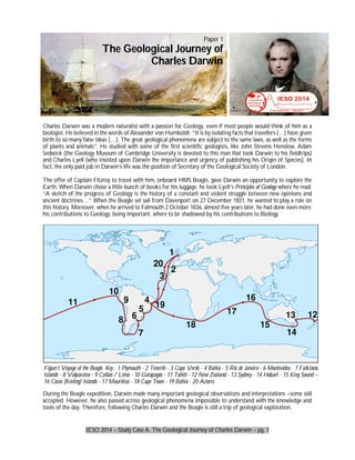
  • 1. IESO 2014 – Study Case A. The Geological Journey of Charles Darwin – pg. 1 Charles Darwin was a modern naturalist with a passion for Geology, even if most people would think of him as a biologist. He believed in the words of Alexander von Humboldt: “It is by isolating facts that travellers (…) have given birth to so many false ideas (…). The great geological phenomena are subject to the same laws, as well as the forms of plants and animals”. He studied with some of the first scientific geologists, like John Stevens Henslow, Adam Sedwick (the Geology Museum of Cambridge University is devoted to this man that took Darwin to his fieldtrips) and Charles Lyell (who insisted upon Darwin the importance and urgency of publishing his Origin of Species). In fact, the only paid job in Darwin’s life was the position of Secretary of the Geological Society of London. The offer of Captain Fitzroy to travel with him, onboard HMS Beagle, gave Darwin an opportunity to explore the Earth. When Darwin chose a little bunch of books for his luggage, he took Lyell’s Principles of Geology where he read: “A sketch of the progress of Geology is the history of a constant and violent struggle between new opinions and ancient doctrines…” When the Beagle set sail from Davenport on 27 December 1831, he wanted to play a role on this history. Moreover, when he arrived to Falmouth 2 October 1836, almost five years later, he had done even more: his contributions to Geology, being important, where to be shadowed by his contributions to Biology. During the Beagle expedition, Darwin made many important geological observations and interpretations –some still accepted. However, he also passed across geological phenomena impossible to understand with the knowledge and tools of the day. Therefore, following Charles Darwin and the Beagle is still a trip of geological exploration. Figure1.Voyage of the Beagle. Key : 1 Plymouth - 2 Tenerife - 3 Cape Verde - 4 Bahia - 5 Rio de Janeiro - 6 Montevideo - 7 Falkland Islands - 8 Valparaiso - 9 Callao / Lima - 10 Galapagos - 11 Tahiti - 12 New Zealand - 13 Sydney - 14 Hobart - 15 King Sound – 16 Cocos (Keeling) Islands - 17 Mauritius - 18 Cape Town - 19 Bahia - 20 Azores Paper 1 The Geological Journey of Charles Darwin
  • 2. IESO 2014 – Study Case A. The Geological Journey of Charles Darwin – pg. 2 1. The Beagle main target was mapping. To take precise measures it carries some 28 precision chronographs (the best then manufactured). Watches (= pengukur waktu/jam) were essential (and still are useful) to measure… a) Navigation distance b) Geographic Latitude c) Geographic Longitude d) Tide amplitude e) Coastal drift f) Sea Altitude g) Relative Humidity h) Atmospheric pressure 2. Mark ALL the tectonic plates that the Beagle crossed in its route… a) African b) Antarctic c) Arabian d) Atlantic e) Australian f) Cocos g) Eurasian h) Indian i) Nazca j) North-American k) Pacific l) South-American 3. Between the voyages of Christopher Columbus (1492-1493) and Charles Darwin (1831-1832) had passed some 350 years. Assuming that tectonic activity (pergerakan lempeng) has remained constant, Darwin found an Atlantic Ocean approximately… a) 300 m wider b) 100 m wider c) 10 m wider d) Equal in width e) 10 m narrower f) 100 m narrower g) 300 m narrower h) Impossible to know even today Modern ocean navigation gets important information from meteorological agencies and models. For instance, many institutions, using different physical and mathematical models, predict the trajectory of hurricanes. A common way to ensemble the diversity of predictions is a Spaghetti Plot (figure 2). Each individual forecasts is represented by one line, and merged into one image. 4. The purpose of a spaghetti plot is to give the user some idea of the… a) Width of the hurricane b) Reliability of the prediction c) Straightness of trajectories d) Time of arrival of hurricanes e) Area affected by hurricane 5. Which of the three areas marked (ditandai dengan huruf besar) in figure 2 provides the shortest term prediction within this diagram a) A b) B c) C d) None A B C Figure2. Spaghetti plot for tropical storm Irene, August 2011
  • 3. IESO 2014 – Study Case A. The Geological Journey of Charles Darwin – pg. 3 After a visit to Cape Verde Islands, the Beagle sailed across the Atlantic Ocean and that included the visit to St. Paul’s Rocks (figure 3). St.Paul’s Rocks (Brazil) is uninhabited set or rocky islets in the Atlantic Ocean, very close to the equator (00º55' N 29º20). The Beagle docked on the islets on 16 February 1832 and Darwin set to explore a place that was to challenge his geological knowledge. Darwin wrote “Is not this the first Island in the Atlantic which has been shown not to be of volcanic origin?” and “unlike anything which I have met with”. Late in 20th century the samples that Darwin had taken in the spot where identified as “mylonited amphibole-rich peridotites”. Mylonites were defined in the 1880s, peridotites in the 1840s and plate tectonics did not arrive until the 20th century. Hence, we can feel like the astonished Darwin. 6. According with General Atmosphere Circulation models, which wind direction should dominate in St. Pauls Rocks? a) Northward b) Eastward c) Southward d) Westward 7. Given the composition of a peridotite, an igneous rock rich in olivine, and given the setting of St. Paul’s Rocks, the most likely origin of them must be a fragment of… a) South-America or Africa continental lithosphere, trapped during the first phases of splitting. b) Some old subduction zone in the Atlantic coast, when the ocean was narrower. c) Mantle brought to the surface during the splitting of Africa and America. d) The Earth’s outer core brought to the surface by deep convection. 8. Mylonites are metamorphic rocks produced by friction and pressure. These rocks can be related to… a) Ocean ridge volcanism b) Transform fault movement c) Subduction friction d) A triple point between three plates On 22 August 1832, the Beagle was sailing from Montevideo to Bahia, North of Cape St Antonio (approx. 36º S 56º W). 9. Given the Earth radius is 6371 km and the sky was very similar to present, how far should the Beagle travel to see both  Ursae Polaris (the Northern Star) and  Octantis (very close to the Southern Cross)? a) 6371 km northwards b) 4000 km northwards c) 2000 km northwards d) 6371 km westwards e) 4000 km eastwards f) 2000 km southwards g) 4000 km southwards h) 6371 km southwards The Beagle arrived in Buenos Aires (Argentina) 311 days after its departure from Britain, on 2 Nov 1832. Until January 1833, Darwin had countless occasions to explore the Atlantic Argentina coast, the Pampa and the Patagonian regions. This rather flat area, covered by loess, hides a complex geologic history and structure. Study the following idealized profile and answer the following questions (figure 4). Cape Verde St Paul Rocks, Brazil Fernando de Norohna, Brazil Figure 3. The route of the Beagle across the Atlantic Ocean, with indication of the islands that Darwin could explore. Salvador de Bahia, Brazil
  • 4. IESO 2014 – Study Case A. The Geological Journey of Charles Darwin – pg. 4 10. Loess is a deposit that covers huge extensions of Patagonia. The thin dust is transported by the wind but it’s produced from… a) Settled volcanic ashes b) Alluvial flooded plains c) Glacial dust d) Coastal plain dunes 11. The present concentration of a hypothetic radioactive isotope (xxGx) related to original concentration has been measured in geological units 2, 8 and 9. The half-life (t½) of xxGx is 50 million years. The geological unit 2 was formed… ago (1 Ma = 1 million years). a) 10 Ma b) 30 Ma c) 50 Ma d) 70 Ma e) 90 Ma f) 110 Ma 12. The origin of geological unit 2 is necessarily related to… a) A sedimentary process b) An intrusive process c) A faulting process d) A volcanic process e) An edaphic process f) A glacial process g) An orthomagmatic dike h) A plutonic process 13. Which of the three disconformities shown in Figure 4 could be an angular discordance? a) A b) B c) C d) None Figure 4. LEFT: Schematic section of the geological units in a region of the Atlantic Coast of South America. Key: 1. Loess. 2. Igneous rock with concentration of [xxGx]=70% of original. 3. Sandstone with rodents teeth and contact metamorphism on top.4. Nummulithic Limestone. 5. Late Mesozoic Clay with Ammonites. 6. Limestone. 7. Folded Schist. 8. Granite ([xxGx]=4.42% of original). 9. Aplite ([xxGx]=6.25% of original). A, B and C. Disconformities. RIGHT: Blank disintegration diagram for isotope xxGx . 6 7 8 1 2 3 4 5 9 A B C 0 50 100 150 200 250 Time in millions of years (Ma) ParentAtoms%
  • 5. IESO 2014 – Study Case A. The Geological Journey of Charles Darwin – pg. 5 14. Which of the following pairs of units in Figure 4 show evidence of a marine regression? (Mark all the right answers) a) 9>8 b) 8>7 c) 7>6 d) 6>5 e) 5>4 f) 4>3 g) 3>2 h) 2>1 i) None 15. Referring to Figure 4, which of the following is closest to the age of the folding of unit 7? (You will need to plot the graph)( Anda harus membuat grafik peluruhan atomnya terlebih dahulu ) a) 125-150 Ma b) 150-175 Ma c) 175-200 Ma d) 200-225 Ma e) 225-250 Ma After exploring the Atlantic coast of South-America, the Beagle paid a second visit to Tierra del Fuego and sailed toward the Pacific Ocean, across the Beagle Channel. 16. In this area, Darwin could have experienced the Antarctic Circumpolar Current (ACC) but could not suspect the existence of the Antarctic Bottom Waters (AABW). Which of the following is most correct? a. ACC is a valuable wind for sailing and AABW is dangerous due to the presence of icebergs b. ACC was active in the times of Darwin and AABW is a recent current due to climate warming and Antarctic ice melting. c. ACC is very saline and AABW has a very low salinity d. ACC is a wind driven current and AABW is a density driven current 17. The Beagle channel is a valley excavated by Pleistocene glaciers and consequently it can be described as…( Selat Beagle pada awalnya adalah lembah yang terbentuk akibat gerusan glasier pada zaman Pleistocene dan karena itu dapat digambarkan sebagai ….) a. A glacial eroded horn b. A fjord inundated by sea level rise c. A periglacial environment d. A fluvial invasion of glacial crevasses e. An isostatic subsidence valley On 20th February 1835 the Beagle was in Valdivia when an earthquake hit the region. Darwin wrote in his journal: “This day has been remarkable in the annals of Valdivia for the most severe earthquake which the oldest inhabitants remember”. By 5th March, he landed in Concepcion (Chile) 36º52' S 73º01' W and found "That not a house in Concepcion or Talcuhano (the port) was standing, that seventy villages were destroyed, and that a great wave had almost washed away the ruins of Talcuhano". 18. Given the three seismograms and the provided map, choose the location of the epicentre. [Choose a, b, c ,d or e in your answer sheet] S2 S3 S1 a d b c e Figure5.A. Map of a region of Chile, with the Pacific Ocean to the West and the Andes to the East. S1, S2 and S3 are three seismic stations. The points a-e show possible epicenters of an earthquake. B. Seismograms registered in stations S1-S3, with indication of the arrival times of P and S waves (in seconds).
  • 6. IESO 2014 – Study Case A. The Geological Journey of Charles Darwin – pg. 6 Along the journey, the Beagle visited many kilometres of coast. Look at figure 6 to answer questions 19 and 20: 19. Which drawing is the best representation of the Atlantic coast of Santa Fe (Argentina)? [Choose a, b, c or d in your answer sheet] 20. Which drawing is the best representation of the Pacific coast of Concepción (Chile)? [Choose a, b, c or d in your answer sheet] Galapagos Islands are a milestone for Darwin and any later biologist. From an Earth Science point of view, they also represent a rather special setting. The geological setting in Galápagos is similar to Hawaii 21. Which of the following statements best describe the Galápagos Geological setting? a) They are on a Benioff plane b) They are on a mantle plume c) They are on a lithosphere isostasy rift d) They are on one transform fault 22. The volcanism of Galapagos Islands is… a) Of the same age in all the islands b) Of random age in the archipelago c) Older in the west d) Younger in the west e) Older in the east f) Younger in the east By the time the Beagle arrived in the Cocos-Keeling Islands, Darwin had observed a lot of evidence of uplifting processes (seashells in mountains, volcanic islands, etc.) and he felt there must be evidence of subsidence somewhere to guarantee some Earth equilibrium. In fact, The Structure and Distribution of Coral Reefs was published in 1842 as the first part of the geology of the voyage of the Beagle. In his map of coral reefs he identified two main types of reefs: “Red for active volcanoes and blue for fringing reefs”. In the Cocos-Keeling Islands, Fitzroy probed the reef and produced a precise chart that remained the standard until World War II. This precise survey and his observations allowed Darwin to develop an explanation of reef and atoll formation that is still accepted. Figure 6. Four simplified hypothetic types of coast profiles. Figure 7. Simplified tectonic setting of Galapagos Islands. Arrows show plate movement.
  • 7. IESO 2014 – Study Case A. The Geological Journey of Charles Darwin – pg. 7 23. The red reefs (enclosed with dotted lines) of Darwin’s map are essentially related to a) Subduction zones b) Dorsal zones c) Hot spots d) Transforming faults e) Continental lithosphere 24. The atolls are formed in… a) Extinct volcanoes uplifted due to mantle plumes push b) The crater of active volcanoes, producing atoll ring of corals c) The slopes of extinct, subsiding volcanoes, with the corals growing to reach sun light d) Active volcanoes of low temperature e) Active explosive volcanoes Along the trip, Darwin didn’t pay much attention to stars, but it’s sure that Fitzroy did. On Sunday, 21 Aug 1836, the Beagle crossed the Equator in his return trip to England. Along the trip, they could very often observe the constellations of the celestial equator, such as Orion. Among the stars of Orion, some are rather prominent stars, as Betelgeuse and Rigel. 25. Identify Betelgeuse in the map. [Choose a letter from A to H in your answer sheet] 26. Identify Rigel in the map. [Choose a letter from A to H in your answer sheet] Cocos – Keeling Islands Figure 8. Darwin's map of coral reefs. Some of his "red" reefs, associated to active volcanoes, are enclosed with doted lines. Some of his "blue" reefs, or fringe reefs, are enclosed with solid lines. Cocos-Keeling Islands are also marked. Figure 9. Simplified stellar map of constellation Orion