Submit Search
Upload
Svetlana Vinokurova Assessment of the condition of reed associations in the upper reaches of the Milk estuary based on remote sensing
•
0 likes
•
1,042 views
Anton Biatov
Follow
Презентация с семинара "ГИС и заповедные территории - 2017" http://pzf.gis.kh.ua
Read less
Read more
Environment
Report
Share
Report
Share
1 of 13
Download now
Download to read offline
Recommended
севморпуть
севморпуть
Александр Головизнин
сотрудники госавтоинспекции москвы рассказали школьникам, как обезопасить
Irina Kutuzova
Yuriy Protsenko Annual experience of using the GIS of the Pyriatynsky natio...
Anton Biatov
Vladimir Kletenkin Practical use of GIS in the Dvurechansky national park i...
Anton Biatov
Vasyl Korets The experience of using the geographic information system qgis...
Anton Biatov
Yuriy Strus An attempt to study the biotope distribution of black stork by ...
Anton Biatov
Roman Sizo open software and data - history, license types, beer
Anton Biatov
Galina Guz Web-database biodiversity of lugansk nature reserve in literary ...
Anton Biatov
Anton Biatov the experience of using ua vs for surveying the natural areas ...
Anton Biatov
Oleg Prilutsky Experience in organizing distributed data collection for mus...
Anton Biatov
Egor Yatsjuk Experience in collecting and organizing data using next gis an...
Anton Biatov
Natalia Brusentsova Cerviformes seu artiodactyla monitoring organization in...
Anton Biatov
Dmitry Lyashenko Geoinformation environmental mapping in Ukraine
Anton Biatov
Natalia Atamas Using a meteorological sounding balloon with a video camera ...
Anton Biatov
Natalia Kasyanova Development of gis-project of Dvorichansky national park ...
Anton Biatov
Alina Ovcharenko Mapping the territory of Slobozhansky national park for la...
Anton Biatov
Anton Biatov Vegetation indices (general concepts)
Anton Biatov
Ivan Oliynikov Using data of multiscale mapping to analyze the development ...
Anton Biatov
Sergei Gorodilov Geocoding. What, why and how
Anton Biatov
Roman Sizo Society for conservation gis - ua
Anton Biatov
Volodymyr Pasternak Application of GIS-technologies for research of forest ...
Anton Biatov
Irina Yakovleva Prospects for using modern technologies and adaptations in ...
Anton Biatov
Dmitry Dyadin the experience of using mobile gis applications for urban env...
Anton Biatov
Mykola Kozyr Git Hub and GIS from user to developer
Anton Biatov
Yevhen Skubak Use of GIS to map northern predators of mammals into the Svya...
Anton Biatov
Svetlana Vinokurova Visualization of time, web map of the dynamics of the r...
Anton Biatov
Anton Biatov - Report about ArcGIS using by ESRI conservation program in GIS...
Anton Biatov
More Related Content
Viewers also liked
Anton Biatov the experience of using ua vs for surveying the natural areas ...
Anton Biatov
Oleg Prilutsky Experience in organizing distributed data collection for mus...
Anton Biatov
Egor Yatsjuk Experience in collecting and organizing data using next gis an...
Anton Biatov
Natalia Brusentsova Cerviformes seu artiodactyla monitoring organization in...
Anton Biatov
Dmitry Lyashenko Geoinformation environmental mapping in Ukraine
Anton Biatov
Natalia Atamas Using a meteorological sounding balloon with a video camera ...
Anton Biatov
Natalia Kasyanova Development of gis-project of Dvorichansky national park ...
Anton Biatov
Alina Ovcharenko Mapping the territory of Slobozhansky national park for la...
Anton Biatov
Anton Biatov Vegetation indices (general concepts)
Anton Biatov
Ivan Oliynikov Using data of multiscale mapping to analyze the development ...
Anton Biatov
Sergei Gorodilov Geocoding. What, why and how
Anton Biatov
Roman Sizo Society for conservation gis - ua
Anton Biatov
Volodymyr Pasternak Application of GIS-technologies for research of forest ...
Anton Biatov
Irina Yakovleva Prospects for using modern technologies and adaptations in ...
Anton Biatov
Dmitry Dyadin the experience of using mobile gis applications for urban env...
Anton Biatov
Mykola Kozyr Git Hub and GIS from user to developer
Anton Biatov
Yevhen Skubak Use of GIS to map northern predators of mammals into the Svya...
Anton Biatov
Svetlana Vinokurova Visualization of time, web map of the dynamics of the r...
Anton Biatov
Anton Biatov - Report about ArcGIS using by ESRI conservation program in GIS...
Anton Biatov
Viewers also liked
(19)
Anton Biatov the experience of using ua vs for surveying the natural areas ...
Oleg Prilutsky Experience in organizing distributed data collection for mus...
Egor Yatsjuk Experience in collecting and organizing data using next gis an...
Natalia Brusentsova Cerviformes seu artiodactyla monitoring organization in...
Dmitry Lyashenko Geoinformation environmental mapping in Ukraine
Natalia Atamas Using a meteorological sounding balloon with a video camera ...
Natalia Kasyanova Development of gis-project of Dvorichansky national park ...
Alina Ovcharenko Mapping the territory of Slobozhansky national park for la...
Anton Biatov Vegetation indices (general concepts)
Ivan Oliynikov Using data of multiscale mapping to analyze the development ...
Sergei Gorodilov Geocoding. What, why and how
Roman Sizo Society for conservation gis - ua
Volodymyr Pasternak Application of GIS-technologies for research of forest ...
Irina Yakovleva Prospects for using modern technologies and adaptations in ...
Dmitry Dyadin the experience of using mobile gis applications for urban env...
Mykola Kozyr Git Hub and GIS from user to developer
Yevhen Skubak Use of GIS to map northern predators of mammals into the Svya...
Svetlana Vinokurova Visualization of time, web map of the dynamics of the r...
Anton Biatov - Report about ArcGIS using by ESRI conservation program in GIS...
Svetlana Vinokurova Assessment of the condition of reed associations in the upper reaches of the Milk estuary based on remote sensing
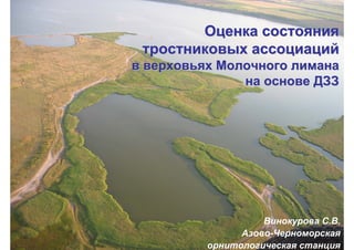
1.
ОценкаОценка состояниясостояния тростниковыхтростниковых ассоциацийассоциаций вв
верховьяхверховьях МолочногоМолочного лиманалимана нана основеоснове ДЗЗДЗЗ Винокурова С.В. Азово-Черноморская орнитологическая станция
2.
Территория исследований
3.
Исходные данные • Landsat
7, 8, Sentinel-2 за август-сентябрь
4.
Методы и ПО •
Классификация ( необучаемая и с обучением) • Вегетационные индексы • ArcGis 10.2 (лицензия по программе SCGIS Schoolarship) • QGIS и плагин Semi-Automatic Classification
5.
Промоина, соединяющая Молочный
лиман и Азовское море
6.
Динамика водного тела Молочного
лимана 2005 2009 2013
7.
Вид на верховья
Молочного лимана с дельтоплана (фото А.Шиян) • 2005 • 2009
8.
• 2005 •
2009 Состояния тростниковых зарослей (классификация ДДЗЗ)
9.
• 2015 Состояния тростниковых зарослей (классификация
ДДЗЗ) • 2017
10.
Для анализа состояния
тростниковых ассоциаций использовали спектральные индексы NDWI MNDWI NDVI NDDI
11.
Результат изменения состояния тростниковых ассоциаций
– сокращение численности некоторых гнездящихся птиц Динамика численности цапель (пар) в верховьях Молочного лимана (Бюллетень РОМ…, 2015) Фото В.Д.Сиохина
12.
Работы по оценке
влияния состояния тростниковых ассоциаций на птиц продолжаются ….
Download now