SlideShare a Scribd company logo
1 of 6
Download to read offline
Quick SQL Query
Модуль позволяет создавать наборы запросов к
конкретным базам данных, доступные для запуска нажатием
кнопки на панели инструментов «Quick SQL Query».
Модуль поддерживает работу с базами данных SpatiaLite и
PostGIS.
Модуль располагается в меню «База данных».
Позволяет создать подключение к базе данных, и создать
набор запросов доступных с панели инструментов.
Окно модуля содержит 5 вкладок «База данных», «Мои
вопросы», «Запрос», «Помощь», «О программе».
Концепция модуля для QGIS
(Биатов Антон, 2015-06-12)
Вкладка «База данных»
Настраивается подключение к базе данных.
Можно настроить подключение к нескольким базам данных.
Вкладка «Мои запросы»
Отображается список сохраненных запросов объединенных в
группы. Запросы отображаемые в этой вкладке доступны с панели
инструментов «Quick SQL Query».
Набор запросов уникален для каждой конкретной базы данных.
Переключаясь между базами при помощи выпадающего списка,
автоматически меняется и список отображаемых запросов.
Вкладка «Запрос»
Задается текст запроса, выбирается база данных к которой этот
запрос относится и задается категория и имя запроса.
Имя запроса и категория отображается во вкладке «Мои запросы»
В данном окне можно ввести любой SQL-запрос, сохранить и в
дальнейшем исполнять его одним нажатием кнопки на панели
инструментов «Quick SQL Query».
Панель инструментов
«Quick SQL Query».
В данной панели содержится выпадающее меню со списком
подключенных баз данных и кнопки исполнения сохраненных SQL-
запросов.
При смене базы данных меняется и набор кнопок с запросами.
Панель включается через меню «Вид» - «Панели инструментов»
При выполнении запроса, результат автоматически подгружается в
QGIS в виде пространственного слоя или таблицы.
Устройство
Модуль написан на Python.
Интерфейс создан при помощи Qt 4 Designer
Запросы хранятся в виде XML-файлов в пользовательской
директории QGIS. “python/plugins/QuickSQLQuery/queries/”
anton.biatov@gmail.com

More Related Content

More from Anton Biatov

Yuriy Protsenko Annual experience of using the GIS of the Pyriatynsky natio...
Yuriy Protsenko   Annual experience of using the GIS of the Pyriatynsky natio...Yuriy Protsenko   Annual experience of using the GIS of the Pyriatynsky natio...
Yuriy Protsenko Annual experience of using the GIS of the Pyriatynsky natio...Anton Biatov
 
Yevhen Skubak Use of GIS to map northern predators of mammals into the Svya...
Yevhen Skubak   Use of GIS to map northern predators of mammals into the Svya...Yevhen Skubak   Use of GIS to map northern predators of mammals into the Svya...
Yevhen Skubak Use of GIS to map northern predators of mammals into the Svya...Anton Biatov
 
Volodymyr Pasternak Application of GIS-technologies for research of forest ...
Volodymyr Pasternak   Application of GIS-technologies for research of forest ...Volodymyr Pasternak   Application of GIS-technologies for research of forest ...
Volodymyr Pasternak Application of GIS-technologies for research of forest ...Anton Biatov
 
Vladimir Kletenkin Practical use of GIS in the Dvurechansky national park i...
Vladimir Kletenkin   Practical use of GIS in the Dvurechansky national park i...Vladimir Kletenkin   Practical use of GIS in the Dvurechansky national park i...
Vladimir Kletenkin Practical use of GIS in the Dvurechansky national park i...Anton Biatov
 
Vasyl Korets The experience of using the geographic information system qgis...
Vasyl Korets   The experience of using the geographic information system qgis...Vasyl Korets   The experience of using the geographic information system qgis...
Vasyl Korets The experience of using the geographic information system qgis...Anton Biatov
 
Svetlana Vinokurova Visualization of time, web map of the dynamics of the r...
Svetlana Vinokurova   Visualization of time, web map of the dynamics of the r...Svetlana Vinokurova   Visualization of time, web map of the dynamics of the r...
Svetlana Vinokurova Visualization of time, web map of the dynamics of the r...Anton Biatov
 
Svetlana Vinokurova Assessment of the condition of reed associations in the...
Svetlana Vinokurova   Assessment of the condition of reed associations in the...Svetlana Vinokurova   Assessment of the condition of reed associations in the...
Svetlana Vinokurova Assessment of the condition of reed associations in the...Anton Biatov
 
Sergei Gorodilov Geocoding. What, why and how
Sergei Gorodilov   Geocoding. What, why and howSergei Gorodilov   Geocoding. What, why and how
Sergei Gorodilov Geocoding. What, why and howAnton Biatov
 
Roman Sizo Society for conservation gis - ua
Roman Sizo   Society for conservation gis - uaRoman Sizo   Society for conservation gis - ua
Roman Sizo Society for conservation gis - uaAnton Biatov
 
Roman Sizo open software and data - history, license types, beer
Roman Sizo   open software and data - history, license types, beerRoman Sizo   open software and data - history, license types, beer
Roman Sizo open software and data - history, license types, beerAnton Biatov
 
Oleg Prilutsky Experience in organizing distributed data collection for mus...
Oleg Prilutsky   Experience in organizing distributed data collection for mus...Oleg Prilutsky   Experience in organizing distributed data collection for mus...
Oleg Prilutsky Experience in organizing distributed data collection for mus...Anton Biatov
 
Natalia Kasyanova Development of gis-project of Dvorichansky national park ...
Natalia Kasyanova   Development of gis-project of Dvorichansky national park ...Natalia Kasyanova   Development of gis-project of Dvorichansky national park ...
Natalia Kasyanova Development of gis-project of Dvorichansky national park ...Anton Biatov
 
Natalia Brusentsova Cerviformes seu artiodactyla monitoring organization in...
Natalia Brusentsova   Cerviformes seu artiodactyla monitoring organization in...Natalia Brusentsova   Cerviformes seu artiodactyla monitoring organization in...
Natalia Brusentsova Cerviformes seu artiodactyla monitoring organization in...Anton Biatov
 
Natalia Atamas Using a meteorological sounding balloon with a video camera ...
Natalia Atamas   Using a meteorological sounding balloon with a video camera ...Natalia Atamas   Using a meteorological sounding balloon with a video camera ...
Natalia Atamas Using a meteorological sounding balloon with a video camera ...Anton Biatov
 
Mykola Kozyr Git Hub and GIS from user to developer
Mykola Kozyr   Git Hub and GIS from user to developerMykola Kozyr   Git Hub and GIS from user to developer
Mykola Kozyr Git Hub and GIS from user to developerAnton Biatov
 
Ivan Oliynikov Using data of multiscale mapping to analyze the development ...
Ivan Oliynikov   Using data of multiscale mapping to analyze the development ...Ivan Oliynikov   Using data of multiscale mapping to analyze the development ...
Ivan Oliynikov Using data of multiscale mapping to analyze the development ...Anton Biatov
 
Irina Yakovleva Prospects for using modern technologies and adaptations in ...
Irina Yakovleva   Prospects for using modern technologies and adaptations in ...Irina Yakovleva   Prospects for using modern technologies and adaptations in ...
Irina Yakovleva Prospects for using modern technologies and adaptations in ...Anton Biatov
 
Galina Guz Web-database biodiversity of lugansk nature reserve in literary ...
Galina Guz   Web-database biodiversity of lugansk nature reserve in literary ...Galina Guz   Web-database biodiversity of lugansk nature reserve in literary ...
Galina Guz Web-database biodiversity of lugansk nature reserve in literary ...Anton Biatov
 
Egor Yatsjuk Experience in collecting and organizing data using next gis an...
Egor Yatsjuk   Experience in collecting and organizing data using next gis an...Egor Yatsjuk   Experience in collecting and organizing data using next gis an...
Egor Yatsjuk Experience in collecting and organizing data using next gis an...Anton Biatov
 
Dmitry Lyashenko Geoinformation environmental mapping in Ukraine
Dmitry Lyashenko   Geoinformation environmental mapping in UkraineDmitry Lyashenko   Geoinformation environmental mapping in Ukraine
Dmitry Lyashenko Geoinformation environmental mapping in UkraineAnton Biatov
 

More from Anton Biatov (20)

Yuriy Protsenko Annual experience of using the GIS of the Pyriatynsky natio...
Yuriy Protsenko   Annual experience of using the GIS of the Pyriatynsky natio...Yuriy Protsenko   Annual experience of using the GIS of the Pyriatynsky natio...
Yuriy Protsenko Annual experience of using the GIS of the Pyriatynsky natio...
 
Yevhen Skubak Use of GIS to map northern predators of mammals into the Svya...
Yevhen Skubak   Use of GIS to map northern predators of mammals into the Svya...Yevhen Skubak   Use of GIS to map northern predators of mammals into the Svya...
Yevhen Skubak Use of GIS to map northern predators of mammals into the Svya...
 
Volodymyr Pasternak Application of GIS-technologies for research of forest ...
Volodymyr Pasternak   Application of GIS-technologies for research of forest ...Volodymyr Pasternak   Application of GIS-technologies for research of forest ...
Volodymyr Pasternak Application of GIS-technologies for research of forest ...
 
Vladimir Kletenkin Practical use of GIS in the Dvurechansky national park i...
Vladimir Kletenkin   Practical use of GIS in the Dvurechansky national park i...Vladimir Kletenkin   Practical use of GIS in the Dvurechansky national park i...
Vladimir Kletenkin Practical use of GIS in the Dvurechansky national park i...
 
Vasyl Korets The experience of using the geographic information system qgis...
Vasyl Korets   The experience of using the geographic information system qgis...Vasyl Korets   The experience of using the geographic information system qgis...
Vasyl Korets The experience of using the geographic information system qgis...
 
Svetlana Vinokurova Visualization of time, web map of the dynamics of the r...
Svetlana Vinokurova   Visualization of time, web map of the dynamics of the r...Svetlana Vinokurova   Visualization of time, web map of the dynamics of the r...
Svetlana Vinokurova Visualization of time, web map of the dynamics of the r...
 
Svetlana Vinokurova Assessment of the condition of reed associations in the...
Svetlana Vinokurova   Assessment of the condition of reed associations in the...Svetlana Vinokurova   Assessment of the condition of reed associations in the...
Svetlana Vinokurova Assessment of the condition of reed associations in the...
 
Sergei Gorodilov Geocoding. What, why and how
Sergei Gorodilov   Geocoding. What, why and howSergei Gorodilov   Geocoding. What, why and how
Sergei Gorodilov Geocoding. What, why and how
 
Roman Sizo Society for conservation gis - ua
Roman Sizo   Society for conservation gis - uaRoman Sizo   Society for conservation gis - ua
Roman Sizo Society for conservation gis - ua
 
Roman Sizo open software and data - history, license types, beer
Roman Sizo   open software and data - history, license types, beerRoman Sizo   open software and data - history, license types, beer
Roman Sizo open software and data - history, license types, beer
 
Oleg Prilutsky Experience in organizing distributed data collection for mus...
Oleg Prilutsky   Experience in organizing distributed data collection for mus...Oleg Prilutsky   Experience in organizing distributed data collection for mus...
Oleg Prilutsky Experience in organizing distributed data collection for mus...
 
Natalia Kasyanova Development of gis-project of Dvorichansky national park ...
Natalia Kasyanova   Development of gis-project of Dvorichansky national park ...Natalia Kasyanova   Development of gis-project of Dvorichansky national park ...
Natalia Kasyanova Development of gis-project of Dvorichansky national park ...
 
Natalia Brusentsova Cerviformes seu artiodactyla monitoring organization in...
Natalia Brusentsova   Cerviformes seu artiodactyla monitoring organization in...Natalia Brusentsova   Cerviformes seu artiodactyla monitoring organization in...
Natalia Brusentsova Cerviformes seu artiodactyla monitoring organization in...
 
Natalia Atamas Using a meteorological sounding balloon with a video camera ...
Natalia Atamas   Using a meteorological sounding balloon with a video camera ...Natalia Atamas   Using a meteorological sounding balloon with a video camera ...
Natalia Atamas Using a meteorological sounding balloon with a video camera ...
 
Mykola Kozyr Git Hub and GIS from user to developer
Mykola Kozyr   Git Hub and GIS from user to developerMykola Kozyr   Git Hub and GIS from user to developer
Mykola Kozyr Git Hub and GIS from user to developer
 
Ivan Oliynikov Using data of multiscale mapping to analyze the development ...
Ivan Oliynikov   Using data of multiscale mapping to analyze the development ...Ivan Oliynikov   Using data of multiscale mapping to analyze the development ...
Ivan Oliynikov Using data of multiscale mapping to analyze the development ...
 
Irina Yakovleva Prospects for using modern technologies and adaptations in ...
Irina Yakovleva   Prospects for using modern technologies and adaptations in ...Irina Yakovleva   Prospects for using modern technologies and adaptations in ...
Irina Yakovleva Prospects for using modern technologies and adaptations in ...
 
Galina Guz Web-database biodiversity of lugansk nature reserve in literary ...
Galina Guz   Web-database biodiversity of lugansk nature reserve in literary ...Galina Guz   Web-database biodiversity of lugansk nature reserve in literary ...
Galina Guz Web-database biodiversity of lugansk nature reserve in literary ...
 
Egor Yatsjuk Experience in collecting and organizing data using next gis an...
Egor Yatsjuk   Experience in collecting and organizing data using next gis an...Egor Yatsjuk   Experience in collecting and organizing data using next gis an...
Egor Yatsjuk Experience in collecting and organizing data using next gis an...
 
Dmitry Lyashenko Geoinformation environmental mapping in Ukraine
Dmitry Lyashenko   Geoinformation environmental mapping in UkraineDmitry Lyashenko   Geoinformation environmental mapping in Ukraine
Dmitry Lyashenko Geoinformation environmental mapping in Ukraine
 

Quick SQL query QGIS conception

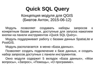
  • 1. Quick SQL Query Модуль позволяет создавать наборы запросов к конкретным базам данных, доступные для запуска нажатием кнопки на панели инструментов «Quick SQL Query». Модуль поддерживает работу с базами данных SpatiaLite и PostGIS. Модуль располагается в меню «База данных». Позволяет создать подключение к базе данных, и создать набор запросов доступных с панели инструментов. Окно модуля содержит 5 вкладок «База данных», «Мои вопросы», «Запрос», «Помощь», «О программе». Концепция модуля для QGIS (Биатов Антон, 2015-06-12)
  • 2. Вкладка «База данных» Настраивается подключение к базе данных. Можно настроить подключение к нескольким базам данных.
  • 3. Вкладка «Мои запросы» Отображается список сохраненных запросов объединенных в группы. Запросы отображаемые в этой вкладке доступны с панели инструментов «Quick SQL Query». Набор запросов уникален для каждой конкретной базы данных. Переключаясь между базами при помощи выпадающего списка, автоматически меняется и список отображаемых запросов.
  • 4. Вкладка «Запрос» Задается текст запроса, выбирается база данных к которой этот запрос относится и задается категория и имя запроса. Имя запроса и категория отображается во вкладке «Мои запросы» В данном окне можно ввести любой SQL-запрос, сохранить и в дальнейшем исполнять его одним нажатием кнопки на панели инструментов «Quick SQL Query».
  • 5. Панель инструментов «Quick SQL Query». В данной панели содержится выпадающее меню со списком подключенных баз данных и кнопки исполнения сохраненных SQL- запросов. При смене базы данных меняется и набор кнопок с запросами. Панель включается через меню «Вид» - «Панели инструментов» При выполнении запроса, результат автоматически подгружается в QGIS в виде пространственного слоя или таблицы.
  • 6. Устройство Модуль написан на Python. Интерфейс создан при помощи Qt 4 Designer Запросы хранятся в виде XML-файлов в пользовательской директории QGIS. “python/plugins/QuickSQLQuery/queries/” anton.biatov@gmail.com