

Recommended
Recommended
More Related Content
Similar to Climatology Intro.pptx
Similar to Climatology Intro.pptx (20)
More from Harish Gupta
More from Harish Gupta (6)
Recently uploaded
Recently uploaded (20)
Climatology Intro.pptx
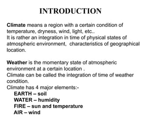
- 1. INTRODUCTION Climate means a region with a certain condition of temperature, dryness, wind, light, etc.. It is rather an integration in time of physical states of atmospheric environment, characteristics of geographical location. Weather is the momentary state of atmospheric environment at a certain location . Climate can be called the integration of time of weather condition. Climate has 4 major elements:- EARTH – soil WATER – humidity FIRE – sun and temperature AIR – wind
- 2. ARCHITECTURAL CLIMATOLOGY Architecture is all about ART and TECHNOLOGY. It includes public services, water supply and drainage, air conditioning, ventilation, lighting, etc. it is the basic science a designer is concerned about. It involves majorly on:- climatic elements how they are behaving on us how to be benefited by these climatic elements how to protect ourselves from the adverse effect of climatic elements The major steps in architectural climatology are:-
- 4. Site planning in landscape architecture and architecture refers to the organizational stage of the design process. It involves the organization of land use zoning, access, circulation, privacy, security, shelter, land drainage, and other factors. This is done by arranging the compositional elements of landform, planting, water, buildings and paving and building. Site planning generally begins by assessing a potential site for development through site analysis. Information about slope, soils, hydrology, vegetation, parcel ownership, orientation, etc. are assessed and mapped. By determining areas that are poor /better for development, the architect can assess optimal location and design a structure that works there. So the major concerns of planning are:- Topography Air temperature Humidity Precipitation Air movement Vegetation and local factors
- 5. TOPOGRAPHY topography is concerned with local detail in general, including not only relief but also vegetative and human- made features, and even local history and culture. TOPOGRAPHIC MAPPING In its contemporary definition, topographic mapping shows relief. In the United States, USGS topographic maps show relief using contour lines. These maps show not only the contours, but also any significant streams or other bodies of water, forest cover, built-up areas or
- 6. The Elements of Climate :-Climatology is the study of the long-term state of the atmosphere, or climate. The long-term state of the atmosphere is a function of a variety of interacting elements. They are: - 1. Solar radiation 2. Air masses 3. Pressure systems (and cyclone belts) 4. Ocean Currents 5. Topography 1. Solar radiation :- • Solar radiation is probably the most important element of climate. • Solar radiation first and foremost heats the Earth's surface which in turn determines the temperature of the air above. • The receipt of solar radiation drives evaporation, so long as there is water available. • Heating of the air determines its stability, which affects cloud development and precipitation. • Unequal heating of the Earth's surface creates pressure gradients that result in wind. 2. Air masses :- • Air masses as an element of climate subsumes the characteristics of temperature, humidity, and stability. • Location relative to source regions of air masses in part determines the variation of the day- to-day weather and long-term climate of a place. • For instance, the stormy climate of the mid latitudes is a product of lying in the boundary zone of greatly contrasting air masses called the polar front.
- 7. 3.Pressure systems :- •Pressure systems have a direct impact on the precipitation characteristics of different climate regions. •In general, places dominated by low pressure tend to be moist, while those dominated by high pressure are dry. •The seasonality of precipitation is affected by the seasonal movement of global and regional pressure systems. Climates located at 10o to 15o of latitude experience a significant wet period when dominated by the Intertropical Convergence Zone and a dry period when the Subtropical High moves into this region. •Likewise, the climate of Asia is impacted by the annual fluctuation of wind direction due to the monsoon. • Pressure dominance also affects the receipt of solar radiation. Places dominated by high pressure tend to lack cloud cover and hence receive significant amounts of sunshine, especially in the low latitudes. 4.Ocean Currents :- •Ocean currents greatly affect the temperature and precipitation of a climate. •Those climates bordering cold currents tend to be drier as the cold ocean water helps stabilize the air and inhibit cloud formation and precipitation. •Air traveling over cold ocean currents lose energy to the water and thus moderate the temperature of nearby coastal locations. •Air masses traveling over warm ocean currents promote instability and precipitation. Additionally, the warm ocean water keeps air temperatures somewhat warmer than locations just inland from the coast during the winter.
- 8. 5.Topography :- •Topography affects climate in a variety of ways. •The orientation of mountains to the prevailing wind affects precipitation. •Windward slopes, those facing into the wind, experience more precipitation due to orographic uplift of the air. • Leeward sides of mountains are in the rain shadow and thus receive less precipitation. •Air temperatures are affected by slope and orientation as slopes facing into the Sun will be warmer than those facing away. •Temperature also decreases as one moves toward higher elevations. •Mountains have nearly the same affect as latitude does on climate. •On tall mountains a zonation of climate occurs as you move towards higher elevation.
- 9. climate classification system. The system is based on the concept that native vegetation is the best expression of climate. Thus, climate zone boundaries have been selected with vegetation distribution in mind. It combines average annual and monthly temperatures and precipitation, and the seasonality of precipitation. 1 .1 GROUP A: Tropical Climate 1.2 GROUP B: Dry (arid and semiarid) Climate 1.3 GROUP C: Mild Temperate Climate 1.4 GROUP D: Continental Climate 1.5 GROUP E: Polar Climate
- 13. ORIENTATION:- •A buildings orientation is important to its overall energy efficiency, this article explains this in detail and describes the steps you need to take to get best benefit from the correct orientation. This could save you thousands whilst reducing your impact on the environment. •A correctly orientated building can save a lot of money in no longer required heating and cooling costs expenditure - in effect the building itself maintains a comfortable environment for you with little additional costs. This is especially relevant with rising fuels bills and the increasing costs of electricity. By simply building this way, a house can reduce its heating and cooling costs by 85%. •An extra benefit is that there is nothing as such to break down or fail with the orientation, hence it being called 'Passive Solar', so nearly zero maintenance costs to incur during the lifetime of the building. The ideal house solar orientation for Passive Solar benefit is that the main long axis of the building runs East-West, i.e the ridge line. You can move this by as much as 20 degrees without ill effect, but the most glass on the building must be facing towards the Sun. When deciding the building orientation also take into account the location of landscape features on your plot , i.e. trees and walls, etc which will impact on how you harness the Sun. Ideally you do not want them blocking the Sun light as the Sun tracks across the sky in Winter. So trees with high branches as especially beneficial if placed to the East or West of the building, as they will shade in Summer let allow the Sun light through in Winter. Ideal Building orientation
- 14. Orientate your building to use the Sun to your advantage •The fact the Sun is lower in the sky in Winter than in Summer allows us to plan and construct buildings that capture that free heat in Winter and reject the unneeded heat in Summer. The solar orientation of the whole building plays an important part in ensuring such a 'passive' process works consistently. Please refer to the diagram below for an explanation. •The 'trick' with Passive Solar is in Summer to use shade to block the Sun heating up the interior of the property, but do so that is just enough to to stop it; then when the Sun goes lower in the Winter that shade is no longer enough to prevent the Sun coming into the property and you get free heat just when you need it.