Call Girls In Andheri East Call US Pooja📞 9892124323 Book Hot And
Module iii notes
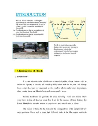
1. Classification of Flood:
1) River Flood:
It occurs when excessive rainfall over an extended period of time causes a river to
exceed its capacity. It can also be caused by heavy snow melt and ice jams. The damage
from a river flood can be widespread as the overflow affects smaller rivers downstream,
often causing dams and dikes to break and swamp nearby areas.
Riverine floodplains are generally flat areas bordering rivers and streams where
water flows in time of flood or would flow if not for the presence of flood defenses like
levees. Floodplains are quite narrow in canyons and upto several wide in valleys.
The erosion of banks by the rivers and the consequent loss of life and property are
major problems. Rivers tend to erode their beds and banks in the hilly regions resulting in
2. the deepening and widening of rivers. When a river enters the flood plains, it shows a
tendency to braid and develop number of channels causing silting of the riverbed, change
in course and bank erosion. In the plains, a river shows a meandering tendency with
meanders moving downstream causing erosion on the concave and deposition on the
convex side and cut offs. This causes large-scale bank erosion. In deltaic reaches near the
outfall into sea, the river divides itself into a number of branches resulting in bank
erosion. Thus bank erosion and consequent loss of land and properties is a constant
phenomenon all along the course of the river.
There are two main types of river flooding:
Overbank flooding occurs when water rises overflows over the edges of a river or stream.
This is the most common and can occur in any size channel — from small streams to
huge rivers.
Flash flooding is characterized by an intense, high velocity torrent of water that occurs in
an existing river channel with little to no notice. Flash floods are very dangerous and
destructive not only because of the force of the water, but also the hurtling debris that is
often swept up in the flow.
2) Coastal Flood:
Coastal flooding occurs when normally dry, low-lying land is flooded by seawater. The
extent of coastal flooding is a function of the elevation inland flood waters penetrate which is
controlled by the topography of the coastal land exposed to flooding. Coastal floodplains are
generally flat areas bordering the oceans. The seawater can inundate the land via several
different paths:
a) Direct inundation — where the sea height exceeds the elevation of the land, often where
waves have not built up a natural barrier such as a dune system
b) Overtopping of a barrier — the barrier may be natural or human engineered and
overtopping occurs due to swell conditions during storm or high tides often on open
stretches of the coast. The height of the waves exceeds the height of the barrier and
water flows over the top of the barrier to flood the land behind it. Overtopping can result
3. in high velocity flows that can erode significant amounts of the land surface which can
undermine defense structures.
c) Breaching of a barrier — again the barrier may be natural or human engineered, and
breaching occurs on open coasts exposed to large waves. Breaching is where the barrier
is broken down by waves allowing the seawater to extend inland.
Coastal flooding is largely a natural event, however human influence on the coastal
environment can exacerbate coastal flooding. Extraction of water from groundwater
reservoirs in the coastal zone can enhance subsidence of the land increasing the risk of
flooding. Engineered protection structures along the coast such as sea walls alter the natural
processes of the beach, often leading to erosion on adjacent stretches of the coast which also
increases the risk of flooding.
3) Storm Surges:
A storm surge, storm flood or storm tide is a coastal flood or tsunami-like phenomenon of
rising water commonly associated with low pressure weather systems (such as tropical
cyclones and strong extratropical cyclones), the severity of which is affected by the
shallowness and orientation of the water body relative to storm path, as well as the timing
of tides. Most casualties during tropical cyclones occur as the result of storm surges. It is a
measure of the rise of water beyond what would be expected by the normal movement
related to tides.
The two main meteorological factors contributing to a storm surge are a long fetch of
winds spiraling inward toward the storm, and a low-pressure-induced dome of water drawn
up under and trailing the storm's center.
At least five processes can be involved in altering tide levels during storms:
a) The atmospheric pressure effect
b) The direct wind effect
c) The effect of the Earth's rotation
d) The effect of waves near the shore
4. e) The rainfall effect.
The pressure effects of a tropical cyclone will cause the water level in the open ocean to
rise in regions of low atmospheric pressure and fall in regions of high atmospheric pressure.
The rising water level will counteract the low atmospheric pressure such that the total
pressure at some plane beneath the water surface remains constant. This effect is estimated at
a 10 mm (0.39 in) increase in sea level for every millibar (hPa) drop in atmospheric pressure.
Strong surface winds cause surface currents at a 45° angle to the wind direction, by an
effect known as the Ekman Spiral. Wind stresses cause a phenomenon referred to as "wind
set-up", which is the tendency for water levels to increase at the downwind shore and to
decrease at the upwind shore. Intuitively, this is caused by the storm blowing the water
toward one side of the basin in the direction of its winds. Because the Ekman Spiral effects
spread vertically through the water, the effect is proportional to depth. The pressure effect
and the wind set-up on an open coast will be driven into bays in the same way as the
astronomical tide.[11]
The Earth's rotation causes the Coriolis effect, which bends currents to the right in the
Northern Hemisphere and to the left in the Southern Hemisphere. When this bend brings the
currents into more perpendicular contact with the shore, it can amplify the surge, and when it
bends the current away from the shore it has the effect of lessening the surge.[11]
The effect of waves, while directly powered by the wind, is distinct from a storm's wind-
powered currents. Powerful wind whips up large, strong waves in the direction of its
movement.[11] Although these surface waves are responsible for very little water transport in
open water, they may be responsible for significant transport near the shore. When waves are
breaking on a line more or less parallel to the beach, they carry considerable water
shoreward. As they break, the water particles moving toward the shore have considerable
momentum and may run up a sloping beach to an elevation above the mean water line, which
may exceed twice the wave height before breaking.[12]
The rainfall effect is experienced predominantly in estuaries. Hurricanes may dump as
much as 12 in (300 mm) of rainfall in 24 hours over large areas and higher rainfall densities
5. in localized areas. As a result, surface runoff can quickly flood Streams and rivers. This can
increase the water level near the head of tidal estuaries as storm-driven waters surging in
from the ocean meet rainfall flowing downstream into the estuary.
4) Areal Flood:
An Areal Flood Warning is normally issued for flooding that develops more gradually,
usually from prolonged and persistent moderate to heavy rainfall. This results in a gradual
ponding or buildup of water in low-lying, flood prone areas, as well as small creeks and
streams. The flooding normally occurs more than six hours after the rainfall begins, and may
cover a large area. However, even though this type of flooding develops more slowly than
flash flooding, it can still be a threat to life and property.
5) Urban Flood:
Flooding in urban areas can be caused by flash floods, or coastal floods, or river floods,
but there is also a specific flood type that is called urban flooding.
Urban flooding is specific in the fact that the cause is a lack of drainage in an urban area.
As there is little open soil that can be used for water storage nearly all the precipitation needs
to be transport to surface water or the sewage system. High intensity rainfall can cause
flooding when the city sewage system and draining canals do not have the necessary capacity
to drain away the amounts of rain that are falling. Water may even enter the sewage system
in one place and then get deposited somewhere else in the city on the streets. Sometimes you
see dancing drain covers.
Urban floods are a great disturbance of daily life in the city. Roads can be blocked,
people can’t go to work or to schools. The economic damages are high but the number of
casualties is usually very limited, because of the nature of the flood. The water slowly rises
on the city streets. When the city is on flat terrain the flow speed is low and you can still see
people driving through it. The water rises relatively slow and the water level usually does not
reach life endangering heights.
6. 6) Flash Floods:
In areas with steep slopes, heavy rain can cause a riverbed that held very little or no water
at first, to suddenly brim with fast flowing water. The rain water is collected on the slopes,
then flows downhill gathering speed and all the water comes together in the river bed. The
water level rises fast. The water flows over the river banks and floods the area. Speed is the
keyword. It all happens fast, it rains heavily. The water flows at high speed. Because of this
speed it has the strength to carry away heavy objects.The flood stops as suddenly as it starts.
A flash flood is a very direct response to rainfall with a very high intensity or sudden
massive melting of snow.
The area covered by water in a flash flood is relatively small compared to other types of
floods. The amount of water that covers the land is usually not very large, but is so
concentrated on a small area that it can rise very high.
Because of the sudden onset and the high travelling speed of the water, flash floods can
be very dangerous. The water can transport large objects like rocks, trees and cars. Never
drive through a flash flood, even if it doesn’t seem to be very deep: the car may be swept
away by the sheer speed of the water.
When a dyke breaks along the sea or along a river, the water may flow in so suddenly and
with such speed that you could compare it with a flash flood.
7) Catastrophic Flood:
Catastrophic riverine flooding is usually associated with major infrastructure failures
such as the collapse of a dam, but they may also be caused by drainage channel modification
from a landslide, earthquake or volcanic eruption. Examples include outburst
floods and lahars. Tsunamis can cause catastrophic coastal flooding, most commonly
resulting from undersea earthquakes.
7. Causes of Floods:
• Floods are caused by many things.
• One cause of a flood is when water exceeds the capacity of the area it is in; thus causing
it to overflow outside the waters boundary.
• Another cause is the amount of rain that a certain area of land gets.
• Dam breaks, gate failure,etc.
• Climates and environments have a lot to do with flooding also. A higher altitude might be
exposed to more rain than a lower altitude.
• Also a damper, wetter climate creates it more susceptible for rain, which causes it to
flood (flash flood) more frequently than a hot and dry climate.
• Hurricanes also effect floods to. When a hurricane reaches land, there is an enormous
amount of water that is carried along with it. This water dumped on land and as water
levels rise, flooding is created.
.
8. Some of the causes are explained below:
a. Heavy Rainfall:
No matter where you live , you are surrounded by infrastructure and systems
designed to move rainwater into appropriate basins and reservoirs
When it rains heavily, those systems are overwhelmed and that water does’nt
drain quickly as it needs to
Happens in case of sustained heavy rains for over a long period
b. Overflowing Rivers:
Not necessarily due to heavy rainfall
If excess rainfall in upstream areas, it will cause flood in downstream
May be due to uncontrolled release from dams, etc.
c. Broken Dams:
When heavy rains come, water level rises
Aging dams may fail and unleash torrents of water on unsuspecting households
d. Urban Drainage Basins:
Cities mostly made of concrete and impermeable material
Concrete drainage basins have no ground for water to sink into
When those drainage basins fill up – causes flooding in low lying areas
e. Storm Surges and Tsunamis:
Storm surges related to hurricanes and other storms can lead to significant
flooding as Tsunamis are sometimes caused by underground Earthquakes
f. Channels with steepsides:
Flooding often occurs when there is fast runoff into lakes, rivers and other
channels that have steep sides
g. Lack of Vegetation
h. Melting Snow and Ice
A winter of heavy snow and precipitation can lead to a spring of flooding
Most mountainous areas experience relatively consistent snowfall from year to
year, but an unusually heavy winter of precipitation can spell bad news for low
lying areas of mountains when spring hits
9.
10. Flood Impacts:
Hazards associated with flooding can be divided into primary hazards that occur due to
contact with water, secondary effects that occur because of the flooding, such as
disruption of services, health impacts such as famine and disease, and tertiary effects
such as changes in the position of river channels. Throughout the last century flooding
has been one of the most costly disasters in terms of both property damage and human
casualties.
Primary Effects
Again, the primary effects of floods are those due to direct contact with the flood
waters. As seen in the video last lecture, water velocities tend to be high in floods. As
discharge increases velocity increases.
With higher velocities, streams are able to transport larger particles as suspended load.
Such large particles include not only rocks and sediment, but, during a flood, could
include such large objects as automobiles, houses and bridges.
Massive amounts of erosion can be accomplished by flood waters. Such erosion can
undermine bridge structures, levees, and buildings causing their collapse.
Water entering human built structures cause water damage. Even with minor flooding
of homes, furniture is ruined, floors and walls are damaged, and anything that comes in
contact with the water is likely to be damaged or lost. Flooding of automobiles usually
results in damage that cannot easily be repaired.
The high velocity of flood waters allows the water to carry more sediment as suspended
load. When the flood waters retreat, velocity is generally much lower and sediment is
deposited. After retreat of the floodwaters everything is usually covered with a thick
layer of stream deposited mud, including the interior of buildings.
Flooding of farmland usually results in crop loss. Livestock, pets, and other animals are
often carried away and drown.
Humans that get caught in the high velocity flood waters are often drowned by the
water.
11. Floodwaters can concentrate garbage, debris, and toxic pollutants that can cause the
secondary effects of health hazards.
Secondary and Tertiary Effects
Remember that secondary effects are those that occur because of the primary effects and
tertiary effects are the long term changes that take place. Among the secondary effects of a
flood are:
Disruption of services -
o Drinking water supplies may become polluted, especially if sewerage treatment plants are
flooded. This may result in disease and other health effects, especially in under
developed countries.
o Gas and electrical service may be disrupted.
o Transportation systems may be disrupted, resulting in shortages of food and clean-up
supplies. In under developed countries food shortages often lead to starvation.
Long - term effects (tertiary effects)-
oLocation of river channels may change as the result of flooding, new channels develop,
leaving the old channels dry.
oSediment deposited by flooding may destroy farm land (although silt deposited by
floodwaters could also help to increase agricultural productivity).
oJobs may be lost due to the disruption of services, destruction of business, etc. (although
jobs may be gained in the construction industry to help rebuild or repair flood damage).
oInsurance rates may increase.
oCorruption may result from misuse of relief funds.
oDestruction of wildlife habitat.
12. Vulnerabilities to flooding:
Vulnerability describes the characteristics and circumstances of a community that make it
susceptible to the damaging effects of a hazard.
The following can make us more vulnerable to flooding:
Physical Vulnerability
1. Building homes on the river bank or on flood plains.
2. Constructing new housing settlements without improving the existing drainage system, thus
overwhelming the drainage system.
3. The construction of residential or commercial buildings without taking into consideration
the current and future flooding impacts can increase ones vulnerability.
4. Living close to the coast can make one vulnerable to storm surges and coastal flooding.
5. Lack of maintenance of drains and waterways.
Social Vulnerability
1. Lack of education on the causes and mitigation measures that one can use to reduce the
effects of flooding.
2. Family Structure- Female headed households and households with a large number of
dependencies are considered to be more vulnerable to the negative impacts of disasters.
Economic Vulnerability
1. Unemployment impairs the amount of monetary resources that one to reduce one’s
vulnerability to flooding.
2. Debt reduces ability to recover from flood damages
3. Living in coastal areas prone to coastal flooding because of livelihood, e.g., fishing.
Environmental Vulnerability
1. Deforestation or the removal of forest or vegetative cover from land would result in
increased flooding and would increase an area’s vulnerability.
13. 2. Pollution and the indiscriminate dumping of garbage into drains and waterways would
increase flooding events.
3. Forest fires/bush fires leave the land barren and devoid of vegetation, which increases
surface runoff and increases one’s vulnerability to flooding.
Flood Disaster Management
I. Pre-Flood Disaster Stage
o Flood Preparedness
o Flood Prevention
o Flood Mitigation
II. Post-Flood Disaster Stage
o Rescue
o Relief
o Recovery
o Rehabilitation
Out of the seven steps most important are:
o Flood Control Measures –Flood Prevention and Mitigation
o Flood Forecasting Measures - Flood Preparedness
Following Flood control measures should be adopted to mitigate the adverse impacts of
severe floods and prevent ordinary floods:
o Delay the return of runoff resulting from torrential rainfall to the rivers
Large scale reforestation and afforestation in hilly source catchment areas --Delay by
intercepting the rainfall water and the ground cover holds water ---Encourages more
infiltration of rain water -- Reduce soil erosion thereby reducing sediment load of
rivers
14. o Hasten the discharge of river water
a) Sinuous and meandering rivers retards the quick disposal of water- so straighten them
at some locations by performing artificial cutoffs
b) Main difficulty is that meandering is a natural process. So if there are removed at
some locations, it will be automatically developed at some other locations
c) Restricted use of flood-plains
o Reduce the Volume of Water
a) Reduce the volume of flood stage of a river
b) Construction of flood control storage reservoirs
c) If reservoirs are followed by huge dams, then it can create hydroelectricity
o Divert the flow of rivers
a) Imply Diversion of flood water in lowlying areas, depressions or artificially
constructed channels bordered by artificial dykes so that flood crests may be reduced
b) Revetments, Channel Walls, gabions-strengthen river banks from erosion using large
lumps of stone
o Reduce the impact of floods
a) Embankments, Dikes and Flood Walls are used to confine the flood water within the
valley or within a narrow channel
b) Engineered structures include
The building of artificial levees of earthen materials, stones or even concrete
walls
Stone Spurs are used to Protect the towns, cities and other important places from
severe erosion during and after the floods
15.
16. In the post disaster stage, the main stages involved are Rescue, Relief, Recovery and
Rehabilitation.
17. TROPICAL CYCLONES
A tropical cyclone is a storm system characterized by a low pressure center and a numerous
thunder storms that produce strong winds and flooding rain .
• They are tropical, meaning that they are generated in tropical areas of the ocean near the
Equator
• They are cyclonic, meaning that their winds swirl around a central eye. Wind direction is
counter clockwise(west to east) in the Northern Hemisphere and clockwise (east to west)
in the Southern Northern Hemisphere and clockwise (east to west) in the Southern
Hemisphere (more about this later).
• They are low-pressure systems. The eye of a hurricane is always a low-pressure area.
18. How Cyclones are Formed?
• Tropical Cyclones require two basic conditions to form: an abundant supply of very
warm ocean water and some sort of disturbance to lift warm air and keep it rising.
19.
20.
21. Types of Cyclone
1) Tropical waves
Tropical waves, easterly waves, or tropical easterly waves, also known as African
easterly waves in the Atlantic region, are a type of atmospheric trough, an elongated
area of relatively low air pressure, oriented north to south, which moves from east to
west across the tropics, causing areas of cloudiness and thunderstorms.
2) Tropical Depression
The weakest is called a tropical depression with a maximum wind speed of up to 63
kilometers per hour (kph). A depression exist when there is low pressure over a large
enough area to be plotted on the weather map. The low pressure near the ocean
22. surface draws in warm, moist air which feeds more thunderstorm. The winds swirl
slowly around the low pressure area at first. As the pressure becomes even lower,
more warm, moist air is drawn in, and the winds blow faster
3) Tropical Storm
A tropical storm has developed when the maximum wind speed is 64 to 118 kph (25
to 75 mph) and with closed isobars. Near the center of a tropical storm is a column of
warm air, The warmer the column is, the lower the pressure at the surface falls. The
low pressure, in turn draws more air into the storm. As more air is pulled into the
storm, the winds blow harder.
4) Hurricane/Typhoon Cyclone
Typhoon- is an intense tropical cyclone with maximum wind speed exceeding 118
kph. Typhoon or hurricane has a well developed eye at its center, surface pressure
drops to its lowest in the eye. In the eye wall of the hurricane is its strongest winds.
The warm air spirals upward. The speed of the winds in the eye wall is related to the
diameter of the eye.
A hurricane’s winds blow faster if its eye is small. If the eye widens, the winds
decrease. Very heavy rains fall from the eyewall and bands of the hurricane. The
dense clouds that swirl around the eyewall are called rainbands. They can produce
more than 5cm of rain per hour that can cause floods, and flash floods
Impacts of Cyclones:
The main effects of tropical cyclones include heavy rain, strong wind, large storm
surges near landfall, and tornadoes. The destruction from a tropical cyclone, such as
a hurricane or tropical storm, depends mainly on its intensity, its size, and its location. Tropical
cyclones act to remove forest canopy as well as change the landscape near coastal areas, by
moving and reshaping sand dunes and causing extensive erosion along the coast. Even well
inland, heavy rainfall can lead to mudslides and landslides in mountainous areas.
23. After the cyclone has passed, devastation often continues. Fallen trees can block roads and delay
rescues, with medical supplies, or slow the repairs to electrical lines, telephone towers or water
pipes, which could put other lives at risk for days or months. Standing water can cause the spread
of disease, and transportation or communication infrastructure may have been destroyed,
hampering clean-up and rescue efforts. Nearly two million people have died globally due to
tropical cyclones. Despite their devastating effects, tropical cyclones are also beneficial, by
potentially bringing rain to dry areas and moving heat from the tropics poleward. Out at sea,
ships take advantage of their known characteristics by navigating through their weaker, western
half.
Strong winds can damage or destroy vehicles, buildings, bridges, trees, personal
property and other outside objects, turning loose debris into deadly flying projectiles. Tropical
cyclones often knock out power to tens or hundreds of thousands of people, preventing vital
communication and hampering rescue efforts. Tropical cyclones often destroy key bridges,
overpasses, and roads, complicating efforts to transport food, clean water, and medicine to the
areas that need it. Furthermore, the damage caused by tropical cyclones to buildings and
dwellings can result in economic damage to a region, and to a Diaspora of the population of the
region.
The storm surge, or the increase in sea level due to the cyclone, is typically the worst
effect from land falling tropical cyclones, historically resulting in 90% of tropical cyclone
deaths. The relatively quick surge in sea level can move miles/kilometers inland, flooding
homes and cutting off escape routes. The storm surges and winds of hurricanes may be
destructive to human-made structures, but they also stir up the waters of coastal estuaries, which
are typically important fish-breeding locales.
The thunderstorm activity in a tropical cyclone produces intense rainfall, potentially
resulting in flooding, mudslides, and landslides. Inland areas are particularly vulnerable to
freshwater flooding, due to residents not preparing adequately. Heavy inland rainfall eventually
flows into coastal estuaries, damaging marine life in coastal estuaries. The wet environment in
the aftermath of a tropical cyclone, combined with the destruction of sanitation facilities and a
warm tropical climate, can induce epidemics of disease which claim lives long after the storm
24. passes. Infections of cuts and bruises can be greatly amplified by wading in sewage-
polluted water. Large areas of standing water caused by flooding also contribute to mosquito-
borne illnesses. Furthermore, crowded evacuees in shelters increase the risk of disease
propagation.
The broad rotation of a land-falling tropical cyclone often spawns tornadoes, particularly
in their right front quadrant. While these tornadoes are normally not as strong as their non-
tropical counterparts, heavy damage or loss of life can still occur. Tornadoes can also be
spawned as a result of eyewall mesovortices (small scale rotational features found in the
eyewalls of intense tropical cyclones), which persist until landfall.
PREVENTIVE MEASURES
Here we are going to see the ten key principles of cyclone resistant construction;
Choose the location carefully to avoid the full force of wind or flood.
Use building layout , with a simple regular shape to avoid the concentration of
pressure.
Build the roof at an angle 30 to 45 degree to prevent it being lifted off by the wind.
Avoid wide roof overhangs; separate the verandah structure from the house.
Make sure the foundations ,walls and roof structure are all firmly fixed together.
Reinforce the bracings in the structure; strengthen walls and joints/junctions to
increase stiffness.
Make sure that the roof covering is firmly attached to the roof structure to prevent it
from lifting.
Use doors and shutters that can be closed.
Plant trees around the house as wind breaks and reduce flow of water, but not too
close.
25.
26. TSUNAMIS
A tsunami or tidal wave also known as a seismic sea wave, is a series of waves in a
water body caused by the displacement of a large volume of water, generally in an ocean or
a large lake. Earthquakes, volcanic eruptions and other underwater explosions(including
detonations, landslides, glacier calvings, meteorite impacts and other disturbances above or
below water all have the potential to generate a tsunami. Unlike normal ocean waves, which are
generated by wind, or tides, which are generated by the gravitational pull of the Moon and the
Sun, a tsunami is generated by the displacement of water.
Some Important facts about Tsunamis:
Some tsunamis can be very large. In coastal areas their height can be as great as 10m or more
(30m in extreme cases), and they can move inland several hundred meters.
All low-lying coastal areas can be struck by tsunamis.
A tsunami consists of a series of waves. Often the first wave may not be the largest. The
danger from subsequent tsunami waves can last for several hours after the arrival of the
first wave.
Tsunamis can move even 50 km per hour on coastal plain, faster than a person can run.
Sometimes a tsunami causes the water near the shore to recede, exposing the ocean
floor. This is nature’s Tsunami warning and should be heeded.
The force of some tsunamis is enormous. Large rocks weighing several tons along with
boats and other debris can be moved inland several meters by tsunami wave activity.
Homes and other buildings are destroyed. All floating material and water move with
great force and can kill or injure people.
Tsunamis can occur at any time of day or night.
Tsunamis can travel up rivers and streams that lead to the ocean
Causes of Tsunamis:
The principal generation mechanism (or cause) of a tsunami is the displacement of a
substantial volume of water or perturbation of the sea. This displacement of water is usually
attributed to either earthquakes, landslides, volcanic eruptions, glacier calvings or more rarely
by meteorites and nuclear tests. The waves formed in this way are then sustained by gravity.
27. 1) Seismicity
Tsunami can be generated when the sea floor abruptly deforms and vertically displaces the
overlying water. Tectonic earthquakes are a particular kind of earthquake that are associated
with the Earth's crustal deformation; when these earthquakes occur beneath the sea, the water
above the deformed area is displaced from its equilibrium position. More specifically, a tsunami
can be generated when thrust faults associated with convergent or destructive plate
boundaries move abruptly, resulting in water displacement, owing to the vertical component of
movement involved.
Tsunamis have a small amplitude (wave height) offshore, and a very
long wavelength (often hundreds of kilometres long, whereas normal ocean waves have a
wavelength of only 30 or 40 metres), which is why they generally pass unnoticed at sea,
forming only a slight swell usually about 300 millimetres (12 in) above the normal sea surface.
They grow in height when they reach shallower water, in a wave shoaling process described
below. A tsunami can occur in any tidal state and even at low tide can still inundate coastal
areas.
2) Landslides
Larger tsunamis than could be caused by giant submarine landslides. These rapidly
displace large water volumes, as energy transfers to the water at a rate faster than the water can
absorb.
3) Meteorological
Some meteorological conditions, especially rapid changes in barometric pressure, as
seen with the passing of a front, can displace bodies of water enough to cause trains of waves
with wavelengths comparable to seismic tsunamis, but usually with lower energies. These are
essentially dynamically equivalent to seismic tsunamis, the only differences being that
meteotsunamis lack the transoceanic reach of significant seismic tsunamis and that the force
that displaces the water is sustained over some length of time such that meteotsunamis can't be
modelled as having been caused instantaneously. In spite of their lower energies, on shorelines
where they can be amplified by resonance, they are sometimes powerful enough to cause
localised damage and potential for loss of life.
28. 4) Volcanic Sources
Although relatively infrequent, violent volcanic eruptions represent also impulsive
disturbances, which can displace a great volume of water and generate extremely destructive
tsunami waves in the immediate source area. According to this mechanism, waves may be
generated by the sudden displacement of water caused by a volcanic explosion, by a
volcano's slope failure, or more likely by a phreatomagmatic explosion and
collapse/engulfment of the volcanic magmatic chambers.
5) Man-made or triggered tsunamis
Types of Tsunamis
1) Local Tsunami
This is a tsunami where its destructive effects are experienced on coasts within 100 km
from the source of the tsunami. In such cases, the travel time for the tsunami is generally less
than one (1) hour.
A local tsunami is usually generated by an earthquake, but can also be caused by a
landslide or a pyroclastic flow from a volcanic eruption.
Locally generated tsunamis are especially dangerous. This type of tsunami may reach a
nearby shore in less than ten minutes. In such cases, there is not sufficient time for a Tsunami
Warning Center or for local authorities to issue an official tsunami warning. Coastal
29. residents and users should therefore take life-saving action as indicated on the sign based on
the shaking of the ground, which is a warning that a tsunami may be imminent.
2) Regional Tsunami
A tsunami capable of destruction in a particular area which lies between 100 km - 1,000 km
form the source of the tsunami. Regional tsunamis can take between 1-3 hours to reach the
affected shoreline.
The most destructive tsunamis can be classified as local or regional.
3) Distant Tsunami
Also referred to as a tele-tsunami or ocean-wide tsunami, distant tsunamis originate
from a far away source (more than 1000 km away) and generally take more than 3 hours to
arrive at affected coasts.
When a tsunami is formed, the waves generally radiate and move in opposite directions.
In this case, a local tsunami can impact on coastlines which are close to the tsunami source.
The waves which are moving in other directions away from the source of the tsunami, can
continue to travel across entire ocean basins as distant tsunamis with sufficient energy to
cause additional casualties and destruction on far away shores.
Impacts of Tsunamis
Local tsunami events or those less than 30 minutes from the source cause the majority of
damage. The force of the water can raze everything in its path. It is normally the flooding
affect of the tsunami that causes major destruction to the human settlements, roads and
infrastructure thereby disrupting the normal functioning of the society. Withdrawal of the
tsunami causes major damage. As the waves withdraw towards the ocean they sweep out the
foundations of the buildings, the beaches get destroyed and the houses carried out to sea.
Damage to ports and airports may prevent importation of needed food and medical supplies.
Apart from the physical damage, there is a huge impact on the public health system. Deaths
30. mainly occur because of drowning as water inundates homes. Many people get washed away
or crushed by the giant waves and some are crushed by the debris, causes. There are very few
evidences which show that tsunami flooding has caused large scale health problem.
Availability of drinking water has always been a major problem in areas affected by a
disaster. Sewage pipes may be damaged causing major sewage disposal problems. Open
wells and other ground water may be contaminated by salt water and debris and sewage.
Flooding in the locality may lead to crop loss, loss of livelihood like boats and nets,
environmental degradation etc.
Possible risk reduction measures
While it is of course not possible to prevent a tsunami, in certain tsunami prone countries
some measures have been taken to reduce the damage caused on shore.
Some other systematic measures to protect coastlines against tsunamis include:
1) Site Planning and Land Management:
Within the broader framework of a comprehensive plan, site planning determines the
location, configuration, and density of development on particular sites and is, therefore, an
important tool in reducing tsunami risk.
The designation and zoning of tsunami hazard areas for such open-space uses as
agriculture, parks and recreation, or natural hazard areas is recommended as the first land
use planning strategy. This strategy is designed to keep development at a minimum in
hazard areas.
In areas where it is not feasible to restrict land to open-space uses, other land use
planning measures can be used. These include strategically controlling the type of
development and uses allowed in hazard areas, and avoiding high-value and high occupancy
uses to the greatest degree possible.
2) Engineering structures
Most of the habitation of the fishing community is seen in the coastal areas. The
houses constructed by them are mainly of light weight materials without any engineering
31. inputs. Therefore there is an urgent need to educate the community about the good
construction practices that they should adopt such as:
Site selection – Avoid building or living in buildings within several hundred feet of
the coastline as these areas are more likely to experience damage from tsunamis.
Construct the structure on a higher ground level with respect to mean sea level.
Elevate coastal homes: Most tsunami waves are less than 3 meters in height.
Elevating house will help reduce damage to property from most tsunamis.
Construction of water breakers to reduce the velocity of waves.
Use of water and corrosion resistant materials for construction.
Construction of community halls at higher locations, which can act as shelters at the
time of a disaster.
3) Flood management
Flooding will result from a tsunami. Tsunami waves will flood the coastal areas.
Flood mitigation measures could be incorporated.
Relation between Earthquake and Tsunami
A tsunami is a series of destructive waves, sometimes tens of meters high, caused by the
displacement of a large volume of water, usually an ocean. With gigantic energy and fast
movement, the waves are catastrophic to the affected coastal areas.
Tsunamis are usually triggered by earthquakes, volcanic eruptions and underwater
explosions, landslides and other mass movements. Underseas earthquakes have generated nearly
all the major tsunamis in history.
Tsunamis can be generated when the sea floor abruptly deforms and vertically displaces
the overlying water. Tectonic earthquakes are a particular kind of temblor associated with the
earth's crustal deformation.
When these earthquakes occur beneath the sea, the water above the deformed area is
displaced from its equilibrium position. However, undersea earthquakes do not necessarily lead
to tsunamis.