
Recommended
Recommended
More Related Content
What's hot
What's hot (15)
Similar to EO talent worrall 8 slides
Similar to EO talent worrall 8 slides (20)
Recently uploaded
Recently uploaded (20)
EO talent worrall 8 slides
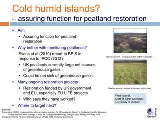
- 1. Cold humid islands? – assuring function for peatland restoration Aim Assuring function for peatland restoration Why bother with monitoring peatlands? Evans et al (2019) report to BEIS in response to IPCC (2013) UK peatlands currently large net sources of greenhouse gases Could be net sink of greenhouse gases Many ongoing restoration projects Restoration funded by UK government and EU, especially EU LIFE projects Who says they have worked? Where to target next? Sources: Evans et al. (2017). Implementation of an emission inventory for UK peatlands. Report to the Department for Business, Energy and Industrial Strategy, Centre for Ecology and Hydrology, Bangor.88pp. Made public May 2019. Intergovernmental Panel on Climate Change (IPCC) 2013 Wetlands Supplement Bleaklow summit – eroding peat after wildfire in April 2003 Bleaklow summit – restored and growing cotton grass Fred Worrall, Dept of Earth Sciences, University of Durham
- 2. Cold humid islands? - Hypothesis Damaged peatland Functioning peatland Dark surfaces Dry surfaces Warm surfaces Wet surfaces Green surfaces Cool surfaces Restoration Surface recession Aggradation GHG sources GHG sinks BareburntpeatafterSaddleworthMoorfire Sphagnummossisthemainpeatformingplant
- 3. Cold humid islands? - EO techniques Damaged peatland DataAnalytic Engine Dark surfaces Dry surfaces Warm surfaces Surface recession GHG sources Soil moisture Albedo & land cover LS temperature Sentinel 1 Greenhouse gases ESA EO data products Targeting Assurance Published Output to users
- 4. Cold humid islands? - Any evidence? Thorne Moors UK’s largest lowland bog Dugover for horticultural peat In Natural England management since 2004 EO study LST and albedo tracked since 2000 Surrounding arable land used as a control Peatland now up to 2oC cooler than Thorne Moors now fully vegetated LST data across Thorne Moors Worrall et al. (2019) JGR-Biogeosciences, 124, 6, 1696-1713.
- 5. Cold humid islands – what do we need to do? Wrangle Provide the right data, right timescales in the right units and spatial scale Analyse Provide the added benefit of combining datasets and the analytics Calibrate Calibrate against existing monitoring sites 9 Eddy flux towers across UK peatlands give energy and CO2 balance Automate Code the system so that above is automatic
- 6. Cold humid islands – delivering climate policy The IPCC (2013) means we need to include emissions from our peatlands Evans et al. (2019) UK peatlands currently a net source of GHG of – 23 Mtonnes CO2eq/yr UK peatlands could be a net sink GHG of +0.25 Mtonnes Therefore large capacity for emissions reduction (avoided loss) Large scope for action 12% of UK is peatland Only 22% of our peatlands are in natural or near-natural condition Peatlands provide lots of other ecosystem services, eg. water. Gully erosion on Pennine moorland – just imagine how much peat, and therefore how much carbon is missing F from this scene.
- 7. Cold humid islands – what service will be provided? Presented data Data must be in a format visible and searchable by end user End users include: o Government agencies (eg. Natural England) o Trusts, eg. The National Trust o Land owners o General public What is provided? Is your bog functioning as a bog? o Data can been calibrated o Data is compared to controls Is your bog improving? o Data cube to give time series of bog function Map of UK peat – from IUCN
- 8. Cold humid islands – what is needed? EO practitioners Make sure we are getting access to the best data AI specialists We are experts in the analysis of designed experiments We are experts in Bayesian modelling We don’t have experience of machine learning Platform development The data must be visible and searchable by end users Revegetated lowland raised bog – cotton grass is a peat forming species. Near natural blanket bog in the North Pennines.