PFBE Projects: Sherford: Part 7/16 Sustainability and Tradition
•
0 likes•242 views


Recommended
More Related Content
What's hot
What's hot (14)
Similar to PFBE Projects: Sherford: Part 7/16 Sustainability and Tradition
Similar to PFBE Projects: Sherford: Part 7/16 Sustainability and Tradition (20)
More from The Prince's Foundation for the Built Environment
More from The Prince's Foundation for the Built Environment (12)
Recently uploaded
Recently uploaded (20)
PFBE Projects: Sherford: Part 7/16 Sustainability and Tradition
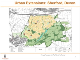
- 1. Urban Extensions: Sherford, Devon 45 59 68 21 31 N 9 13 12 12 12 9 9 3 14 9 2 6 2 14 9 8 9 12 9 12 8 9 11 1 7 16 10 5 9 4 16 15 9 8 2 12 STANDARHAY CLOSE HAZEL DRIVE LB HARTW ELL AVENUE Reproduced from the Ordinance Survey map with the permission of the Controller of Her Magestys' Stationery Office. Licence Number 0100031673 Crown Copyright Reserved Key 1 - Secondary School 9 - Wildlife and Green corridors Project Drawing title Scale size 0 25 50 100 m The Prince's Foundation 2 - Primary School 10 - Sherford quarry (disused) 1:5000 @ A1 Drawn Checked 19-22 Charlotte Road 3 - Health Centre & Children's Centre 11 - Existing woodlands ILLUSTRATIVE DP/IM/TY SG London, EC2A 3SG SHERFORD Tel: 0207 613 8500 4 - Sports Centre 12 - Existing farm houses and buildings Fax: 0207 613 8599 5 - Youth Centre 13 - Park and Ride interchange Client Date 6 - High Street 14 - Key Feature Building TOWN PLAN REDTREE 09.11.2006 enquiry@princes-foundation.org www.princes-foundation.org 7 - Community Park 15 - King George V playing fields THIS DRAWING MAY BE USED ONLY FOR Drawing number Rev THE PURPOSE INTENDED AND ONLY 8 - Outdoor Sports Facilities 16 - Community Wind Turbines WRITTEN DIMENSIONS SHALL BE USED 038-III/11.1001 OPA Prince’s Foundation with Paul Murrain for Redtree 14
- 2. Urban Extensions: Sherford, Devon Prince’s Foundation with Paul Murrain for Redtree 14