Caribbean islands map showing locations and distances
•
1 like•2,013 views

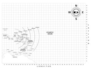
This document is a map showing the Caribbean islands. It displays the names and locations of islands such as the Turks and Caicos Islands, the British Virgin Islands, Puerto Rico, the Dominican Republic, Cuba, Jamaica, and other Caribbean nations. Distances in miles from locations like Santo Domingo, San Juan, and Caracas are included. Landmasses and bodies of water in the region are prominently featured on the map.
Recommended

Recommended
More Related Content
What's hot
What's hot (12)
Similar to Caribbean islands map showing locations and distances
Similar to Caribbean islands map showing locations and distances (16)
More from Lizbeth
More from Lizbeth (20)
Recently uploaded
Recently uploaded (20)
Caribbean islands map showing locations and distances
- 1. N 32 31 30 W E 29 28 27 S 26 25 24 L 23 600 millas 500 millas 22 A Caicos Islands Turks Is. 400 millas 200 millas 300 millas 21 T 100 millas ATLANTIC 20 British VIRGIN ISLANDS OCEAN I Dominican Puerto Republic Rico Culebra 19 Santo San Juan St. Thomas Domingo Vieques St. Marteen Anguila St. Barthelemy 18 T Barahona Saona Mona St. Eustatius Island St. Croix Nevis Barbuda Island Monserrat Antigua U.S. LEEWARD 17 U VIRGINS ISLANDS Guadeloupe SOTAVENTO Marie Galante 16 Dominica D 15 Martinique St. Lucia 14 St. Vincent Barbados Aruba WINWARD 13 Bonaire BARLOVENTO The Grenadines Grenadas Curacao 12 Los Roques Is. Margarita Is. Port of Spain Tobago Tortuga 11 Trinidad Caracas 10 VENEZUELA 9 8 71 70 69 68 67 66 65 64 63 62 61 60 59 58 57 56 55 54 53 52 51 50 49 48 47 46 45 44 43 42 41 40 39 38 37 L O N G I T U D